Designing IA for AI - Information Architecture Conference 2024
J willis
1. Prediction of Sediment Yield
Plains Grasslands with the
versa1 Soil Loss Equation
S.J. SMITH, J.R. WILLIAMS, R.G. MENZEL, AND G.A. COLEMAN
Abstract
Amounts of sediment perrunoffevent from grasslandwatersheds
ln the Texas Blackland prairie, Southern High Plains, Central
Rolling Red Prairies, and Central Rolling Red Plains land
resource areas of Oklahoma and Texas were predicted using the
modified Universal Soil Loss Equation (MUSLE). Inthis quatlon,
Y q 11.8(Qck,)066KCPSL
whereY =sediment yieldin metrictons, Qq runoff volume in m3,9p
=peak runoff rate in ma/set, K =soil erodibility factor, C =crop
management factor, P q erosion control-practice factor, and SL =
slope length, gradientfactor. Periods of study were3 to 5yearsand
included treatments involving grazing density, fertilization, culti-
vation, and burning. Over the range of watersheds, average mea-
sured sediment yield varied from less than 10 to more than 800
kg/ha/event. In most cases, the predicted values compared favor-
ably to the tleid measured values.
Accurate prediction of sediment yield from watersheds is impor-
tant from land use, management, and environmental standpoints.
To aid in this prediction Williams (1975) developed the Modified
Universal Soil Loss Equation (MUSLE), by replacing the rainfall
energy factor of the USLE (Wischmeier and Smith 1960) with a
runoff energy factor. The energy factor in MUSLE is a function of
the product of the runoff volume and the peak runoff rate for an
individual storm. As noted by Williams (1981), MUSLE has cer-
tain advantages over USLE, especially in simulating sediment yield
from a watershed. The advantages include (I) application to indi-
vidual storms, (2) elimination of the need for sediment delivery
ratios because the runoff factor reflects energy used in sediment
transport as well as in sediment detachment, and (3) greater accu-
racy because runoff generally accounts for more sediment yield
variation than does rainfall. In fact, the Sedimentation Task
Committee (1970) of the Hydraulics Division, American Society of
Civil Engineers, has stated that runoff is the best single indicator of
sediment yield. To date, initial results with MUSLE have been
encouraging (Williams 1981, Cooley and Williams 1983, Smith et
al. 1983) but additional testing is necessary to fully document the
equation’s utility in specific land resource areas and under different
land management conditions. The present study involves applica-
tion of the equation to grassland watersheds in the Texas Black-
land Prairie (BP), Southern High Plains (HP), Central Rolling
Red Prairies (RP), and Central Rolling Red Plains (RRP) major
land resource areas of Oklahoma and Texas (Soil Conservation
Service 1981).
Procedures and Watersheds
Equation Development
In the original development of MUSLE (Williams 1975), mea-
Authors are soil scientist, hydraulic engineer, soil scientist, and hydraulic engineer,
respectively. Address of Smith, Menzcl, and Coleman is Water Quality and
Watershed Research Laboratory, P.O. Box 1430, Durant, Okla. 74702. Address of
F;;;,rns is Grassland, Soil, and Water Research Lab., P.O. Box 748, Temple, Tex.
Technical assistance by ARS personnel at El Reno and Woodward, Okla., and
Bushland and Temple, Tex., is gratefully acknowledged.
Manuscript accepted October 20, 1983.
from Southern
Modified Uni-
sured data provided runoff rates and volumes to form the runoff
energy factor. This factor was then substituted for the rainfall
energy factor in the USLE and an optimization technique (DeCour-
sey and Synder 1969) was employed to determine the prediction
equation. This equation, MUSLE, may be stated as:
Where Y q sediment yield in metric tons,
Q= runoff volume in m3,
% = peak runoff rate in rn3/set,
K= soil erodibility factor,
c= crop management factor,
P= erosion control-practice factor, and
SL = slope length, gradient factor.
Y q Il.8 (Qq,,)OmKCPSL
Except for substituting the runoff energy factor, 11.8 (Qqp)o.ssfor
the rainfall energy factor in USLE, the remainder of the equation is
identical to USLE.
Watersheds
General details about the watersheds are included in the left part
of Table 1. More specific information has been provided in earlier
publications (Sharpley et al. 1982, Smith et al. 1983). Suffice it to
note here that the watersheds provided good representation of the
land resource areas, encompassing a range of soils, slopes, and
grasses. Size varied from 0.04 to 122 ha and periods of study were 3
to 5 years. Watershed slopes ranged from 1 to almost 9%. During
the period of study annual rainfall ranged from 43 to 95 cm, and
mean annual runoff ranged from 1.2 to 24cm. Treatments included
annual grazing, deferred grazing, fertilization, spring burning, and
cultivation. Grazing intensities varied from none (HP) to double
stocking (RP, FR I). Prior to the study, the BP and HP watersheds
were in tame/ virgin grassland or cropland, and all others were in
good condition, virgin grassland. After 2 years half of the RP and
RRP watersheds were placed in continuous wheat. The BP and HP
continuous cropland watersheds, which were in sorghum-cotton-
oats and wheat-sorghum-fallow rotations, respectively, have been
included mainly for comparative purposes.
Field Measurement and Sampling
Except for the small O&t-ha HP grassland watersheds, runoff
was measured using precalibrated flumes or weirs equipped with
FW-1 stage recorders. Sediment discharge was collected from
suspended sediment concentrations taken automatically for the
duration of each hydrograph. After comparison with the runoff
hydrograph, samples for a specific watershed were cornposited in
proportion to total flow to provide a single representative sample
of liquid and sediment. In the case of the HP grassland watersheds,
a “splitting device” was employed that collected about I/ 10 of the
respective runoff. Sediment concentration was determined gravi-
metrically after removal of liquid.
Testing Procedure
For each watershed, the MUSLE predictions were determined
using runoff energy factors which involved measured runoff
volumes and peak flow rates from individual events. The other
JOURNAL OF RANGE MANAGEMENT 37(4), July 1984 295
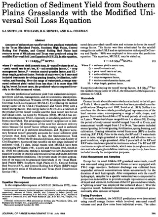
2. Table 1. Sediment yield characteristics of Southern Plains watersheds.
Major land
Res. area’ Watershed
Size
ha
Average
Period of Number of Mean yield/event Std. Dev. Regression
“‘&l-Je
record events Meas. Pred. Meas. Pred. R* slope
BP
HP
RP
RRP
SWll 1.08 0.98 77-80 20
WI0 7.97 2.10 76-80 18
Y14 2.27 1.38 77-80 28
NG 0.04 1.00 78-80 4
SG 0.04 1.00 78-80 4
FRI 1.62 2.58 77-80 20
FR2 1.62 2.88 77-80 17
FR3 1.62 3.18 77-80 19
FR4 1.62 3.64 77-80 21
WWl 4.80 7.00 77-80 34
ww2 5.56 8.20 77-80 54
RP
RRP
FRS 1.62 3.48 77-80
FR6 1.62 2.88 77-80
FR7 1.62 2.88 77-80
FR8 1.62 2.73 77-80
ww3 2.71 8.60 77-80
ww4 2.91 7.40 77-80
;:
28
29
29
40
BP Y 122 2.57 7680 SO
Y2 53 2.86 76-80 34
BP Y6 6.6 3.21 76-80 24
Y8 8.4 2.24 76-80 18
YIO 7.5 1.88 76-80 23
HP GIO 3.3 1.80 78-80 16
Gil 2.6 2.00 78-80 19
Gl2 2.1 2.20 78-80 IS
b/h-
Grasslands
278 287 349 376
23 23 21 23
124 128 280 264
8 9 10 I1
14 I3 22 16
; 87 13IS 1516
8 9 20 19
IS IS 59 56
10 I1 2s 23
111 111 299 255
Grasslands to Wheat Lands
SO 63 157 198
46 47 133 148
25 37 64 9s
26 18 71 36
51 51 168 164
38 37 99 85
Mixed Lands (Grasslands and Croplands)
74 58* 118
148 174 191 2::
Croplands
542 534 481 364
343 343 550 487
812 632 1125 783
396 386 859 782
364 286 798 640
428 531 827 1060
0.91 0.89
0.88 0.84
0.77 0.93
0.97 0.84
0.92 1.30
0.89 0.84
0.96 0.95
0.96 1.08
0.99 1.05
0.94 1.06
0.88 1.10
1.00
0.94
0.99
0.69
1.00
0.88
0.80
0.87
0.67
1.66
1.02
1.09
0.90 1.36
0.83 0.75
0.60 1.02
0.98 1.12
0.84 1.32
0.99 1.09
0.98 1.23
0.94 0.76
*Statistically different at S% level from measured value using the t-test, paired data.
‘BP, Texas Blackland Prairie; HP, Southern High Plains; RP, Central Rolling Red Prairie; RRP, Central Rolling Red Plains.
factors, K,C,P, and SL. in Eq. [I], were obtained from Agricultural
Handbook 537 (Wischmeier and Smith 1978). In the case of the
grasslands, P was unity and K, C, and SL ranged from0.28 to 0.37,
0.002 to 0.400, and 0.14 to 1.05, respectively. Statistical methods
were conducted using standard procedures as outlined in Snedecor
(1956). In the case of the linear regression analysis, a slope greater
than unity indicates sediment yield is overpredicted, whereas a
slope less than unity indicates sediment yield is underpredicted.
Results and Discussion
A comparison of the MUSLE predicted and the actual measured
amounts of sediment yield on an event basis for the individual
watersheds is detailed in the right part of Table 1. Obviously, a
wide range of results within and among watersheds was obtained,
with mean sediment yields per event ranging from essentially none
to as much as 812 kg/ ha on the Y 10 cropland watershed. Predic-
tion of mean sediment yields and respective standard deviations
was quite satisfactory, particularly in the case of the continuous
grassland watersheds. In general, R2values for both grasslands and
croplands were 0.8 or higher and the regression slopes were close to
unity. Moreover, using the paired t-test as a basis for difference,
only the Y mixed land-use watershed (containing both grassland
and cropland subwatersheds) exhibited a statistical difference @ =
0.05) between the predicted and measured sediment yields. Even
here, the predicted and measured means, 58 and 74 kg/ha/event,
respectively, were fairly close. Therefore, when viewed in light of
the wide range of land uses and conditions involved, the general
utility of MUSLE is considered good.
While knowledge of sediment yield on an event basis is necessary
from a water quality/ environmental modeling standpoint, annual
Table 2. Measured and predicted runoff and sediment yields for Texas Blackland Prxirie grasslandsl.
Annual runoff Annual sediment yield
Period of Mean Std. Dev. Mean Std. Dev.
Watershed record Meas. Pred Meas. Pred. Meas. Pred. Meas. Pred.
SW-I I
kg/ ha
77-80 IS l? 14 12 1330 1110 930 820
WI0 76-80 25 26 13 13 82 82 98 44
Y14 77-80 20 24 14 16 820 1040 Ill0 1810
‘Predictions from EPIC Model (Williams, et al., 1982).
296 JOURNAL OF RANGE MANAGEMENT 37(4), July 1994
3. t
o Grassland /’
X Grassland to Wheatland
/
./ I
0 Mixed land
(Grossland and Cropland)
z
I0 Cropland
= -
a25
1000
?
MEASURED MEAN ANNUAL
SEDIMENT YIELD (kg/ha)
Fig. 1. A comparison of the MUSLEpredictedandactual measuredmean
annrurlsediment yields for the warersheds.
sediment yields are often desired from a land management/ conser-
vation planning standpoint. Figure. 1 is a plot of the mean annual
MUSLE predicted and the actual measured sediment yields for the
various watersheds. Mean annual measured sediment yields ranged
from 10 kg/ ha for the NG, HP grassland watershed to 3,700 kg/ ha
for the YIO, BP cropland watershed. In general, MUSLE per-
formed satisfactorily for all the watershed types, with the good fit
between mean annual predicted and measured sediment yields for
the grasslands particularly evident. In view of the fact that the Soil
Conservation Service tolerable annual soil loss limits for the RRP
grasslands and other watersheds are 5,550 and 11,100 kg/ ha,
respectively’, none of the watersheds posed serious erosion prob-
lems during the study periods (3 to 5 years). This encouraging piece
of information should be tempered, however, by the statement that
the grassland watersheds were all in good condition prior to initia-
tion of the study, and the cropland watersheds were farmed accord-
ing to recommended practice.
The test results in the present study were made using measured
runoff volumes and peak runoff rates. In general practice, how-
ever, such information is not available. In these cases MUSLE may
be linked with hydrologic simulation models (Williams and Berndt
1977) to provide estimates of (Qqp) in Eq. (I). As
Tolerable annual soil losses. File copy received1981,SCS, Stillwater,Okla.
an example, MUSLE was combined with several other hydrologic
components to form the EPIC (Erosion-Productivity Impact Cal-
culator) model (Williams et al. 1982). Preliminary results (Table 2)
using an estimated (Qqp) term from the EPIC model are encourag-
ing.
Overall, the results of this study leave little doubt that MUSLE
can be a useful tool for predicting sediment yields from grassland
watersheds in major land resource areas of the Southern Plains.
Moreover, results with the mixed land-use watersheds (containing
both grassland and cropland subwatersheds) support the view
(Williams 1981) that MUSLE has utility on a multiple as well as
individual watershed basis. Consequently, MUSLE may have
application to larger, basin-scale, land areas.
Literature Cited
Cooley, K.R., and J.R. Williams. 1983. Applicability of the USLE and
MUSLE to Hawaiian Agricultural Lands. In: Proc. Internat. Conf. on
Soil Erosion and Conservation, Honolulu, Hawaii.
DeCoursey, D.&and W.M. Snyder. 1969. Computer-oriented method of
optimizing hydrologic model parameters. J. Hydrology 9:34-56.
Sedimentation Task Committee. 1970. Sedimentation engineering, Chap.
IV. Sediment sourcesand sediment yields. Proc. Amer. Sot. Civil Engr.
96 (HY6):1283-1329.
Sherpley, A.N., SJ. Smith, and R.G. Menzel. 1982. Prediction of phos-
phorus losses in runoff from Southern Plains watersheds. J. Environ.
Qual. 11:247-251.
Smith, SJ., R.G. Menzel, E.D. Rhoades, J.R. Williams, and H.V. Eck.
1983. Nutrient and sediment discharge from Southern Plains grasslands.
J. Range Manage. (Accepted for publication).
Snedecor, G.W. 1956. Statistical Methods, 5th Ed. Iowa State Univ. Press,
Ames.
Soil Conservation Service. 1981. Land resource regions and major land
resource areas of the United States. USDA , Agr. Handbook 296,
Washington, D.C.
Williams, J.R. 1975. Sediment-yield prediction with Universal Equation
using runoff energy factor. p. 244-252. In: Present and Prospective
Technology for Predicting Sediment Yield and Sources. U.S. Dep. Agr.
ARS-S40.
Williams, J.R. 1981.Testing the modified Universal Soil Loss Equation. p.
157-164. In: Estimating Erosion and Sediment Yield on Rangelands.
USDA. ARM-W-26.
Williams, J.R., and H.D. Berndt. 1977. Sediment yield prediction based on
watershed hydrology. Trans. Amer. Sot. Agr. Eng. 20:1100-l 104.
Willlams, J.R., P.T. Dyke, and CA. Jones. 1982. EPIC-A model for
assessing the effects of erosion on soil productivity. In: Proc. Third Int.
Conf. on State-of-the-Art in Ecological Modeling, Fort Collins, CO.
Wischmeier, W.H. and D.D. Smith. 1960. A universal soil-loss equation to
guide conservation farm planning. 7th Int. Cong. Soil Sci. Trans.
1:418-425.
Wischmeier, W.H. and D.D. Smith. 1978. Predicting rainfall erosion
losses. U.S. Dep. Agr., Sci. Ed. Admin., Agr. Handbook 537. Washing-
ton, D.C.
JOURNAL OF RANGE MANAGEMENT 37(4). July 1984 297
![Table 1. Sediment yield characteristics of Southern Plains watersheds.
Major land
Res. area’ Watershed
Size
ha
Average
Period of Number of Mean yield/event Std. Dev. Regression
“‘&l-Je
record events Meas. Pred. Meas. Pred. R* slope
BP
HP
RP
RRP
SWll 1.08 0.98 77-80 20
WI0 7.97 2.10 76-80 18
Y14 2.27 1.38 77-80 28
NG 0.04 1.00 78-80 4
SG 0.04 1.00 78-80 4
FRI 1.62 2.58 77-80 20
FR2 1.62 2.88 77-80 17
FR3 1.62 3.18 77-80 19
FR4 1.62 3.64 77-80 21
WWl 4.80 7.00 77-80 34
ww2 5.56 8.20 77-80 54
RP
RRP
FRS 1.62 3.48 77-80
FR6 1.62 2.88 77-80
FR7 1.62 2.88 77-80
FR8 1.62 2.73 77-80
ww3 2.71 8.60 77-80
ww4 2.91 7.40 77-80
;:
28
29
29
40
BP Y 122 2.57 7680 SO
Y2 53 2.86 76-80 34
BP Y6 6.6 3.21 76-80 24
Y8 8.4 2.24 76-80 18
YIO 7.5 1.88 76-80 23
HP GIO 3.3 1.80 78-80 16
Gil 2.6 2.00 78-80 19
Gl2 2.1 2.20 78-80 IS
b/h-
Grasslands
278 287 349 376
23 23 21 23
124 128 280 264
8 9 10 I1
14 I3 22 16
; 87 13IS 1516
8 9 20 19
IS IS 59 56
10 I1 2s 23
111 111 299 255
Grasslands to Wheat Lands
SO 63 157 198
46 47 133 148
25 37 64 9s
26 18 71 36
51 51 168 164
38 37 99 85
Mixed Lands (Grasslands and Croplands)
74 58* 118
148 174 191 2::
Croplands
542 534 481 364
343 343 550 487
812 632 1125 783
396 386 859 782
364 286 798 640
428 531 827 1060
0.91 0.89
0.88 0.84
0.77 0.93
0.97 0.84
0.92 1.30
0.89 0.84
0.96 0.95
0.96 1.08
0.99 1.05
0.94 1.06
0.88 1.10
1.00
0.94
0.99
0.69
1.00
0.88
0.80
0.87
0.67
1.66
1.02
1.09
0.90 1.36
0.83 0.75
0.60 1.02
0.98 1.12
0.84 1.32
0.99 1.09
0.98 1.23
0.94 0.76
*Statistically different at S% level from measured value using the t-test, paired data.
‘BP, Texas Blackland Prairie; HP, Southern High Plains; RP, Central Rolling Red Prairie; RRP, Central Rolling Red Plains.
factors, K,C,P, and SL. in Eq. [I], were obtained from Agricultural
Handbook 537 (Wischmeier and Smith 1978). In the case of the
grasslands, P was unity and K, C, and SL ranged from0.28 to 0.37,
0.002 to 0.400, and 0.14 to 1.05, respectively. Statistical methods
were conducted using standard procedures as outlined in Snedecor
(1956). In the case of the linear regression analysis, a slope greater
than unity indicates sediment yield is overpredicted, whereas a
slope less than unity indicates sediment yield is underpredicted.
Results and Discussion
A comparison of the MUSLE predicted and the actual measured
amounts of sediment yield on an event basis for the individual
watersheds is detailed in the right part of Table 1. Obviously, a
wide range of results within and among watersheds was obtained,
with mean sediment yields per event ranging from essentially none
to as much as 812 kg/ ha on the Y 10 cropland watershed. Predic-
tion of mean sediment yields and respective standard deviations
was quite satisfactory, particularly in the case of the continuous
grassland watersheds. In general, R2values for both grasslands and
croplands were 0.8 or higher and the regression slopes were close to
unity. Moreover, using the paired t-test as a basis for difference,
only the Y mixed land-use watershed (containing both grassland
and cropland subwatersheds) exhibited a statistical difference @ =
0.05) between the predicted and measured sediment yields. Even
here, the predicted and measured means, 58 and 74 kg/ha/event,
respectively, were fairly close. Therefore, when viewed in light of
the wide range of land uses and conditions involved, the general
utility of MUSLE is considered good.
While knowledge of sediment yield on an event basis is necessary
from a water quality/ environmental modeling standpoint, annual
Table 2. Measured and predicted runoff and sediment yields for Texas Blackland Prxirie grasslandsl.
Annual runoff Annual sediment yield
Period of Mean Std. Dev. Mean Std. Dev.
Watershed record Meas. Pred Meas. Pred. Meas. Pred. Meas. Pred.
SW-I I
kg/ ha
77-80 IS l? 14 12 1330 1110 930 820
WI0 76-80 25 26 13 13 82 82 98 44
Y14 77-80 20 24 14 16 820 1040 Ill0 1810
‘Predictions from EPIC Model (Williams, et al., 1982).
296 JOURNAL OF RANGE MANAGEMENT 37(4), July 1994](data:image/gif;base64,R0lGODlhAQABAIAAAAAAAP///yH5BAEAAAAALAAAAAABAAEAAAIBRAA7)