Recommended

Recommended
More Related Content
What's hot
What's hot (20)
Similar to Measuring SC Forest Water Budget
Similar to Measuring SC Forest Water Budget (20)
Recently uploaded
Recently uploaded (20)
Measuring SC Forest Water Budget
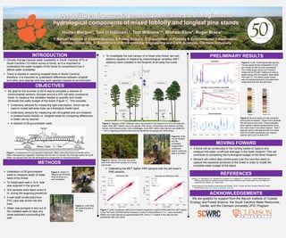
- 1. To investigate the sub canopy of a mixed pine forest, two sub stations capable of measuring meteorological variables (MET stations) were installed in the footprint of an eddy flux tower. Jenkins, J.P., Richardson, A.D., Braswell, B.H.,Ollinger, S. V., Hollinger D. Y., Smith, M.-L. (2006). Refining light-use efficiency calculations for deciduous forest canopy using simultaneous tower-based carbon flux and radiometric measurements. Elsevier. pp. Pages 66-65. South Carolina’s Forest Resource Assessment and Strategy (2010). Conserving South Carolina’s Working Forests. Retrieved from https://www.state.sc.us/forest/fra-cons.htm Climate change impacts water availability in South Carolina. 67% of South Carolina (13 million acres) is forest, so it is important to understand the water budgets of the forest to comprehend how it affects water availability There is interest in restoring longleaf pines in South Carolina; therefore, it is important to understand differences between longleaf and other pine species and how each species impacts its environment. INTRODUCTION PRELIMINARY RESULTS A flume will be constructed in the coming weeks to capture and measure the water runoff and drainage in the tower footprint. This will contribute to completing the hydrological budget of the tower footprint. Sensors will collect data continuously over the next few years to capture the seasonal dynamics of the forest in order to model the complete water budget of the stand. MOVING FOWARD We are grateful for support from the Baruch Institute of Coastal Ecology and Forest Science, the South Carolina Water Resources Center, and the Clemson University UPIC Program. ACKNOWLEDGEMENTS Figure 1. Components of a low-gradient watershed. Water enters the forest as rainfall and is either intercepted by vegetation, absorbed into the soil, or directed into drainage basins as runoff. Water can escape back into the atmosphere by evaporation or evapotranspiration. Installation of 28 groundwater wells to measure depth of water table of the forest To install each well a 10 ft. hole was augured in the ground. Soil samples were taken every 6 in. during the auguring procedure. A well shaft constructed from PVC pipe was driven into the hole. Water was pumped in and out of the installed wells to clear any loose sediment surrounding the well. Calibrating the MET station PAR sensors with the tall tower’s PAR sensors Figure 7. Initial comparison (left) and corrected comparison (right) of PAR data from MET station vs the Tall Tower (all PAR sensor measure in units of umol photons m-2 s-1). Upon correction, RMSE error was reduced by approximately 50%, and a 1:1 relation in the data set was established with zero offset. Figure 3. (Left) Well #4 collecting date in the field. Figure 4. Diagram of MET Stations, which are located in the footprint of a 37m tall eddy flux tower. Each MET Station has a rain gauge, PAR sensor, temperature and relative humidity sensor, soil moisture probe, and a datalogger. Each MET station also has two sub platforms ~10m in opposing directions that have an additional rain gauge and PAR sensor. Figure 8. (Left) Hydrological data figures. The top graph shows precipitation in mm per minute as well as total precipitation. The middle graph shows soil moisture measured by the MET stations at various depths along with the weather table depth from well 15. The bottom graph shows rate of evapotranspiration calculated from measurements from the tall tower. Figure 9. (Above) Scans of soils extracted during well excavation. These scans illustrate the soil texture and color. These examples show aquifer material representative of the two major soils in the tower footprint. Well 7 features sandy soils stained with iron oxide. Well 20 contains spodosols over organic- stained sand down to about 8 ft. Figure 2. (Right) Dr. Williams and Michael Kline working on a well installation. Figure 5. (Above) The eddy flux tower seen from above the canopy of a mixed pine forest. PRELIMINARY RESULTS ACKNOWLEDGEMENTS INTRODUCTION METHODS Figure 6. (Left) Hunter Morgan and the completed longleaf MET understory station collecting data in the field. 36.5 m 18 m 21 m batteries log 2 m 12 m 24 m 30 m 33 m SPN1 PRI PAR NET RAD Cell GPS CO2, H2O and heat fluxes Tair, RH Tair, RH Tair, RH Longleaf Pine Loblolly Pine Tair, RH MET STATION MET STATION Tair, RH Tair, RH PAR PAR Rain gauge Rain gauge Soil moisture Soil moisture log log REFERENCES My goal for the summer of 2019 was to complete a network of environmental sensors, focused around a 37m tall eddy covariance tower, to measure the variables needed to quantify and model (forecast) the water budget of the forest (Figure 1). This includes: Understory sensors for measuring light interception, which can be used to model leaf area index as a biological model input Understory sensors for measuring rain throughfall and soil moisture in predominantly loblolly vs. longleaf areas for comparing differences in water use by species A network of 28 groundwater wells OBJECTIVES