Region II: Cagayan Valley
•Download as PPTX, PDF•
33 likes•57,067 views

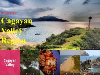
Tourist attractions of the Cagayan Valley Region

Recommended
More Related Content
What's hot
What's hot (20)
Viewers also liked
Viewers also liked (20)
Similar to Region II: Cagayan Valley
Similar to Region II: Cagayan Valley (20)
More from Kate Sevilla
More from Kate Sevilla (20)
Recently uploaded
Recently uploaded (20)
Region II: Cagayan Valley
- 2. Area and Location Located at the Northern part of mainland Luzon, covering an area of about 26, 858.79 sq.km.. Bounded on the east by the Sierra Mountain Range, on the west by the Caraballo and Cordillera Ranges, and on the north by South China Sea.
- 3. Geographic Profile •December-May : Dry season •June-November: Wet season •March-May: Hot months/summer (sometimes extending up to August People Population (2007)- 3,056,487 (2010)- 3,229,163 Dialect: Ilocano, Ibanag, Itawes and Tagalog. In Batanes, people speak Ivatan. English is generally understood and spoken regionwide.
- 4. Political Profile •Composed of five provinces.
- 6. How to get there?
- 7. Cagayan Capital: Tuguegarao City Name and Location Description Aggao Nak Cagayan Province-wide This is also known as Cagayan Day, celebrated every June 29. Aparri Delta Aparri Is an impressive expanse of water that is located where the Cagayan River meets the South China Sea. From the jetty, one can see the awesome mouth of the Cagayan River. Buntun Bridge Buntun, Tuguegarao At 1.224 km, this bridge is the second longest in the country and offers an obstructed view of the Cagayan River. It is located at the town proper of Tuguegarao. Cagayan River or Rio Grande de Cagayan Large parts of the province Is the Philippines’ mightiest watercourse- the longest and widest river in the country. It originates form small steams coming from Balete pass, Cordillera, Caraballo, and the Sierra Madres that meet other streams and river in the area. Callao Caves Aggugagdan, Penablanca These caves boast massive limestone and other rock formations, skylights and a chapel. The circadian flight og thousands of bats from their cave at dusk is also a major attraction.
- 8. Cagayan Capital: Tuguegarao City Name and Location Description Iguig Calvary Hills Iguig A duplicate of the 14 stations of the Cross is situated a top an 11-hectare rolling terrain overlooking the Cagayan River. Oldest Bell in Southest Asia Calmaniugan The bell is in Calmanuigan’s Jacinto de Polonia Parish. Forged in 1595, it was brought to Manila in February 1937 as part of the attractions during the 33rd International Eucharistic Congress. St. Peter’s Cathedral Poblacion, Tuguegarao This is the seat of the archdiocese of Tuguegarao. A picture of it hangs in the Basilica in Rome. It is considered one of the most beautiful work of art in the world. The Miraculous Lady of Piat Piat Considered the Antipolo of Northern Luzon, the Mecca of the devoted, and the pilgrimage center of Cagayn Valley. Camiguin Norte Babuyan Islands It has a high quality natural attractions which include the humpback whales, dolphins and impressive islands.
- 9. Isabela Capital: Ilagan Name and Location Description Aguinaldo Shrine Palanan This was where Gen. Emilio Aguinaldo was captured by American forces, ending the Philippine Revolution in 1901. Church of Alicia Alicia The church is famous for its antique Spanish architecture. Church of Echague Echague This particular church has a unique architecture that is hardly found anywhere in Philippines. Dibulo Waterfalls Dinapigue The waterfall has an estimated length of 100 meters. It is being studied as a possible power and energy sources. Magat Dam Tourism Resort complex Brgy. Aguinaldo, Ramon Asia’s biggest dam project; the reservoir area is suitable for fishing, swimming, boating, sight-seeing and picknicking. Our Lady of Visitation Church Guibang Houses the miraculous Lady of the Visitation which is visited its many devotees, especially every July 2, which is her feast day.
- 10. Isabela Capital: Ilagan Name and Location Description Palanan Rainforest Palanan The Philippines’ largest existing rainforest, situated at 800 feet above sea level. It is home to numerous unknown endemic species of flora and fauna and has exceptional biodiversity. St. Mathias Church Tumauini An 18th century ultra-baroque church unique for its extensive use of baked clay both for wall finishing and for ornamentation; it also has a unique cylindrical bell tower. San Pablo Church San Pablo Built in 1625 under supervision of Spanish missionary Padre de Santo Tomas, it is the oldest church in the province. Nuestra Senora de Atocha Alicia One of the oldest churches in the province, was built during the Spanish period. St. Rose de Lima Church Gamu One of the oldest Spanish churches in the province. Sta. Victoria Caves Fuyo Nat’l Park, Ilagan Famous for its stalactitie and stalagmites, the site is ideal for spelunking.
- 11. Batanes Capital: Basco Name and Location Description Batanes day Basco Is held to commemorate the founding of the islands as a province. It is held every June 26 and features street parades and local contests. Itbayat Island Itbayat Located north of Batan, Itbayat is shaped like giant bowl. The island is surrounded by massive boulders and cliff rising from 20-70 feet above sea level with no shorelines. Marlboro Country Batan Island Is mostly wide open spaces with almost no inhabitants are cows that are let loose to graze. All around is nothing but the panoramic landscape and seascape. Mt. Iraya Basco Is a dormant volcano raising 1,517 ,meters above sea level. Its last eruption was in 505 AD. It is good source of fertile soil. Naidi Hills Basco Offers a panoramic view of the Basco town proper, Mt. Iraya., and the rugged seascapes that Batanes is famous for.
- 12. Batanes Capital: Basco Name and Location Description Sabtang Island Sabtang An undisturbed and unspoiled island that has intermittent white sand beaches, steep mountains, deep canyons, and small level area along the coastline. San Carlos Borromeo Church Mahatao This church was completed in 1789 and stilll retains its centuries-old features. San Jose Church Ivana This church was built in 1814. it has a crenellated fortress like campanile. Y’ami Northernmost island of the province This northernmost island of Batanes is also called Orchid island. One can see Taiwan from here on a clear day. Tztus or coconut crabs abound in the island, as well as many other marine life.
- 13. Nueva Vizcaya Capital: Bayombong Name and Location Description Dalton Pass Nueva Vizcaya Aside from being the gateway to the Cagayan Valley region, Dalton Pass also offers the only direct route between Pampanga and Cagayan Valley. According to history, the pass became the scene of much bloody fighting before the final stages of World War II Dalton Pass Historical Shrine Sta. Fe Standing at about 3,000 feet above sea level, the shrine was built in commemoration of the battle at Balete Pass during World War II. Dupax del Sur Church Dupax Del Sur Covering an area of 7,200 sq.m, it is one of the oldest and biggest churches in the valley. Its architectural design is said to be similar to that of Tuguegarao’s St. Peter’s Cathedral. Kirang Pass Kirang, Aritao A monument in honr of the gallantry of the Filipino soldiers during World war II.
- 14. Nueva Vizcaya Capital: Bayombong Name and Location Description Mt. Pulag Nat’l Park Kayapa A park that serves a gateway to the contry’s second highest peak, that of Mt.Pulag, which rises 9,630 feet above sea level. The park occupies parts of Nueve Vizcaya and Bengeut. Nueva Vizcaya Capitol Bayombong A study of architectural angenuity, the capitol has a park with exotic plant species, concrete benches, sidewalks lighted with giant mercury lamps and a man-made lagoon ideal fro rowing. It also houses all the provincial government offices. Salinas Salt Springs Bayombong A natural wonder consisting of hills made entirely of petrified white salt. St. Dominic Cathedral Nueva Vizcaya This cathedral is a living vintage of the grandeur that was the old town, maintaining its original 18th century Spanish-style facade. It is said to have been first cathedral in the province. Capisaan Caves Capisaan This recently discovered wonder features impressive limestone formation. One can have a great adventure exploring this site.
- 15. Quirino Capital: Cabarroguis Name and Location Description Aglipay Caves Cabarroguis A series of 38 caves, seven of which have already been developed for tourism, offering tourist an interesting contact with nature. Located in an area of undulating hills and rich forest reserve, the caves also feature an underground river. Aglipay Town Aglipay A historic town which got its name from Fr. Gregorio Aglipay, a Filipino priest who rebelled against the Spanish and founded the Philippine Independent Church. Araw ng Quirino Qurino Various tribes participate in this event , which commemorates the birth of the province. Bisangal Waterfalls Madella These falls are situated in a virgin forestland that is considered a haven for wildlife and endangered species. Cabarroguis Falls Cabarroguis This waterfalls is one of the many natural attractions in the province which has a potential for tourism development.
- 16. Quirino Capital: Cabarroguis Name and Location Description Governor Rapids Maddela The site offers swift, turbulent, crystal-clear waters ideal for water activities such as river rafting. It is also famous for its giant wall of limestone jutting out from one side of the Cagayan River, framing the Sierra Madre Nagbukel Cave Diffun The cave is located inside a dome-shaped mountain frequented by domestic tourist during the Holy Week. It is an ideal site for hiking and picnicking. Nagtipunan Town Nagtipunan The town is surrounded by virgin forests and is currently being developed as a gateway to Quezon province. Pongo River Valley Maddela The river valley is a natural area that offers scenic opportunities perhaps some nature activities to the visitors.
- 17. Quirino Capital: Cabarroguis Name and Location Description Upper Cagayan River Basin Nagtipunan The source of the Cagayan River, is presently undergoing development as a camp and picnic grove. Victoria Falls Barrio Sangbay, Nagtipunan Believed to be one of the sources of the Cagayan River that cuts the valley into two and end s at the Aparri Delta.
- 18. Sources: Libosado, Carlos M.: “Domestic Tourism”. Anvil Publishing, Inc. 2010. www.wikipedia.com www.googleimages.com Department of Tourism “It’s more fun in the Philippines”