IJRET-V1I1P3 - Remotely Sensed Images in using Automatic Road Map Compilation
•
1 like•165 views

High Resolution satellite Imagery is an important source for road network extraction for roads database creation, refinement and updating. Various sources of imagery are known for their differences in spectral, spatial, radioactive and temporal characteristics and thus are suitable for different purposes of vegetation mapping. A number of shape descriptors are computed to reduce the misclassification between road and other spectrally similar objects. The detected road segments are further refined using morphological operations to form final road network, which is then evaluated for its completeness, correctness and quality. The proposed methodology has been tested on updating on road extraction from remotely-sensed imagery.

Recommended
Recommended
More Related Content
What's hot
What's hot (20)
Similar to IJRET-V1I1P3 - Remotely Sensed Images in using Automatic Road Map Compilation
Similar to IJRET-V1I1P3 - Remotely Sensed Images in using Automatic Road Map Compilation (20)
More from ISAR Publications
More from ISAR Publications (6)
Recently uploaded
Recently uploaded (20)
IJRET-V1I1P3 - Remotely Sensed Images in using Automatic Road Map Compilation
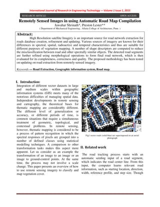
- 1. International Journal of Research in Engineering Technology -– Volume 1 Issue 1, 2015 Remotely Sensed Images in using Automatic Road Map Compilation Jawahar Shrinath*, Preston Lester** ( Department of Mechanical Engineering , Allana College of Architecture, Pune. ) I. Introduction: Integration of different vector datasets in large and medium scales within geographic information systems (GIS) meets many of the notorious difficulties of managing spatial data. Independent developments in remote sensing and cartography, the theoretical bases for thematic mapping are considerably different. The different level of generalization or accuracy, or different periods of time, is common situations that require a simultaneous treatment of geometric, topological, and contextual problems. In remote sensing, however, thematic mapping is considered to be a process of pattern recognition in which the spectral responses of pixels are grouped into a number of defined classes using statistical modelling techniques. A comparison to other transformation tasks makes this aspect more apparent. Let us consider as an example the transformation of an image to an image or an image to ground-control points. At the same time, the process may not involve a scale change. This paper presents an overview of how to use remote sensing imagery to classify and map vegetation cover. Fig1.vector roads (solid blue) are superimposed on an aerial photograph II. Related work The road tracking process starts with an automatic seeding input of a road segment, which indicates the road center line. From this input, the computer learns relevant road information, such as starting location, direction, width, reference profile, and step size. Though Abstract: High Resolution satellite Imagery is an important source for road network extraction for roads database creation, refinement and updating. Various sources of imagery are known for their differences in spectral, spatial, radioactive and temporal characteristics and thus are suitable for different purposes of vegetation mapping. A number of shape descriptors are computed to reduce the misclassification between road and other spectrally similar objects. The detected road segments are further refined using morphological operations to form final road network, which is then evaluated for its completeness, correctness and quality. The proposed methodology has been tested on updating on road extraction from remotely-sensed imagery. Keywords — Road Extraction, Geographic information system, Road map. RESEARCH ARTICLE OPEN ACCESS
- 2. International Journal of Research in Engineering Technology -– Volume 1 Issue 1, 2015 ISSN: 2455-1341 http://www.ijretjournal.org Page 10 roads and soils have same spectral signature, roads have some specific characteristics. Their characteristics can be classified into radiometric, geometric, topological, functional and contextual categories. The geometric characteristics of roads are that they are elongated and have maximum radius of curvature. Their radiometric characteristics intimate that their surface is homogeneous and they have good contrast with the adjacent areas. Their topological characteristics are that they intersect and build a network and they do not stop without a reason. Roads connect cities. It is a functional characteristic of road. Their contextual characteristics suggest that fly-overs and trees cast a shadow on the road surface. All characteristics of road except the functional characteristics are used in our work. The extraction technique can be divided into four parts: Image preprocessing, Spectral signature extraction, Closed contour removal and Morphological operations. Fig2. Road extraction technique The approach is model-based from the outset and is completely different than those appearing in the published literature. It produces two boundaries for each road or four boundaries when a mid-road barrier is present. The map estimation is handled by partitioning an image into windows, realizing the estimation in each window through the use of dynamic programming, and then, starting with the windows containing high confidence estimates, using dynamic programming again to obtain optimal global estimates of the roads present. III.Automatic Road Updating In Vector Road Map: Improving the positional accuracy while keeping the existing attributes creates a better road dataset. Generally, the imagery is more current than the vector data because traditional map compilation and production are time consuming processes. Newly constructed roads are often not shown in vector datasets. The unmatched road intersections from imagery may provide useful clues for automatic extraction of new roads from imagery. These new roads also extracted by using spatial contextual measures. GIS Work: Map conflation is originally an editing operation in GIS to reconcile the position of related features. So the results from map conflation will have a good consistency between the changed and the unchanged road features.GIS can relate unrelated information by using location as the key index variable. Locations or extents in the Earth space–time may be recorded as dates/times of occurrence, andxyz coordinates representing, longitude, latit ude ,and elevation, respectively. All Earth-based spatial–temporal location and extent references should, ideally, be relatable to one another and ultimately to a "real" physical location or extent. This key characteristic of GIS has begun to open new avenues of scientific inquiry. After a Nodes extraction Road extraction Vector road Imagery Road intersection and termination extraction Point pattern matching by relaxation Piecewise local affine transformation Snake correction
- 3. International Journal of Research in Engineering Technology -– Volume 1 Issue 1, 2015 ISSN: 2455-1341 http://www.ijretjournal.org Page 11 successful extraction of road features from the imagery, feature matching is performed to identify the conjugate road nodes and road centrelines from the two versions of the road datasets. A conflation procedure then follows to obtain a new, more accurate road database. Fig.3 Road Extractions Based on GIS Method IV.Results and Discussion: The correctness is defined as the percentage of length of road segments that fall within the buffer over the total length of roads. the proposed method of spatial contextual information extraction. Here road extraction technique is a fully automatic approach.Here the image contains two parts i.e, vegetation and non vegetation areas. Non vegetated areas include roads and buildings. Then binarization method is applied on the extracted image. Binarization technique computes a global threshold automatically that can be used to convert an intensity image to a binary image. Mathematical morphology method is applied on the binary image. Here some unwanted areas are eroded using erosion technique. shows the illustration of automatic road extraction with Clustering. In road extraction technique extraction time is very less. Then road intersections and terminations are obtained from the extracted road. Then these road intersections and terminations are matched with road intersections and terminations of vector road map by using relaxation labeling algorithm. V. Conclusion: This paper covered a wide array of topics in vegetation classification using remote sensing imagery. First, a range of remote sensing sensors and their applications in vegetation mapping were introduced to facilitate the selection of right remote sensing products for specific applications. Second, the techniques of image pre-processing and various classification methods (traditional and improved) were discussed on how to extract vegetation features from remote sensing images. Particularly, the extraction of vegetation cover through the
- 4. International Journal of Research in Engineering Technology -– Volume 1 Issue 1, 2015 ISSN: 2455-1341 http://www.ijretjournal.org Page 12 application of hyper spectral imagery and image fusion was discussed. Third, a section was dedicated to the discussion of result evaluation (accuracy assessment) of image classification. Although the coverage of topics was not inclusive, and not all possible problems were addressed, the basic steps, principles, techniques and methods of mapping vegetation cover from remote sensing imagery were discussed and the supporting references were provided. VI.References [1]M. Barzohar and D. B. Cooper, “Automatic finding of main roads in aerial images by using geometric-stochastic models and estimation,” IEEE Trans. Pattern Anal. Mach. Intell., vol. 18, no. 7, pp. 707–721, Jul. 1996. [2] M. A. Cobb, M. J. Chung, H. Foley, F. E. Petry, and K. B. Shaw, “A rule-based approach for the conflation of attributed vector data,” Geoinformatica,vol. 2, no. 1, pp. 7–35, Mar. 1998. [3] Y. Doytsher, S. Filin, and E. Ezra, “Transformation of datasets in a linear-based map conflation framework,” Surveying Land Inf. Syst., vol. 61, no. 3, pp. 159–169, Sep. 2001. [4] D. Geman and B. Jedynak, “An active testing model for tracking roads in satellite images,” IEEE Trans. Pattern Anal. Mach. Intell., vol. 18, no. 1, pp. 1–14, Jan. 1996. [5] D. M. Mckeown and J. L. Denlinger, “Cooperative methods for road tracking in aerial imagery,” in Proc. Computer Vision and Pattern Recognition, Ann Arbor, MI, 1988, pp. 662– 672. [6] L. H. Quam, “Road tracking and anomaly detection in aerial imagery,” in Proc. Image Understanding Workshop, Pittsburgh, PA, 1978, pp. 51–55. [7] V. Walter and D. Fritsch, “Matching spatial data sets: A statistical approach,” Int. J. Geograph. Inf. Sci., vol. 13, no. 5, pp. 445–473, Jul. 1999. [8] S. Filin and Y. Doytsher. "A Linear Conflation Approach for the Integration Photogram metric Information and GIS Data", International archives of photogrammetry and remote sensing, Volume 33(B3/1): 282-288, 2000. [9] A. Saalfeld, “Conflation: Automated map compilation,” Int. J. Geograph.