The Context and Impacts of the Canterbury Earthquake Sequence of 2010-2011 - Kelvin Berryman
•
1 like•727 views

2013 EERI Annual Meeting Session: 10th Annual SSA/EERI William B. Joyner Memorial Lecture

Recommended
Recommended
More Related Content
Viewers also liked
Viewers also liked (7)
Similar to The Context and Impacts of the Canterbury Earthquake Sequence of 2010-2011 - Kelvin Berryman
Similar to The Context and Impacts of the Canterbury Earthquake Sequence of 2010-2011 - Kelvin Berryman (20)
More from EERI
More from EERI (20)
The Context and Impacts of the Canterbury Earthquake Sequence of 2010-2011 - Kelvin Berryman
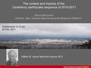
- 1. The context and impacts of the Canterbury earthquake sequence of 2010-2011 Kelvin Berryman Director, New Zealand Natural Hazards Research Platform Christchurch 12.51 pm 22 Feb, 2011 William B. Joyner Memorial Lecture 2013 Natural Hazards Research Science GNS Platform
- 2. In this presentation some discussion of: •regional tectonic setting & earthquake sequence •ground motions & the built environment •social and economic impacts •successes and failures •lessons for Canterbury, NZ and internationally Natural Hazards Research Platform GNS Science
- 3. As well: •the Tuesday workshop (presentations on EERI website), John Hare (performance of built environment), John Hamilton (EM and the Response phase in Christchurch), and David Johnston (societal impacts) •Mary Comerio discussing Christchurch recovery & policy •Art Frankel covering aspects of Christchurch ground motions •Literature already – NZJGG, SRL, Bull NZ Soc EQ Eng •Reports of the Royal Commission of Enquiry (http://canterbury.royalcommission.govt.nz/) •Writing for public consumption, eg. Red Zone Free e-book by Jordan Kelly (http://www.bidstrategist.com/freeresources) •Data from GeoNet and related sites (http://info.geonet.org.nz/display/appdata/Applications+and+Data) •Many conference presentations – AGU, SCEC, SSA •Reports by EERI, TLCEE, GEER, NZ agencies Natural Hazards Research Platform GNS Science
- 4. A few preliminary comments •Impacts and consequences of the Canterbury earthquakes needs to be understood in terms of its rarity. •There were clearly some failures (management of natural hazard risk, inaction on earthquake prone building policy & poor risk communication) but there were also many successes. •Decisions about changed policy and procedures need to keep the rarity of the February 2011 event in mind, otherwise some overly conservative actions may result. •Making a difference - absorbing lessons learned as a memorial to the 185 persons that lost their lives in the February 22nd earthquake – requires ongoing cooperation between engineers, scientists, policy makers, the business community, insurance and politicians. It is at best a work in progress in New Zealand and there is a danger we may slip back into past behaviours and silos. Natural Hazards Research Platform GNS Science
- 5. Natural Hazards Research Platform GNS Science
- 6. New Zealand tectonic and bathymetric Raukumara setting Peninsula CVR/TVZ Oblique subduction of Pacific plate beneath North Island along North Island Hikurangi Trough Dextral Fault Belt ea i at ng u P l ura Oceanic plateau Marlborough k Hi material on Hikurangi strike-slip Plateau Chatham Rise Continental convergence in central South Island Southern Oblique subduction Alps beneath Fiordland Fiordland Image from NIWA National Institute of Water and Atmospheric Research Ltd Natural Hazards Research Platform GNS Science
- 7. Regional Fault Patterns Barnes et al, 2011 Jongens et al, 2012 Natural Hazards Research Platform GNS Science
- 8. An update on the Canterbury earthquake sequence •The regional context •The continuing aftershocks: their frequency and strength •Why was there so much damage to the Canterbury region in Feb 2011 and subsequently •Earthquake forecast probabilities – what do they mean Natural Hazards Research Platform GNS Science
- 9. 2010 model NZ National Seismic Hazard Model Hazard in Canterbury is moderate by NZ standards – EQ shaking level for design code ~ 0.3 g PGA Natural Hazards Research Platform GNS Science
- 10. Natural Hazards Research Platform GNS Science
- 11. February and June fault slip inversions from GPS data – can also be compared with seismology and InSar Interpretation by Beaven et al., GNS Natural Hazards Research Platform GNS Science
- 12. Magnitude Magnitude vs Time ( up to February 2013 ) generally felt often not felt incomplete detection Natural Hazards Research Platform GNS Science
- 13. Natural Hazards Research Platform GNS Science
- 14. Features of the earthquake sequence in the NZ context A large (for NZ) natural hazard event in a small economy •10% of NZ’s 4.5 million people directly impacted •Total loss estimates c. $35b NZD – about 8-10% GDP •NZ’s economy about the same size as Munich-Re or IBM annual revenue Events such as this have the possibility of irreparably damaging the economy of small or developing nations Regional economy is strong (based on agriculture) •Port, airport, road and rail networks had very little downtime •95% of businesses are still operating albeit with downturn in tourism, education, and hospitality •Some migration away from Canterbury especially initially, now about 9,000 persons, but 30,000 new workers needed for rebuild – communities remained largely intact •Early government support for local business continuity and workforce A city cannot operate in isolation from its hinterland. Supply chains and infrastructure are critical. “Shelter in place” was a feature and is a key tipping-point in regional economic resilience Natural Hazards Research Platform GNS Science
- 15. The Impacts - Ground Motion (10% in 50 yr code level = 0.3 g) 4 Sept 2010 26 Dec 2010 22 Feb 2011 13 June 2011 Natural Hazards Research Platform GNS Science
- 16. Comparison of four CBD records against code requirements 22 Feb 2011 Natural Hazards Research Platform GNS Science
- 17. Residential Building Damage Map Building Damage Ratio (Repair cost estimate / replacement cost) 0% (no building damage) 0% - 20% 20% - 40% 40% - 60% 60% - 80% 80% - 100% 100% (rebuild because it is uneconomic to repair the building) Building damage after the 22 February 2011 event Natural Hazards Research Platform GNS Science
- 18. Natural Hazards Research Platform GNS Science
- 19. Natural Hazards Research Platform GNS Science
- 20. A couple of perspectives …………………. 1.The Sept 2010 Darfield earthquake was a near design level event in the city •Damage wasn’t too bad except for unreinforced masonry (as expected) •Services were restored reasonably quickly (24 hrs for electricity, a few days in most places for water & waste water, dramatic liquefaction and lateral spread damage in some of eastern Christchurch (future red zone) 2. The Feb 2011 event was near to a 2500 yr return period event for the city •Damage was largely as would be expected •Most engineered structures performed quite well •Infrastructure was badly damaged, especially in future red zones & TC 2 & 3 •The people and the city did very well, considering, but there is now an expectation in some quarters to have little or no damage in extreme events •Was performance good enough for an extreme event? What are acceptable levels of safety and economic resilience – red zoning implies unacceptable, what about repairability and functionality in extreme events Natural Hazards Research Platform GNS Science
- 21. 6.5 Ka New Zealand Historical Atlas 1997 7 Ka 5 Ka 8 Ka 3 Ka 2 Ka 1 Ka Why is liquefaction such an issue in eastern Christchurch? Natural Hazards Research Platform GNS Science
- 22. Crust Thinning – Simplified Example SeptemberEarthquake February Earthquake Liquefaction Material ofStructures Reconsolidation Soil Ground Settlement, Settlement & &Removed Sinking into Ground Liquefaction Liquefaction Ground Pre-September Level Slide courtesy Pre-February Level Non-liquefying Crust Ground Water Level Liquefying Soil Slide courtesy of Sjoerd van Ballegooy (Tonkin & Taylor) & EQC Natural Hazards Research Platform GNS Science
- 23. Liquefaction Natural Hazards Research Platform GNS Science
- 24. Rockfall Hazard Natural Hazards Research Platform GNS Science
- 25. Extensive Demolition – Christchurch CBD 2 years on Christchurch CBD Feb 2011 Christchurch CBD Nov 2012 Natural Hazards Research Platform GNS Science
- 26. Residential Claims - Unprecedented Scale data courtesy Hugh Cowan, Earthquake Commission Natural Hazards Research Platform GNS Science
- 27. Insurance Perspectives - Recent major earthquake events USD billion (at 2011 prices) Event Date Country Economic Economic losses Insured Insurance Losses as %GDP Losses Industry Contribution 11 March 11 Japan up to 300 up to 5.4% 35 up to 17% 27 Feb 11 Chile 30 18.6% 8 27% 22 Feb 11 NZ 15 10% 12 80% 12 Jan 10 Haiti 8 121% 0.1 1% 04 Sept 10 NZ 6 5.3% 5 81% 06 April 09 Italy 4 0.2% 0.5 14% 23 Oct 11 Turkey 0.75 0.1% 0.03 4% 04 April 10 Mexico 0.95 0.09% 0.2 21% Source: Swiss Re sigma catastrophe database NZ presents the highest ratio of insured to economic losses. Residential earthquake insurance virtually mandatory through the EQ Commission, so insurance plays a much greater role in reconstruction efforts than in other examples Natural Hazards Research Platform GNS Science
- 28. Looking Forward •revised seismic coefficient in building code – 0.22 to 0.3 •forecasting future events from time varying model •land zoning •Improved foundations •repair and rebuild Natural Hazards Research Platform GNS Science
- 29. Time-Varying Earthquake Hazard Forecast • Used to inform update of building codes • Accounts for different earthquake clustering scales • Combines four different models • Used to estimate probabilities of ground shaking Likelihood of another M6 event currently about 30% of the estimate immediately pre • Short-term clustering model – Feb 22 2011 STEP - Days to Year(s) • Medium-term clustering model – EEPAS - Years to decades • Long-term average model – PPE - Average earthquake rate since 1960 • NSHM fault model - Longest- term mostly time-independent Yearly number of earthquakes greater than M 5 from four models Gerstenberger, Rhoades, et al, GNS Natural Hazards Research Platform GNS Science
- 30. Reducing Future Risk – The Residential Red Zone Residential Red Zone – as at 24 Sep 2012 • in total 190,000 homes have been zoned • 7,861 properties in flatland •c. 600 properties in Port Hills •c. 4% of total homes •Value c. NZD 3-4 billion •Flatland zoning due to likely future land damage •Port Hills zoning due to future life risk Natural Hazards Research Platform GNS Science
- 31. Natural Hazards Research Platform GNS Science
- 32. What do Residential land zones mean? TC1 - future liquefaction unlikely • No change, ie NZS3604 still applies. But use mesh in slabs TC2 – minor to moderate damage from future liquefaction possible • Lightweight walls/roof and suspended ground floor, to allow use of NZS3604 as above, OR • Enhanced concrete floor slabs TC3 – moderate to significant damage from future liquefaction possible • Specific design required Natural Hazards Research Platform GNS Science
- 33. Resilience and insurability of Central Christchurch • Seismic outlook is well understood • Ground is good to build on • Building costs are similar across NZ, even with the upgraded Building Code • Building damage potential well understood • New city buildings will have much improved damage profile Natural Hazards Research Platform GNS Science
- 34. Central City blueprint concept - CCDU Natural Hazards Research Platform GNS Science
- 35. Subsurface conditions in central Christchurch well known and not especially difficult for rebuilding Natural Hazards Research Platform GNS Science
- 36. Natural Hazards Research Platform GNS Science
- 37. Major lessons emerging 1. Land use planning controls to limit exposure to known liquefaction susceptibility were not enacted – failure to deflect development pressure and failure by science to spell-out likely impacts or consequences. 2. Failure to find a solution to known earthquake prone building risk – this is largely a URM and older concrete inventory, not the two multistory buildings that collapsed. The built environment generally performed as expected or better than expected under extreme ground motions. 3. Poor communication of what building codes and rapid building inspections mean, and in risk communication. Engineers and scientists should talk to the public in terms of possible impacts, not “safe”, and not earthquake magnitudes. 4. High stress drop, extremely energetic earthquakes with higher than expected vertical accelerations may be a characteristic of some low strain rate parts of NZ – implications for hazard and code requirements 5. Code is for life safety but a cities future depends on functionality – how to achieve this in the code or city planning process ? Natural Hazards Research Platform GNS Science
- 38. Rebuilding – challenges, impediments and opportunities • Getting people back into homes, businesses, and feeling secure - claim settlement !!!! • Building standards (life risk + serviceability?) • Insurability • Investment capital • Technical considerations (short term EQ risk, liquefaction) • The biggest build NZ will ever do (we hope) – a major urban renewal project Natural Hazards Research Platform GNS Science
- 39. Many, many acknowledgments…………… The science response to the Canterbury earthquakes has involved major contributions from many professionals from many institutions, including: GNS Science, University of Canterbury, New Zealand’s geotechnical & structural engineering capacity, Auckland University, Victoria University, and international collaborators from USA, Japan, Canada and elsewhere. The science has contributed to policy, regulation and risk management in collaboration with: Civil Defence, CERA, Christchurch City Council and adjacent local government authorities, Environment Canterbury, central government departments (social development, education, justice, treasury, building & housing), government Ministers, the insurance industry, and the business community. And to the Joyner Awards Committee for the honour of speaking to you today Natural Hazards Research Platform GNS Science
Editor's Notes
- This is the 2002 hazard model for 500 year return period PGA on class C (average ground). Christchurch is about 0.3 g, comparable with Nelson or New Plymouth and more than Dunedin, Hamilton, and Auckland
- Nothing beats a picture and to try and explain that concept. The potential is there for all of that to liquefy because it’s all sand, above the ground water table and below the ground water table. But it’s only the sand below the ground water table that has the ability to liquefy, above the ground water table it doesn’t. After September we had some shaking, or during September we had some shaking, those underlying soils liquefied and the upper crust didn’t, and for a large number of properties in Canterbury there may have been some liquefaction at depth but there was no sand ejection to the ground surface, no ground surface subsidence, no effect and no observed land damage and no one put in a claim. But for properties where the sand did start to come out or come out by the road, subsidence occurred, undulations occurred to the land and these houses started to get some ground deformation related damage, so superimposed over the top of shaking damage. A few days after the earthquake the land had reconsolidated to its original strength and that sand was left out on the road, removed by volunteers and so we now find ourselves at a new level and it was this new level that was surveyed across Canterbury. After February much more intense shaking so probably more of the soil layer liquefying, I’m showing a diagram here which is just a single layer but in reality there’s a whole lot of different layers of soil and more of that profile liquefying, but because now there was a thinner crust, because of previous subsidence is now getting a lot more sand coming up to the ground surface, causing a lot more undulations and distress to the house, but also because this crust is thinner the houses are now starting to punch through and tilt and get a lot more deformation related damaged because this crust is less able to support the house than it was previously. And in that simple analogy would be walking on a sheet of ice on a lake when the ice is thick and it’s quite safe to walk on it and the ice can support your weight. When that ice gets thinner you have the chance of breaking through because it’s less able to support your weight and it’s the same analogy here with the crust being able to support the house and so as it gets thinner we’re starting to see surface punching failure. Once again after February the soil reconsolidated, regained it’s strength and so there is no land damage at depth, there’s only been a consequential affect at the ground surface and this property is now more vulnerable to the liquefaction hazard next time around as a result of a thinner crust. So if you would rebuild at that level with exactly the same construction technique as before, the house now would perform a lot worse if you had an identical sequence of events coming across than you would have in September and that is as a result of ground surface subsidence.