


![ShakeCast Probabilistic Fragility Analysis
Damage Function Probabilistic Fragility Analysis
The probability of each structural damage state for a
given facility is expressed as a function of IM:
ds = 0
1 <= ds <= n-1
ds = n
where
is the probability of structural
damage state ds for a given IM.
Facility damage functions are in the form of lognormal
fragility curves that relates the probability of being in,
or exceeding, a damage state for a given intensity
measure parameter. The probability that structural
damage reaches or exceeds a specific damage state, ds,
for a given intensity measure, IM, is approximated as a
cumulative lognormal distribution function:
Damage State Probability
Accounting Data Variability
Best Estimate Damage Levels for Rapid Notification
dsds
IM
IMdsP
ln
1
]|[
where
is the median value of input intensity measure
at which the structure reaches the threshold of the
damage state ds,
is the standard deviation of nature logarithm for
the damage state ds, and
is standard cumulative lognormal distribution
function.
ds
ds
IM
x dximxfxIMdsDSPIMdsDSP ),;(]|[]|[
where
is the probability density function of
intensity measure im and
is the uncertainty for intensity measure im.
),( imfim
]|0[1]|[ IMDSPIMdsDSP
]|1[]|[ IMdsDSPIMdsDSP
]|[ IMnDSP
]|[ IMdsDSP
The figure at the bottom is an example showing the
output plot of full fragility analysis for a Caltrans bridge
using a M7.2 San Andreas ShakeMap scenario. In this
example there were three fragility curves defined for the
bridge that represent inspection priority: low (filled green
curve), medium (filled yellow curve), and high (filled red
curve). Thus a total of four damage state probability
estimates were produced (histogram) as a result; high
inspection priority is the state of highest probability.
ShakeCast statistical fragility analysis plot
Probability Distribution
for the Input Motion
Input Motion
Lin & Wald (2012) 15WCEE](https://image.slidesharecdn.com/2-wald-feb-2013-eeri-post-eq-assessement-130304153359-phpapp02/75/Post-Real-Time-Post-Earthquake-Impact-Assessment-and-Response-Prioritization-David-Wald-22-2048.jpg)


![ShakeMap Atlas
• All available data (ground
motion, intensity, fault)
• Site conditions from
topographic-slope proxy
• Standard ShakeMap
approach to combine
observed, estimated
shaking
• Uses other than PAGER:
GEM, loss estimation,
secondary hazards,
insurance, mitigation,
response planning, …
ShakeMap Atlas 2.0:
>10,000 Earthquakes
[1973 – 2011]](https://image.slidesharecdn.com/2-wald-feb-2013-eeri-post-eq-assessement-130304153359-phpapp02/75/Post-Real-Time-Post-Earthquake-Impact-Assessment-and-Response-Prioritization-David-Wald-28-2048.jpg)


![Liquefaction
Candidate Explanatory Variables (Global Application)
Landslides
Static load Susceptibility Shaking Intensity
Slope (from Topog.) [Lithology, Geology] ShakeMap (PGA)
[From Zhu et al. (2012)]
[From Nowicki et al. (2012)
Soil Strength Saturation Shaking Intensity
Vs30 (from slope) “CTI or Wetness Index” (PGA)](https://image.slidesharecdn.com/2-wald-feb-2013-eeri-post-eq-assessement-130304153359-phpapp02/75/Post-Real-Time-Post-Earthquake-Impact-Assessment-and-Response-Prioritization-David-Wald-31-2048.jpg)

![2011 Christchurch, New Zealand (M6.3)
Logistic Regression for Liquefaction Probability
J. Zhu, E.Thompson & L. Baise, Wald, & Knudsen, 2013]](https://image.slidesharecdn.com/2-wald-feb-2013-eeri-post-eq-assessement-130304153359-phpapp02/75/Post-Real-Time-Post-Earthquake-Impact-Assessment-and-Response-Prioritization-David-Wald-33-2048.jpg)
![[Courtesy of Sang-Ho Yun, JPL]](https://image.slidesharecdn.com/2-wald-feb-2013-eeri-post-eq-assessement-130304153359-phpapp02/75/Post-Real-Time-Post-Earthquake-Impact-Assessment-and-Response-Prioritization-David-Wald-34-2048.jpg)


![Coverage: LAUSD (City of LA: LA Basin/SF/SG Valleys)
Facilities: 1096 Schools/Office locations monitored
Fragilities: MMI, working on building-specific HAZUS types
Usage: Generate priority list for initial support & inspection; prioritize
possible schools that can receive displaced students; clarify
locations for Red Cross Shelters.
Status: Operational; remotely served by Amazon cloud service
Contact: Bob Spears, Director Office of Emergency Services
Los Angeles Unified School District
ShakeCast: Example Critical Users
[LAUSD serves 740,000 students; 80,000 employees, $7B annual
budget, serves 500,000 lunches per day!]](https://image.slidesharecdn.com/2-wald-feb-2013-eeri-post-eq-assessement-130304153359-phpapp02/75/Post-Real-Time-Post-Earthquake-Impact-Assessment-and-Response-Prioritization-David-Wald-46-2048.jpg)


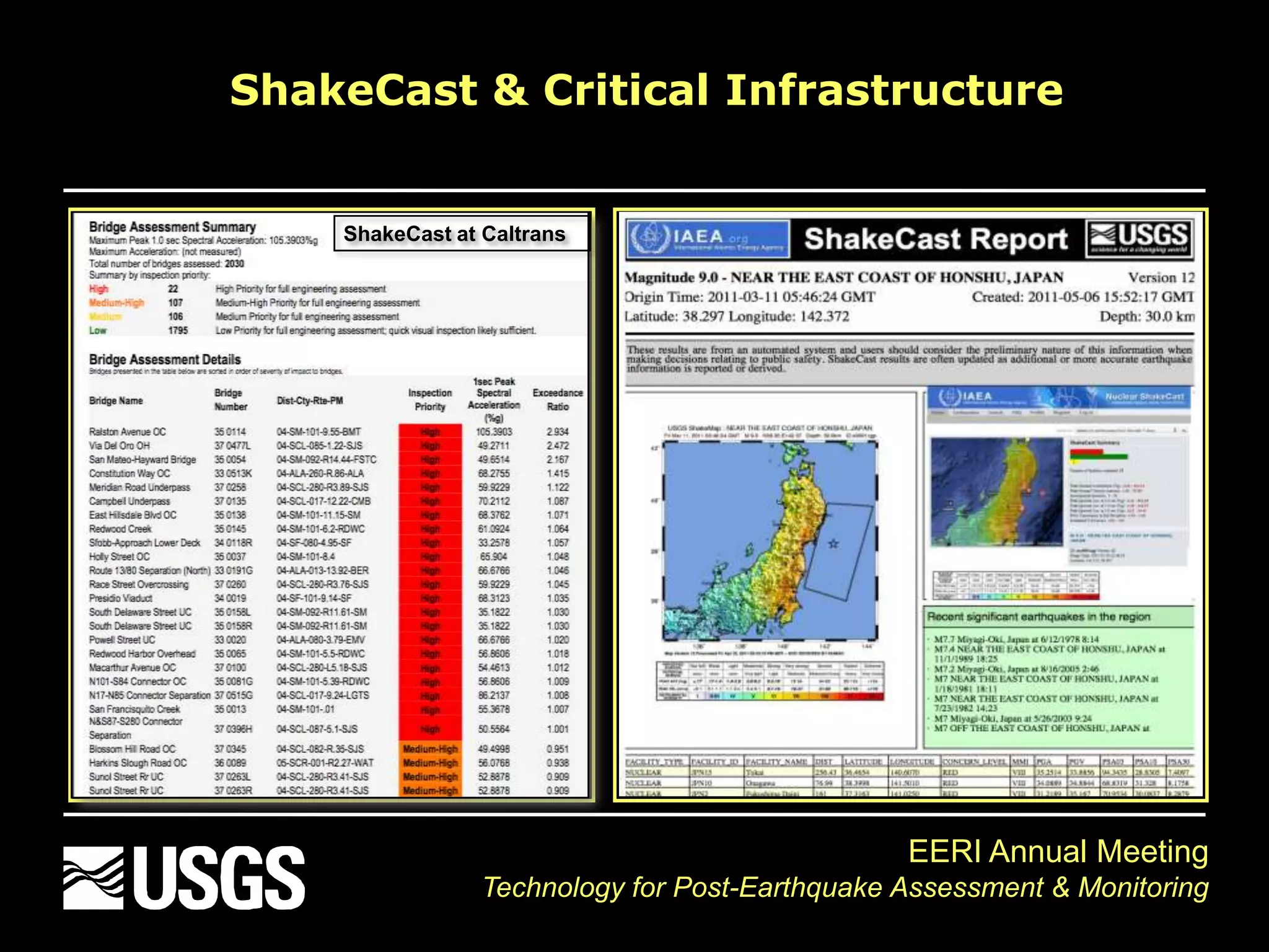
This document discusses post-earthquake impact assessment and response strategies. It describes using in-situ monitoring, ground-truthing, remote sensing, and estimating techniques like ShakeMap, ShakeCast and PAGER to evaluate earthquake impacts. It provides examples of ShakeCast being used by organizations like Caltrans and LAUSD to prioritize inspections of bridges and schools after earthquakes.


