FINDING THE EPICENTER ACTIVITY SHEET
•Download as DOCX, PDF•
1 like•1,962 views

A POWERPOINT RELATED TO THIS WAS ALSO UPLOADED.tHIS IS FOR GRADE 10 STUDENTS 1ST QAURTER

Recommended
Recommended
More Related Content
What's hot
What's hot (20)
Similar to FINDING THE EPICENTER ACTIVITY SHEET
Similar to FINDING THE EPICENTER ACTIVITY SHEET (20)
More from DARYL (MONKAYO NHS)
More from DARYL (MONKAYO NHS) (20)
Recently uploaded
Recently uploaded (20)
FINDING THE EPICENTER ACTIVITY SHEET
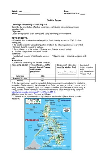
- 1. Avtivity no. _______ Date: ____ Name: ____________________ Grade & Section: ____ Find the Center Learning Competency: S10ES-Ia-j-36.1 Describe the distribution of active volcanoes, earthquake epicenters and major mountain belts Objective: Locate the epicenter of an earthquake using the triangulation method. KEY CONCEPTS: ->Epicenter is a point on the surface of the Earth directly above the FOCUS of an earthquake. -> To locate epicenter using triangulation method, the following data must be provided 1.At least three(3) recording stations 2. Time difference in the arrival of P-wave and S-wave in each station 3. Distance of epicenter from each station Materials: • hypothetical records of earthquake waves • Philippine map • drawing compass and ruler Procedure: 1. Fill in the table using the formula provided. Recording station Time difference in the arrival time of P-wave and S-wave (seconds) Distance of epicenter from the station (km) x Computed distance on the map Map distance(cm) =d/200 * 1.1 Batangas 44.8 Puerto Princesa 32 Davao 38.4 2. On the map below, use the computed distance on map in each station to locate the epicenter. Start measuring the distance from Batangas (orange dot) and form a circle using a drawing compass. If you don’t have a compass, you can draw a circle using a string,clip,etc. Watch here for a hack on how to draw a circle without using compass. https://www.youtube.com/watch?v=4EFA4YLSMHA 3.Do the same for puerto Princesa and Davao. Q1. Where is the epicenter of this hypothetical earthquake?(place where 3 circles intersect)
- 2. Q2. What difficulty will you encounter if you only have data from two recording stations? Q3. What is the distance of the epicenter from the seismic station? Q4. What do you think is the importance of determining the epicenter of an earthquake? Prepared by: DARYL F. CADANILLA