2. Introduction
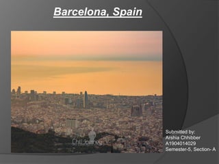
Barcelona is the capital
city of the autonomous
community of
Catalonia in the Kingdom
of Spain, as well as the
country's second most
populous municipality.
Total area covered by
Barcelona is 101.4
square kilometers.
It is a metropolitan city
with a population of
5,375,774.
It is a radial city, radial
around the old settlement
of Barcelona now known
as El Ribera.
4. History and evolution of
Barcelona
Barcelona during 1563’s
Montjuïc
In 1794, this fortress was used by the French astronomer Pierre François André Méchain for
observations relating to a survey stretching to Dunkirk that provided the official basis of the
measurement of a metre.
5. Plan of Barcelona according to Roman architecture
In about 15 BC, the Romans redrew the town as a castrum (Roman military camp)
centered on the "Mons Taber", a little hill near the contemporary city hall
The typically Roman grid plan is still visible today in the layout of the historical center,
the Barri Gòtic (Gothic Quarter)
10. District areas of Barcelona
It is one of the biggest districts
of Barcelona, situated on the north-
west of the city
Sarrià-Sant Gervasi
Today, Sarrià still retains a
village atmosphere, even in
the middle of Barcelona,
with narrow streets and small
houses.The main street of
Sarrià is Major de Sarrià
11. Sant Andreu -Its size is 653 ha. (third
district in size) and it had 142,598 inhabitants
in 2005. It is in the northern part of the city.
Sant Marti -It borders the Mediterranean
sea, and four other districts of the city
Sant Martí has a population of 221,029 (2005), which
makes it the second most populated district in
Barcelona
12. Horta-Guinardó is the name of one of the
districts of Barcelona, located in its North-Eastern
corner. It is named after two very heterogeneous
areas of the city, Horta and el Guinardó, which
together cover a large area of 11.92 km², which
sums up for the 11,9% of the total extension of the
city.
Nou Barris-It is located in the northern part
of the city adjacent to two other districts of
Barcelona: Sant Andreu and Horta-
Guinardó and grew up extensively out of small
urbanised areas
13. Les CortsIt is located in the western part of
the city.
It had 82.588 inhabitants in the 2005 census, which
makes it the least populous district of the city.
Gràcia is bordered by the districts of Eixample to the
south, Sarrià-Sant Gervasi to the west and Horta-
Guinardó to the east
14. Eixample: A area of Barcelona which was
designed in a grid frame, because of lack of good
road networks, this area was supposed to be
called the garden city of Barcelona.
Montjuic: Barcelona's Montjuïc is a broad
shallow hill with a relatively flat top overlooking
the harbour, to the southwest of the city centre.
19. •In a superblock, several city blocks are joined together, and traffic is re-routed around the outside.
• Inside, pedestrians and cyclists have priority on the road, while residents of the blocks can drive at a slow
speed.
•Neighborhoods that once had little green space will be filled with mini-parks and gardens.
22. Pedestrian Area
The city centre is
mainly for
pedestrian. Though
this is mainly due to
the old streets that
don't allow traffic,
many streets such
as Portal de
l'Àngel, allow
enough space for
tourists and locals