SlideShare a Scribd company logo
1 of 153
Download to read offline
B. te Brake
M.H.J. van Huijgevoort
January 2008
Hydrological characterization of
mangrove forests in Can Gio and
Ca Mau, Vietnam
MSc Thesis
Hydrology and Quantitative Water Management Group
Hydrological characterization of
mangrove forests in Can Gio and
Ca Mau, Vietnam
MSc Thesis Hydrology and Quantitative Water Management
HWM-80436
Bram te Brake
reg. no.: 840121 116 120
Marjolein van Huijgevoort
reg. no.: 840924 379 100
Wageningen University
Department of Environmental Sciences
Hydrology and Quantitative Water Management Group
Supervisors:
R. Dijksma
Hydrology and Quantitative Water Management Group,
Wageningen University
M.E.F. van Mensvoort
Land Dynamics Group, Wageningen University
Wageningen, January 2008
Photo on cover: mudflat in front of mangrove forest in Ca Mau, at low tide.
Abstract
Mangrove rehabilitation projects often fail to achieve their goals, because hydrological characteristics
of sites are not taken into account. This is partly because only one tool is available to asses the
relationship between hydrology and vegetation in mangrove forests. This tool is a hydrological
classification developed by Watson in 1928. In this hydrological classification Watson grouped
several mangrove species in five inundation classes based on tidal regime, elevation and flooding
frequency. After an exploratory research in Can Gio, Vietnam, Van Loon et al. (2007) proposed an
extended hydrological classification. The objective of the current study was verifying this extended
classification and testing it for a wider range of hydrological characteristics. Therefore during a
measuring campaign from March until May 2007 tidal regimes, elevation profiles, water levels,
vegetation, creek flow and groundwater flow were investigated in two study areas in southern
Vietnam; Can Gio and Ca Mau.
Both study areas have an irregular semi-diurnal tidal regime, but the diurnal component is stronger
in Ca Mau. The tidal amplitudes are much larger in Can Gio than in Ca Mau.
The elevation profiles showed ridges of a range of magnitudes in several directions and extensive
basins, indicating that micro-topography is abundantly present in the mangrove forest. This micro-
topography impedes overland flow, so at ebb tide water has to be discharged through slower flow
paths like creeks or groundwater. This leads to longer durations of inundations at the sites than
expected from their elevation.
The calculated hydraulic conductivities indicate that groundwater flow can occur in the mangrove,
especially when biopores are present.
Net discharge in mangrove creeks could not be calculated, because measurements were not done
over complete tidal cycles. Flow velocities showed a tidal asymmetry; ebb velocities were larger than
flood velocities.
Inundation characteristics of the measurement sites are determined from the measured water
levels. These inundation characteristics are used to assign inundation classes to the sites according to
the Watson and extended classification. The parameter flooding frequency in the Watson classification
leads to unrealistic results in areas with an irregular tidal regime. The extended classification gives
better results for areas with an irregular tidal regime and irregular elevation profiles, but still some
sites are not classified correctly.
During this research mixed zones with both Avicennia alba and Rhizophora apiculata were
observed. None of the inundation classes predicts a vegetation pattern with both these species.
Therefore a new hydrological classification is proposed with an extra class, 2*. The differences in
vegetation and hydrologic conditions in the mixed zone are emphasized by this extra class and sites
can be classified more accurately, especially in zones with a lot of variation in vegetation.
Since it yields unrealistic results, the parameter flooding frequency is omitted completely. The
new classification does not make a distinction between regular or irregular elevation profiles, which
makes it easier to use in forest management. For the measurement sites in both Can Gio and Ca Mau
the new classification resulted in better predictions of the inundation classes for the measurements
sites, although the areas have different tidal regimes and elevation profiles.
So, the new classification gives promising results for mangrove rehabilitation projects, because it
is suitable for different elevation profiles and tidal regimes and describes vegetation patterns in detail.
Keywords: Hydrology; Mangroves; Ecosystems; Hydrological classification; Mangrove restoration;
Mangrove rehabilitation; Vietnam.
Preface
This report is the result of about 9 months work for our MSc-thesis Hydrology and Water Quality,
specialization Hydrology and Quantitative Water Management. A thesis about mangrove forest
management could be expected in a study like Forest and Nature Conservation, but it was certainly not
the first thing we thought of when we started to look for a subject. A field campaign of 3 months in an
ecosystem we only knew from pictures and the practical relevance for mangrove management, were
two factors that made us decide to go for it. Our very limited knowledge of mangrove forests could be
regarded as a disadvantage, but we think it turned into an advantage since it made our work much
more interesting and challenging. Of course it was sometimes confusing as well, but we think we
managed quite well to stay focused and keep the work relevant.
The water dependency of mangroves and the complexity of hydrological processes that occur,
definitely offer very interesting opportunities for hydrologists to study. We encountered this during
our work in Can Gio and Ca Mau mangrove areas and the subsequent data analysis back in
Wageningen. The enormous amounts of articles, books and reviews about mangroves (and mangrove
hydrology) that are published emphasize this. It is difficult to tell which part of the work was hardest
for us. “Walking” through tick layers of mud, being far away from home and doing hardly anything
else than work, sometimes were unpleasant parts of the field campaigns. But, working for months
behind a computer in the rainy Netherlands and bringing all the information together might have been
even harder. However, the possibility of working in wonderful areas, the people we have met and all
the knowledge we have gained, do definitely counterbalance the side-effects.
The fact that one of our main sources of information was a book published in 1928, underlines the
economical, ecological and social values mangroves have and had. It also indicates the need for
research with up to date techniques, since information from 1928 might not be suitable for current
projects. Because of the importance of mangrove forest, we found it very inspiring to work on a tool
which can be used in mangrove management and rehabilitation projects.
There are a couple of people we want to thank for their contribution in our research. First of all, our
supervisors, Roel Dijksma and Tini van Mensvoort. To work with you both was a pleasure for us and
the conversations and discussions we had were very motivating. Tini, we might have been the last
students you supervised, and that certainly is a pity for all the other students after us. We also like to
thank our supervisor in Vietnam, Dr. V.N. Nam of Nong Lam University, Ho Chi Minh City. He was
of great help in introducing us to mangroves in general and the study areas in particular, arranging
research permissions and discussing some results with us. Furthermore, we thank Anne van Loon for
providing a lot of information and data, and her willingness to answer all our questions. Other people
who helped us during the fieldwork are the staff from the Can Gio Forestry Service, Can Gio Forestry
Park and Mui Ca Mau National Park. Special thanks to A. Kiet for his help on the recognition of
mangrove species in Can Gio and to Mr. No, who was very helpful in transporting us and our
materials in Ca Mau everyday. The same did Mr. Son in Can Gio, for even a longer time, for which we
are very grateful. Finally, but certainly not in order of importance, Bram wants to thank Marjolein for
the pleasant cooperation and company in the previous year. Marjolein wants to thank Bram for the
nice cooperation and all the good times we had during this research. Of course not everything went
very smoothly all of the time, but serious problems were absent, while serious fun was abundantly
present!
We hope that reading this report will please you, as a reader. But above all, we hope that our work can
contribute in management of mangrove forests and in successfully carrying out mangrove
rehabilitation and restoration projects.
Bram te Brake & Marjolein van Huijgevoort
Wageningen, January 2008.
Contents
1 INTRODUCTION........................................................................................................................................ 1
1.1 BACKGROUND ........................................................................................................................................ 1
1.2 OBJECTIVE OF THE RESEARCH ................................................................................................................ 2
1.3 RESEARCH QUESTIONS ........................................................................................................................... 2
1.3.1 Characterization of mangrove hydrology ......................................................................................... 2
1.3.2 Hydrological classification ............................................................................................................... 2
1.4 STRUCTURE OF THE REPORT ................................................................................................................... 2
1.5 DEFINITIONS........................................................................................................................................... 3
2 THEORY ...................................................................................................................................................... 5
2.1 INTRODUCTION....................................................................................................................................... 5
2.2 HYDROLOGY .......................................................................................................................................... 5
2.2.1 Tides.................................................................................................................................................. 5
2.2.2 River discharge ................................................................................................................................. 6
2.2.3 Meteorology ...................................................................................................................................... 6
2.2.4 Hydrology of mangrove forests......................................................................................................... 7
2.2.4.1 Surface water............................................................................................................................................ 7
2.2.4.2 Groundwater............................................................................................................................................. 7
2.3 MANGROVE ECOLOGY............................................................................................................................ 7
2.3.1 Mangroves......................................................................................................................................... 7
2.3.2 Zonation and succession ................................................................................................................... 9
2.3.3 The relation between hydrology and ecology.................................................................................... 9
2.4 REHABILITATION AND RESTORATION OF MANGROVE ECOSYSTEMS...................................................... 10
2.5 HYDROLOGICAL CLASSIFICATIONS....................................................................................................... 11
2.5.1 Watson hydrological classification ................................................................................................. 12
2.5.2 Disadvantages of the Watson classification.................................................................................... 12
2.5.3 Extended hydrological classification .............................................................................................. 13
3 SITE DESCRIPTION................................................................................................................................ 15
3.1 CAN GIO............................................................................................................................................... 15
3.1.1 History............................................................................................................................................. 15
3.1.2 Can Gio Man-and-the-Biosphere reserve ....................................................................................... 17
3.1.3 Tidal regime .................................................................................................................................... 17
3.1.4 Hydrology........................................................................................................................................ 17
3.1.5 Topography..................................................................................................................................... 17
3.1.6 Vegetation ....................................................................................................................................... 18
3.2 CA MAU ............................................................................................................................................... 19
3.2.1 History............................................................................................................................................. 19
3.2.2 Mui Ca Mau National Park............................................................................................................. 19
3.2.3 Tidal regime .................................................................................................................................... 20
3.2.4 Hydrology........................................................................................................................................ 20
3.2.5 Topography..................................................................................................................................... 20
3.2.6 Vegetation ....................................................................................................................................... 21
4 METHODOLOGY..................................................................................................................................... 23
4.1 SITE SELECTION.................................................................................................................................... 23
4.1.1 Selection criteria of the measurement plots .................................................................................... 23
4.1.2 Locations of the measurement plots................................................................................................ 23
4.2 TIDAL PREDICTIONS ............................................................................................................................. 25
4.3 METEOROLOGICAL DATA ..................................................................................................................... 25
4.4 WATER LEVEL ...................................................................................................................................... 26
4.4.1 Divers.............................................................................................................................................. 26
4.4.2 Analysis........................................................................................................................................... 27
4.4.3 Piezometer locations ....................................................................................................................... 29
4.5 ELEVATION .......................................................................................................................................... 32
4.5.1 Laser levelling................................................................................................................................. 32
4.5.2 Combination of laser levelling and water level data....................................................................... 34
Contents
4.5.3 Locations......................................................................................................................................... 34
4.6 VEGETATION ........................................................................................................................................ 34
4.7 CREEK FLOW ........................................................................................................................................ 34
4.7.1 Locations and tidal regime.............................................................................................................. 34
4.7.2 Cross-section................................................................................................................................... 35
4.7.3 Measurements ................................................................................................................................. 36
4.7.4 Calculations .................................................................................................................................... 36
4.8 HYDRAULIC CONDUCTIVITY................................................................................................................. 36
4.8.1 Description of the tests.................................................................................................................... 37
4.8.2 Equations ........................................................................................................................................ 37
4.8.3 Aquifer thickness............................................................................................................................. 39
5 RESULTS.................................................................................................................................................... 41
5.1 TIDAL REGIME...................................................................................................................................... 41
5.1.1 Can Gio........................................................................................................................................... 41
5.1.1.1 Tidal predictions Vung Tau.................................................................................................................... 41
5.1.1.2 Open water measurements...................................................................................................................... 41
5.1.2 Ca Mau............................................................................................................................................ 43
5.1.2.1 Tidal predictions Ha Tien and Dinh An.................................................................................................. 43
5.1.2.2 Open water measurements at C0 and D0................................................................................................ 45
5.2 METEOROLOGY .................................................................................................................................... 47
5.2.1 Air temperature and pressure ......................................................................................................... 47
5.2.2 Precipitation.................................................................................................................................... 47
5.3 ELEVATION .......................................................................................................................................... 48
5.3.1 Elevation measurement sites ........................................................................................................... 48
5.3.2 Elevation profiles Can Gio.............................................................................................................. 48
5.3.3 Elevation profiles Ca Mau .............................................................................................................. 52
5.4 WATER LEVEL MEASUREMENTS ........................................................................................................... 55
5.4.1 Can Gio........................................................................................................................................... 55
5.4.1.1 Plot A ..................................................................................................................................................... 55
5.4.1.2 Plot B...................................................................................................................................................... 56
5.4.1.3 Inundation characteristics....................................................................................................................... 57
5.4.2 Ca Mau............................................................................................................................................ 59
5.4.2.1 Plot C...................................................................................................................................................... 59
5.4.2.2 Plot D ..................................................................................................................................................... 60
5.4.2.3 Inundation characteristics....................................................................................................................... 61
5.5 VEGETATION ........................................................................................................................................ 62
5.5.1 Can Gio........................................................................................................................................... 62
5.5.1.1 Plot A ..................................................................................................................................................... 62
5.5.1.2 Plot B...................................................................................................................................................... 64
5.5.2 Ca Mau............................................................................................................................................ 65
5.5.2.1 Plot C...................................................................................................................................................... 65
5.5.2.2 Plot D ..................................................................................................................................................... 65
5.6 CREEK FLOW ........................................................................................................................................ 66
5.6.1 Can Gio........................................................................................................................................... 66
5.6.1.1 Creek profiles ......................................................................................................................................... 67
5.6.1.2 Flow velocity and water level................................................................................................................. 68
5.6.1.3 Discharge................................................................................................................................................ 69
5.6.2 Ca Mau............................................................................................................................................ 69
5.6.2.1 Creek profiles ......................................................................................................................................... 70
5.6.2.2 Flow velocity and water level................................................................................................................. 70
5.6.2.3 Discharge................................................................................................................................................ 73
5.7 HYDRAULIC CONDUCTIVITY................................................................................................................. 73
6 DISCUSSION ............................................................................................................................................. 75
6.1 TIDAL REGIME...................................................................................................................................... 75
6.1.1 Amplitude ........................................................................................................................................ 75
6.1.2 Diurnal vs. semi-diurnal ................................................................................................................. 75
6.2 ELEVATION .......................................................................................................................................... 75
6.3 WATER LEVEL MEASUREMENTS ........................................................................................................... 76
6.3.1 Time lag between measurement sites .............................................................................................. 76
6.3.2 Inundation characteristics............................................................................................................... 77
Contents
6.4 CREEK FLOW ........................................................................................................................................ 78
6.5 HYDRAULIC CONDUCTIVITY................................................................................................................. 81
7 HYDROLOGICAL CLASSIFICATIONS............................................................................................... 85
7.1 RESULTS EXISTING HYDROLOGICAL CLASSIFICATIONS......................................................................... 85
7.2 ERRORS AND UNCERTAINTIES IN EXISTING CLASSIFICATIONS............................................................... 88
7.3 NEW HYDROLOGICAL CLASSIFICATION................................................................................................. 90
7.4 APPLICATION OF THE NEW HYDROLOGICAL CLASSIFICATION ............................................................... 91
8 CONCLUSIONS......................................................................................................................................... 95
8.1 CONCLUSIONS CHARACTERIZATION OF MANGROVE HYDROLOGY ........................................................ 95
8.2 CONCLUSIONS HYDROLOGICAL CLASSIFICATION.................................................................................. 95
9 RECOMMENDATIONS........................................................................................................................... 97
10 REFERENCES....................................................................................................................................... 99
APPENDICES
APPENDIX A ABSTRACTS EARLIER RESEARCH
APPENDIX B COORDINATES OF THE PIEZOMETER LOCATIONS
APPENDIX C TIDAL PREDICTIONS
APPENDIX D GRAPHS OF THE WATER LEVELS
APPENDIX E VEGETATION
APPENDIX F LOCATIONS DISCHARGE MEASUREMENTS
APPENDIX G GRAPHS OF THE PERMEABILITY TESTS
APPENDIX H VERIFICATION OF THE NEW CLASSIFICATION
List of figures
2.1 THE LUNAR PHASE EFFECT, RESULTING IN SPRING AND NEAP TIDE PERIODS ...................................................... 5
2.2 COMMON PROJECTION OF THE EARTH’S ORBITAL PLANE AROUND THE SUN AND THE MOON’S ORBITAL PLANE
AROUND THE EARTH........................................................................................................................................ 6
2.3 EXAMPLE OF A PROFILE DIAGRAM OF A TIDAL FLAT IN NORTHERN AUSTRALIA................................................. 9
2.4 NURSERY OF MANGROVE SEEDLINGS IN THAILAND. ........................................................................................ 11
2.5 TIDAL PREDICTION FOR THE PORT OF VUNG TAU FOR THE PERIOD 28 APRIL TO 3 MAY 2004 WITH THREE
IMAGINARY SURFACE LEVELS. ...................................................................................................................... 13
3.1 LOCATION OF CAN GIO AND CA MAU; ZOOMING IN FROM THE WORLD TO SOUTHEAST ASIA AND TO SOUTHERN
VIETNAM. ..................................................................................................................................................... 16
3.2 MAP OF THE CAN GIO BIOSPHERE RESERVE..................................................................................................... 18
3.3 MAP OF THE SOUTHERN PART OF CA MAU PROVINCE. ..................................................................................... 20
4.1 LOCATIONS OF THE MEASURING PLOTS IN CAN GIO......................................................................................... 24
4.2 LOCATIONS OF THE MEASURING PLOTS IN CA MAU. ........................................................................................ 25
4.3 LOCATIONS OF THE TIDAL STATIONS, METEOROLOGICAL STATIONS AND STUDY AREAS. ................................. 26
4.4 A STANDARD DIVER. ........................................................................................................................................ 26
4.5 PIEZOMETER IN THE FOREST AT FLOOD TIDE. ................................................................................................... 27
4.6 DIVER IN A STILLING WELL .............................................................................................................................. 28
4.7 WATER LEVEL MEASUREMENT BY A DIVER...................................................................................................... 29
4.8 LOCATIONS OF THE PIEZOMETERS IN PLOT A. .................................................................................................. 30
4.9 LOCATIONS OF THE PIEZOMETER IN PLOT B. .................................................................................................... 31
4.10 LOCATIONS OF THE PIEZOMETERS IN PLOT C................................................................................................. 31
4.11 LOCATIONS OF THE PIEZOMETERS IN PLOT D.................................................................................................. 32
4.12 CONCEPT OF THE LASER LEVELLING METHOD ................................................................................................ 33
4.13 PHOTOGRAPH OF THE LASER LEVELLING EQUIPMENT ON A TRIPOD................................................................ 33
4.14 CALCULATION OF THE CROSS SECTIONAL AREA A. ........................................................................................ 35
4.15 PHOTOGRAPH OF THE SET UP USED TO MEASURE HYDRAULIC CONDUCTIVITY. .............................................. 37
5.1 PREDICTED WATER LEVELS AT THE PORT OF VUNG TAU; A) 3 TO 24 MARCH 2007, B) 24 MARCH TO 14 APRIL
2007, C) 14 APRIL TO 5 MAY 2007, D) 5 MAY TO 27 MAY 2007 ................................................................... 42
5.2 COMPARISON OF PREDICTED WATER LEVELS FOR VUNG TAU AND MEASURED WATER LEVELS IN DONG TRANH
RIVER FOR THE PERIOD 11 APRIL TO 18 APRIL 2007..................................................................................... 43
5.3 PREDICTED WATER LEVELS AT A) HA TIEN AND B) DINH AN, FROM 21 APRIL TO 20 MAY 2007 ..................... 44
5.4 OPEN WATER MEASUREMENTS AT SITE C0 AND D0 FROM 21 APRIL TO 20 MAY 2007. .................................... 46
5.5 DETAIL OF PREDICTED WATER LEVELS AT HA TIEN AND DINH AN AND MEASURED WATER LEVELS AT SITE D0
FOR THE PERIOD 23 APRIL TO 28 APRIL 2007................................................................................................ 46
5.6 MEASURED PRECIPITATION AT CAN GIO AND NAM CAN WEATHER STATIONS FROM 1 MARCH TO 22 MAY 2007
(AFTER: SOUTHERN REGIONAL HYDROMETEOROLOGICAL CENTER, 2007) AND OBSERVED RAINFALL EVENTS
AT MUI CA MAU........................................................................................................................................... 47
5.7 LOCATIONS OF THE LASER LEVELLING TRANSECTS IN PLOT A.......................................................................... 49
5.8 LOCATIONS OF THE LASER LEVELLING TRANSECTS IN PLOT B.......................................................................... 49
5.9 ELEVATION PROFILES IN PLOT A; A) PROFILES PERPENDICULAR TO THE MAIN CHANNEL (TOP), B) PROFILES
PARALLEL TO THE MAIN CHANNEL (BOTTOM).. ............................................................................................. 50
5.10 ELEVATION PROFILES IN PLOT B. ................................................................................................................... 51
5.11 LOCATIONS OF THE LASER LEVELLING TRANSECTS IN PLOT C........................................................................ 53
5.12 LOCATION OF THE LASER LEVELLING TRANSECT IN PLOT D. .......................................................................... 53
5.13 ELEVATION PROFILES IN PLOT C; A) PROFILES PERPENDICULAR TO THE MAIN CHANNEL (TOP), B) PROFILE
PARALLEL TO THE MAIN CHANNEL (BOTTOM).. ............................................................................................. 54
5.14 ELEVATION PROFILE IN PLOT D PERPENDICULAR TO MAIN CHANNEL............................................................. 55
5.15 DETAIL OF WATER LEVELS IN PLOT A FROM 21 MARCH 13:00 TO 22 MARCH 13:00, 2007............................. 56
5.16 DETAIL OF WATER LEVELS IN PLOT B AND AT A0 FROM 16 APRIL 21:00 TO 17 APRIL 6:00, 2007.................. 57
5.17 DETAIL OF WATER LEVELS AT SITE C1 AND THE ARTIFICIAL SURFACE LEVEL LINE ON 2 CM +SURFACE......... 58
5.18 DETAIL OF WATER LEVEL AND THE APPARENT SOIL SURFACE AT SITE A3...................................................... 59
5.19 DETAIL OF WATER LEVELS IN PLOT C FROM 17 MAY 9:00 TO 18 MAY 9:00, 2007. ........................................ 60
5.20 DETAIL OF WATER LEVELS IN PLOT D FROM 22 APRIL 12:00 TO 23 APRIL 6:00, 2007.................................... 61
5.21 OVERVIEW OF OBSERVED VEGETATION ZONES IN PLOT A.............................................................................. 62
5.22 MIXED ZONE WITH SHRUB LAYER AT THE NORTH BORDER OF TRANSECT 6. ................................................... 63
5.23 A. ALBA AND R. APICULATA DOMINATED MIXED ZONE WITH C. TAGAL......................................................... 64
5.24 SOLITARY A. ALBA IN THE DENSE R. APICULATA PLANTATION IN PLOT B...................................................... 64
5.25 CUT R. APICULATA STRIP IN PLOT C. YOUNG TREES CAN BE SEEN AT THE OPEN SPOTS.................................. 65
List of figures
5.26 VEGETATION IN PLOT D WITH A. ALBA, R. APICULATA AND B. PARVIFLORA................................................. 66
5.27 CREEK PROFILES IN CAN GIO: PLOT A (LEFT) AND PLOT B (RIGHT)................................................................ 67
5.28 EXAMPLES OF THE VARIETY OF DISCHARGE MEASUREMENT LOCATIONS; CREEK II, LOCATION 1 (LEFT) AND
CREEK VI, LOCATION 6 (RIGHT). ................................................................................................................... 68
5.29 VELOCITY AND WATER LEVELS AT LOCATION 1 AND WATER LEVELS AT SITE A0; 18 MARCH 2007 (LEFT),
28 MARCH 2007 (RIGHT)............................................................................................................................... 69
5.30 CREEK PROFILES IN CA MAU: PLOT C (LEFT) AND PLOT D (RIGHT)................................................................ 70
5.31 WATER LEVELS AT SITE C0 ON 30 APRIL AND 1 MAY 2007 (LEFT) AND AT SITE D0 ON 3 MAY 2007 (RIGHT).71
5.32 FLOW VELOCITY AND WATER LEVELS AT LOCATION 1 ON 30 APRIL 2007 AND LOCATION 2 ON 1 MAY 2007. 72
5.33 FLOW VELOCITY AND WATER LEVELS AT LOCATION 3 AND 4 ON 3 MAY 2007............................................... 72
5.34 DISCHARGE AT LOCATION 1 (30 APRIL), LOCATION 2 (1 MAY), LOCATION 3 (3 MAY) AND LOCATION 4 (3
MAY). ........................................................................................................................................................... 73
6.1 EXAMPLE OF A PARABOLIC VERTICAL VELOCITY PROFILE IN OPEN CHANNELS................................................. 79
6.2 SHIFT IN NEAR BED AND NEAR-SURFACE VELOCITIES AT THE TRANSITION FROM EBB TO FLOOD TIDE.............. 80
6.3 EXAMPLE OF A PARABOLIC HORIZONTAL VELOCITY PROFILE IN OPEN CHANNELS............................................ 80
6.4 EXPECTED HYDRAULIC CONDUCTIVITY PROFILE IN MANGROVE SOILS INTERSECTED BY BIOPORES.................. 82
7.1 RELATION BETWEEN INUNDATION CLASS AND GROWING CONDITIONS FOR 4 SPECIES...................................... 89
List of tables
2.1 WATSON’S HYDROLOGICAL CLASSIFICATION................................................................................................... 12
2.2 EXTENDED HYDROLOGICAL CLASSIFICATION................................................................................................... 14
4.1 PIEZOMETER LOCATIONS, DISTANCES TO MAIN CHANNEL AND MEASURING PERIOD......................................... 30
5.1 MEASURED TEMPERATURE DATA IN CAN GIO AND CA MAU. .......................................................................... 47
5.2 ELEVATION OF ALL MEASUREMENT SITES. ....................................................................................................... 48
5.3 AVERAGE TIME LAG AND DISTANCE TO DONG TRANH RIVER FOR PIEZOMETER SITES IN PLOT A. .................... 55
5.4 INUNDATION CHARACTERISTICS FOR PLOT A AND B. ....................................................................................... 58
5.5 AVERAGE TIME LAG AND DISTANCE TO RANG ONG LINH RIVER FOR PIEZOMETER SITES IN PLOT C................. 59
5.6 AVERAGE TIME LAG AND DISTANCES TO CUA LON RIVER FOR PIEZOMETER SITES IN PLOT D........................... 60
5.7 INUNDATION CHARACTERISTICS FOR PLOT C EN D........................................................................................... 61
5.8 OVERVIEW OF DISCHARGE MEASUREMENTS IN CAN GIO. ................................................................................ 67
5.9 MAXIMUM FLOW VELOCITIES IN CREEKS IN CAN GIO. ..................................................................................... 69
5.10 OVERVIEW OF DISCHARGE MEASUREMENTS IN CA MAU................................................................................ 70
5.11 CALCULATED K-VALUES FOR ALL PLOTS........................................................................................................ 74
7.1 INUNDATION CLASSES ATTRIBUTED TO THE MEASUREMENT SITES USING THE WATSON CLASSIFICATION........ 86
7.2 INUNDATION CLASSES ATTRIBUTED TO THE MEASUREMENT SITES USING THE EXTENDED CLASSIFICATION OF
VAN LOON ET AL. (2007)............................................................................................................................... 87
7.3 DIFFERENCES BETWEEN EXPECTED AND CALCULATED INUNDATION CLASSES ................................................. 88
7.4 NEW HYDROLOGICAL CLASSIFICATION AND THE SOUTHEAST ASIAN MANGROVE SPECIES ATTRIBUTED TO
EACH CLASS. ................................................................................................................................................. 92
7.5 INUNDATION CLASSES ATTRIBUTED TO THE MEASUREMENT SITES USING THE NEW CLASSIFICATION OF
TABLE 7.4. .................................................................................................................................................... 93
1
1 Introduction
1.1 Background
Mangrove forests occur in sub-tropical and tropical regions around the world (Alongi, 2002). There
are about seventy known mangrove species, which are all tolerant to salt and brackish waters (Field,
1998). The total area occupied by mangroves globally is difficult to determine, but is estimated to be
between 181 000 and 198 800 km2
in 1997 by Spalding et al. (in Field, 1998). Mangrove ecosystems
are highly productive, but also very vulnerable (Tabuchi, 2003). According to Alongi (2002)
“approximately one third of the mangrove forests over the world have been lost in the past 50 years”.
However Kairo et al. (2001) report that “less than 50% of the original total cover of mangroves” has
remained. The losses of mangroves can be contributed to the fact that they are heavily exploited, since
mangroves are highly productive ecosystems. The main threats for mangroves are overexploitation of
the natural resources, deforestation, conversion to aquaculture and salt-ponds, mining, pollution and
industrial or urban development (Field, 1998, Alongi, 2002). Natural disasters like tropical cyclones
(Tri et al., 1998) and the tsunami of 26 December 2004 in Asia, can also devastate mangrove
ecosystems (Barbier, 2006, Van Loon et al., 2006).
Mangroves are valuable ecosystems that provide a natural barrier against storms, stabilize
coastlines and have a high economical value for humans, who depend on their natural resources (Hong
and San, 1993). Therefore rehabilitation and restoration projects are carried out all over the world to
prevent further degradation and losses of mangrove areas. Rehabilitation is defined by Field (1998) as
“partially or fully replacing structural or functional characteristics of an ecosystem”. Field emphasizes
that ecological rehabilitation may also hold substitution of the disturbed or degraded state to a
situation of alternative characteristics than those originally present, as long as these alternative
characteristics have more social, economic or ecological value. Restoration on the other hand is
described by Field as “bringing an ecosystem back into its original condition”. Rehabilitation projects
in general have three main objectives: conservation of a natural system and landscaping, sustainable
production of natural resources and protection of coastal areas (Barbier, 2006, Field, 1998).
Unfortunately in mangroves many of these rehabilitation projects fail to achieve their goals or
result in mono-specific plantations, which can not be seen as successful ecological restoration (Lewis,
2001). The failure of these projects is often caused by lack of adequate site selection (Ellison, 2000)
and no determination of characteristics of the sites (Lewis, 2005). Especially the hydrological
characteristics of sites are often not taken into account. For example, in Vietnam Rhizophora apiculata
has been planted on mudflats in front of the forest, where this species can not survive partly due to the
wet conditions. According to Lewis (2001) “the single most important factor in designing a successful
mangrove restoration project is determining the normal hydrology (depth, duration and frequency of
tidal flooding) of existing natural mangrove plant communities”. The influence of hydrology on the
mangrove ecosystem is also recognized by Hughes et al. (1998), who mention it as a “key
determinant” for several processes, and by Field (1998), who states that “hydrology of the site is of
great importance”. However, little research is undertaken to quantify the relation between hydrology
and vegetation.
In 1928, Watson developed a hydrological classification in which he grouped the main mangrove
species in five inundation classes based on tidal regime, elevation and flooding frequency. In this way
he described the distribution of mangrove species near Port Swettenham at the Malay peninsula
(Watson, 1928). This classification is often used in rehabilitation projects (Hong and San, 1993,
Lewis, 2005, Van Loon, 2005), because no other general hydrological tool is available. Nam (2007)
however stated that the classification is not used anymore, since it does not describe hydrological site
characteristics well. After an exploratory hydrological research in Can Gio, Van Loon et al. (2007)
also concluded that the Watson classification gave unsatisfactory results in this area (Appendix A).
The classification was found to be unsuitable for regions with an irregular elevation profile and/or an
irregular semi-diurnal tidal regime. Therefore Van Loon et al. developed an extended hydrological
classification for regions with regular as well as irregular elevation profiles and tidal regimes. The
main parameter added in the extended classification is duration of inundation. This classification gave
better results for the Can Gio area (Van Loon et al., 2007). With this extended classification mangrove
rehabilitation projects might be more successful in the future.
1 Introduction
2
1.2 Objective of the research
The development of this extended classification gave rise to further research of the interaction between
hydrology and vegetation occurrence in mangrove areas, to increase the number of successful
rehabilitation and restoration projects. Therefore the main objective of this study is to verify the
extended Watson classification, as is proposed by Van Loon et al. (2007), and to test the applicability
of this classification for a wider range of hydrological characteristics.
Since the extended classification is based on relatively short data series and limited measuring
locations, only some sites in Can Gio, this study focuses on extending the existing data series in Can
Gio and on testing the classification in a mangrove area with different hydrological characteristics. In
this research field campaigns have been carried out in Can Gio and Ca Mau, both located in southern
Vietnam. This study is divided in two main sections. First, the general hydrological characteristics of
the study areas are investigated. Furthermore the hydrological classification is tested using these
characteristics, to determine its suitability for different areas.
1.3 Research questions
1.3.1 Characterization of mangrove hydrology
For the first part, investigating general hydrological characteristics in the study areas, the central
question is:
What are the hydrological characteristics of the research areas, with respect to the
tidal regime and flow patterns and how do these characteristics change in time?
To answer this question the following sub-questions are formulated and answered for each area:
- What is the tidal regime in the area and what are the differences within each of the areas?
- What is the flow pattern in the area and how does this change over time?
- How can the groundwater flow of the mangrove forest be characterized?
1.3.2 Hydrological classification
The central question of the part of the research focusing on the applicability of the extended
classification is:
Is there a consistent relation between hydrological characteristics and mangrove
development and can this lead to an extended Watson classification?
Sub-questions formulated with this question are:
- What are the differences with respect to the factors frequency and duration of tidal inundation
within a transect and between transects on different locations?
- What are the interactions of the elevation, tidal regime and the groundwater flow with the
dynamics of the mangrove vegetation along a transect?
1.4 Structure of the report
The different chapters in this report are mentioned and shortly described below.
Chapter 2 Theory; gives a description of mangrove ecosystems in general, the vegetation within
mangroves and the role of hydrology, based on literature. The hydrological classifications of both
Watson (1928) and Van Loon et al. (2007) are described in this chapter.
Chapter 3 Site description; contains information about the two different study areas. The history,
hydrology and vegetation in both areas are treated based on literature research.
Chapter 4 Methodology; presents all the methods of the measurements carried out in the mangrove
forest during this research.
1.5 Definitions
3
Chapter 5 Results; describes the results of the measurements carried out during this research which
are aimed at determining the hydrological characteristics of the study areas.
Chapter 6 Discussion; explains parts of the results in more detail. It discusses connections between
different observations within this research and between these observations and results of other
research available from literature.
Chapter 7 Hydrological classifications; discusses the results of the hydrological classifications of
Watson and Van Loon et al. obtained from the measured hydrological characteristics. A new
hydrological classification is proposed.
Chapter 8 Conclusions; gives the conclusions of both the characterization of mangrove hydrology and
the hydrological classifications.
Chapter 9 Recommendations; indicates possibilities for further research.
The appendices contain additional data obtained from the measurements during this research, a list of
optimum requirements of several mangrove species with regard to soil-type and frequency of
inundation, a list of measurement locations and additional information.
1.5 Definitions
The word ‘mangrove’ has several definitions in literature. It is both used to refer to “the constituent
plants of tropical intertidal forest communities or to the community itself” (Tomlinson, 1986). In this
report the word ‘mangrove’ refers to the community, so ‘mangrove forest’ and ‘mangrove’ are used in
the same way. The definition of mangrove forest as given by the Joint Group of Experts of the
Scientific Aspects of Marine Environmental Protection of IMO/UNESCO/WMO/WHO/IAEA/UN/
UNEP is used in this report. This group defines a mangrove forest as (European environment agency
glossary, 2007):
“A community of salt-tolerant trees and shrubs, with many other associated
organisms, that grows on some tropical and sub-tropical coasts in a zone roughly
coinciding with the intertidal zone.”
The individual species within the mangrove forest are referred to by their scientific name.
Abbreviations are used for the most common species in this report. The genus Rhizopora is
abbreviated to R., Avicennia to A., Bruguiera to B. and Ceriops to C., the species names are not
abbreviated. So for example the species Bruguiera parviflora becomes B. parviflora and Rhizophora
apiculata is written as R. apiculata. The annex spp. is used to indicate several species of the same
genus together, like Rhizophora spp.. When the different vegetation zones are described the
abbreviations Rh and Av refer to the Rhizophora zone and Avicennia zone.
For the analysis of the data from the measurements several equations are needed. Together with
the definition of the parameters in these equations the dimensions in which the parameters should be
expressed are given, instead of units. These dimensions are notated between square brackets. So the
dimension length of a parameter is displayed with [L], which can be centimetres, metres or kilometres.
The same applies to [T], which is the notation for the dimension time.
1 Introduction
4
5
2 Theory
2.1 Introduction
This report discusses a research on the relation between hydrology and ecology of mangrove forest.
Therefore, some background information might be needed on the hydrology of mangrove forests, the
ecology of mangrove forests or the connection between these two. In this chapter an overview of
relevant topics in these subjects is given.
Van Loon (2005) incorporated a literature study on mangrove hydrology and ecology in her study
on water flow and tidal influence in Can Gio. The paragraphs 2.2, 2.2.2, 2.2.3, 2.2.4, 2.3.3 are mainly
based on this literature study. The complete literature study of Van Loon can be found in Van Loon
(2005).
2.2 Hydrology
According to Hughes et al. (1998) the hydrology is a key determinant in species distribution, wetland
productivity and nutrient cycling and availability in mangrove systems. Therefore studying the
hydrology in a mangrove-delta system has a high priority. Hydrological research in mangrove systems
is done by, among others, Wolanski (1980 to 1992), Mazda (1990 to 2006), Hughes (1998) and
Kitheka (1997). In tropical coastal waters the main forcing factors for the coastal hydrology are the
tide, river discharge and meteorology (Kitheka, 1997), which interact in different ways.
2.2.1 Tides
Tide is the phenomenon of periodic sea level rise and fall. Tidal water movements, both horizontal
(flow velocity) and vertical (water level), are caused by a complex interaction of astronomical forces
and hydrodynamic effects of the ocean bottom topography and the coastal configuration. The
astronomical forces relevant in the generation of tides are mainly the attractive power of the moon and
the sun. During the 29.53 day’s cycle of the moon around the earth, the gravitational attraction of
moon and sun may variously act along a common line or at different angles (Figure 2.1).
Figure 2.1 The lunar phase effect, resulting in spring and neap tide periods (Center for Operational
Oceanographic Products and Services, 2005).
This lunar phase shift results in an alternation of higher (spring tide) and lower (neap tide) than
average tidal range over approximately 2 weeks. Next to this, both the moon and the earth revolve in
elliptical orbits and consequently the distances between the sun and the earth and the moon and the
earth vary (Figure 2.2). Increased tide-raising forces are produced when the moon is at position of
perigee, its closest position to the earth (once each month), or the earth is at perihelion, its closest
2 Theory
6
position to the sun (once each year, around 2 January). Figure 2.2 shows the situation of perigee
coinciding with perihelion. In this situation tides of increased range are generated. On the other hand
considerably reduced tidal ranges occur when apogee, aphelion, and the first- or third-quarter moon
coincide at approximately the same time. In general, tidal forces are mainly induced by the moon,
since solar tide generating effects are smaller than the lunar effect. (Center for Operational
Oceanographic Products and Services, 2005)
Figure 2.2 Common projection of the earth’s orbital plane around the sun and the moon’s orbital plane around
the earth (Center for Operational Oceanographic Products and Services, 2005).
The varying interaction of astronomical forces and hydrodynamic effects results in different tidal
regimes between different regions. Tidal regimes are characterized by the amplitude and the frequency
of the tides. In coastal seas the bathymetry has a large influence on the tidal regime. A coastal sea is
usually relatively shallow leading to an increase in tidal wave height (Rijn, 1990, in Van Loon, 2005).
Tidal regimes are often classified as diurnal, semi-diurnal and mixed, based on the frequency of
high and low water levels. There are however no sharply defined limits separating the groups. In
general, the tide is said to be diurnal when both high tide and low tide occur only one time each day
during the greater part of the month. The tide is semi-diurnal when two high and two low tides occur
each day with approximately the same amplitude. In mixed tidal regimes the diurnal and semi-diurnal
components are both important factors and the tide is characterized by large variations in high and/or
low water levels. There will usually be two high and two low waters each day, but occasionally the
tide will become diurnal. Therefore these tidal regimes are called irregular semi-diurnal. (Voigt, 1998)
2.2.2 River discharge
In delta areas the tidal wave from the coastal sea enters the creek system. In this region the tides
experience the influence of the discharge of river water through the creeks, generally in the direction
of the sea, although different flow routes may be determined by the magnitude of the discharge, the
tidal regime, the configuration of the creeks, and possible hydrological obstructions.
2.2.3 Meteorology
River discharge depends on precipitation and losses of water, mainly evapotranspiration, in the river
basin. Major rainfall events, which occur in tropical regions during only one season, are highly
significant for flow patterns, but have only a short-term effect on water levels (Hughes et al., 1998).
Furthermore, wind has an influence on the water movement in a delta region. Wind influences the tidal
regime through possible dampening and amplifying effects, and the direction of the wind can affect
the water distribution in the creek system.
2.3 Mangrove ecology
7
2.2.4 Hydrology of mangrove forests
2.2.4.1 Surface water
According to Mazda et al. (1997) “reports on mangrove hydrodynamics are largely restricted to the
tidal creeks, and measurements in the swamp itself are sparse”. Water that reaches a tidal flat occupied
by mangrove forest by overland flow, behaves differently than creek water due to the presence of
vegetation and the limited water depth. Due to bottom friction large vertical shear exists, which might
result in low flow velocities or even stagnant water. Mazda et al. (1997) carried out hydrodynamic
measurements in a mangrove swamp and presented observations of the drag force due to vegetation on
tidal currents through mangrove swamps.
Tidal regime and elevation are not the only factors determining the frequency, duration and height
of inundation of a tidal flat. Topography and vegetation at the tidal flat have a significant influence on
the duration (Van Loon et al., 2007) and frequency of inundation. In the wet season higher
precipitation and river discharge can cause the water at high tide to flood a larger area than in the dry
season (Thom et al., 1975).
With strong tidal currents, as during spring tide, the tidal influence is the dominant water
transporting process in the mangrove swamp and groundwater flow does not contribute much to
hydrodynamics (Wolanski, 1992). However, during neap tide the groundwater movements can become
an important factor in the mangrove hydrology.
2.2.4.2 Groundwater
As the topography of a delta region is flat and a large area of land is frequently flooded, groundwater
levels are usually very high. Groundwater behaviour is controlled by a combination of effects of tidal
processes, precipitation and evapotranspiration and possibly regional groundwater flow (Hughes et al.,
1998). Depending on the location in the delta, the distance to open water and the period of the year,
the tidal regime or the meteorological variables are the most important. According to Hughes et al.
(1998) the tidal forcing is the dominant mechanism for pore water movement in the saturated and
intertidal zone of a delta. Close to the creek water table movement is directly coupled to fluctuations in
water level of the creek and thus of the tidal movements. With increasing distance from the creek the
fluctuations in groundwater level rapidly decline. At a distance of 5 to 10 m from the creek the water
table movement is negligible. Consequently, at the inland parts of the mangrove swamp
evapotranspiration is the only way groundwater levels can be lowered. In the wet season fluctuations
in groundwater level are considerable due to the irregular character of the rainfall if the area is not
flooded for a long period. During the dry season the water table will drop gradually due to the
increasing evapotranspiration in case of no replenishment. The latter situation results in a high
groundwater salinity. At some inland locations mangrove trees are not able to survive and a salt marsh
with specific salt-tolerant vegetation will develop (Hughes et al., 1998).
2.3 Mangrove ecology
2.3.1 Mangroves
Mangroves are forests consisting of a group of salt-tolerant trees and shrubs that can develop along
sub-tropical and tropical coasts. They develop best along sheltered coastlines and in delta regions
where waves are broken. In sheltered estuaries and lagoons mangroves are usually extensive and may
stretch up to several kilometres inland, with a gradual transition to terrestrial vegetation (Tomlinson,
1986). Mangroves grow along rivers and creeks as long as there is tidal movement and the water is salt
or brackish (Poorter and Bongers, 1993, in Van Loon, 2005). The distribution of mangroves is divided
in two groups by several authors (Chapman, 1976, Duke et al., 1998, Tomlinson, 1986), which are the
Eastern and Western mangroves. Here the names of the groups indicate the hemisphere on which the
species are found, but other names are also mentioned in literature. The total number of true mangrove
2 Theory
8
species1
in the Eastern group, including East Africa, India, southeast Asia, Australia and the Western
Pacific, is 40. In the Western group only eight true mangroves species are found. (Tomlinson, 1986)
Composition of the groups not only differs in number, but also in species; no species is present in both
groups. Mangroves in Vietnam are part of the Eastern group. The southeast Asian sub-region is
recognised as the biogeographical province supporting the most diverse mangroves in the world. The
highest diversity of mangrove plant species has been recorded in this sub-region (Tri et al. 2000).
Mangrove forests are frequently inundated by tides, which is a primary existence factor for many
of its species. Mangrove trees however perform best under fresh water conditions, but they loose
competition with other species in fresh water environments. Due to specific physiological adaptations
in their tissue, mangrove trees can survive in saline and brackish water environments and under
anaerobic conditions which occur during moments of inundation. These adaptations make mangrove
families an unique group of trees and plants that are able to survive along coastlines, which form an
inaccessible habitat for other species. Adaptations to tidal inundations and saline water are not the only
characteristic features of mangrove species. Mangroves have to cope with variable water levels,
unstable soils, salinity of the water leading to physiological dryness, lack of oxygen, water flow etc.
(Van Loon, 2005).
Tomlinson (1986) reports a list of major features that are typical for all or most of the mangroves
species:
1. Complete restriction to the mangrove environment; they occur only in mangrove forest and do
not extend into terrestrial communities.
2. A major role in the structure of the community and the ability to form pure stands.
3. Morphological specialization that adapts mangroves to their environment; the most obvious
being aerial roots and vivipary of the seed.
4. Some physiological mechanism for salt excretion which enables mangroves to grow in saline
water.
5. Mangrove species are separated from their relatives at least at the generic level and often at
the subfamily or family level.
Especially criterion 1 and the vivipary of seed are very distinctive. Many mangrove species have
special roots, called pneumatophores. These roots enable the trees to get some air, during shallow
inundations and in water saturated soils. Aerial roots are often regarded as the main feature of
mangrove species, but many other forest swamp plants develop aerial roots as well (Tomlinson, 1986).
Mangrove seeds develop on the parent tree and grow out into propagules, which are viviparous. When
released from the parent tree they might be transported by water movements or settle near the parent
tree. Most mangrove species have propagules that float on water. The establishment of propagules
depends on the number of days propagules remain buoyant and viable, the strength of surface currents,
the water conditions, and the availability of suitable sites (Duke et al., 1998). Suitability of sites is
determined by the depth of inundation, the presence of other mangrove trees and the salinity of the
water (Van Loon, 2005). Vanspeybroeck (1992) found that mangrove seedlings in Kenya are restricted
to sites where their parent trees are found, even when parental trees have been felled. This can be due
to a poor dispersal of propagules or the presence of suitable environmental conditions (Ashton and
Macintosh, 2002). Clarke and Kerrigan (2000) and Matthijs et al. (1999) also report hypotheses and
observations of propagule and seedling distributions following parental zonation. Other studies show
that mangrove seedlings establish on a different site than their parent trees due to changes in site
conditions. For example, A. germinans propagules can establish in zones where they are not usually
found (Patterson et al., 1997) and in general it applies that mature mangrove trees can survive on sites
with environmental conditions that are sub-optimal for seedling establishment (Watson, 1928).
1
True mangrove species consist of plants which are absolutely confined to salt or brackish water, while
mangrove associates are plants which belong to more inland vegetation but can frequently be found with true
mangrove species (Hong and San, 1993).
2.3 Mangrove ecology
9
2.3.2 Zonation and succession
The existence of vegetation zones, often monospecific, along environmental gradients is called
zonation. Zonation is often very evident in mangrove forests (Tomlinson, 1986). Profile diagrams, as
often used to describe zonation, may give the impression that zonation is a regular series of vegetation
bands parallel to the coastline. However, according to Tomlinson (1986) “any regular zonation is
modified by local topography, which determines tidal and fresh-water runoff, and by sediment
composition and stability”. An example of a schematic and generalized profile is shown in Figure 2.3.
Figure 2.3 Example of a profile diagram of a tidal flat in northern Australia. HWS indicates high water level at
spring tide. (Adapted from: Tomlinson, 1986)
A common assumption is that the zones of species along a transect represent their succession in time
(Chapman, 1976, Thom et al., 1975, Tomlinson, 1986). Pioneer species establish on newly exposed
mudflat and as environmental conditions change, more climax species can enter the region and
displace the pioneer species. The gradient in conditions perpendicular from the coast is thought to be
the main factor controlling zonation (Thom et al., 1975). Ellison et al. (2000) state that ordering of
groups of species, at a given location with respect to elevation is predictable, with the upper limit of
one group marking the lower limit of a second.
Numerous authors have given environmental factors determining zonation. According to Chapman
(1976) tidal factors, salinity, drainage, currents and soil composition are the most important factors.
Rabinowitz (1978) states that factors related to the once mentioned by Chapman, like length of the
submersion period, daily and seasonal fluctuations in salinity, soil consistency or texture, availability
of fresh water, competitive ability and water-logging, “are thought to occur in gradients from the front
to the back of the swamp or along channels”. Mangrove species respond physiologically to these
factors such that each species has a preferred area within the forest.
Tomlinson (1986) also mentions physiological responses to gradients as one of the factor
influencing zonation, but he also discusses other, both biotic and abiotic, factors. These are
geomorphology, inundation classes, propagules sorting and, competition. Inundation classes to
describe zonation are extensively discussed by Watson (1928) (chapter 2.5.1) and propagules sorting
by Rabinowitz (1978). According to Lewis (2005) zonation is based upon the nature of the tide that
inundates an area rather than the number of times or total period of inundation; few have ever
quantified it.
2.3.3 The relation between hydrology and ecology
All the above mentioned ecological factors are assumed to influence mangrove distribution in an area.
Apparently, not one set of environmental factors is causing mangrove zonation (Matthijs et al., 1999).
However, the main determining factor for the ecology in a mangrove system is water.
2 Theory
10
Species distribution along a gradient is strongly dependent on hydrological factors. Hogarth (1999,
in Van Loon, 2005) pointed out the importance of the hydrological variables, frequency and duration
of inundation. In their study Stumpf and Haines (1998) mention the importance of the elevation
relative to Mean Sea Level (MSL) or Mean High Water (MHW). From an ecological perspective the
highest tide each day (MHHW) should be the most relevant in determining species distribution, but
MSL is a good estimate. According to Vanspeybroeck (1992) however, the elevation above Mean Low
Water (MLW) is the predominant factor affecting the distribution of mangrove trees. Of course all
these factors are strongly interrelated. The tidal inundation frequency is found to be the most common
variable to illustrate species zonation patterns (Ellison et al., 2000).
Additionally the intensity of water flow dynamics and waves influence the establishment of
mangrove propagules and the development of the seedlings (Matthijs et al., 1999, Vanspeybroeck,
1992). For example Rhizophora seedlings will generally not survive or even settle if exposed to direct
sea action, while A. alba is a species often found at the coastline under the influence of tidal currents
and wave action.
The influence of the water on mangrove ecology is not only direct. Inundation influences a
number of other environmental variables. Soil factors may be altered by flooding (Matthijs et al.,
1999) and it may prevent salt accumulation in mangrove soils (Susilo and Ridd, 2005).
2.4 Rehabilitation and restoration of mangrove ecosystems
As mentioned before (chapter 1.1), mangrove ecosystems are very vulnerable and large areas are lost
in recent periods. However, the importance of the mangroves for coastal protection and the unique
values of these ecosystems are becoming more widely recognized and therefore rehabilitation and
restoration projects are carried out globally. The main objectives of these projects are: conservation of
a natural system and landscaping, sustainable production of natural resources and protection of coastal
areas (Barbier, 2006, Field, 1998). However, according to Ellison (2000) “the majority of projects,
especially those in southeast Asia, continue to emphasize afforestation”. So, instead of focusing on
restoring ecosystems, they are aimed at establishing plantations that can be exploited for fuelwood,
charcoal and wood chips for rayon production (Ellison, 2000). These plantations can not be seen as
successful rehabilitation of mangroves, since they do not restore biodiversity and the characteristics of
the mangrove ecosystem. To achieve successful mangrove restoration Lewis and Marshall (1997, in
Lewis, 2005) have identified five critical steps:
1. Understand the autecology (individual species ecology) of the mangrove species at the site, in
particular the patterns of reproduction, propagule distribution and successful seedling
establishment.
2. Understand the normal hydrologic patterns that control the distribution and successful
establishment and growth of targeted mangrove species.
3. Assess the modifications of the previous mangrove environment that occurred that currently
prevents natural secondary succession.
4. Design a restoration program to initially restore the appropriate hydrology and utilise natural
volunteer mangrove propagule recruitment for plant establishment.
5. Only utilise actual planting of propagules, collected seedlings or cultivated seedlings after
determining that natural recruitment will not provide the quantity of successfully established
seedlings, rate of stabilisation, or rate of growth of saplings established as goals for the
restoration project.
However, many rehabilitation and restoration projects do not take these steps into account and
especially ignore hydrological characteristics of sites.
Most important in the rehabilitation is adequate site selection and investigating the sites
characteristics. The reason for the initial degradation of site has to be understood before rehabilitation
(Field, 1998). Before planting of seedlings or propagules, the hydrology of the site has to be known
and, if needed, restored. Turner and Lewis (1997) give several examples of projects in which
hydrologic restoration of rehabilitation was successful in reversing negative effects of earlier changes.
2.3 Mangrove ecology
11
This is also indicated by Brockmeyer et al. (1997), who observed a rapid recovery to more natural
conditions of a wetland after restoring tidal exchange. Restoration of the normal tidal flooding regime
is especially important for rehabilitation of disused shrimp ponds, because tidal regime is usually
blocked by dikes in these areas (Lewis et al., 2003). An example of inadequate site selection is given
by Lewis (1999, in Lewis et al., 2003); large plantations of Rhizophora spp. on existing unvegetated
natural mudflats resulted in failures and a waste of funds, since natural tidal conditions of the mudflat
are too wet for these species to establish. Besides, it is arguable whether changing existing mudflats
into plantations is desirable. Due to monospecific afforestation the ecological and social values of the
intertidal mudflats are lost and it results in habitat conversion rather than restoration (Erftemeijer and
Lewis, 1999). It might also be a loss of economical value, since mudflats may be used for cockle
fishery, as in Can Gio.
After adequate site selection and hydrologic restoration, planting might be needed. There are two
different approaches for mangrove planting; natural regeneration and artificial regeneration. Natural
regeneration makes use of naturally occurring propagules or seeds of mangroves as the source for
regeneration, resulting in a mix of locally present species. When there is insufficient natural
regeneration, artificial regeneration is needed. Seeds, propagules or seedlings can be planted directly
on the site or first be raised under nursery conditions and then planted (Figure 2.4). (Field, 1998) The
first choice for rehabilitation should be natural regeneration, according to Field (1998) and Lewis and
Marshall (1997, in Lewis, 2005).
Overall, the most important lesson learnt from failed rehabilitation and restoration projects is the
importance of accurately determining site characteristics, especially hydrology, before starting with
planting of mangrove trees.
Figure 2.4 Nursery of mangrove seedlings in Thailand (picture by Roel Dijksma).
2.5 Hydrological classifications
The relation between tidal flooding and vegetation in mangrove forests is still relatively unknown. In
1928, Watson gave a first classification indicating five inundation classes and related mangrove
species. De Haan (1931, in Chapman, 1976) proposed six different inundation classes based on the
number of floodings per year, while he also examined salinity tolerances and requirements of species.
2 Theory
12
The allocation of the vegetation in the inundation classes between these two classifications differed
(Chapman, 1976). After these mangrove schemes based on tidal flooding, Davis (1940, in Knight
et al., 2007) and Macnae (1966, in Knight et al., 2007) indicated zonation schemes within the
mangrove forest.
As a supplement to these zonation schemes Lugo and Snedaker (1974) divided the forest in five
major community types. They indicated that “the formation and physiognomy of these types appear to
be strongly controlled by local patterns of tides and terrestrial surface drainage and they are
distinguishable on these bases”. The five major community types are: fringe forest, riverine forest,
overwash forest, basin forest and dwarf forest (Lugo and Snedaker, 1974). This hydrogeomorphic
classification takes the importance of surface hydrology and tidal dynamics into account. However,
these hydrologic characteristics are not quantified as in Watson’s classification.
The extended classification of Van Loon et al. (2007) is based on the classification of Watson
(1928). Both these classifications will be discussed in more detail in the following chapters.
2.5.1 Watson hydrological classification
In 1928 Watson made a classification based on the nature of the tide. He distinguished five different
inundation classes. The limits of the classes are highly arbitrary and only valid for the area of Port
Swettenham, Malaysia, where Watson carried out his research (Watson, 1928). The tidal regime in this
area is extremely regular and elevation in the forest is gradually rising from the coast. Despite these
limitations, discussed by Watson, the classification is still used in current research and forest
management projects, since it is regarded as the best hydrological tool available.
The classification developed by Watson is given in Table 2.1. After dividing the tidal regime in
five inundation classes, Watson indicated which vegetation can develop in each class. The distribution
of the different species over the inundation classes is based on the ability of the species to regenerate
itself under the given conditions (Watson, 1928). So species can exist in adjacent inundation classes,
but will not find optimum requirements to regenerate in that case.
Table 2.1 Watson’s hydrological classification (Watson, 1928).
Inundation
class
Tidal regime
flooded by
Elevation
above admiralty datum
Flooding
frequency
times per month
Vegetation
species
1
2
3
4
5
all high tides
medium high tides
normal high tides
spring high tides
equinoctial tides
below 244 cm
244 to 335 cm
335 to 396 cm
396 to 457 cm
457 cm and above
56 to 62
45 to 59
20 to 45
2 to 20
- to 2
none
Avicennia spp., Sonneratia
Rhizophora spp., Ceriops,
Bruguiera
Lumnitzera, Bruguiera,
Acrostichum aureum
Ceriops spp., Phoenix
paludosa
2.5.2 Disadvantages of the Watson classification
During the research of Van Loon et al. (2007) several disadvantages of the classification of Watson
were found. The hydrological classification of Watson is developed for an area with a regularly rising
elevation profile and an extremely regular tidal regime. In most mangrove forests ridges and basin
structures are found, thereby creating an irregular elevation profile. These ridges impede overland
flow, so water has to be discharged through sub-creeks or the soil, which are longer flow paths than
overland flow. This affects the wetness of the soil and the duration of inundation. Within the
classification of Watson this is not taken into account (Van Loon et al., 2007).
An important factor in the classification is the frequency of inundation. An irregular semi-diurnal
tidal regime has varying tidal amplitudes. This causes large variations in the high and low water levels
and leads to inundation frequencies that also vary over time. The inundation frequency and duration of
inundation of a site is determined by its elevation and the tidal regime. This is illustrated for an
irregular semi-diurnal tidal regime in Figure 2.5. A site with elevation “1” mostly experiences one
2.5 Hydrological classifications
13
long inundation per day, so its inundation frequency is low. Only the highest high water level can
reach a site with elevation “3”, so this site also has a low inundation frequency. A site with
elevation “2” is reached by all high waters, but also falls dry between the high waters at a semi-diurnal
tide. So this site has a higher inundation frequency than site “1” and “3”. (Van Loon, 2007) Therefore
the parameter “frequency of inundation” gives unrealistic results for an irregular tidal regime, as a site
that stays inundated during a longer period (“1”) gets a higher (drier) inundation class than a site with
more but shorter inundations (“2”).
As mangrove forests often have an irregular elevation profile and an irregular tidal regime, the
classification of Watson might not be applicable in all cases.
Figure 2.5 Tidal prediction for the port of Vung Tau for the period 28 April to 3 May 2004 with three imaginary
surface levels (1 = -50 cm +MVT, 2 = 25 cm +MVT, 3 = 75 cm +MVT) (Van Loon et al., 2007).
2.5.3 Extended hydrological classification
Van Loon et al. (2007) developed an extended hydrological classification based on the classification
of Watson to improve the applicability for regions with an irregular elevation profile and irregular
tidal regime. This extended hydrological classification is displayed in Table 2.2. The parameter “tidal
regime” is not changed in the extended classification, but should only be used for a rough comparison
and when no other data of the hydrological conditions are available.
The parameter “elevation” is referred to Mean Sea Level instead of admiralty datum, because this
is more used in practical situations and it is less arbitrary. The parameter “flooding frequency” is
unchanged. For both these parameters the limits of the classes are changed for a more realistic
prediction (Van Loon et al., 2007).
Since the parameters elevation and flooding frequency were not suitable for irregular elevation
profiles and/or an irregular tidal regime, Van Loon et al. have added the parameter “duration of
inundation” expressed in minutes per day as well as minutes per inundation.
At sites in a regular elevation profile the parameter elevation can be used to classify the sites,
otherwise the duration of inundation should be used.
2Theory
14
Table 2.2 Extended hydrological classification (Van Loon et al., 2007).
Inundation
class
Tidal regime Elevation
cm +MSL
Flooding
frequency
times per
month
Duration of
inundation
min per day
Duration of
inundation
min per
inundation
Vegetation
species
1
2
3
4
5
all high tides
medium high tides
normal high tides
spring high tides
equinoctial tides
< 0
0 - 90
90 - 150
150 - 210
>210
56 - 62
45 - 56
20 - 45
2 - 20
< 2
> 800
400 - 800
100 - 400
10 - 100
< 10
>400
200 - 400
100 - 200
50 - 100
< 50
none
Avicennia spp., Sonneratia
Rhizophora spp., Ceriops, Bruguiera
Lumnitzera, Bruguiera, Acrostichum aureum
Ceriops spp., Phoenix paludosa
15
3 Site description
The study areas for this research are situated in Ho Chi Minh City and Ca Mau provinces in southern
Vietnam (Figure 3.1). The study area in Ho Chi Minh City province is located in the Saigon-Dong Nai
river delta in Can Gio. Can Gio is a suburban, marine district 65 km southeast of Ho Chi Minh City.
The Biosphere reserve in Can Gio district, which includes the study area, covers 76 000 ha of land and
measures 35 km from north to south and 30 km from east to west. The coordinates are
10°22’-10°40’N and 106°46’-107°00’E. The second study area is located at the Ca Mau peninsula, the
southern tip of Vietnam, which is bordered by the Gulf of Thailand on the west and the South China
Sea on the east. The south western tip of the peninsula forms Mui Ca Mau National Park (Cape Ca
Mau). Mui Ca Mau National Park has a total area of 42 000 ha, and is located at 8°32’-8°49’N,
104°40’-104°55’E in Ngoc Hien and Nam Can district. Both areas consist mainly of planted mangrove
forest, but naturally regenerated parts are also present. In these parts the research sites were located.
The climatic conditions in southern Vietnam are dominated by the seasonally reversing monsoon
circulation, resulting in two prevailing winds; the dry north-easterly and the rainy south-westerly
monsoon2
. This results in a moist tropical climate with a dry season from approximately December to
April and a rainy season from about May to November (Tong et al., 2004). The mean annual
temperature at sea level is about 27°C with little annual variation and precipitation is high. March,
April and May have the highest monthly average temperatures, December and January the lowest
(Van Loon, 2005). Mean annual precipitation in Can Gio is approximately 1 336 mm, September has
the highest rainfall amount of on average 300-400 mm (MAB Vietnam National Committee, 1998). Ca
Mau receives on average approximately 2 200 mm per year, in 120-150 rainy days (Hong and San,
1993).
3.1 Can Gio
3.1.1 History
Within the Can Gio district mangrove forests account for 53% of the total natural area, about
40 000 ha (Tri et al., 2000). During the Second Indochina war (1962-1971) Can Gio was heavily
sprayed with herbicides and defoliants, killing almost all vegetation (Tri et al., 2000). The most used
defoliant was Agent Orange. After the war some natural regeneration of mangrove species occurred,
but this new vegetation was destroyed by local people that used the wood as fuel. From 1978 the
government started investing in reforestation programmes. This reforestation consisted mainly of
monoculture of R. apiculata, although the mangrove species Nypa fruticans, Ceriops and
R. mucronata were also planted on smaller scale (Hong, 2001). According to Hong (2001) an area of
35 000 ha was replanted with mangrove trees by 1996 and “the mangrove flora is now fairly similar to
that before the herbicide spraying, although the amounts and distribution are not the same”.
The Can Gio district has about 58 000 inhabitants. The activities of these people form a big threat
to the natural environment. They cut down trees for timber and fuel and use parts of the mangrove for
shrimp cultivation. The demand for fuel and timber remains larger than the supply from thinning. The
management of R. apiculata plantations in Can Gio includes one thinning after 6 to 7 years, a second
thinning after 9 to 10 years and a third thinning after 15 years. The final felling is carried out if
plantations are 20 years of age (Hong, 1996). To prevent destruction of the mangroves, parts of the
forest have been allocated to households, which protect their part for 30 years. In return for protecting
the allocated forest, they can use a small part of it for aquaculture or salt production (Tri et al., 2000).
Besides the households, forestry experts and rangers also protect the forest.
2
The term monsoon is used in literature both for the circulation of surface winds in tropical regions and for the
prevailing wind which lasts for several months, thereby determining the climatic conditions in a season.
3 Site description
16
Figure 3.1 Location of Can Gio and Ca Mau; zooming in from the world to southeast Asia and to southern
Vietnam (Center for Sustainability and the Global Environment, 2007).
3.1 Can Gio
17
3.1.2 Can Gio Man-and-the-Biosphere reserve
In 2000 the MAB/UNESCO Committee appointed Can Gio as the first International Man-and-the-
Biosphere Reserve in Vietnam. Authorities in charge of the reserve are the management board for
protected forests from the Department of Agriculture and Rural Development, Ho Chi Minh City and
the Peoples Committee of Can Gio district (Tri et al., 2000).
The Can Gio reserve is divided in a core area, buffer zone and transition area. The core area
consists of the forestry units 4b, 6, 11, 12 and 13 (dark green areas in Figure 3.2), and measures
4 700 ha (Tri et al., 2000). Management in this area is aimed at preserving the ecosystem and species
diversity (Van Loon, 2005). There are some villages, with a population of around 300 people, but
inhabitants are only allowed to carry out fishery activities and selective timber cutting at a sustainable
level (Tri et al., 2000).The buffer zone comprises the other 18 forestry units (lighter green areas in
Figure 3.2) and includes about 37 000 ha land as well as 3 800 ha marine environment (Tri et al.,
2000). Within this zone a moderate level of habitation and economic development is allowed.
Important activities are sustainable exploitation, scientific research and tourism (Van Loon, 2005).
Ecotourism is becoming increasingly important in Can Gio since this generates income for local
people. The remaining part of the biosphere reserve is transition area, which holds 29 000 ha land and
600 ha marine environment (yellow areas in Figure 3.2). Within this zone some land has been
converted to agricultural land and the main crops produced are rice, coconut and pineapple. However
productivity is low due to irrigation problems and salt intrusion. Urban areas, abandoned land and
roads are also part of the transition area. (Tri et al., 2000)
3.1.3 Tidal regime
The Can Gio area has an irregular semi-diurnal tidal regime, so most of the time high and low tide
situations occur twice a day, except for some periods when only one high and low tide in 24 hours
occur. The amplitude of the tidal regime is high: 3.3 to 4.1 m. In October and November maximum
high tide water level is reached, in May the minimum. (MAB Vietnam National Committee, 1998)
3.1.4 Hydrology
The mangrove ecosystem in Can Gio is not only influenced by the tides, but also by Dong Nai river.
The main channel of this river has a length of 628 km and has several important tributaries, including
the Saigon river (Ringler et al., 2002). The Dong Nai river flows from Cambodia through Vietnam to
the South China Sea and its annual average discharge varies between 970 m3
/s and 1 600 m3
/s (Van
Loon, 2005). The tropical climate causes a large variation between discharge in the dry season and wet
season. During the rainy season, the river basin receives on average 87% of the total annual
precipitation (Ringler et al., 2002). The maximum monthly discharge is 3 890 million m3
and the
minimum 145 million m3
(Van Loon, 2005). Besides this difference, there are also large variations in
flow between different years.
The Dong Nai river basin includes several hydropower projects and reservoirs. It is the second
largest river basin in hydropower potential in Vietnam. Although three major reservoirs are
constructed in the basin, the large variation in flow between the seasons still exists. However, the
reservoirs can prevent water shortages in the catchment during the dry season (Ringler et al., 2006).
The increase in water flow in the dry season has decreased the salinity in the Can Gio area.
Salinity in the mangrove forest is highly dependent on the seasons. During the rainy season
salinity is only 4 to 8 ppt, while during dry months salinity can increase up to 19 to 20 ppt in the north
and 26 to 30 ppt near the sea. The average monthly salinity is 18 ppt (Hong, 1996).
3.1.5 Topography
Since Can Gio is part of the Saigon and Dong Nai river delta it has a low-lying, relatively flat and
dynamic topography (Van Loon, 2005). The highest elevation found in the area is 10 m above sea
level (MAB Vietnam National Committee, 1998), but almost the entire area has an elevation between
0 and 2 m above sea level (Tri et al., 2000). The area consists of a system of unstable alluvial islands
with a dense network of rivers, channels, creeks and gullies. The fresh sediment beds are eroded by the
swift river currents and wave action (Van Loon, 2005).
3 Site description
18
Four main soil types in Can Gio are: saline mangrove soil, acid sulphate soil with a pH from 4.5 to
6.5, marine sandy soil and sand dune soil. All these soils were developed from young marine and
fluviatile deposits in the Quaternary period (Chien et al., 2003), in which the Holocene was probably
the main contributing period.
Figure 3.2 Map of the Can Gio Biosphere reserve (Centre for tropical marine ecology, 2007).
3.1.6 Vegetation
Since most of the mangrove area in Can Gio has been replanted after the war, the area is dominated by
R. apiculata. However, natural vegetation has also regenerated, mostly along rivers and creeks. These
natural zones have a high biodiversity compared with the planted areas and main species are
Avicennia spp., Sonneratia alba, Xylocarpus granatum, Kandelia candel, Ceriops spp., Xylocarpus
moluccensis, Rhizophora spp., Lumnitzera littorea, Phoenix paludosa, Excoecaria agallocha and
Acrosticum aureum (Van Loon, 2005). Hong (2001) has found 72 flora species, 30 of which are true
mangroves and 42 are associate mangrove species, during his research in Can Gio.
3.2 Ca Mau
19
3.2 Ca Mau
3.2.1 History
It is estimated that before 1943 mangrove covered about 150 000 ha in the entire Ca Mau province
(Maurand 1943, Moquillon 1950, in Tong et al., 2004). Like in Can Gio, the area was sprayed with
herbicides and defoliants during the second Indochina war. According to Hong and San (1993) the tip
of Ca Mau peninsula was sprayed heavily between 1966 and 1970, leading to an irreversible
destruction of 52% of dense mangroves (45 000 ha) in the current study area. Of these mangroves 80%
was natural Rhizophora forest. After the war, in 1975, natural regeneration and planting programs led
to partial recovery of the mangrove vegetation. Natural regeneration at the tip of Ca Mau peninsula
was very slow however, due to large quantities of dead trunks and wood damaging young seedlings or
even hampering propagules from reaching favourable sites. This phenomenon was still one of the
reasons for failure of natural regeneration 10 years after spraying (Hong and San, 1993). Extensive
replanting was done mainly with monocultures of R. apiculata (Clough et al., 2002).
Despite reforestation efforts, population pressure and conversion of mangrove forest to agriculture
land, shrimp farms and fish ponds hampered the rehabilitation of mangroves. Relatively to other areas
in Vietnam, the Ca Mau peninsula still had extensive areas of mangrove forest, which attracted people
from other provinces to make a profit of these natural resources.
In the early 1980’s the Vietnamese government encouraged shrimp farming for export, because
over-fishing in coastal waters had led to a rapid decline of shrimp capture. Especially in the western
provinces of southern Vietnam shrimp farming became a wide-spread activity (Hong and San, 1993).
Shrimp farming appeared to be highly profitable leading to both expansion of existing farms and
establishment of new farms, partly by migrants from other provinces. In the period 1983-1992 the
population in Ngoc Hien district, where the main part of Mui Ca Mau National Park is situated, nearly
doubled due to unauthorized influx of people from other provinces (Hong and San, 1993). Both
overexploitation of mangrove resources due to population growth and expansions of shrimp farming
contributed largely to the loss of mangrove forests in Ca Mau. Shrimp farming caused major changes
in drainage patterns and tidal flooding frequency of the area (Tong et al., 2004). In the short period
November 1987-July 1988, the area of mangroves in Ngoc Hien district decreased by 13 992 ha. In an
attempt to increase mangrove area, mixed farming systems, where levees within the ponds are
vegetated by mangroves, arose the last decade (Populus et al., 2003).
3.2.2 Mui Ca Mau National Park
In 2003 Mui Ca Mau National Park was established by merging Dat Mui Nature Reserve, Bai Boi
Coastal Protection Forest and some adjacent natural mangroves. Dat Mui and Bai Boi reserves
consisted respectively of the southern and northern part of the current area of Mui Ca Mau National
Park (Figure 3.3). Dat Mui Nature Reserve was already established in 1983, while Bai Boi Coastal
Protection Forest was only set up just before the establishment of the national park.
Mui Ca Mau National Park is, like the Can Gio Biosphere Reserve, divided in 3 management
zones: core zone, buffer zone and transition zone (National Political Publishing House Vietnam,
2006). The core zone consists mainly of regions with strict protection, both forest land and coastal
surface water. Hardly any human activity is allowed in this zone, except for forest management and
scientific research. No people live in this zone and any form of aquaculture is prohibited, although
fishing in natural open waters is allowed (Nam, 2007). The core zone’s function is to protect natural
processes and ecology of mangrove forests, provide living environment for water birds and aquatic
species, protect coastal areas and minimize natural calamities (National Political Publishing House
Vietnam, 2006). The buffer zone forms an area with both possibilities for settlement and forest
development. In this zone no aqua- or agriculture is allowed, but local people can live within it and use
natural resources in a sustainable way. The transition zone forms the landward edge of the national
park and is the main area of settlement and aquacultural activities. It borders the land not belonging to
the national park.
3 Site description
20
Figure 3.3 Map of the southern part of Ca Mau province. Dat Mui and Bai Bo, parts of Mui Ca Mau National
Park, are indicated (Asian Development Bank, 2007).
3.2.3 Tidal regime
Although Mui Ca Mau National Park is situated at the south western tip of the Ca Mau peninsula, its
tidal regime is determined by both the Gulf of Thailand and the South China Sea due to Cua Lon river.
This river bisects the southern part of the peninsula from east to west, thereby connecting both seas. In
the South China Sea the tidal regime is irregular semi-diurnal with an amplitude of 2.5-3.8 m. In the
Gulf of Thailand a diurnal tidal regime predominates with relatively small amplitudes; 0.5-1.0 m
(Nguyen et al., 2000). The combination of both tidal regimes and the extensive intertwined creek
system in Ca Mau peninsula causes complex water interactions that are not fully understood (Tong
et al., 2004). It results in an irregular semi-diurnal regime with amplitudes of 0.8-1.5 m at Cape Ca
Mau where Cua Lon river discharges in the Gulf of Thailand.
3.2.4 Hydrology
The Ca Mau peninsula is situated in the Mekong delta, but its hydrological conditions are not directly
influenced by the Mekong River (Hong and San, 1993). The water in channels and rivers is saline; no
fresh water is present in the area. Mean salinity is 22-26 ppt, which is a favourable range for many
mangrove species. Salinity is rather constant throughout the year, since rainfall in the rainy season
mixes with abundant seawater or it takes up accumulated salt from tree canopy (Hong and San, 1993,
Populus et al., 2003).
3.2.5 Topography
The geomorphology of Ca Mau peninsula is highly determined by the Mekong river. In rainy periods
large volumes of sediment are transported by the Mekong river to the South China Sea. Coastal
currents carry the sediments south-westwards, resulting in formation of sandy beach ridges at the
south eastern coastal plain and deposits of finer sediment at the southwest coast of Ca Mau peninsula.
3.2 Ca Mau
21
Resulting landforms are beach-ridge and spit systems3
around the present channels as well as a deltaic
margin in the southwest (Nguyen et al., 2005). At Mui Ca Mau the mudflats are extending rapidly
westwards; extension rates up to 80 m/y are reported by Hong and San (1993). The east side of the
peninsula however is subjected to considerable erosion. Topography at Ca Mau peninsula is relatively
even and low-lying, with most of the land lying within the intertidal zone between about +1 m and
-1 m with regard to MSL (Clough et al., 2002). Soil texture is for 95% of the soils clayey or loamy
(Tong et al., 2004), but reports about acidity are conflicting. Tong et al.(2004) state that acid sulphate
soils are uncommon, while Hoanh et al. (2006) report deep acid soils in the southern part of Ca Mau
peninsula. According to Van Mensvoort (2007) potential acid sulphate soils were present, but drainage
after construction of channels and shrimp ponds revealed a minor pyrite layer only. Shells, lime and
saline water that were present created a sufficient buffer capacity to prevent large scale and severe
acidity.
3.2.6 Vegetation
The mangrove forests of Mui Ca Mau National Park are dominated by Avicennia spp. and
Rhizophora spp., but Ca Mau peninsula has an abundant supply of propagules and seedlings of many
mangrove species. Due to an extensive network of canals, good conditions for dispersion of seeds and
propagules and the tropical monsoon climate, the area is highly suitable for mangrove development.
Mangroves in the Ca Mau peninsula are the best in Vietnam in terms of number of species and tree
sizes. At the eastern coast large stands of A. marina and A. officinalis are found, although erosion is
diminishing the area covered by these forests. On newly accreted land with a substrate of deep, soft
mud and affected by low-tide, a pure and pioneer population of A. alba is found growing along the
coast and river banks. Also mixed communities of R. apiculata-B. parviflora and A. alba-R. apiculata
occur. (Hong and San, 1993)
3
Spit: A long narrow accumulation of sediment lying generally in line with the coast, with one end attached to
the land and the other projecting into the sea or across the mouth of an estuary (Voigt, 1998).
Te Brake and Van Huijgevoort 2008 - Hydrological classification of mangrove forests in Can Gio and Ca Mau Vietnam

More Related Content

What's hot

Modul 2 konsep perencanaan pengembangan sumber daya air, kebijakan
Modul 2 konsep perencanaan pengembangan sumber daya air, kebijakanModul 2 konsep perencanaan pengembangan sumber daya air, kebijakan
Modul 2 konsep perencanaan pengembangan sumber daya air, kebijakanLusnia S Multianti
 
Ruang Terbuka Hijau Publik di Singapura
Ruang Terbuka Hijau Publik di SingapuraRuang Terbuka Hijau Publik di Singapura
Ruang Terbuka Hijau Publik di SingapuraArief Budiman
 
Materi Teknis Revisi Pedoman Penyusunan Rencana Tata Ruang Perspektif Bencana
Materi Teknis Revisi Pedoman Penyusunan Rencana Tata Ruang Perspektif BencanaMateri Teknis Revisi Pedoman Penyusunan Rencana Tata Ruang Perspektif Bencana
Materi Teknis Revisi Pedoman Penyusunan Rencana Tata Ruang Perspektif BencanaNur Hilaliyah
 
perencanaan intake
perencanaan intakeperencanaan intake
perencanaan intakeReza Nuari
 
Rencana Tata Ruang Wilayah Kota Palu
Rencana Tata Ruang Wilayah Kota PaluRencana Tata Ruang Wilayah Kota Palu
Rencana Tata Ruang Wilayah Kota PaluPenataan Ruang
 
Pendekatan Konsep Arsitektur Hijau Pada Bangunan Rumah Sakit
Pendekatan Konsep Arsitektur Hijau Pada Bangunan Rumah SakitPendekatan Konsep Arsitektur Hijau Pada Bangunan Rumah Sakit
Pendekatan Konsep Arsitektur Hijau Pada Bangunan Rumah SakitMelissa Soraya
 
Persiapan proyek
Persiapan proyekPersiapan proyek
Persiapan proyekProperty
 
Green Infrastructure di Perkotaan. Studi Kasus Jakarta
Green Infrastructure di Perkotaan. Studi Kasus JakartaGreen Infrastructure di Perkotaan. Studi Kasus Jakarta
Green Infrastructure di Perkotaan. Studi Kasus Jakartaoswarmungkasa1
 
Pelimpahan Kewenangan Pemberian Persetujuan Substansi dalam Penetapan Rancang...
Pelimpahan Kewenangan Pemberian Persetujuan Substansi dalam Penetapan Rancang...Pelimpahan Kewenangan Pemberian Persetujuan Substansi dalam Penetapan Rancang...
Pelimpahan Kewenangan Pemberian Persetujuan Substansi dalam Penetapan Rancang...Penataan Ruang
 
ANALISIS ASPEK FISIK DAN NON FISIK PERUMAHAN ZARINDAH PERMAI KABUPATEN GOWA
ANALISIS ASPEK FISIK DAN NON FISIK PERUMAHAN ZARINDAH PERMAI KABUPATEN GOWAANALISIS ASPEK FISIK DAN NON FISIK PERUMAHAN ZARINDAH PERMAI KABUPATEN GOWA
ANALISIS ASPEK FISIK DAN NON FISIK PERUMAHAN ZARINDAH PERMAI KABUPATEN GOWAchris_william
 
SNI 1726-2012 Tata cara perencanaan ketahanan gempa untuk struktur bangunan g...
SNI 1726-2012 Tata cara perencanaan ketahanan gempa untuk struktur bangunan g...SNI 1726-2012 Tata cara perencanaan ketahanan gempa untuk struktur bangunan g...
SNI 1726-2012 Tata cara perencanaan ketahanan gempa untuk struktur bangunan g...Mira Pemayun
 
Pedoman penyediaan dan pemanfaatan ruang terbuka hijau di kawasan perkotaan
Pedoman penyediaan dan pemanfaatan ruang terbuka hijau di kawasan perkotaanPedoman penyediaan dan pemanfaatan ruang terbuka hijau di kawasan perkotaan
Pedoman penyediaan dan pemanfaatan ruang terbuka hijau di kawasan perkotaaninfosanitasi
 
RPN 2022 Manila: Session 2.3 Yusuf Suryanto Bappenas.pdf
RPN 2022 Manila: Session 2.3 Yusuf Suryanto Bappenas.pdfRPN 2022 Manila: Session 2.3 Yusuf Suryanto Bappenas.pdf
RPN 2022 Manila: Session 2.3 Yusuf Suryanto Bappenas.pdfOECD Environment
 
Struktur Ruang dan Pola Ruang Rencana Tata Ruang Kepulauan Maluku dan Pulau P...
Struktur Ruang dan Pola Ruang Rencana Tata Ruang Kepulauan Maluku dan Pulau P...Struktur Ruang dan Pola Ruang Rencana Tata Ruang Kepulauan Maluku dan Pulau P...
Struktur Ruang dan Pola Ruang Rencana Tata Ruang Kepulauan Maluku dan Pulau P...Oswar Mungkasa
 
SE Mendagri tentang Pedoman Pengelolaan PPSP di Daerah
SE Mendagri tentang Pedoman Pengelolaan PPSP di DaerahSE Mendagri tentang Pedoman Pengelolaan PPSP di Daerah
SE Mendagri tentang Pedoman Pengelolaan PPSP di Daerahinfosanitasi
 
Pedoman tim ahli bangunan gedung
Pedoman tim ahli bangunan gedungPedoman tim ahli bangunan gedung
Pedoman tim ahli bangunan gedunginfosanitasi
 
Perencanaan struktur kolom komposit
Perencanaan struktur kolom kompositPerencanaan struktur kolom komposit
Perencanaan struktur kolom kompositAfret Nobel
 
Seismic Analysis
Seismic AnalysisSeismic Analysis
Seismic AnalysisKrishnagnr
 

What's hot (20)

Modul 2 konsep perencanaan pengembangan sumber daya air, kebijakan
Modul 2 konsep perencanaan pengembangan sumber daya air, kebijakanModul 2 konsep perencanaan pengembangan sumber daya air, kebijakan
Modul 2 konsep perencanaan pengembangan sumber daya air, kebijakan
 
Ruang Terbuka Hijau Publik di Singapura
Ruang Terbuka Hijau Publik di SingapuraRuang Terbuka Hijau Publik di Singapura
Ruang Terbuka Hijau Publik di Singapura
 
Laporan Tahunan 2019 YSKK
Laporan Tahunan 2019 YSKKLaporan Tahunan 2019 YSKK
Laporan Tahunan 2019 YSKK
 
Materi Teknis Revisi Pedoman Penyusunan Rencana Tata Ruang Perspektif Bencana
Materi Teknis Revisi Pedoman Penyusunan Rencana Tata Ruang Perspektif BencanaMateri Teknis Revisi Pedoman Penyusunan Rencana Tata Ruang Perspektif Bencana
Materi Teknis Revisi Pedoman Penyusunan Rencana Tata Ruang Perspektif Bencana
 
perencanaan intake
perencanaan intakeperencanaan intake
perencanaan intake
 
Rencana Tata Ruang Wilayah Kota Palu
Rencana Tata Ruang Wilayah Kota PaluRencana Tata Ruang Wilayah Kota Palu
Rencana Tata Ruang Wilayah Kota Palu
 
Pendekatan Konsep Arsitektur Hijau Pada Bangunan Rumah Sakit
Pendekatan Konsep Arsitektur Hijau Pada Bangunan Rumah SakitPendekatan Konsep Arsitektur Hijau Pada Bangunan Rumah Sakit
Pendekatan Konsep Arsitektur Hijau Pada Bangunan Rumah Sakit
 
Persiapan proyek
Persiapan proyekPersiapan proyek
Persiapan proyek
 
Green Infrastructure di Perkotaan. Studi Kasus Jakarta
Green Infrastructure di Perkotaan. Studi Kasus JakartaGreen Infrastructure di Perkotaan. Studi Kasus Jakarta
Green Infrastructure di Perkotaan. Studi Kasus Jakarta
 
Pelimpahan Kewenangan Pemberian Persetujuan Substansi dalam Penetapan Rancang...
Pelimpahan Kewenangan Pemberian Persetujuan Substansi dalam Penetapan Rancang...Pelimpahan Kewenangan Pemberian Persetujuan Substansi dalam Penetapan Rancang...
Pelimpahan Kewenangan Pemberian Persetujuan Substansi dalam Penetapan Rancang...
 
ANALISIS ASPEK FISIK DAN NON FISIK PERUMAHAN ZARINDAH PERMAI KABUPATEN GOWA
ANALISIS ASPEK FISIK DAN NON FISIK PERUMAHAN ZARINDAH PERMAI KABUPATEN GOWAANALISIS ASPEK FISIK DAN NON FISIK PERUMAHAN ZARINDAH PERMAI KABUPATEN GOWA
ANALISIS ASPEK FISIK DAN NON FISIK PERUMAHAN ZARINDAH PERMAI KABUPATEN GOWA
 
SNI 1726-2012 Tata cara perencanaan ketahanan gempa untuk struktur bangunan g...
SNI 1726-2012 Tata cara perencanaan ketahanan gempa untuk struktur bangunan g...SNI 1726-2012 Tata cara perencanaan ketahanan gempa untuk struktur bangunan g...
SNI 1726-2012 Tata cara perencanaan ketahanan gempa untuk struktur bangunan g...
 
Pedoman penyediaan dan pemanfaatan ruang terbuka hijau di kawasan perkotaan
Pedoman penyediaan dan pemanfaatan ruang terbuka hijau di kawasan perkotaanPedoman penyediaan dan pemanfaatan ruang terbuka hijau di kawasan perkotaan
Pedoman penyediaan dan pemanfaatan ruang terbuka hijau di kawasan perkotaan
 
RPN 2022 Manila: Session 2.3 Yusuf Suryanto Bappenas.pdf
RPN 2022 Manila: Session 2.3 Yusuf Suryanto Bappenas.pdfRPN 2022 Manila: Session 2.3 Yusuf Suryanto Bappenas.pdf
RPN 2022 Manila: Session 2.3 Yusuf Suryanto Bappenas.pdf
 
Struktur Ruang dan Pola Ruang Rencana Tata Ruang Kepulauan Maluku dan Pulau P...
Struktur Ruang dan Pola Ruang Rencana Tata Ruang Kepulauan Maluku dan Pulau P...Struktur Ruang dan Pola Ruang Rencana Tata Ruang Kepulauan Maluku dan Pulau P...
Struktur Ruang dan Pola Ruang Rencana Tata Ruang Kepulauan Maluku dan Pulau P...
 
SE Mendagri tentang Pedoman Pengelolaan PPSP di Daerah
SE Mendagri tentang Pedoman Pengelolaan PPSP di DaerahSE Mendagri tentang Pedoman Pengelolaan PPSP di Daerah
SE Mendagri tentang Pedoman Pengelolaan PPSP di Daerah
 
Pedoman tim ahli bangunan gedung
Pedoman tim ahli bangunan gedungPedoman tim ahli bangunan gedung
Pedoman tim ahli bangunan gedung
 
Perencanaan struktur kolom komposit
Perencanaan struktur kolom kompositPerencanaan struktur kolom komposit
Perencanaan struktur kolom komposit
 
Seismic Analysis
Seismic AnalysisSeismic Analysis
Seismic Analysis
 
Perkersan jalan
Perkersan jalanPerkersan jalan
Perkersan jalan
 

Similar to Te Brake and Van Huijgevoort 2008 - Hydrological classification of mangrove forests in Can Gio and Ca Mau Vietnam

Group-5_Research Work.ppt
Group-5_Research Work.pptGroup-5_Research Work.ppt
Group-5_Research Work.pptANNIEFLOMO
 
Examensarbete_Imenne_Åhlen_final
Examensarbete_Imenne_Åhlen_finalExamensarbete_Imenne_Åhlen_final
Examensarbete_Imenne_Åhlen_finalImenne Åhlén
 
Advisory Report_Sustainable Coastal Protection in Vietnam.compressed
Advisory Report_Sustainable Coastal Protection in Vietnam.compressedAdvisory Report_Sustainable Coastal Protection in Vietnam.compressed
Advisory Report_Sustainable Coastal Protection in Vietnam.compressedAnthony Meijer
 
Ecosystem Services and Perception of Water Quality of Lake Barombi Kotto, Cam...
Ecosystem Services and Perception of Water Quality of Lake Barombi Kotto, Cam...Ecosystem Services and Perception of Water Quality of Lake Barombi Kotto, Cam...
Ecosystem Services and Perception of Water Quality of Lake Barombi Kotto, Cam...ijtsrd
 
Final opening remarks indonesia 9_june 2010
Final opening remarks indonesia 9_june 2010Final opening remarks indonesia 9_june 2010
Final opening remarks indonesia 9_june 2010GWP SOUTHEAST ASIA
 
JBES| Water quality and socio-demographic assessment of Mahuganao Stream: inp...
JBES| Water quality and socio-demographic assessment of Mahuganao Stream: inp...JBES| Water quality and socio-demographic assessment of Mahuganao Stream: inp...
JBES| Water quality and socio-demographic assessment of Mahuganao Stream: inp...Innspub Net
 
Assessing the ability of SWAT as a water quality model in the Lake Victoria b...
Assessing the ability of SWAT as a water quality model in the Lake Victoria b...Assessing the ability of SWAT as a water quality model in the Lake Victoria b...
Assessing the ability of SWAT as a water quality model in the Lake Victoria b...Timo Brussée
 
jmse-09-01258.pdf
jmse-09-01258.pdfjmse-09-01258.pdf
jmse-09-01258.pdfBlue Sea
 
High mountain glacial watershed program (2012)
High mountain glacial watershed program (2012)High mountain glacial watershed program (2012)
High mountain glacial watershed program (2012)ESTHHUB
 
Water logging problem of tala upazila,satkhira, bangladesh
Water logging problem of tala upazila,satkhira, bangladeshWater logging problem of tala upazila,satkhira, bangladesh
Water logging problem of tala upazila,satkhira, bangladeshSyadur Rahaman
 
Mission: Magazine, Issue #1 - The Magazine that Addresses Critical Water Issues
Mission: Magazine, Issue #1 - The Magazine that Addresses Critical Water IssuesMission: Magazine, Issue #1 - The Magazine that Addresses Critical Water Issues
Mission: Magazine, Issue #1 - The Magazine that Addresses Critical Water IssuesXylem Inc.
 
Catchment classification: multivariate statistical analyses for physiographic...
Catchment classification: multivariate statistical analyses for physiographic...Catchment classification: multivariate statistical analyses for physiographic...
Catchment classification: multivariate statistical analyses for physiographic...IJERA Editor
 
Environmental conditions and zooplankton community structure in five ponds in...
Environmental conditions and zooplankton community structure in five ponds in...Environmental conditions and zooplankton community structure in five ponds in...
Environmental conditions and zooplankton community structure in five ponds in...Innspub Net
 
Engagement of high level policymakers to sustain Amazon project outcomes
Engagement of high level policymakers to sustain Amazon project outcomesEngagement of high level policymakers to sustain Amazon project outcomes
Engagement of high level policymakers to sustain Amazon project outcomesIwl Pcu
 
Unep deep sea biodiversity
Unep deep sea biodiversityUnep deep sea biodiversity
Unep deep sea biodiversityJoão Soares
 
Hydrogeology-of-the-Dry-Zone-Central-Myanmar PART-1
Hydrogeology-of-the-Dry-Zone-Central-Myanmar PART-1Hydrogeology-of-the-Dry-Zone-Central-Myanmar PART-1
Hydrogeology-of-the-Dry-Zone-Central-Myanmar PART-1MYO AUNG Myanmar
 

Similar to Te Brake and Van Huijgevoort 2008 - Hydrological classification of mangrove forests in Can Gio and Ca Mau Vietnam (20)

Group-5_Research Work.ppt
Group-5_Research Work.pptGroup-5_Research Work.ppt
Group-5_Research Work.ppt
 
Examensarbete_Imenne_Åhlen_final
Examensarbete_Imenne_Åhlen_finalExamensarbete_Imenne_Åhlen_final
Examensarbete_Imenne_Åhlen_final
 
Advisory Report_Sustainable Coastal Protection in Vietnam.compressed
Advisory Report_Sustainable Coastal Protection in Vietnam.compressedAdvisory Report_Sustainable Coastal Protection in Vietnam.compressed
Advisory Report_Sustainable Coastal Protection in Vietnam.compressed
 
Report of the FORMAS - PRESA stakeholder workshop - September 2011
Report of the FORMAS - PRESA stakeholder workshop - September 2011Report of the FORMAS - PRESA stakeholder workshop - September 2011
Report of the FORMAS - PRESA stakeholder workshop - September 2011
 
Ecosystem Services and Perception of Water Quality of Lake Barombi Kotto, Cam...
Ecosystem Services and Perception of Water Quality of Lake Barombi Kotto, Cam...Ecosystem Services and Perception of Water Quality of Lake Barombi Kotto, Cam...
Ecosystem Services and Perception of Water Quality of Lake Barombi Kotto, Cam...
 
Ecosystem Services and Perception of Water Quality of Lake Barombi Kotto, Cam...
Ecosystem Services and Perception of Water Quality of Lake Barombi Kotto, Cam...Ecosystem Services and Perception of Water Quality of Lake Barombi Kotto, Cam...
Ecosystem Services and Perception of Water Quality of Lake Barombi Kotto, Cam...
 
Final opening remarks indonesia 9_june 2010
Final opening remarks indonesia 9_june 2010Final opening remarks indonesia 9_june 2010
Final opening remarks indonesia 9_june 2010
 
Iwrm in university education
Iwrm in university educationIwrm in university education
Iwrm in university education
 
JBES| Water quality and socio-demographic assessment of Mahuganao Stream: inp...
JBES| Water quality and socio-demographic assessment of Mahuganao Stream: inp...JBES| Water quality and socio-demographic assessment of Mahuganao Stream: inp...
JBES| Water quality and socio-demographic assessment of Mahuganao Stream: inp...
 
Assessing the ability of SWAT as a water quality model in the Lake Victoria b...
Assessing the ability of SWAT as a water quality model in the Lake Victoria b...Assessing the ability of SWAT as a water quality model in the Lake Victoria b...
Assessing the ability of SWAT as a water quality model in the Lake Victoria b...
 
PhD Thesis C Gutiérrez-Cánovas
PhD Thesis C Gutiérrez-CánovasPhD Thesis C Gutiérrez-Cánovas
PhD Thesis C Gutiérrez-Cánovas
 
jmse-09-01258.pdf
jmse-09-01258.pdfjmse-09-01258.pdf
jmse-09-01258.pdf
 
High mountain glacial watershed program (2012)
High mountain glacial watershed program (2012)High mountain glacial watershed program (2012)
High mountain glacial watershed program (2012)
 
Water logging problem of tala upazila,satkhira, bangladesh
Water logging problem of tala upazila,satkhira, bangladeshWater logging problem of tala upazila,satkhira, bangladesh
Water logging problem of tala upazila,satkhira, bangladesh
 
Mission: Magazine, Issue #1 - The Magazine that Addresses Critical Water Issues
Mission: Magazine, Issue #1 - The Magazine that Addresses Critical Water IssuesMission: Magazine, Issue #1 - The Magazine that Addresses Critical Water Issues
Mission: Magazine, Issue #1 - The Magazine that Addresses Critical Water Issues
 
Catchment classification: multivariate statistical analyses for physiographic...
Catchment classification: multivariate statistical analyses for physiographic...Catchment classification: multivariate statistical analyses for physiographic...
Catchment classification: multivariate statistical analyses for physiographic...
 
Environmental conditions and zooplankton community structure in five ponds in...
Environmental conditions and zooplankton community structure in five ponds in...Environmental conditions and zooplankton community structure in five ponds in...
Environmental conditions and zooplankton community structure in five ponds in...
 
Engagement of high level policymakers to sustain Amazon project outcomes
Engagement of high level policymakers to sustain Amazon project outcomesEngagement of high level policymakers to sustain Amazon project outcomes
Engagement of high level policymakers to sustain Amazon project outcomes
 
Unep deep sea biodiversity
Unep deep sea biodiversityUnep deep sea biodiversity
Unep deep sea biodiversity
 
Hydrogeology-of-the-Dry-Zone-Central-Myanmar PART-1
Hydrogeology-of-the-Dry-Zone-Central-Myanmar PART-1Hydrogeology-of-the-Dry-Zone-Central-Myanmar PART-1
Hydrogeology-of-the-Dry-Zone-Central-Myanmar PART-1
 

Te Brake and Van Huijgevoort 2008 - Hydrological classification of mangrove forests in Can Gio and Ca Mau Vietnam

  • 1. B. te Brake M.H.J. van Huijgevoort January 2008 Hydrological characterization of mangrove forests in Can Gio and Ca Mau, Vietnam MSc Thesis Hydrology and Quantitative Water Management Group
  • 2.
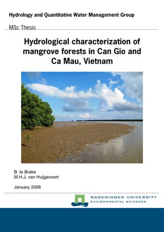
  • 3. Hydrological characterization of mangrove forests in Can Gio and Ca Mau, Vietnam MSc Thesis Hydrology and Quantitative Water Management HWM-80436 Bram te Brake reg. no.: 840121 116 120 Marjolein van Huijgevoort reg. no.: 840924 379 100 Wageningen University Department of Environmental Sciences Hydrology and Quantitative Water Management Group Supervisors: R. Dijksma Hydrology and Quantitative Water Management Group, Wageningen University M.E.F. van Mensvoort Land Dynamics Group, Wageningen University Wageningen, January 2008 Photo on cover: mudflat in front of mangrove forest in Ca Mau, at low tide.
  • 4.
  • 5. Abstract Mangrove rehabilitation projects often fail to achieve their goals, because hydrological characteristics of sites are not taken into account. This is partly because only one tool is available to asses the relationship between hydrology and vegetation in mangrove forests. This tool is a hydrological classification developed by Watson in 1928. In this hydrological classification Watson grouped several mangrove species in five inundation classes based on tidal regime, elevation and flooding frequency. After an exploratory research in Can Gio, Vietnam, Van Loon et al. (2007) proposed an extended hydrological classification. The objective of the current study was verifying this extended classification and testing it for a wider range of hydrological characteristics. Therefore during a measuring campaign from March until May 2007 tidal regimes, elevation profiles, water levels, vegetation, creek flow and groundwater flow were investigated in two study areas in southern Vietnam; Can Gio and Ca Mau. Both study areas have an irregular semi-diurnal tidal regime, but the diurnal component is stronger in Ca Mau. The tidal amplitudes are much larger in Can Gio than in Ca Mau. The elevation profiles showed ridges of a range of magnitudes in several directions and extensive basins, indicating that micro-topography is abundantly present in the mangrove forest. This micro- topography impedes overland flow, so at ebb tide water has to be discharged through slower flow paths like creeks or groundwater. This leads to longer durations of inundations at the sites than expected from their elevation. The calculated hydraulic conductivities indicate that groundwater flow can occur in the mangrove, especially when biopores are present. Net discharge in mangrove creeks could not be calculated, because measurements were not done over complete tidal cycles. Flow velocities showed a tidal asymmetry; ebb velocities were larger than flood velocities. Inundation characteristics of the measurement sites are determined from the measured water levels. These inundation characteristics are used to assign inundation classes to the sites according to the Watson and extended classification. The parameter flooding frequency in the Watson classification leads to unrealistic results in areas with an irregular tidal regime. The extended classification gives better results for areas with an irregular tidal regime and irregular elevation profiles, but still some sites are not classified correctly. During this research mixed zones with both Avicennia alba and Rhizophora apiculata were observed. None of the inundation classes predicts a vegetation pattern with both these species. Therefore a new hydrological classification is proposed with an extra class, 2*. The differences in vegetation and hydrologic conditions in the mixed zone are emphasized by this extra class and sites can be classified more accurately, especially in zones with a lot of variation in vegetation. Since it yields unrealistic results, the parameter flooding frequency is omitted completely. The new classification does not make a distinction between regular or irregular elevation profiles, which makes it easier to use in forest management. For the measurement sites in both Can Gio and Ca Mau the new classification resulted in better predictions of the inundation classes for the measurements sites, although the areas have different tidal regimes and elevation profiles. So, the new classification gives promising results for mangrove rehabilitation projects, because it is suitable for different elevation profiles and tidal regimes and describes vegetation patterns in detail. Keywords: Hydrology; Mangroves; Ecosystems; Hydrological classification; Mangrove restoration; Mangrove rehabilitation; Vietnam.
  • 6.
  • 7. Preface This report is the result of about 9 months work for our MSc-thesis Hydrology and Water Quality, specialization Hydrology and Quantitative Water Management. A thesis about mangrove forest management could be expected in a study like Forest and Nature Conservation, but it was certainly not the first thing we thought of when we started to look for a subject. A field campaign of 3 months in an ecosystem we only knew from pictures and the practical relevance for mangrove management, were two factors that made us decide to go for it. Our very limited knowledge of mangrove forests could be regarded as a disadvantage, but we think it turned into an advantage since it made our work much more interesting and challenging. Of course it was sometimes confusing as well, but we think we managed quite well to stay focused and keep the work relevant. The water dependency of mangroves and the complexity of hydrological processes that occur, definitely offer very interesting opportunities for hydrologists to study. We encountered this during our work in Can Gio and Ca Mau mangrove areas and the subsequent data analysis back in Wageningen. The enormous amounts of articles, books and reviews about mangroves (and mangrove hydrology) that are published emphasize this. It is difficult to tell which part of the work was hardest for us. “Walking” through tick layers of mud, being far away from home and doing hardly anything else than work, sometimes were unpleasant parts of the field campaigns. But, working for months behind a computer in the rainy Netherlands and bringing all the information together might have been even harder. However, the possibility of working in wonderful areas, the people we have met and all the knowledge we have gained, do definitely counterbalance the side-effects. The fact that one of our main sources of information was a book published in 1928, underlines the economical, ecological and social values mangroves have and had. It also indicates the need for research with up to date techniques, since information from 1928 might not be suitable for current projects. Because of the importance of mangrove forest, we found it very inspiring to work on a tool which can be used in mangrove management and rehabilitation projects. There are a couple of people we want to thank for their contribution in our research. First of all, our supervisors, Roel Dijksma and Tini van Mensvoort. To work with you both was a pleasure for us and the conversations and discussions we had were very motivating. Tini, we might have been the last students you supervised, and that certainly is a pity for all the other students after us. We also like to thank our supervisor in Vietnam, Dr. V.N. Nam of Nong Lam University, Ho Chi Minh City. He was of great help in introducing us to mangroves in general and the study areas in particular, arranging research permissions and discussing some results with us. Furthermore, we thank Anne van Loon for providing a lot of information and data, and her willingness to answer all our questions. Other people who helped us during the fieldwork are the staff from the Can Gio Forestry Service, Can Gio Forestry Park and Mui Ca Mau National Park. Special thanks to A. Kiet for his help on the recognition of mangrove species in Can Gio and to Mr. No, who was very helpful in transporting us and our materials in Ca Mau everyday. The same did Mr. Son in Can Gio, for even a longer time, for which we are very grateful. Finally, but certainly not in order of importance, Bram wants to thank Marjolein for the pleasant cooperation and company in the previous year. Marjolein wants to thank Bram for the nice cooperation and all the good times we had during this research. Of course not everything went very smoothly all of the time, but serious problems were absent, while serious fun was abundantly present! We hope that reading this report will please you, as a reader. But above all, we hope that our work can contribute in management of mangrove forests and in successfully carrying out mangrove rehabilitation and restoration projects. Bram te Brake & Marjolein van Huijgevoort Wageningen, January 2008.
  • 8.
  • 9. Contents 1 INTRODUCTION........................................................................................................................................ 1 1.1 BACKGROUND ........................................................................................................................................ 1 1.2 OBJECTIVE OF THE RESEARCH ................................................................................................................ 2 1.3 RESEARCH QUESTIONS ........................................................................................................................... 2 1.3.1 Characterization of mangrove hydrology ......................................................................................... 2 1.3.2 Hydrological classification ............................................................................................................... 2 1.4 STRUCTURE OF THE REPORT ................................................................................................................... 2 1.5 DEFINITIONS........................................................................................................................................... 3 2 THEORY ...................................................................................................................................................... 5 2.1 INTRODUCTION....................................................................................................................................... 5 2.2 HYDROLOGY .......................................................................................................................................... 5 2.2.1 Tides.................................................................................................................................................. 5 2.2.2 River discharge ................................................................................................................................. 6 2.2.3 Meteorology ...................................................................................................................................... 6 2.2.4 Hydrology of mangrove forests......................................................................................................... 7 2.2.4.1 Surface water............................................................................................................................................ 7 2.2.4.2 Groundwater............................................................................................................................................. 7 2.3 MANGROVE ECOLOGY............................................................................................................................ 7 2.3.1 Mangroves......................................................................................................................................... 7 2.3.2 Zonation and succession ................................................................................................................... 9 2.3.3 The relation between hydrology and ecology.................................................................................... 9 2.4 REHABILITATION AND RESTORATION OF MANGROVE ECOSYSTEMS...................................................... 10 2.5 HYDROLOGICAL CLASSIFICATIONS....................................................................................................... 11 2.5.1 Watson hydrological classification ................................................................................................. 12 2.5.2 Disadvantages of the Watson classification.................................................................................... 12 2.5.3 Extended hydrological classification .............................................................................................. 13 3 SITE DESCRIPTION................................................................................................................................ 15 3.1 CAN GIO............................................................................................................................................... 15 3.1.1 History............................................................................................................................................. 15 3.1.2 Can Gio Man-and-the-Biosphere reserve ....................................................................................... 17 3.1.3 Tidal regime .................................................................................................................................... 17 3.1.4 Hydrology........................................................................................................................................ 17 3.1.5 Topography..................................................................................................................................... 17 3.1.6 Vegetation ....................................................................................................................................... 18 3.2 CA MAU ............................................................................................................................................... 19 3.2.1 History............................................................................................................................................. 19 3.2.2 Mui Ca Mau National Park............................................................................................................. 19 3.2.3 Tidal regime .................................................................................................................................... 20 3.2.4 Hydrology........................................................................................................................................ 20 3.2.5 Topography..................................................................................................................................... 20 3.2.6 Vegetation ....................................................................................................................................... 21 4 METHODOLOGY..................................................................................................................................... 23 4.1 SITE SELECTION.................................................................................................................................... 23 4.1.1 Selection criteria of the measurement plots .................................................................................... 23 4.1.2 Locations of the measurement plots................................................................................................ 23 4.2 TIDAL PREDICTIONS ............................................................................................................................. 25 4.3 METEOROLOGICAL DATA ..................................................................................................................... 25 4.4 WATER LEVEL ...................................................................................................................................... 26 4.4.1 Divers.............................................................................................................................................. 26 4.4.2 Analysis........................................................................................................................................... 27 4.4.3 Piezometer locations ....................................................................................................................... 29 4.5 ELEVATION .......................................................................................................................................... 32 4.5.1 Laser levelling................................................................................................................................. 32 4.5.2 Combination of laser levelling and water level data....................................................................... 34
  • 10. Contents 4.5.3 Locations......................................................................................................................................... 34 4.6 VEGETATION ........................................................................................................................................ 34 4.7 CREEK FLOW ........................................................................................................................................ 34 4.7.1 Locations and tidal regime.............................................................................................................. 34 4.7.2 Cross-section................................................................................................................................... 35 4.7.3 Measurements ................................................................................................................................. 36 4.7.4 Calculations .................................................................................................................................... 36 4.8 HYDRAULIC CONDUCTIVITY................................................................................................................. 36 4.8.1 Description of the tests.................................................................................................................... 37 4.8.2 Equations ........................................................................................................................................ 37 4.8.3 Aquifer thickness............................................................................................................................. 39 5 RESULTS.................................................................................................................................................... 41 5.1 TIDAL REGIME...................................................................................................................................... 41 5.1.1 Can Gio........................................................................................................................................... 41 5.1.1.1 Tidal predictions Vung Tau.................................................................................................................... 41 5.1.1.2 Open water measurements...................................................................................................................... 41 5.1.2 Ca Mau............................................................................................................................................ 43 5.1.2.1 Tidal predictions Ha Tien and Dinh An.................................................................................................. 43 5.1.2.2 Open water measurements at C0 and D0................................................................................................ 45 5.2 METEOROLOGY .................................................................................................................................... 47 5.2.1 Air temperature and pressure ......................................................................................................... 47 5.2.2 Precipitation.................................................................................................................................... 47 5.3 ELEVATION .......................................................................................................................................... 48 5.3.1 Elevation measurement sites ........................................................................................................... 48 5.3.2 Elevation profiles Can Gio.............................................................................................................. 48 5.3.3 Elevation profiles Ca Mau .............................................................................................................. 52 5.4 WATER LEVEL MEASUREMENTS ........................................................................................................... 55 5.4.1 Can Gio........................................................................................................................................... 55 5.4.1.1 Plot A ..................................................................................................................................................... 55 5.4.1.2 Plot B...................................................................................................................................................... 56 5.4.1.3 Inundation characteristics....................................................................................................................... 57 5.4.2 Ca Mau............................................................................................................................................ 59 5.4.2.1 Plot C...................................................................................................................................................... 59 5.4.2.2 Plot D ..................................................................................................................................................... 60 5.4.2.3 Inundation characteristics....................................................................................................................... 61 5.5 VEGETATION ........................................................................................................................................ 62 5.5.1 Can Gio........................................................................................................................................... 62 5.5.1.1 Plot A ..................................................................................................................................................... 62 5.5.1.2 Plot B...................................................................................................................................................... 64 5.5.2 Ca Mau............................................................................................................................................ 65 5.5.2.1 Plot C...................................................................................................................................................... 65 5.5.2.2 Plot D ..................................................................................................................................................... 65 5.6 CREEK FLOW ........................................................................................................................................ 66 5.6.1 Can Gio........................................................................................................................................... 66 5.6.1.1 Creek profiles ......................................................................................................................................... 67 5.6.1.2 Flow velocity and water level................................................................................................................. 68 5.6.1.3 Discharge................................................................................................................................................ 69 5.6.2 Ca Mau............................................................................................................................................ 69 5.6.2.1 Creek profiles ......................................................................................................................................... 70 5.6.2.2 Flow velocity and water level................................................................................................................. 70 5.6.2.3 Discharge................................................................................................................................................ 73 5.7 HYDRAULIC CONDUCTIVITY................................................................................................................. 73 6 DISCUSSION ............................................................................................................................................. 75 6.1 TIDAL REGIME...................................................................................................................................... 75 6.1.1 Amplitude ........................................................................................................................................ 75 6.1.2 Diurnal vs. semi-diurnal ................................................................................................................. 75 6.2 ELEVATION .......................................................................................................................................... 75 6.3 WATER LEVEL MEASUREMENTS ........................................................................................................... 76 6.3.1 Time lag between measurement sites .............................................................................................. 76 6.3.2 Inundation characteristics............................................................................................................... 77
  • 11. Contents 6.4 CREEK FLOW ........................................................................................................................................ 78 6.5 HYDRAULIC CONDUCTIVITY................................................................................................................. 81 7 HYDROLOGICAL CLASSIFICATIONS............................................................................................... 85 7.1 RESULTS EXISTING HYDROLOGICAL CLASSIFICATIONS......................................................................... 85 7.2 ERRORS AND UNCERTAINTIES IN EXISTING CLASSIFICATIONS............................................................... 88 7.3 NEW HYDROLOGICAL CLASSIFICATION................................................................................................. 90 7.4 APPLICATION OF THE NEW HYDROLOGICAL CLASSIFICATION ............................................................... 91 8 CONCLUSIONS......................................................................................................................................... 95 8.1 CONCLUSIONS CHARACTERIZATION OF MANGROVE HYDROLOGY ........................................................ 95 8.2 CONCLUSIONS HYDROLOGICAL CLASSIFICATION.................................................................................. 95 9 RECOMMENDATIONS........................................................................................................................... 97 10 REFERENCES....................................................................................................................................... 99 APPENDICES APPENDIX A ABSTRACTS EARLIER RESEARCH APPENDIX B COORDINATES OF THE PIEZOMETER LOCATIONS APPENDIX C TIDAL PREDICTIONS APPENDIX D GRAPHS OF THE WATER LEVELS APPENDIX E VEGETATION APPENDIX F LOCATIONS DISCHARGE MEASUREMENTS APPENDIX G GRAPHS OF THE PERMEABILITY TESTS APPENDIX H VERIFICATION OF THE NEW CLASSIFICATION
  • 12.
  • 13. List of figures 2.1 THE LUNAR PHASE EFFECT, RESULTING IN SPRING AND NEAP TIDE PERIODS ...................................................... 5 2.2 COMMON PROJECTION OF THE EARTH’S ORBITAL PLANE AROUND THE SUN AND THE MOON’S ORBITAL PLANE AROUND THE EARTH........................................................................................................................................ 6 2.3 EXAMPLE OF A PROFILE DIAGRAM OF A TIDAL FLAT IN NORTHERN AUSTRALIA................................................. 9 2.4 NURSERY OF MANGROVE SEEDLINGS IN THAILAND. ........................................................................................ 11 2.5 TIDAL PREDICTION FOR THE PORT OF VUNG TAU FOR THE PERIOD 28 APRIL TO 3 MAY 2004 WITH THREE IMAGINARY SURFACE LEVELS. ...................................................................................................................... 13 3.1 LOCATION OF CAN GIO AND CA MAU; ZOOMING IN FROM THE WORLD TO SOUTHEAST ASIA AND TO SOUTHERN VIETNAM. ..................................................................................................................................................... 16 3.2 MAP OF THE CAN GIO BIOSPHERE RESERVE..................................................................................................... 18 3.3 MAP OF THE SOUTHERN PART OF CA MAU PROVINCE. ..................................................................................... 20 4.1 LOCATIONS OF THE MEASURING PLOTS IN CAN GIO......................................................................................... 24 4.2 LOCATIONS OF THE MEASURING PLOTS IN CA MAU. ........................................................................................ 25 4.3 LOCATIONS OF THE TIDAL STATIONS, METEOROLOGICAL STATIONS AND STUDY AREAS. ................................. 26 4.4 A STANDARD DIVER. ........................................................................................................................................ 26 4.5 PIEZOMETER IN THE FOREST AT FLOOD TIDE. ................................................................................................... 27 4.6 DIVER IN A STILLING WELL .............................................................................................................................. 28 4.7 WATER LEVEL MEASUREMENT BY A DIVER...................................................................................................... 29 4.8 LOCATIONS OF THE PIEZOMETERS IN PLOT A. .................................................................................................. 30 4.9 LOCATIONS OF THE PIEZOMETER IN PLOT B. .................................................................................................... 31 4.10 LOCATIONS OF THE PIEZOMETERS IN PLOT C................................................................................................. 31 4.11 LOCATIONS OF THE PIEZOMETERS IN PLOT D.................................................................................................. 32 4.12 CONCEPT OF THE LASER LEVELLING METHOD ................................................................................................ 33 4.13 PHOTOGRAPH OF THE LASER LEVELLING EQUIPMENT ON A TRIPOD................................................................ 33 4.14 CALCULATION OF THE CROSS SECTIONAL AREA A. ........................................................................................ 35 4.15 PHOTOGRAPH OF THE SET UP USED TO MEASURE HYDRAULIC CONDUCTIVITY. .............................................. 37 5.1 PREDICTED WATER LEVELS AT THE PORT OF VUNG TAU; A) 3 TO 24 MARCH 2007, B) 24 MARCH TO 14 APRIL 2007, C) 14 APRIL TO 5 MAY 2007, D) 5 MAY TO 27 MAY 2007 ................................................................... 42 5.2 COMPARISON OF PREDICTED WATER LEVELS FOR VUNG TAU AND MEASURED WATER LEVELS IN DONG TRANH RIVER FOR THE PERIOD 11 APRIL TO 18 APRIL 2007..................................................................................... 43 5.3 PREDICTED WATER LEVELS AT A) HA TIEN AND B) DINH AN, FROM 21 APRIL TO 20 MAY 2007 ..................... 44 5.4 OPEN WATER MEASUREMENTS AT SITE C0 AND D0 FROM 21 APRIL TO 20 MAY 2007. .................................... 46 5.5 DETAIL OF PREDICTED WATER LEVELS AT HA TIEN AND DINH AN AND MEASURED WATER LEVELS AT SITE D0 FOR THE PERIOD 23 APRIL TO 28 APRIL 2007................................................................................................ 46 5.6 MEASURED PRECIPITATION AT CAN GIO AND NAM CAN WEATHER STATIONS FROM 1 MARCH TO 22 MAY 2007 (AFTER: SOUTHERN REGIONAL HYDROMETEOROLOGICAL CENTER, 2007) AND OBSERVED RAINFALL EVENTS AT MUI CA MAU........................................................................................................................................... 47 5.7 LOCATIONS OF THE LASER LEVELLING TRANSECTS IN PLOT A.......................................................................... 49 5.8 LOCATIONS OF THE LASER LEVELLING TRANSECTS IN PLOT B.......................................................................... 49 5.9 ELEVATION PROFILES IN PLOT A; A) PROFILES PERPENDICULAR TO THE MAIN CHANNEL (TOP), B) PROFILES PARALLEL TO THE MAIN CHANNEL (BOTTOM).. ............................................................................................. 50 5.10 ELEVATION PROFILES IN PLOT B. ................................................................................................................... 51 5.11 LOCATIONS OF THE LASER LEVELLING TRANSECTS IN PLOT C........................................................................ 53 5.12 LOCATION OF THE LASER LEVELLING TRANSECT IN PLOT D. .......................................................................... 53 5.13 ELEVATION PROFILES IN PLOT C; A) PROFILES PERPENDICULAR TO THE MAIN CHANNEL (TOP), B) PROFILE PARALLEL TO THE MAIN CHANNEL (BOTTOM).. ............................................................................................. 54 5.14 ELEVATION PROFILE IN PLOT D PERPENDICULAR TO MAIN CHANNEL............................................................. 55 5.15 DETAIL OF WATER LEVELS IN PLOT A FROM 21 MARCH 13:00 TO 22 MARCH 13:00, 2007............................. 56 5.16 DETAIL OF WATER LEVELS IN PLOT B AND AT A0 FROM 16 APRIL 21:00 TO 17 APRIL 6:00, 2007.................. 57 5.17 DETAIL OF WATER LEVELS AT SITE C1 AND THE ARTIFICIAL SURFACE LEVEL LINE ON 2 CM +SURFACE......... 58 5.18 DETAIL OF WATER LEVEL AND THE APPARENT SOIL SURFACE AT SITE A3...................................................... 59 5.19 DETAIL OF WATER LEVELS IN PLOT C FROM 17 MAY 9:00 TO 18 MAY 9:00, 2007. ........................................ 60 5.20 DETAIL OF WATER LEVELS IN PLOT D FROM 22 APRIL 12:00 TO 23 APRIL 6:00, 2007.................................... 61 5.21 OVERVIEW OF OBSERVED VEGETATION ZONES IN PLOT A.............................................................................. 62 5.22 MIXED ZONE WITH SHRUB LAYER AT THE NORTH BORDER OF TRANSECT 6. ................................................... 63 5.23 A. ALBA AND R. APICULATA DOMINATED MIXED ZONE WITH C. TAGAL......................................................... 64 5.24 SOLITARY A. ALBA IN THE DENSE R. APICULATA PLANTATION IN PLOT B...................................................... 64 5.25 CUT R. APICULATA STRIP IN PLOT C. YOUNG TREES CAN BE SEEN AT THE OPEN SPOTS.................................. 65
  • 14. List of figures 5.26 VEGETATION IN PLOT D WITH A. ALBA, R. APICULATA AND B. PARVIFLORA................................................. 66 5.27 CREEK PROFILES IN CAN GIO: PLOT A (LEFT) AND PLOT B (RIGHT)................................................................ 67 5.28 EXAMPLES OF THE VARIETY OF DISCHARGE MEASUREMENT LOCATIONS; CREEK II, LOCATION 1 (LEFT) AND CREEK VI, LOCATION 6 (RIGHT). ................................................................................................................... 68 5.29 VELOCITY AND WATER LEVELS AT LOCATION 1 AND WATER LEVELS AT SITE A0; 18 MARCH 2007 (LEFT), 28 MARCH 2007 (RIGHT)............................................................................................................................... 69 5.30 CREEK PROFILES IN CA MAU: PLOT C (LEFT) AND PLOT D (RIGHT)................................................................ 70 5.31 WATER LEVELS AT SITE C0 ON 30 APRIL AND 1 MAY 2007 (LEFT) AND AT SITE D0 ON 3 MAY 2007 (RIGHT).71 5.32 FLOW VELOCITY AND WATER LEVELS AT LOCATION 1 ON 30 APRIL 2007 AND LOCATION 2 ON 1 MAY 2007. 72 5.33 FLOW VELOCITY AND WATER LEVELS AT LOCATION 3 AND 4 ON 3 MAY 2007............................................... 72 5.34 DISCHARGE AT LOCATION 1 (30 APRIL), LOCATION 2 (1 MAY), LOCATION 3 (3 MAY) AND LOCATION 4 (3 MAY). ........................................................................................................................................................... 73 6.1 EXAMPLE OF A PARABOLIC VERTICAL VELOCITY PROFILE IN OPEN CHANNELS................................................. 79 6.2 SHIFT IN NEAR BED AND NEAR-SURFACE VELOCITIES AT THE TRANSITION FROM EBB TO FLOOD TIDE.............. 80 6.3 EXAMPLE OF A PARABOLIC HORIZONTAL VELOCITY PROFILE IN OPEN CHANNELS............................................ 80 6.4 EXPECTED HYDRAULIC CONDUCTIVITY PROFILE IN MANGROVE SOILS INTERSECTED BY BIOPORES.................. 82 7.1 RELATION BETWEEN INUNDATION CLASS AND GROWING CONDITIONS FOR 4 SPECIES...................................... 89
  • 15. List of tables 2.1 WATSON’S HYDROLOGICAL CLASSIFICATION................................................................................................... 12 2.2 EXTENDED HYDROLOGICAL CLASSIFICATION................................................................................................... 14 4.1 PIEZOMETER LOCATIONS, DISTANCES TO MAIN CHANNEL AND MEASURING PERIOD......................................... 30 5.1 MEASURED TEMPERATURE DATA IN CAN GIO AND CA MAU. .......................................................................... 47 5.2 ELEVATION OF ALL MEASUREMENT SITES. ....................................................................................................... 48 5.3 AVERAGE TIME LAG AND DISTANCE TO DONG TRANH RIVER FOR PIEZOMETER SITES IN PLOT A. .................... 55 5.4 INUNDATION CHARACTERISTICS FOR PLOT A AND B. ....................................................................................... 58 5.5 AVERAGE TIME LAG AND DISTANCE TO RANG ONG LINH RIVER FOR PIEZOMETER SITES IN PLOT C................. 59 5.6 AVERAGE TIME LAG AND DISTANCES TO CUA LON RIVER FOR PIEZOMETER SITES IN PLOT D........................... 60 5.7 INUNDATION CHARACTERISTICS FOR PLOT C EN D........................................................................................... 61 5.8 OVERVIEW OF DISCHARGE MEASUREMENTS IN CAN GIO. ................................................................................ 67 5.9 MAXIMUM FLOW VELOCITIES IN CREEKS IN CAN GIO. ..................................................................................... 69 5.10 OVERVIEW OF DISCHARGE MEASUREMENTS IN CA MAU................................................................................ 70 5.11 CALCULATED K-VALUES FOR ALL PLOTS........................................................................................................ 74 7.1 INUNDATION CLASSES ATTRIBUTED TO THE MEASUREMENT SITES USING THE WATSON CLASSIFICATION........ 86 7.2 INUNDATION CLASSES ATTRIBUTED TO THE MEASUREMENT SITES USING THE EXTENDED CLASSIFICATION OF VAN LOON ET AL. (2007)............................................................................................................................... 87 7.3 DIFFERENCES BETWEEN EXPECTED AND CALCULATED INUNDATION CLASSES ................................................. 88 7.4 NEW HYDROLOGICAL CLASSIFICATION AND THE SOUTHEAST ASIAN MANGROVE SPECIES ATTRIBUTED TO EACH CLASS. ................................................................................................................................................. 92 7.5 INUNDATION CLASSES ATTRIBUTED TO THE MEASUREMENT SITES USING THE NEW CLASSIFICATION OF TABLE 7.4. .................................................................................................................................................... 93
  • 16.
  • 17. 1 1 Introduction 1.1 Background Mangrove forests occur in sub-tropical and tropical regions around the world (Alongi, 2002). There are about seventy known mangrove species, which are all tolerant to salt and brackish waters (Field, 1998). The total area occupied by mangroves globally is difficult to determine, but is estimated to be between 181 000 and 198 800 km2 in 1997 by Spalding et al. (in Field, 1998). Mangrove ecosystems are highly productive, but also very vulnerable (Tabuchi, 2003). According to Alongi (2002) “approximately one third of the mangrove forests over the world have been lost in the past 50 years”. However Kairo et al. (2001) report that “less than 50% of the original total cover of mangroves” has remained. The losses of mangroves can be contributed to the fact that they are heavily exploited, since mangroves are highly productive ecosystems. The main threats for mangroves are overexploitation of the natural resources, deforestation, conversion to aquaculture and salt-ponds, mining, pollution and industrial or urban development (Field, 1998, Alongi, 2002). Natural disasters like tropical cyclones (Tri et al., 1998) and the tsunami of 26 December 2004 in Asia, can also devastate mangrove ecosystems (Barbier, 2006, Van Loon et al., 2006). Mangroves are valuable ecosystems that provide a natural barrier against storms, stabilize coastlines and have a high economical value for humans, who depend on their natural resources (Hong and San, 1993). Therefore rehabilitation and restoration projects are carried out all over the world to prevent further degradation and losses of mangrove areas. Rehabilitation is defined by Field (1998) as “partially or fully replacing structural or functional characteristics of an ecosystem”. Field emphasizes that ecological rehabilitation may also hold substitution of the disturbed or degraded state to a situation of alternative characteristics than those originally present, as long as these alternative characteristics have more social, economic or ecological value. Restoration on the other hand is described by Field as “bringing an ecosystem back into its original condition”. Rehabilitation projects in general have three main objectives: conservation of a natural system and landscaping, sustainable production of natural resources and protection of coastal areas (Barbier, 2006, Field, 1998). Unfortunately in mangroves many of these rehabilitation projects fail to achieve their goals or result in mono-specific plantations, which can not be seen as successful ecological restoration (Lewis, 2001). The failure of these projects is often caused by lack of adequate site selection (Ellison, 2000) and no determination of characteristics of the sites (Lewis, 2005). Especially the hydrological characteristics of sites are often not taken into account. For example, in Vietnam Rhizophora apiculata has been planted on mudflats in front of the forest, where this species can not survive partly due to the wet conditions. According to Lewis (2001) “the single most important factor in designing a successful mangrove restoration project is determining the normal hydrology (depth, duration and frequency of tidal flooding) of existing natural mangrove plant communities”. The influence of hydrology on the mangrove ecosystem is also recognized by Hughes et al. (1998), who mention it as a “key determinant” for several processes, and by Field (1998), who states that “hydrology of the site is of great importance”. However, little research is undertaken to quantify the relation between hydrology and vegetation. In 1928, Watson developed a hydrological classification in which he grouped the main mangrove species in five inundation classes based on tidal regime, elevation and flooding frequency. In this way he described the distribution of mangrove species near Port Swettenham at the Malay peninsula (Watson, 1928). This classification is often used in rehabilitation projects (Hong and San, 1993, Lewis, 2005, Van Loon, 2005), because no other general hydrological tool is available. Nam (2007) however stated that the classification is not used anymore, since it does not describe hydrological site characteristics well. After an exploratory hydrological research in Can Gio, Van Loon et al. (2007) also concluded that the Watson classification gave unsatisfactory results in this area (Appendix A). The classification was found to be unsuitable for regions with an irregular elevation profile and/or an irregular semi-diurnal tidal regime. Therefore Van Loon et al. developed an extended hydrological classification for regions with regular as well as irregular elevation profiles and tidal regimes. The main parameter added in the extended classification is duration of inundation. This classification gave better results for the Can Gio area (Van Loon et al., 2007). With this extended classification mangrove rehabilitation projects might be more successful in the future.
  • 18. 1 Introduction 2 1.2 Objective of the research The development of this extended classification gave rise to further research of the interaction between hydrology and vegetation occurrence in mangrove areas, to increase the number of successful rehabilitation and restoration projects. Therefore the main objective of this study is to verify the extended Watson classification, as is proposed by Van Loon et al. (2007), and to test the applicability of this classification for a wider range of hydrological characteristics. Since the extended classification is based on relatively short data series and limited measuring locations, only some sites in Can Gio, this study focuses on extending the existing data series in Can Gio and on testing the classification in a mangrove area with different hydrological characteristics. In this research field campaigns have been carried out in Can Gio and Ca Mau, both located in southern Vietnam. This study is divided in two main sections. First, the general hydrological characteristics of the study areas are investigated. Furthermore the hydrological classification is tested using these characteristics, to determine its suitability for different areas. 1.3 Research questions 1.3.1 Characterization of mangrove hydrology For the first part, investigating general hydrological characteristics in the study areas, the central question is: What are the hydrological characteristics of the research areas, with respect to the tidal regime and flow patterns and how do these characteristics change in time? To answer this question the following sub-questions are formulated and answered for each area: - What is the tidal regime in the area and what are the differences within each of the areas? - What is the flow pattern in the area and how does this change over time? - How can the groundwater flow of the mangrove forest be characterized? 1.3.2 Hydrological classification The central question of the part of the research focusing on the applicability of the extended classification is: Is there a consistent relation between hydrological characteristics and mangrove development and can this lead to an extended Watson classification? Sub-questions formulated with this question are: - What are the differences with respect to the factors frequency and duration of tidal inundation within a transect and between transects on different locations? - What are the interactions of the elevation, tidal regime and the groundwater flow with the dynamics of the mangrove vegetation along a transect? 1.4 Structure of the report The different chapters in this report are mentioned and shortly described below. Chapter 2 Theory; gives a description of mangrove ecosystems in general, the vegetation within mangroves and the role of hydrology, based on literature. The hydrological classifications of both Watson (1928) and Van Loon et al. (2007) are described in this chapter. Chapter 3 Site description; contains information about the two different study areas. The history, hydrology and vegetation in both areas are treated based on literature research. Chapter 4 Methodology; presents all the methods of the measurements carried out in the mangrove forest during this research.
  • 19. 1.5 Definitions 3 Chapter 5 Results; describes the results of the measurements carried out during this research which are aimed at determining the hydrological characteristics of the study areas. Chapter 6 Discussion; explains parts of the results in more detail. It discusses connections between different observations within this research and between these observations and results of other research available from literature. Chapter 7 Hydrological classifications; discusses the results of the hydrological classifications of Watson and Van Loon et al. obtained from the measured hydrological characteristics. A new hydrological classification is proposed. Chapter 8 Conclusions; gives the conclusions of both the characterization of mangrove hydrology and the hydrological classifications. Chapter 9 Recommendations; indicates possibilities for further research. The appendices contain additional data obtained from the measurements during this research, a list of optimum requirements of several mangrove species with regard to soil-type and frequency of inundation, a list of measurement locations and additional information. 1.5 Definitions The word ‘mangrove’ has several definitions in literature. It is both used to refer to “the constituent plants of tropical intertidal forest communities or to the community itself” (Tomlinson, 1986). In this report the word ‘mangrove’ refers to the community, so ‘mangrove forest’ and ‘mangrove’ are used in the same way. The definition of mangrove forest as given by the Joint Group of Experts of the Scientific Aspects of Marine Environmental Protection of IMO/UNESCO/WMO/WHO/IAEA/UN/ UNEP is used in this report. This group defines a mangrove forest as (European environment agency glossary, 2007): “A community of salt-tolerant trees and shrubs, with many other associated organisms, that grows on some tropical and sub-tropical coasts in a zone roughly coinciding with the intertidal zone.” The individual species within the mangrove forest are referred to by their scientific name. Abbreviations are used for the most common species in this report. The genus Rhizopora is abbreviated to R., Avicennia to A., Bruguiera to B. and Ceriops to C., the species names are not abbreviated. So for example the species Bruguiera parviflora becomes B. parviflora and Rhizophora apiculata is written as R. apiculata. The annex spp. is used to indicate several species of the same genus together, like Rhizophora spp.. When the different vegetation zones are described the abbreviations Rh and Av refer to the Rhizophora zone and Avicennia zone. For the analysis of the data from the measurements several equations are needed. Together with the definition of the parameters in these equations the dimensions in which the parameters should be expressed are given, instead of units. These dimensions are notated between square brackets. So the dimension length of a parameter is displayed with [L], which can be centimetres, metres or kilometres. The same applies to [T], which is the notation for the dimension time.
  • 21. 5 2 Theory 2.1 Introduction This report discusses a research on the relation between hydrology and ecology of mangrove forest. Therefore, some background information might be needed on the hydrology of mangrove forests, the ecology of mangrove forests or the connection between these two. In this chapter an overview of relevant topics in these subjects is given. Van Loon (2005) incorporated a literature study on mangrove hydrology and ecology in her study on water flow and tidal influence in Can Gio. The paragraphs 2.2, 2.2.2, 2.2.3, 2.2.4, 2.3.3 are mainly based on this literature study. The complete literature study of Van Loon can be found in Van Loon (2005). 2.2 Hydrology According to Hughes et al. (1998) the hydrology is a key determinant in species distribution, wetland productivity and nutrient cycling and availability in mangrove systems. Therefore studying the hydrology in a mangrove-delta system has a high priority. Hydrological research in mangrove systems is done by, among others, Wolanski (1980 to 1992), Mazda (1990 to 2006), Hughes (1998) and Kitheka (1997). In tropical coastal waters the main forcing factors for the coastal hydrology are the tide, river discharge and meteorology (Kitheka, 1997), which interact in different ways. 2.2.1 Tides Tide is the phenomenon of periodic sea level rise and fall. Tidal water movements, both horizontal (flow velocity) and vertical (water level), are caused by a complex interaction of astronomical forces and hydrodynamic effects of the ocean bottom topography and the coastal configuration. The astronomical forces relevant in the generation of tides are mainly the attractive power of the moon and the sun. During the 29.53 day’s cycle of the moon around the earth, the gravitational attraction of moon and sun may variously act along a common line or at different angles (Figure 2.1). Figure 2.1 The lunar phase effect, resulting in spring and neap tide periods (Center for Operational Oceanographic Products and Services, 2005). This lunar phase shift results in an alternation of higher (spring tide) and lower (neap tide) than average tidal range over approximately 2 weeks. Next to this, both the moon and the earth revolve in elliptical orbits and consequently the distances between the sun and the earth and the moon and the earth vary (Figure 2.2). Increased tide-raising forces are produced when the moon is at position of perigee, its closest position to the earth (once each month), or the earth is at perihelion, its closest
  • 22. 2 Theory 6 position to the sun (once each year, around 2 January). Figure 2.2 shows the situation of perigee coinciding with perihelion. In this situation tides of increased range are generated. On the other hand considerably reduced tidal ranges occur when apogee, aphelion, and the first- or third-quarter moon coincide at approximately the same time. In general, tidal forces are mainly induced by the moon, since solar tide generating effects are smaller than the lunar effect. (Center for Operational Oceanographic Products and Services, 2005) Figure 2.2 Common projection of the earth’s orbital plane around the sun and the moon’s orbital plane around the earth (Center for Operational Oceanographic Products and Services, 2005). The varying interaction of astronomical forces and hydrodynamic effects results in different tidal regimes between different regions. Tidal regimes are characterized by the amplitude and the frequency of the tides. In coastal seas the bathymetry has a large influence on the tidal regime. A coastal sea is usually relatively shallow leading to an increase in tidal wave height (Rijn, 1990, in Van Loon, 2005). Tidal regimes are often classified as diurnal, semi-diurnal and mixed, based on the frequency of high and low water levels. There are however no sharply defined limits separating the groups. In general, the tide is said to be diurnal when both high tide and low tide occur only one time each day during the greater part of the month. The tide is semi-diurnal when two high and two low tides occur each day with approximately the same amplitude. In mixed tidal regimes the diurnal and semi-diurnal components are both important factors and the tide is characterized by large variations in high and/or low water levels. There will usually be two high and two low waters each day, but occasionally the tide will become diurnal. Therefore these tidal regimes are called irregular semi-diurnal. (Voigt, 1998) 2.2.2 River discharge In delta areas the tidal wave from the coastal sea enters the creek system. In this region the tides experience the influence of the discharge of river water through the creeks, generally in the direction of the sea, although different flow routes may be determined by the magnitude of the discharge, the tidal regime, the configuration of the creeks, and possible hydrological obstructions. 2.2.3 Meteorology River discharge depends on precipitation and losses of water, mainly evapotranspiration, in the river basin. Major rainfall events, which occur in tropical regions during only one season, are highly significant for flow patterns, but have only a short-term effect on water levels (Hughes et al., 1998). Furthermore, wind has an influence on the water movement in a delta region. Wind influences the tidal regime through possible dampening and amplifying effects, and the direction of the wind can affect the water distribution in the creek system.
  • 23. 2.3 Mangrove ecology 7 2.2.4 Hydrology of mangrove forests 2.2.4.1 Surface water According to Mazda et al. (1997) “reports on mangrove hydrodynamics are largely restricted to the tidal creeks, and measurements in the swamp itself are sparse”. Water that reaches a tidal flat occupied by mangrove forest by overland flow, behaves differently than creek water due to the presence of vegetation and the limited water depth. Due to bottom friction large vertical shear exists, which might result in low flow velocities or even stagnant water. Mazda et al. (1997) carried out hydrodynamic measurements in a mangrove swamp and presented observations of the drag force due to vegetation on tidal currents through mangrove swamps. Tidal regime and elevation are not the only factors determining the frequency, duration and height of inundation of a tidal flat. Topography and vegetation at the tidal flat have a significant influence on the duration (Van Loon et al., 2007) and frequency of inundation. In the wet season higher precipitation and river discharge can cause the water at high tide to flood a larger area than in the dry season (Thom et al., 1975). With strong tidal currents, as during spring tide, the tidal influence is the dominant water transporting process in the mangrove swamp and groundwater flow does not contribute much to hydrodynamics (Wolanski, 1992). However, during neap tide the groundwater movements can become an important factor in the mangrove hydrology. 2.2.4.2 Groundwater As the topography of a delta region is flat and a large area of land is frequently flooded, groundwater levels are usually very high. Groundwater behaviour is controlled by a combination of effects of tidal processes, precipitation and evapotranspiration and possibly regional groundwater flow (Hughes et al., 1998). Depending on the location in the delta, the distance to open water and the period of the year, the tidal regime or the meteorological variables are the most important. According to Hughes et al. (1998) the tidal forcing is the dominant mechanism for pore water movement in the saturated and intertidal zone of a delta. Close to the creek water table movement is directly coupled to fluctuations in water level of the creek and thus of the tidal movements. With increasing distance from the creek the fluctuations in groundwater level rapidly decline. At a distance of 5 to 10 m from the creek the water table movement is negligible. Consequently, at the inland parts of the mangrove swamp evapotranspiration is the only way groundwater levels can be lowered. In the wet season fluctuations in groundwater level are considerable due to the irregular character of the rainfall if the area is not flooded for a long period. During the dry season the water table will drop gradually due to the increasing evapotranspiration in case of no replenishment. The latter situation results in a high groundwater salinity. At some inland locations mangrove trees are not able to survive and a salt marsh with specific salt-tolerant vegetation will develop (Hughes et al., 1998). 2.3 Mangrove ecology 2.3.1 Mangroves Mangroves are forests consisting of a group of salt-tolerant trees and shrubs that can develop along sub-tropical and tropical coasts. They develop best along sheltered coastlines and in delta regions where waves are broken. In sheltered estuaries and lagoons mangroves are usually extensive and may stretch up to several kilometres inland, with a gradual transition to terrestrial vegetation (Tomlinson, 1986). Mangroves grow along rivers and creeks as long as there is tidal movement and the water is salt or brackish (Poorter and Bongers, 1993, in Van Loon, 2005). The distribution of mangroves is divided in two groups by several authors (Chapman, 1976, Duke et al., 1998, Tomlinson, 1986), which are the Eastern and Western mangroves. Here the names of the groups indicate the hemisphere on which the species are found, but other names are also mentioned in literature. The total number of true mangrove
  • 24. 2 Theory 8 species1 in the Eastern group, including East Africa, India, southeast Asia, Australia and the Western Pacific, is 40. In the Western group only eight true mangroves species are found. (Tomlinson, 1986) Composition of the groups not only differs in number, but also in species; no species is present in both groups. Mangroves in Vietnam are part of the Eastern group. The southeast Asian sub-region is recognised as the biogeographical province supporting the most diverse mangroves in the world. The highest diversity of mangrove plant species has been recorded in this sub-region (Tri et al. 2000). Mangrove forests are frequently inundated by tides, which is a primary existence factor for many of its species. Mangrove trees however perform best under fresh water conditions, but they loose competition with other species in fresh water environments. Due to specific physiological adaptations in their tissue, mangrove trees can survive in saline and brackish water environments and under anaerobic conditions which occur during moments of inundation. These adaptations make mangrove families an unique group of trees and plants that are able to survive along coastlines, which form an inaccessible habitat for other species. Adaptations to tidal inundations and saline water are not the only characteristic features of mangrove species. Mangroves have to cope with variable water levels, unstable soils, salinity of the water leading to physiological dryness, lack of oxygen, water flow etc. (Van Loon, 2005). Tomlinson (1986) reports a list of major features that are typical for all or most of the mangroves species: 1. Complete restriction to the mangrove environment; they occur only in mangrove forest and do not extend into terrestrial communities. 2. A major role in the structure of the community and the ability to form pure stands. 3. Morphological specialization that adapts mangroves to their environment; the most obvious being aerial roots and vivipary of the seed. 4. Some physiological mechanism for salt excretion which enables mangroves to grow in saline water. 5. Mangrove species are separated from their relatives at least at the generic level and often at the subfamily or family level. Especially criterion 1 and the vivipary of seed are very distinctive. Many mangrove species have special roots, called pneumatophores. These roots enable the trees to get some air, during shallow inundations and in water saturated soils. Aerial roots are often regarded as the main feature of mangrove species, but many other forest swamp plants develop aerial roots as well (Tomlinson, 1986). Mangrove seeds develop on the parent tree and grow out into propagules, which are viviparous. When released from the parent tree they might be transported by water movements or settle near the parent tree. Most mangrove species have propagules that float on water. The establishment of propagules depends on the number of days propagules remain buoyant and viable, the strength of surface currents, the water conditions, and the availability of suitable sites (Duke et al., 1998). Suitability of sites is determined by the depth of inundation, the presence of other mangrove trees and the salinity of the water (Van Loon, 2005). Vanspeybroeck (1992) found that mangrove seedlings in Kenya are restricted to sites where their parent trees are found, even when parental trees have been felled. This can be due to a poor dispersal of propagules or the presence of suitable environmental conditions (Ashton and Macintosh, 2002). Clarke and Kerrigan (2000) and Matthijs et al. (1999) also report hypotheses and observations of propagule and seedling distributions following parental zonation. Other studies show that mangrove seedlings establish on a different site than their parent trees due to changes in site conditions. For example, A. germinans propagules can establish in zones where they are not usually found (Patterson et al., 1997) and in general it applies that mature mangrove trees can survive on sites with environmental conditions that are sub-optimal for seedling establishment (Watson, 1928). 1 True mangrove species consist of plants which are absolutely confined to salt or brackish water, while mangrove associates are plants which belong to more inland vegetation but can frequently be found with true mangrove species (Hong and San, 1993).
  • 25. 2.3 Mangrove ecology 9 2.3.2 Zonation and succession The existence of vegetation zones, often monospecific, along environmental gradients is called zonation. Zonation is often very evident in mangrove forests (Tomlinson, 1986). Profile diagrams, as often used to describe zonation, may give the impression that zonation is a regular series of vegetation bands parallel to the coastline. However, according to Tomlinson (1986) “any regular zonation is modified by local topography, which determines tidal and fresh-water runoff, and by sediment composition and stability”. An example of a schematic and generalized profile is shown in Figure 2.3. Figure 2.3 Example of a profile diagram of a tidal flat in northern Australia. HWS indicates high water level at spring tide. (Adapted from: Tomlinson, 1986) A common assumption is that the zones of species along a transect represent their succession in time (Chapman, 1976, Thom et al., 1975, Tomlinson, 1986). Pioneer species establish on newly exposed mudflat and as environmental conditions change, more climax species can enter the region and displace the pioneer species. The gradient in conditions perpendicular from the coast is thought to be the main factor controlling zonation (Thom et al., 1975). Ellison et al. (2000) state that ordering of groups of species, at a given location with respect to elevation is predictable, with the upper limit of one group marking the lower limit of a second. Numerous authors have given environmental factors determining zonation. According to Chapman (1976) tidal factors, salinity, drainage, currents and soil composition are the most important factors. Rabinowitz (1978) states that factors related to the once mentioned by Chapman, like length of the submersion period, daily and seasonal fluctuations in salinity, soil consistency or texture, availability of fresh water, competitive ability and water-logging, “are thought to occur in gradients from the front to the back of the swamp or along channels”. Mangrove species respond physiologically to these factors such that each species has a preferred area within the forest. Tomlinson (1986) also mentions physiological responses to gradients as one of the factor influencing zonation, but he also discusses other, both biotic and abiotic, factors. These are geomorphology, inundation classes, propagules sorting and, competition. Inundation classes to describe zonation are extensively discussed by Watson (1928) (chapter 2.5.1) and propagules sorting by Rabinowitz (1978). According to Lewis (2005) zonation is based upon the nature of the tide that inundates an area rather than the number of times or total period of inundation; few have ever quantified it. 2.3.3 The relation between hydrology and ecology All the above mentioned ecological factors are assumed to influence mangrove distribution in an area. Apparently, not one set of environmental factors is causing mangrove zonation (Matthijs et al., 1999). However, the main determining factor for the ecology in a mangrove system is water.
  • 26. 2 Theory 10 Species distribution along a gradient is strongly dependent on hydrological factors. Hogarth (1999, in Van Loon, 2005) pointed out the importance of the hydrological variables, frequency and duration of inundation. In their study Stumpf and Haines (1998) mention the importance of the elevation relative to Mean Sea Level (MSL) or Mean High Water (MHW). From an ecological perspective the highest tide each day (MHHW) should be the most relevant in determining species distribution, but MSL is a good estimate. According to Vanspeybroeck (1992) however, the elevation above Mean Low Water (MLW) is the predominant factor affecting the distribution of mangrove trees. Of course all these factors are strongly interrelated. The tidal inundation frequency is found to be the most common variable to illustrate species zonation patterns (Ellison et al., 2000). Additionally the intensity of water flow dynamics and waves influence the establishment of mangrove propagules and the development of the seedlings (Matthijs et al., 1999, Vanspeybroeck, 1992). For example Rhizophora seedlings will generally not survive or even settle if exposed to direct sea action, while A. alba is a species often found at the coastline under the influence of tidal currents and wave action. The influence of the water on mangrove ecology is not only direct. Inundation influences a number of other environmental variables. Soil factors may be altered by flooding (Matthijs et al., 1999) and it may prevent salt accumulation in mangrove soils (Susilo and Ridd, 2005). 2.4 Rehabilitation and restoration of mangrove ecosystems As mentioned before (chapter 1.1), mangrove ecosystems are very vulnerable and large areas are lost in recent periods. However, the importance of the mangroves for coastal protection and the unique values of these ecosystems are becoming more widely recognized and therefore rehabilitation and restoration projects are carried out globally. The main objectives of these projects are: conservation of a natural system and landscaping, sustainable production of natural resources and protection of coastal areas (Barbier, 2006, Field, 1998). However, according to Ellison (2000) “the majority of projects, especially those in southeast Asia, continue to emphasize afforestation”. So, instead of focusing on restoring ecosystems, they are aimed at establishing plantations that can be exploited for fuelwood, charcoal and wood chips for rayon production (Ellison, 2000). These plantations can not be seen as successful rehabilitation of mangroves, since they do not restore biodiversity and the characteristics of the mangrove ecosystem. To achieve successful mangrove restoration Lewis and Marshall (1997, in Lewis, 2005) have identified five critical steps: 1. Understand the autecology (individual species ecology) of the mangrove species at the site, in particular the patterns of reproduction, propagule distribution and successful seedling establishment. 2. Understand the normal hydrologic patterns that control the distribution and successful establishment and growth of targeted mangrove species. 3. Assess the modifications of the previous mangrove environment that occurred that currently prevents natural secondary succession. 4. Design a restoration program to initially restore the appropriate hydrology and utilise natural volunteer mangrove propagule recruitment for plant establishment. 5. Only utilise actual planting of propagules, collected seedlings or cultivated seedlings after determining that natural recruitment will not provide the quantity of successfully established seedlings, rate of stabilisation, or rate of growth of saplings established as goals for the restoration project. However, many rehabilitation and restoration projects do not take these steps into account and especially ignore hydrological characteristics of sites. Most important in the rehabilitation is adequate site selection and investigating the sites characteristics. The reason for the initial degradation of site has to be understood before rehabilitation (Field, 1998). Before planting of seedlings or propagules, the hydrology of the site has to be known and, if needed, restored. Turner and Lewis (1997) give several examples of projects in which hydrologic restoration of rehabilitation was successful in reversing negative effects of earlier changes.
  • 27. 2.3 Mangrove ecology 11 This is also indicated by Brockmeyer et al. (1997), who observed a rapid recovery to more natural conditions of a wetland after restoring tidal exchange. Restoration of the normal tidal flooding regime is especially important for rehabilitation of disused shrimp ponds, because tidal regime is usually blocked by dikes in these areas (Lewis et al., 2003). An example of inadequate site selection is given by Lewis (1999, in Lewis et al., 2003); large plantations of Rhizophora spp. on existing unvegetated natural mudflats resulted in failures and a waste of funds, since natural tidal conditions of the mudflat are too wet for these species to establish. Besides, it is arguable whether changing existing mudflats into plantations is desirable. Due to monospecific afforestation the ecological and social values of the intertidal mudflats are lost and it results in habitat conversion rather than restoration (Erftemeijer and Lewis, 1999). It might also be a loss of economical value, since mudflats may be used for cockle fishery, as in Can Gio. After adequate site selection and hydrologic restoration, planting might be needed. There are two different approaches for mangrove planting; natural regeneration and artificial regeneration. Natural regeneration makes use of naturally occurring propagules or seeds of mangroves as the source for regeneration, resulting in a mix of locally present species. When there is insufficient natural regeneration, artificial regeneration is needed. Seeds, propagules or seedlings can be planted directly on the site or first be raised under nursery conditions and then planted (Figure 2.4). (Field, 1998) The first choice for rehabilitation should be natural regeneration, according to Field (1998) and Lewis and Marshall (1997, in Lewis, 2005). Overall, the most important lesson learnt from failed rehabilitation and restoration projects is the importance of accurately determining site characteristics, especially hydrology, before starting with planting of mangrove trees. Figure 2.4 Nursery of mangrove seedlings in Thailand (picture by Roel Dijksma). 2.5 Hydrological classifications The relation between tidal flooding and vegetation in mangrove forests is still relatively unknown. In 1928, Watson gave a first classification indicating five inundation classes and related mangrove species. De Haan (1931, in Chapman, 1976) proposed six different inundation classes based on the number of floodings per year, while he also examined salinity tolerances and requirements of species.
  • 28. 2 Theory 12 The allocation of the vegetation in the inundation classes between these two classifications differed (Chapman, 1976). After these mangrove schemes based on tidal flooding, Davis (1940, in Knight et al., 2007) and Macnae (1966, in Knight et al., 2007) indicated zonation schemes within the mangrove forest. As a supplement to these zonation schemes Lugo and Snedaker (1974) divided the forest in five major community types. They indicated that “the formation and physiognomy of these types appear to be strongly controlled by local patterns of tides and terrestrial surface drainage and they are distinguishable on these bases”. The five major community types are: fringe forest, riverine forest, overwash forest, basin forest and dwarf forest (Lugo and Snedaker, 1974). This hydrogeomorphic classification takes the importance of surface hydrology and tidal dynamics into account. However, these hydrologic characteristics are not quantified as in Watson’s classification. The extended classification of Van Loon et al. (2007) is based on the classification of Watson (1928). Both these classifications will be discussed in more detail in the following chapters. 2.5.1 Watson hydrological classification In 1928 Watson made a classification based on the nature of the tide. He distinguished five different inundation classes. The limits of the classes are highly arbitrary and only valid for the area of Port Swettenham, Malaysia, where Watson carried out his research (Watson, 1928). The tidal regime in this area is extremely regular and elevation in the forest is gradually rising from the coast. Despite these limitations, discussed by Watson, the classification is still used in current research and forest management projects, since it is regarded as the best hydrological tool available. The classification developed by Watson is given in Table 2.1. After dividing the tidal regime in five inundation classes, Watson indicated which vegetation can develop in each class. The distribution of the different species over the inundation classes is based on the ability of the species to regenerate itself under the given conditions (Watson, 1928). So species can exist in adjacent inundation classes, but will not find optimum requirements to regenerate in that case. Table 2.1 Watson’s hydrological classification (Watson, 1928). Inundation class Tidal regime flooded by Elevation above admiralty datum Flooding frequency times per month Vegetation species 1 2 3 4 5 all high tides medium high tides normal high tides spring high tides equinoctial tides below 244 cm 244 to 335 cm 335 to 396 cm 396 to 457 cm 457 cm and above 56 to 62 45 to 59 20 to 45 2 to 20 - to 2 none Avicennia spp., Sonneratia Rhizophora spp., Ceriops, Bruguiera Lumnitzera, Bruguiera, Acrostichum aureum Ceriops spp., Phoenix paludosa 2.5.2 Disadvantages of the Watson classification During the research of Van Loon et al. (2007) several disadvantages of the classification of Watson were found. The hydrological classification of Watson is developed for an area with a regularly rising elevation profile and an extremely regular tidal regime. In most mangrove forests ridges and basin structures are found, thereby creating an irregular elevation profile. These ridges impede overland flow, so water has to be discharged through sub-creeks or the soil, which are longer flow paths than overland flow. This affects the wetness of the soil and the duration of inundation. Within the classification of Watson this is not taken into account (Van Loon et al., 2007). An important factor in the classification is the frequency of inundation. An irregular semi-diurnal tidal regime has varying tidal amplitudes. This causes large variations in the high and low water levels and leads to inundation frequencies that also vary over time. The inundation frequency and duration of inundation of a site is determined by its elevation and the tidal regime. This is illustrated for an irregular semi-diurnal tidal regime in Figure 2.5. A site with elevation “1” mostly experiences one
  • 29. 2.5 Hydrological classifications 13 long inundation per day, so its inundation frequency is low. Only the highest high water level can reach a site with elevation “3”, so this site also has a low inundation frequency. A site with elevation “2” is reached by all high waters, but also falls dry between the high waters at a semi-diurnal tide. So this site has a higher inundation frequency than site “1” and “3”. (Van Loon, 2007) Therefore the parameter “frequency of inundation” gives unrealistic results for an irregular tidal regime, as a site that stays inundated during a longer period (“1”) gets a higher (drier) inundation class than a site with more but shorter inundations (“2”). As mangrove forests often have an irregular elevation profile and an irregular tidal regime, the classification of Watson might not be applicable in all cases. Figure 2.5 Tidal prediction for the port of Vung Tau for the period 28 April to 3 May 2004 with three imaginary surface levels (1 = -50 cm +MVT, 2 = 25 cm +MVT, 3 = 75 cm +MVT) (Van Loon et al., 2007). 2.5.3 Extended hydrological classification Van Loon et al. (2007) developed an extended hydrological classification based on the classification of Watson to improve the applicability for regions with an irregular elevation profile and irregular tidal regime. This extended hydrological classification is displayed in Table 2.2. The parameter “tidal regime” is not changed in the extended classification, but should only be used for a rough comparison and when no other data of the hydrological conditions are available. The parameter “elevation” is referred to Mean Sea Level instead of admiralty datum, because this is more used in practical situations and it is less arbitrary. The parameter “flooding frequency” is unchanged. For both these parameters the limits of the classes are changed for a more realistic prediction (Van Loon et al., 2007). Since the parameters elevation and flooding frequency were not suitable for irregular elevation profiles and/or an irregular tidal regime, Van Loon et al. have added the parameter “duration of inundation” expressed in minutes per day as well as minutes per inundation. At sites in a regular elevation profile the parameter elevation can be used to classify the sites, otherwise the duration of inundation should be used.
  • 30. 2Theory 14 Table 2.2 Extended hydrological classification (Van Loon et al., 2007). Inundation class Tidal regime Elevation cm +MSL Flooding frequency times per month Duration of inundation min per day Duration of inundation min per inundation Vegetation species 1 2 3 4 5 all high tides medium high tides normal high tides spring high tides equinoctial tides < 0 0 - 90 90 - 150 150 - 210 >210 56 - 62 45 - 56 20 - 45 2 - 20 < 2 > 800 400 - 800 100 - 400 10 - 100 < 10 >400 200 - 400 100 - 200 50 - 100 < 50 none Avicennia spp., Sonneratia Rhizophora spp., Ceriops, Bruguiera Lumnitzera, Bruguiera, Acrostichum aureum Ceriops spp., Phoenix paludosa
  • 31. 15 3 Site description The study areas for this research are situated in Ho Chi Minh City and Ca Mau provinces in southern Vietnam (Figure 3.1). The study area in Ho Chi Minh City province is located in the Saigon-Dong Nai river delta in Can Gio. Can Gio is a suburban, marine district 65 km southeast of Ho Chi Minh City. The Biosphere reserve in Can Gio district, which includes the study area, covers 76 000 ha of land and measures 35 km from north to south and 30 km from east to west. The coordinates are 10°22’-10°40’N and 106°46’-107°00’E. The second study area is located at the Ca Mau peninsula, the southern tip of Vietnam, which is bordered by the Gulf of Thailand on the west and the South China Sea on the east. The south western tip of the peninsula forms Mui Ca Mau National Park (Cape Ca Mau). Mui Ca Mau National Park has a total area of 42 000 ha, and is located at 8°32’-8°49’N, 104°40’-104°55’E in Ngoc Hien and Nam Can district. Both areas consist mainly of planted mangrove forest, but naturally regenerated parts are also present. In these parts the research sites were located. The climatic conditions in southern Vietnam are dominated by the seasonally reversing monsoon circulation, resulting in two prevailing winds; the dry north-easterly and the rainy south-westerly monsoon2 . This results in a moist tropical climate with a dry season from approximately December to April and a rainy season from about May to November (Tong et al., 2004). The mean annual temperature at sea level is about 27°C with little annual variation and precipitation is high. March, April and May have the highest monthly average temperatures, December and January the lowest (Van Loon, 2005). Mean annual precipitation in Can Gio is approximately 1 336 mm, September has the highest rainfall amount of on average 300-400 mm (MAB Vietnam National Committee, 1998). Ca Mau receives on average approximately 2 200 mm per year, in 120-150 rainy days (Hong and San, 1993). 3.1 Can Gio 3.1.1 History Within the Can Gio district mangrove forests account for 53% of the total natural area, about 40 000 ha (Tri et al., 2000). During the Second Indochina war (1962-1971) Can Gio was heavily sprayed with herbicides and defoliants, killing almost all vegetation (Tri et al., 2000). The most used defoliant was Agent Orange. After the war some natural regeneration of mangrove species occurred, but this new vegetation was destroyed by local people that used the wood as fuel. From 1978 the government started investing in reforestation programmes. This reforestation consisted mainly of monoculture of R. apiculata, although the mangrove species Nypa fruticans, Ceriops and R. mucronata were also planted on smaller scale (Hong, 2001). According to Hong (2001) an area of 35 000 ha was replanted with mangrove trees by 1996 and “the mangrove flora is now fairly similar to that before the herbicide spraying, although the amounts and distribution are not the same”. The Can Gio district has about 58 000 inhabitants. The activities of these people form a big threat to the natural environment. They cut down trees for timber and fuel and use parts of the mangrove for shrimp cultivation. The demand for fuel and timber remains larger than the supply from thinning. The management of R. apiculata plantations in Can Gio includes one thinning after 6 to 7 years, a second thinning after 9 to 10 years and a third thinning after 15 years. The final felling is carried out if plantations are 20 years of age (Hong, 1996). To prevent destruction of the mangroves, parts of the forest have been allocated to households, which protect their part for 30 years. In return for protecting the allocated forest, they can use a small part of it for aquaculture or salt production (Tri et al., 2000). Besides the households, forestry experts and rangers also protect the forest. 2 The term monsoon is used in literature both for the circulation of surface winds in tropical regions and for the prevailing wind which lasts for several months, thereby determining the climatic conditions in a season.
  • 32. 3 Site description 16 Figure 3.1 Location of Can Gio and Ca Mau; zooming in from the world to southeast Asia and to southern Vietnam (Center for Sustainability and the Global Environment, 2007).
  • 33. 3.1 Can Gio 17 3.1.2 Can Gio Man-and-the-Biosphere reserve In 2000 the MAB/UNESCO Committee appointed Can Gio as the first International Man-and-the- Biosphere Reserve in Vietnam. Authorities in charge of the reserve are the management board for protected forests from the Department of Agriculture and Rural Development, Ho Chi Minh City and the Peoples Committee of Can Gio district (Tri et al., 2000). The Can Gio reserve is divided in a core area, buffer zone and transition area. The core area consists of the forestry units 4b, 6, 11, 12 and 13 (dark green areas in Figure 3.2), and measures 4 700 ha (Tri et al., 2000). Management in this area is aimed at preserving the ecosystem and species diversity (Van Loon, 2005). There are some villages, with a population of around 300 people, but inhabitants are only allowed to carry out fishery activities and selective timber cutting at a sustainable level (Tri et al., 2000).The buffer zone comprises the other 18 forestry units (lighter green areas in Figure 3.2) and includes about 37 000 ha land as well as 3 800 ha marine environment (Tri et al., 2000). Within this zone a moderate level of habitation and economic development is allowed. Important activities are sustainable exploitation, scientific research and tourism (Van Loon, 2005). Ecotourism is becoming increasingly important in Can Gio since this generates income for local people. The remaining part of the biosphere reserve is transition area, which holds 29 000 ha land and 600 ha marine environment (yellow areas in Figure 3.2). Within this zone some land has been converted to agricultural land and the main crops produced are rice, coconut and pineapple. However productivity is low due to irrigation problems and salt intrusion. Urban areas, abandoned land and roads are also part of the transition area. (Tri et al., 2000) 3.1.3 Tidal regime The Can Gio area has an irregular semi-diurnal tidal regime, so most of the time high and low tide situations occur twice a day, except for some periods when only one high and low tide in 24 hours occur. The amplitude of the tidal regime is high: 3.3 to 4.1 m. In October and November maximum high tide water level is reached, in May the minimum. (MAB Vietnam National Committee, 1998) 3.1.4 Hydrology The mangrove ecosystem in Can Gio is not only influenced by the tides, but also by Dong Nai river. The main channel of this river has a length of 628 km and has several important tributaries, including the Saigon river (Ringler et al., 2002). The Dong Nai river flows from Cambodia through Vietnam to the South China Sea and its annual average discharge varies between 970 m3 /s and 1 600 m3 /s (Van Loon, 2005). The tropical climate causes a large variation between discharge in the dry season and wet season. During the rainy season, the river basin receives on average 87% of the total annual precipitation (Ringler et al., 2002). The maximum monthly discharge is 3 890 million m3 and the minimum 145 million m3 (Van Loon, 2005). Besides this difference, there are also large variations in flow between different years. The Dong Nai river basin includes several hydropower projects and reservoirs. It is the second largest river basin in hydropower potential in Vietnam. Although three major reservoirs are constructed in the basin, the large variation in flow between the seasons still exists. However, the reservoirs can prevent water shortages in the catchment during the dry season (Ringler et al., 2006). The increase in water flow in the dry season has decreased the salinity in the Can Gio area. Salinity in the mangrove forest is highly dependent on the seasons. During the rainy season salinity is only 4 to 8 ppt, while during dry months salinity can increase up to 19 to 20 ppt in the north and 26 to 30 ppt near the sea. The average monthly salinity is 18 ppt (Hong, 1996). 3.1.5 Topography Since Can Gio is part of the Saigon and Dong Nai river delta it has a low-lying, relatively flat and dynamic topography (Van Loon, 2005). The highest elevation found in the area is 10 m above sea level (MAB Vietnam National Committee, 1998), but almost the entire area has an elevation between 0 and 2 m above sea level (Tri et al., 2000). The area consists of a system of unstable alluvial islands with a dense network of rivers, channels, creeks and gullies. The fresh sediment beds are eroded by the swift river currents and wave action (Van Loon, 2005).
  • 34. 3 Site description 18 Four main soil types in Can Gio are: saline mangrove soil, acid sulphate soil with a pH from 4.5 to 6.5, marine sandy soil and sand dune soil. All these soils were developed from young marine and fluviatile deposits in the Quaternary period (Chien et al., 2003), in which the Holocene was probably the main contributing period. Figure 3.2 Map of the Can Gio Biosphere reserve (Centre for tropical marine ecology, 2007). 3.1.6 Vegetation Since most of the mangrove area in Can Gio has been replanted after the war, the area is dominated by R. apiculata. However, natural vegetation has also regenerated, mostly along rivers and creeks. These natural zones have a high biodiversity compared with the planted areas and main species are Avicennia spp., Sonneratia alba, Xylocarpus granatum, Kandelia candel, Ceriops spp., Xylocarpus moluccensis, Rhizophora spp., Lumnitzera littorea, Phoenix paludosa, Excoecaria agallocha and Acrosticum aureum (Van Loon, 2005). Hong (2001) has found 72 flora species, 30 of which are true mangroves and 42 are associate mangrove species, during his research in Can Gio.
  • 35. 3.2 Ca Mau 19 3.2 Ca Mau 3.2.1 History It is estimated that before 1943 mangrove covered about 150 000 ha in the entire Ca Mau province (Maurand 1943, Moquillon 1950, in Tong et al., 2004). Like in Can Gio, the area was sprayed with herbicides and defoliants during the second Indochina war. According to Hong and San (1993) the tip of Ca Mau peninsula was sprayed heavily between 1966 and 1970, leading to an irreversible destruction of 52% of dense mangroves (45 000 ha) in the current study area. Of these mangroves 80% was natural Rhizophora forest. After the war, in 1975, natural regeneration and planting programs led to partial recovery of the mangrove vegetation. Natural regeneration at the tip of Ca Mau peninsula was very slow however, due to large quantities of dead trunks and wood damaging young seedlings or even hampering propagules from reaching favourable sites. This phenomenon was still one of the reasons for failure of natural regeneration 10 years after spraying (Hong and San, 1993). Extensive replanting was done mainly with monocultures of R. apiculata (Clough et al., 2002). Despite reforestation efforts, population pressure and conversion of mangrove forest to agriculture land, shrimp farms and fish ponds hampered the rehabilitation of mangroves. Relatively to other areas in Vietnam, the Ca Mau peninsula still had extensive areas of mangrove forest, which attracted people from other provinces to make a profit of these natural resources. In the early 1980’s the Vietnamese government encouraged shrimp farming for export, because over-fishing in coastal waters had led to a rapid decline of shrimp capture. Especially in the western provinces of southern Vietnam shrimp farming became a wide-spread activity (Hong and San, 1993). Shrimp farming appeared to be highly profitable leading to both expansion of existing farms and establishment of new farms, partly by migrants from other provinces. In the period 1983-1992 the population in Ngoc Hien district, where the main part of Mui Ca Mau National Park is situated, nearly doubled due to unauthorized influx of people from other provinces (Hong and San, 1993). Both overexploitation of mangrove resources due to population growth and expansions of shrimp farming contributed largely to the loss of mangrove forests in Ca Mau. Shrimp farming caused major changes in drainage patterns and tidal flooding frequency of the area (Tong et al., 2004). In the short period November 1987-July 1988, the area of mangroves in Ngoc Hien district decreased by 13 992 ha. In an attempt to increase mangrove area, mixed farming systems, where levees within the ponds are vegetated by mangroves, arose the last decade (Populus et al., 2003). 3.2.2 Mui Ca Mau National Park In 2003 Mui Ca Mau National Park was established by merging Dat Mui Nature Reserve, Bai Boi Coastal Protection Forest and some adjacent natural mangroves. Dat Mui and Bai Boi reserves consisted respectively of the southern and northern part of the current area of Mui Ca Mau National Park (Figure 3.3). Dat Mui Nature Reserve was already established in 1983, while Bai Boi Coastal Protection Forest was only set up just before the establishment of the national park. Mui Ca Mau National Park is, like the Can Gio Biosphere Reserve, divided in 3 management zones: core zone, buffer zone and transition zone (National Political Publishing House Vietnam, 2006). The core zone consists mainly of regions with strict protection, both forest land and coastal surface water. Hardly any human activity is allowed in this zone, except for forest management and scientific research. No people live in this zone and any form of aquaculture is prohibited, although fishing in natural open waters is allowed (Nam, 2007). The core zone’s function is to protect natural processes and ecology of mangrove forests, provide living environment for water birds and aquatic species, protect coastal areas and minimize natural calamities (National Political Publishing House Vietnam, 2006). The buffer zone forms an area with both possibilities for settlement and forest development. In this zone no aqua- or agriculture is allowed, but local people can live within it and use natural resources in a sustainable way. The transition zone forms the landward edge of the national park and is the main area of settlement and aquacultural activities. It borders the land not belonging to the national park.
  • 36. 3 Site description 20 Figure 3.3 Map of the southern part of Ca Mau province. Dat Mui and Bai Bo, parts of Mui Ca Mau National Park, are indicated (Asian Development Bank, 2007). 3.2.3 Tidal regime Although Mui Ca Mau National Park is situated at the south western tip of the Ca Mau peninsula, its tidal regime is determined by both the Gulf of Thailand and the South China Sea due to Cua Lon river. This river bisects the southern part of the peninsula from east to west, thereby connecting both seas. In the South China Sea the tidal regime is irregular semi-diurnal with an amplitude of 2.5-3.8 m. In the Gulf of Thailand a diurnal tidal regime predominates with relatively small amplitudes; 0.5-1.0 m (Nguyen et al., 2000). The combination of both tidal regimes and the extensive intertwined creek system in Ca Mau peninsula causes complex water interactions that are not fully understood (Tong et al., 2004). It results in an irregular semi-diurnal regime with amplitudes of 0.8-1.5 m at Cape Ca Mau where Cua Lon river discharges in the Gulf of Thailand. 3.2.4 Hydrology The Ca Mau peninsula is situated in the Mekong delta, but its hydrological conditions are not directly influenced by the Mekong River (Hong and San, 1993). The water in channels and rivers is saline; no fresh water is present in the area. Mean salinity is 22-26 ppt, which is a favourable range for many mangrove species. Salinity is rather constant throughout the year, since rainfall in the rainy season mixes with abundant seawater or it takes up accumulated salt from tree canopy (Hong and San, 1993, Populus et al., 2003). 3.2.5 Topography The geomorphology of Ca Mau peninsula is highly determined by the Mekong river. In rainy periods large volumes of sediment are transported by the Mekong river to the South China Sea. Coastal currents carry the sediments south-westwards, resulting in formation of sandy beach ridges at the south eastern coastal plain and deposits of finer sediment at the southwest coast of Ca Mau peninsula.
  • 37. 3.2 Ca Mau 21 Resulting landforms are beach-ridge and spit systems3 around the present channels as well as a deltaic margin in the southwest (Nguyen et al., 2005). At Mui Ca Mau the mudflats are extending rapidly westwards; extension rates up to 80 m/y are reported by Hong and San (1993). The east side of the peninsula however is subjected to considerable erosion. Topography at Ca Mau peninsula is relatively even and low-lying, with most of the land lying within the intertidal zone between about +1 m and -1 m with regard to MSL (Clough et al., 2002). Soil texture is for 95% of the soils clayey or loamy (Tong et al., 2004), but reports about acidity are conflicting. Tong et al.(2004) state that acid sulphate soils are uncommon, while Hoanh et al. (2006) report deep acid soils in the southern part of Ca Mau peninsula. According to Van Mensvoort (2007) potential acid sulphate soils were present, but drainage after construction of channels and shrimp ponds revealed a minor pyrite layer only. Shells, lime and saline water that were present created a sufficient buffer capacity to prevent large scale and severe acidity. 3.2.6 Vegetation The mangrove forests of Mui Ca Mau National Park are dominated by Avicennia spp. and Rhizophora spp., but Ca Mau peninsula has an abundant supply of propagules and seedlings of many mangrove species. Due to an extensive network of canals, good conditions for dispersion of seeds and propagules and the tropical monsoon climate, the area is highly suitable for mangrove development. Mangroves in the Ca Mau peninsula are the best in Vietnam in terms of number of species and tree sizes. At the eastern coast large stands of A. marina and A. officinalis are found, although erosion is diminishing the area covered by these forests. On newly accreted land with a substrate of deep, soft mud and affected by low-tide, a pure and pioneer population of A. alba is found growing along the coast and river banks. Also mixed communities of R. apiculata-B. parviflora and A. alba-R. apiculata occur. (Hong and San, 1993) 3 Spit: A long narrow accumulation of sediment lying generally in line with the coast, with one end attached to the land and the other projecting into the sea or across the mouth of an estuary (Voigt, 1998).