1. Data Compilation, Multi-Source Integration, and Three-Dimensional (3D) Modeling of Camp Bird Mine, Colorado
Elizabeth Anastasia Hedrick, David Gonzales, Mike Thompson, Maureen Moore-Roth
Fort Lewis College Department of Geosciences, Durango, Colorado
ABSTRACT
The western San Juan Mountains are well known for a historical mining
legacy that spans about 125 years. Most of the mining and related geologic
activities for the mines are preserved in hard copy documents and paper files. Few
digital compilation exist.
The goals of this research were twofold. Historical and recent geologic
and mine data for the Camp Bird mine near Ouray, Colorado were used to generate
a three-dimensional representation of the mining working at different levels. This
thesis focused on the understanding and application of established methodologies
to digitize historic plans and model the mine workings of the iconic Camp Bird
Mine, utilizing software developed for integrating, editing, and modeling large
amounts of complex spatial data. The historical data existed in paper maps and
geologic profiles, but there was a desire to generate digital compilations to make
quick and accurate assessments of the value and risks associated with exploration
and feasibility of mine-development; understanding the geology of ore deposits,
geothermal and hydrological studies, and the environmental impacts of
engineering project(s). The process applied in this project required digitizing and
synching of data from maps into digital documents with the aide of GIS and
Vulcan software. This presentation highlights the steps and challenges in creating
this digital product.
The second initiative of this project is to illustrate the power of the
digital word for the preservation of historical documents and maps that are
vulnerable to loss, deterioration from age, poor archiving conditions, the onerous
challenges of sharing historical data for mining activities and within the public
domain. Virtual reconstruction through the process of creating a digital database
and 3D models of mine workings from historic documents is of tremendous
academic and economic value.
REFERENCES CITED
Will be made available upon request
ACKNOWLEDGMENTS
Thank you Fort Lewis College and the Department of Geosciences specifically:
Dr. David Gonzales, Dr. Ray Kenny, Andrea Kirkpatrick, and the Undergraduate
Research and Creative Activities Grant Committee; Mike Thompson; Maptek for
providing training and technical support to educational institutes, specifically:
Maureen Moore, Carolina Christiensen, Michaela Crum, Mark Bourget, Nate
Bazer, and Chuck Winters. Additionally, I would like to acknowledge the aid of
Kirstin Brown, Chuck Baltzer, and Dr. Ray Kenny in facilitating my initial
understanding of how to decipher and assemble data of this nature within the
constructs of a smaller project; and my father, Sam Hedrick, for proofing the
countless products related to this project.
STUDY OBJECTIVES
• Development of new skills using Geographic Information Sciences and
Vulcan
• Conversion of historic 2D data into digital formats useful for mine
operations
• Investigation of the process of creating a digital database of mine workings
using modern tools and software to digitize historical documents and their
incorporation into comprehensive three-dimensional (3D) models (3DGM).
• This data was compiled with the hope of gaining support in reopening the
mine, closed since the 1989, and develop new exploration and mining
plans, bringing it’s legacy into the 21st century.
SETTING
Within the heart of the Western San Juan Mountains, hundreds of underground
mining operations have been established and abandoned since initial
discoveries of gold and silver in the 1700's. Of those established, only a few
have been able to withstand the ebbs and flows of the economy to become legacies
such as the Camp Bird Mine.
• Established in 1896 by Thomas Walsh as a collection of mine claims (Fischer
et al, 1968; Smith, 2004; Smith, 2006).
• The Camp Bird mine has been developed over the span of seven generations
since the first claims were staked in 1877, and includes 21 levels and sub-
levels, extending to over 25 miles of mine workings.
• The most profitable mine in Colorado for many years.
• Maintained high gold production for decades .
• Represented the best of current mining methods and equipment.
• Attracted visitors from around the world.
SOURCES OF DATA
Caldera Mineral Resources compiled and indexed over 2,000 historic maps
and plans, varying in details from the follow sources in 2012:
• Ouray County Historical Society
• San Juan County Historical Society
• Numerous private entities with historic ties to the mine
This data was generously supplied to author by Mike Thompson
SOFTWARE AND DEVELOPED METHODOLOGY
• This project was completed utilizing VULCAN (Maptek Pty Ltd.) an industry
leading software in 3D Geologic Modeling (3DGM) since 1986 (Foley,
2013).
• Developed with a clear focus on mine optimization through improved
knowledge and understanding of mineralization zones of the geological
background, Vulcan provides the ability to assimilate data in order to
develop and visualize a multitude of strategies, with which audiences from
differing backgrounds can utilize to understand using 3D interactive
graphics (Maptek, 2015; Royer et al., 2013; Neilson and Kapageridis, 2000).
Existing methodologies require several steps to process data, depending on their
type.
1. Collecting, sorting, and identification of usable data.
2. Processing and Geo-referencing in order to build a consistent dataset
(Kaufmann and Martin, 2008).
3. Once the appropriate design files are created, the multi-source 2D data can be
digitized and integrated.
CONCLUSIONS
• Models can be analyzed comparatively with the data from which they were
derived. Furthermore, they can be used to increase spatial understanding of
subsurface features within the public domain.
• Preservation of history and comprehensive understanding of the
complexities existing within underground mines.
• Although Vulcan’s primary applications are in understanding and modeling
geology of ore deposits, oil and gas reserves, geothermal and hydrological
studies, this software is an effective tool in understanding the
environmental impacts of any engineering project (Neilson and Kapageridis,
2000), natural hazards, and other quantifiable geological processes.
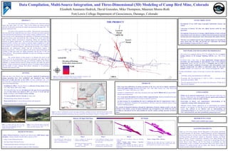
Figure 3: Looking north east down the valley
toward Ouray from Camp Bird mine at the mill
located near the Level 14 Portal, Circa 1939.
(Library of Congress, 2016)
Figure 4: View of the mine dump at the Level 3
Portal, as viewed from the Chicago Portal Area.
(Image credit: Mike Thompson, 2012)
PROBLEM
• Many maps and publications of mining operations in the area exist, but no digital compilations
exist in the public domain (Burbank and Luedke, 1933, 1968, 2008; Fischer et al., 1968; Steven and
Lipman, 1977; Fisher, 1990; Bove et al., 2001).
• Attempts to comprehensively study these documents and maps can be difficult due to inaccessibility
and piecemeal organization.
• There is too much information to be shown within a single document, therefore information has been
purposefully separated with a series of overlays created for each level.
• An ideal strategy for accomplishing the task of combining this data for comprehensive study is
through it’s digitization integration into geodatabases, allowing visual and statistical analyses using
software modeling programs.
The creation of integrated databases through the digitization of historic mining records is not only
essential to the historic record of human habitation and development of the WSM, but also in
providing an educational tool for understanding the specific complex geologic dynamics of historic
mines.Figure 2: Location of Camp Bird Mine, Colorado. Data Sources: Basemap is a Hillshade derived from a 10m DEM obtained from the USGS.
Roads, rivers, towns, and significant peak data is from ESRI. Inset modified from King and Allsman, 1950. Projected Coordinate System:
NAD 1983 NSRS 2007 State Plane Colorado South. Lat/Long coordinates are in Decimal Degrees. Created by: E.A. Hedrick, 2016.
Historic 2D High Wall Plans
Step 1:
• Geo-reference the image using at
least 2 coordinates (x,y) from the
grid system within the plans.
Step 4:
• Create solids out of polygon using the following
commands:
Model > Triangle Solid > Polygon > Specified
Projection > Specify Height.
• Repeat the process, changing the height to make the
polygons you want to “Cut out” taller than the object you
want to keep.
Step 5:
Model > Triangle Utility > Boolean.
• Utilizing this tool allows the user to exclude the “cut”
polygons from the solid model. Once created, these solids
can be utilized to run analysis, such as volumes.
Step 3:
• Create additional polygons around
areas that need to be omitted from
the solid object.
• Assign the primitive object z values
correlating with specified elevation.
Step 2:
• Create a polygon by tracing the
boundary the targeted object.
• More than one polygon may need to
be created, depending on
completion of the data
3D Models
µ
Level 3
Portal
Level 14
Portal
7,687ft NE
THE PRODUCT
Figure 1: 3D model of Camp Bird Mine from the compilation, integration, and
digitization of historic mine plans in Vulcan (Hedrick, 2016)
LEGEND
12,500
9,150
Elevation of Workings
In feet above mean sea level
1,000 ft.