
Recommended
Recommended
More Related Content
Similar to Meteorito en Carancas, Puno, Perú
Similar to Meteorito en Carancas, Puno, Perú (20)
More from juank28
Recently uploaded
Recently uploaded (20)
Meteorito en Carancas, Puno, Perú
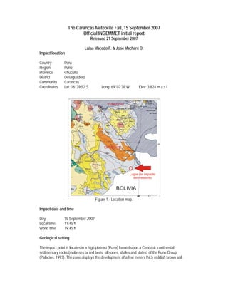
- 1. The Carancas Meteorite Fall, 15 September 2007 Official INGEMMET initial report Released 21 September 2007 Luisa Macedo F. & José Macharé O. Impact location Country Peru Region Puno Province Chucuito District Desaguadero Community Carancas Coordinates Lat: 16°39’52”S Long: 69°02’38”W Elev: 3 824 m a.s.l. Figure 1.- Location map. Impact date and time Day 15 September 2007 Local time: 11:45 h World time 19:45 h Geological setting The impact point is locates in a high plateau (Puna) formed upon a Cenozoic continental sedimentary rocks (molasses or red beds: siltsones, shales and slates) of the Puno Group (Palacios, 1993). The zone displays the development of a few meters thick reddish brown soil.
- 2. General description of the phenomenon (Only anecdotic information based upon witnesses’ declarations) Apparent displacement azimuth of the object: towards N030°E. The object was observed since it was at about 1 000 m from the earth surface. The object presented a strongly luminous head (white light) and a white smoky queue. No other objects were observed to fall after the main body. There was a strong explosion that was felt up to Desaguadero city 20 km from the impact site. Some window glasses of the Local Health Center (at 1 km from the site) were broken. The explosion “sound” lasts about 15 minutes (!) After the impact, boiling water was seen in the crater, and a smoke column was formed that lasts for several minutes. A “sulfurous” smell was reported there. General description of effects on ground The impact created a crater when collided with the soft ground (reddish brown soil). The crater is composed by a hole and an ejecta rim. The central hole became a pond, by infill with groundwater that crops out after the impact (figure 2). The following table gives the diameters and other measures of the geoform. The maximum rim height was 1 m above the original soil level, and was seen in the northern border. The photo of figure 2 is looking northward. Dispersal ejecta made by brown soil with grey patina (meteorite powder), up to 5 cm in diameter were found at 200 m from the impact point. Three days after the fall, water in the pond was 1 m below the original soil level. It presented turbid brown aspect, with pH = 7.8, temperature 17.9°C, conductivity > 4000 milisiems, and total suspended solids > 2000 ppm. (Measurements by Prof. Mario Soto, Univ. of Altiplano, Puno). Figure 2.- Carancas crater lake and ejecta rim. Looking to the north.
- 3. First results of meteorite samples analyzed Sampling by the INGEMMET scientist has been only partial. When she arrived, 36 hours later than the impact occurred, most major fragments had been taken by villagers. Naked-eye observations show fine grained, light grey, fragile rocky material with disseminated iron of 1mm diameter (figures 4, 5, and 6). Thin and polished sections were prepared for petro-mineralogic determinations under optical microscope. They revealed chondritic texture, and a mineral composition including pyroxene, olivine, iron, troilite, and alkali (?) feldspar. Fig. 4 Natural aspect with striated surface Fig. 5 Natural aspect with iron oxide inclusion Figure 6.- Free face after cutting. Surface coating is artificial resin not a reaction crust. Fragments in all photos are 4-5 cm. tall. Thin and polished sections were prepared for petro-mineralogic determinations under optical microscope. The results revealed chondritic texture and a mineral composition including: Pyroxene 1 40% Olivine 20% Feldspar 10% Pyroxene 2 10%
- 4. Opaque minerals total about 20% and include: Kamacite 15% Troilite 5% Cromite traces Native Cu traces Figure 7.- Thin section of the Carancas meteorite. Parallel and crossed nicols. Figure 8.- Polished section of the Carancas meteorite. Ongoing and proposed further studies Initial results will be complemented and refined with ICP-MS chemical analysis and SEM-Edax analysis being done in Peru. Results are expected at the beginning of the next week. Several world scientists have offered to participate with special tests including oxygen isotope analyses to study the origin, ESEM and FESEM studies and determinations of C/N and C/S ratios in any interesting embedded microstructures, and FE ASEM probing to characterize impact microstructures. Water from the pond as well as soil samples from the impact zone are being analyzed for chemical composition in Peru. Final considerations Scientists from the Peruvian Institute of Nuclear Energy have reported that non radioactive material was detected in association with the sampled object. From our field observations and information given by the Puno Regional Health Director, the initial report about 200 people affected by headache, vomits and stomachache seems
- 5. exaggerated. Ill people would be around 30, and additional 20 children from the local school are being examined. Causes of illness are still unknown. Owing to the social issues associated with the impact, new results will continue to reach first the Instituto de Defensa Civil (INDECI) which authorize their public release. It is recommended to protect the site to preserve the field evidence and allow further research. Acknowledgements Instituto Nacional de Defensa Civil Municipalidad de Desaguadero Universidad Nacional del Altiplano Gobierno Regional de Puno Participants Field geology: Luisa Macedo Petro-mineralogy: Teresa Velarde, Cesar Cánepa, Hans-Jürgen Bernhardt, Laura Plascencia. Geochemistry: Vicentina Cruz Coordination: José Macharé Information: Hernando Núñez del Prado, Rosana Ramírez. ------------