Disability disasters and empowerment
•Download as PPT, PDF•
2 likes•926 views

Dhaka Conference on disability and disaster risk management - December 2015

Recommended
More Related Content
What's hot
What's hot (18)
Viewers also liked
Viewers also liked (19)
Similar to Disability disasters and empowerment
Similar to Disability disasters and empowerment (20)
More from Sightsavers
More from Sightsavers (17)
Recently uploaded
Recently uploaded (20)
Disability disasters and empowerment
- 1. Disability, disasters and empowerment Dhaka Conference on disability and disaster risk management - December 2015
- 2. © Sightsavers Presentation outline •Evidence from qualitative research with participants from Satkhira in a Sightsavers and Disabled Rehabilitation and Research Association (DRRA) disability inclusive disaster preparedness programme •Outline the forms of empowerment accessed by people with disabilities participating in self-help groups formed in the programme; within groups and externally reaching outwards to influence change •Research findings demonstrate the importance of engaging people with disabilities and the bodies responsible for decision-making at all level •Engagement has led to changing attitudes and tangible linkages and representation with the bodies responsible for disaster management 12/16/15
- 3. © Sightsavers Sightsavers and DRRA programme DRRA and Sightsavers agreed disaster preparedness and livelihoods are a priority in this region Funded through Sightsavers Innovation Fund (UK Department for International Development) Formed 24 self help groups in 12 Unions; three Upazilas in Satkhira; one in Khulna. Each self help group has 15 members Aimed to: • Address vulnerability of people with disabilities to disasters by forming self- help groups of people with disabilities and parents of children with disabilities (identified by DRRA) • Increase participant's knowledge of disaster preparedness • Access existing support for livelihoods and identify innovative livelihood opportunities • Build capacity of participants to engage with bodies responsible for disaster management • Advocate for disability rights at local and national level 12/16/15
- 4. © Sightsavers Context for people with disabilities Nationally: •Increasingly disability-inclusive legislation (gaps in implementation) •Negative family and community attitudes •Stigma and discrimination •Inaccessibility •Challenges accessing employment, health care and education •Existing gender inequality heightens barriers for women and girls with disabilities – ‘double and multiple forms of discrimination’ Satkhira: •Poorest and most conservative region – extremely challenging, very limited resources •Lack of knowledge of disability issues – local leaders and service providers •Women and girls with disabilities face additional constraints around mobility due to conservative belief systems 12/16/15
- 5. © Sightsavers Natural hazards or disasters? •Impacts of disasters are socially constructed, hazards only become ‘disasters’ for certain people: poorest people in a community are often the most vulnerable to impacts; those with strong livelihoods and resources tend to be more ‘resilient’ •Particular relevance for people with disabilities: poverty and disability are inextricably linked due to the number of barriers people with disabilities face accessing education, health care and employment •Lack of evidence on the relationship between disability and disasters; and practice of inclusive disaster risk reduction / humanitarian intervention 12/16/15
- 6. 12/16/15 To edit, go to View > Header & Footer
- 7. © Sightsavers 12/16/15 To edit, go to View > Header & Footer
- 8. © Sightsavers Types of environmental hazard 12/16/15 To edit, go to View > Header & Footer
- 9. © Sightsavers Types of environmental hazard 12/16/15 To edit, go to View > Header & Footer
- 10. © Sightsavers Main types of environmental hazard Cyclones •Sidr (2007) •Aila (2009) Flooding •Frequent flooding •Complex river systems •Heavy rainfall / monsoon climate Waterlogging •Waterlogged for months at a time (up to 6 months) •Results from tidal surges / floods / storm surges •Blocked dams / creating sluices •Sometimes deliberate – shrimp cultivation •Government Official claimed 2011 waterlogging only occurred as canals had been tampered with 12/16/15 To edit, go to View > Header & Footer
- 11. © Sightsavers Types of environmental hazard Flooding Waterlogging 12/16/15 To edit, go to View > Header & Footer
- 12. © Sightsavers Types of environmental hazard 12/16/15 To edit, go to View > Header & Footer
- 13. © Sightsavers Types of environmental hazard 12/16/15 To edit, go to View > Header & Footer
- 14. © Sightsavers Context in Satkhira Poverty and housing •Despite conditions people are often reluctant to leave shelters as they have nothing left to return to •Majority of houses are made of mud, bamboo and/or tin •Located in highly vulnerable positions •After previous disaster do not have resources to rebuild with anything other than the same vulnerable materials •Exposed to the next environmental hazard 12/16/15 To edit, go to View > Header & Footer
- 15. © Sightsavers Context in Satkhira 12/16/15 To edit, go to View > Header & Footer
- 16. © Sightsavers Context in Satkhira 12/16/15 To edit, go to View > Header & Footer
- 17. © Sightsavers Context in Satkhira Limited range of livelihoods • Land owners cultivate crops, poultry, livestock • Salinity limits crop production • Majority of people work as day labourers • Fishing, shrimp, crab cultivation – vital to the region • Increasingly undermined by hazards: • Assets washed away • Render fertile land unproductive Poverty, challenging livelihoods and disruption due to regular disasters “Everything gets disrupted…everything, every livelihood, because everything is empty…they have to rebuild from scratch” Quote from a Union Chairman 12/16/15 To edit, go to View > Header & Footer
- 18. © Sightsavers Research methodology 12/16/15 To edit, go to View > Header & Footer Research objectives • Identify the causes of vulnerability to disasters for people with disabilities in Satkhira • Assess how participation in self-help groups has influenced participants access to forms of empowerment Data collection • Group discussions / semi-structured interviews • Satkhira / Dhaka • Bangla / English • Recorded and transcribed Sampling / site selection • Purposive sample (participants / relevant stakeholders) • Three out of four Upazilas in project
- 19. © Sightsavers Data collection 12/16/15 To edit, go to View > Header & Footer Research findings
- 20. © Sightsavers Vulnerability to disasters 12/16/15 To edit, go to View > Header & Footer Poverty and barriers accessing livelihoods: wider context of poverty and hazards; discriminatory attitudes of employers; economic pressure Increased risk factors for women: existing gender inequalities; daily responsibilities; reduced social mobility in comparison to men; social taboos on physical contact even during evacuations; abuse at shelters Reduced mobility: widespread inaccessibility; hazards change the environment; lack of specific evacuation plans; discrimination Inaccessible shelters and relief distribution: shortage of space; inaccessible physical environment and sanitation facilities; lack of specific measures to ensure relief is accessed at shelters and in communities Inaccessible warning systems: lack of consideration for people with sensory, multiple or complex disabilities
- 21. © Sightsavers Empowerment within groups 12/16/15 To edit, go to View > Header & Footer Forms of empowerment produced through participation in self help groups Evidence within self help groups: Trust Knowledge Norms / actions • Shared experiences • Common aspirations • Functioning groups • Collaboration • Disability rights • Understanding impairments • Disaster preparedness • Disaster response • Reaching out • Organisational activities • Changing attitudes • Inclusive changes in the community
- 22. © Sightsavers Empowerment within groups 12/16/15 To edit, go to View > Header & Footer Shared experiences of exclusion / growing confidence from participation “They think I am not effective, I am not useful for them, I am a burden, I have no income, I cannot help…so we cannot give him respect” “We are all a little bit deprived from the society, society cannot give us proper respect, proper opportunity to flourish. So I think if we join this group, it will be helpful for us to become like one of them” Quotes from Self Help Group members
- 23. © Sightsavers Empowerment within groups 12/16/15 To edit, go to View > Header & Footer Forms of empowerment produced through participation in self help groups Evidence within self help groups: Trust Knowledge Norms / actions • Shared experiences • Common aspirations • Functioning groups • Collaboration • Disability rights • Understanding impairments • Disaster preparedness • Disaster response • Reaching out • Organisational activities • Changing attitudes • Inclusive changes in the community
- 24. © Sightsavers Empowerment within groups 12/16/15 To edit, go to View > Header & Footer Disaster preparedness •Use meetings to prioritise issues to address •Learn about types of hazards •Discuss warning signs / signals to be aware of •Identify family members or carers to take specific action Disaster response •Clear knowledge of measures to take •Plans for helping each other •Agreed actions with highly vulnerable members of the group (Assigning group members; agreed meeting points) •Cyclone Mahasen (2013)
- 25. © Sightsavers 12/16/15 To edit, go to View > Header & Footer
- 26. © Sightsavers Empowerment within groups 12/16/15 To edit, go to View > Header & Footer Forms of empowerment produced through participation in self help groups Evidence within self help groups: Trust Knowledge Norms / actions • Shared experiences • Common aspirations • Functioning groups • Collaboration • Disability rights • Understanding impairments • Disaster preparedness • Disaster response • Reaching out • Organisational activities • Changing attitudes • Inclusive changes in the community
- 27. © Sightsavers Empowerment: reaching outwards 12/16/15 To edit, go to View > Header & Footer Forms of empowerment produced through participation in self help groups Evidence of self help groups reaching outwards: Trust Knowledge Norms / actions • Information sharing • Group lobbying • Livelihood support • Welfare support • National and international disability rights • Representation on UDMC and CPP • Inclusive changes • Advocating leaders • Advocating service providers • Changing attitudes
- 28. © Sightsavers Empowerment: reaching outwards 12/16/15 To edit, go to View > Header & Footer Representation •Self help group members have been invited to join Union Disaster Management Committees • 21 people with disabilities have joined UDMCs in 11 out of 12 Unions covered •Self help group members have also joined or are advising Cyclone Preparedness Programme Units •Links have developed through engagement •Hugely positive impact – these are the bodies that conduct disaster preparedness and evacuations at the local level
- 29. © Sightsavers Empowerment: reaching outwards 12/16/15 To edit, go to View > Header & Footer Representation Self help group members were already noting the impact: •Included meaningfully in plans and meetings •One Union Parishad had a ramp installed (used as a shelter) •CPP units are starting to use lists given to them by members •CPP also calling for people with disabilities, pregnant women and older people to evacuate ahead of others •This was not the case before Cyclone Aila (2009) •Participants felt this was clear in preparation for Cyclone Mahasen (2013)
- 30. © Sightsavers Empowerment: reaching outwards 12/16/15 To edit, go to View > Header & Footer Forms of empowerment produced through participation in self help groups Evidence of self help groups reaching outwards: Trust Knowledge Norms / actions • Information sharing • Group lobbying • Livelihood support • Welfare support • National and international disability rights • Representation on UDMC and CPP • Inclusive changes • Advocating leaders • Advocating service providers • Changing attitudes
- 31. © Sightsavers Empowerment: reaching outwards 12/16/15 To edit, go to View > Header & Footer Changing attitudes of local leaders •Initially self help group members felt UDMC members questioned what they – as people with disabilities – could contribute •The input of self help group members is now actively sought •Union members have expressed gratitude – aware of disability issues and are making changes (schools / hospitals) •Still have concerns (attitude of health workers) but confident that through these links Union leaders will make positive changes “If you can do something about persons with disabilities, it can be an example to other Chairmen in other Union Councils to follow” Quote from a Union Chairman
- 32. © Sightsavers Recommendations 12/16/15 To edit, go to View > Header & Footer • Target and engage people with disabilities – giving particular focus to the inclusion of girls and women with disabilities – agree minimum standards for disability-inclusive programmes; provide training to workers; and include disability audits in evaluations • Strengthen national information systems, data collection and use participatory – and disability-inclusive – vulnerability and capacity assessments to collate information on people with disabilities to identify existing risks • Strengthen the capacity and resources of people with disabilities; representative organisations and actively involve them in all stages of disaster management, climate change adaptation and poverty reduction processes
- 33. © Sightsavers Recommendations 12/16/15 To edit, go to View > Header & Footer • Design and implement accessible and inclusive warning systems, information and physical support systems • Raise awareness of disability issues within communities and identify local champions; target families and community networks • Advocate for and promote the rights and representation of people with disabilities at all levels of society • Ensure a co-ordinated, sustainable and disability-inclusive approach to the development challenges posed by poverty, environmental hazards and the impacts of climate change
- 34. © Sightsavers Dhonnobad / Thank you Report and summary documents available For more information please contact: fsmith@sightsavers.org or bangladesh@sightsavers.org
Editor's Notes
- Kany Doumbia relaxes after her TT surgery in Koulikoro region, Mali
- A map of Bangladesh, with a marker showing the location of Satkhira – the district where the research took place
- Two maps showing the district of Satkhira. The map to the right shows the Upazilas (sub-districts) in Satkhira that were visited as part of this research: Tala, Asasuni and Shyamnagar
- This image shows the Union Parishad building in Padmapukar Union that withstood cyclone Aila in 2009. All surrounding trees and buildings were destroyed, dramatically transforming the landscape.
- This image shows the Union Parishad from behind. The concrete building is now isolated amongst a sea of saline water left behind from storm surges associated with Aila. This water has rendered the previously fertile land unproductive.
- This image shows the front door of a house, and a previous water mark left by months of waterlogging. The mark, shown in a red circle, is about 8 inches above the front step.
- This images shows the same house as the previous image, from a distance.
- This images shows a red line marking the estimated height of the watermark on the front door of the house. It shows the waterlogging was around 2-3 metres above the ground.
- This image shows raised tin houses in Padmapukar Union, Shyamnagar. The height of the raised platforms suggest the water rises by 2-3 metres.
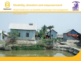
- This image shows a number of households in Shyamnagar Upazila, Satkhira District. They sit behind a small raised bank next to a major river – if the water rises due to the monsoon, tidal surges or storm surges the houses are likely to be damaged.
- This image shows the typical landscape in Asasuni
- This image shows a poster used for a mapping exercise of a self-help group in Asasuni. The poster shows the key buildings and roads in the village that self help group members would use to evacuate in the event of a hazard
- An image of a fishing pond and surrounding trees in Asasuni