
Recommended
More Related Content
What's hot
What's hot (20)
Similar to Satellite navigation and and how it works
Similar to Satellite navigation and and how it works (20)
More from wonderdome
More from wonderdome (20)
Recently uploaded
Recently uploaded (20)
Satellite navigation and and how it works
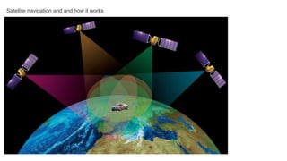
- 1. Satellite navigation and and how it works
- 2. Now to make use of this idea we should make corrections for the •Relativistic effects: as the clock in the stronger gravity on Earth will go at a different speed (slower) than the clock in the weaker gravity on the fast moving satellite! To improve the satellite navigation accuracy we should make fine corrections for the •Atmospheric effects: as the signal can be distorted when it travels through the Earth’s atmosphere. To check how the current atmospheric conditions in the area affect the signal, we can perform test measurements. All we need to do is to send a signal from the satellite to the ground station. Because we already know its location, the signal will give us the error value. This value can be then applied to correct the signal coming to the receiver. Of course, for the technique to work, we need the ground station to be as close to our receiver as possible. Therefore, the more stations across the globe, the better! Many other things can affect the signal. Solar storms and satellites configuration can attribute to the accuracy. The receiver’s position on Earth is also important, because trees, tunnels and tall buildings can block and mirror the signal.
- 3. Who provides satellite navigation services to the public? GPS Global Positioning System Developer: US Air Force Status: In operation since 1995. Opened for civilian use in 80s. Coverage: Global Number of satellites: 31 Altitude: 20 200 km Accuracy: 3.5 – 7.8 m
- 4. GLONASS Globalnaya Navigatsionnaya Sputnikovaya Sistema (it’s Russian for Global Satellite Navigation System) Developer: Russian Space Agency Roscosmos Status: Developed at the same time as GPS. In global operation since 2010. Coverage: Global Number of satellites: 24 Altitude: 19 100 km Accuracy: 5-10 m
- 5. Galileo Developer: European Space Agency ESA Status: Limited operation since 2016. The full cluster of satellites is expected to begin its operation in 2020. Coverage: Global Number of satellites: (expected) 30 satellites (27 active + 3 spares) Altitude: 23 222 km
- 6. NAVIC / IRNSS Indian Regional Navigation Satellite System Developer : Indian Space ISRO Status: Expected to begin its operation in 2018. Satellites in orbit but some have problems with atomic clock. Coverage: India and surrounding areas. Global coverage program is under development. Number of satellites: 7 (4 more will be added in the next 10 years) Altitude: 36 000 km Accuracy: (expected) 5-10 m on the land and better than 20 meters in the Indian ocean
- 7. Quazi-Zenith Satellite System Developer: Japan Aerospace JAXA Status: operational Coverage: Japan and surrounding areas Number of satellites: 4 operational and 3 more under development Altitude: 32 000 km – 40 000 km Accuracy: better than 1 meter
- 8. BeiDou Navigation Satellite System Developer: China National Space Administration CNSA Status: BeiDou-1 (Regional test cluster) was in operation 2000-2012. BeiDou – 2 (Global coverage cluster) is expected to be fully operational by 2020; 15 satellites are operating at the moment Coverage: BeiDou-1 China and surrounding areas. BeiDou-2 Global. Number of satellites: 4 (BeiDou-1) and 35 (BeiDou-2) Accuracy: better than 10 meters So which one is the best? GPS and GLONASS are the main global satellite navigation providers. GLONASS works on higher latitudes than GPS, but GPS gives a better accuracy worldwide. Some modern devices access both GPS and GLONASS satellites, which is great for us users! The Chinese BeiDou, once complete, might become a serious competition to GPS. But as far as it is compatible with GPS and GLONASS, it will provide an even better satellite coverage! May you always arrive to your destination! Questions? Comments? Let our mobile planetarium team know!