Essential Surveying Concepts, Types, and Classifications in 40 Characters
•
1 like•72 views

Surveying

Recommended
More Related Content
What's hot
What's hot (20)
Similar to Essential Surveying Concepts, Types, and Classifications in 40 Characters
Similar to Essential Surveying Concepts, Types, and Classifications in 40 Characters (20)
More from Waqas Khan
More from Waqas Khan (16)
Recently uploaded
Recently uploaded (20)
Essential Surveying Concepts, Types, and Classifications in 40 Characters
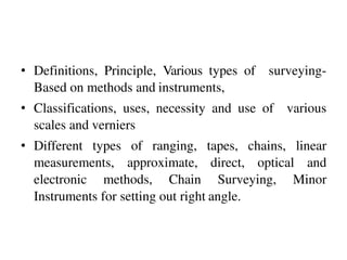
- 1. • Definitions, Principle, Various types of surveying- Based on methods and instruments, • Classifications, uses, necessity and use of various scales and verniers • Different types of ranging, tapes, chains, linear measurements, approximate, direct, optical and electronic methods, Chain Surveying, Minor Instruments for setting out right angle.
- 2. Surveying • “Surveying is the art of and science of determining the relative positions of various points or stations on the surface of the earth by measuring the horizontal and vertical distances, angles, and taking the details of these points and by preparing a map or plan to any suitable scale.
- 3. Objective of Surveying • The object of surveying is to prepare a map or plan to show the relative positions of the objects on the surface of the earth. The map or plan is drawn to some suitable scale. It also shows boundaries of districts states, and countries too. It features different engineering building roads railways dams canals etc.
- 6. Uses of Surveying The surveying may be used for following purposes: • To prepare a topographical map which shows hills, valleys, rivers, forests, villages, towns etc. • To prepare a cadastral map which shows the boundaries of fields, plots, houses and other properties.. • To prepare an engineering map which shows the position of engineering works such as buildings, roads, railways, dams, canals.
- 7. Uses of Surveying • To prepare a contour map to know the topography of the area to find out the best possible site for roads, railways, bridges, reservoirs, canals, etc. • Surveying is also used to prepare military map, geological map, archaeological map etc. • For setting out work and transferring details from the map on the ground.
- 8. Primary Divisions of Surveying We know that the shape of the earth is spheroidal. Thus the surface is obviously curved. Surveying is primarily divided into two types considering the curvature of the earths surface. • Plane Surveying • Geodetic Surveying
- 9. Primary Divisions of Surveying • Plain Surveying • The plain surveying is that type of surveying in which earth surface is considered as a plane and the curvature of the earth is ignored. In such surveying a line joining any two stations is considered to be straight. The triangle formed by any three points is considered as a plane triangle, and the angles of the triangle are considered as plain angles. • Surveying is carried out for a small area of less than 250 km2 . It is carried out by local or state agencies like R & B department, Irrigation department, Railway department.
- 10. Plain Surveying
- 11. Primary Divisions of Surveying Geodetic Surveying • The geodetic Surveying is that type of surveying in which the curvature of the earth is taken into account. It is generally extended over larger areas. The line joining any two stations is considered as curved line. The triangle formed by any three points is considered to be spherical and the angles of the triangle are considered to be spherical angles. Geodetic surveying is conducted by the survey of India Department and is carried out for a larger area exceeding 250 km2
- 14. Plain Surveying Vs Geodetic Surveying No. Plain Surveying Geodetic Surveying 1 The earth surface is considered as plain Surface. The earth surface is considered as Curved Surface. 2. The Curvature of the earth is ignored The curvature of earth is taken into account. 3 Line joining any two stations is considered to be straight The line joining any two stations is considered as spherical. 4. The triangle formed by any three points is considered as plain The Triangle formed by any three points is considered as spherical. 5. The angles of triangle are considered as plain angles. The angles of the triangle are considered as spherical angles. 6. Carried out for a small area < 250 km2 Carried out for a small area > 250 km2
- 15. Fundamental Principles of Surveying • Two basic principles of surveying are: • Always work from whole to the part, and • To locate a new station by at least two measurements ( Linear or angular) from fixed reference points.
- 16. Fundamental Principles of Surveying Always work from whole to the part: • According to the first principle, the whole survey area is first enclosed by main stations (i.e.. Control stations) and main survey lines. The area is then divided into a number of divisions by forming well conditioned triangles.
- 17. Work from Whole to the Part
- 18. Fundamental Principles of Surveying • The main survey lines are measured very accurately with precise survey instruments. The remaining sides of measured. The purpose of this method of working The triangle are is to control accumulation of errors. During measurement, if there is any error, then it will not affect the whole work, but if the reverse process is followed then the minor error in measurement will be magnified.
- 19. Fundamental Principles of Surveying • To locate a new station by at least two measurements ( Linear or angular) from fixed reference points. • According to the second principle the points are located by linear or angular measurement or by both in surveying. If two control points are established first, then a new station can be located by linear measurement. Let A & B are control points, a new point C can be established.
- 20. Fundamental Principles of Surveying • Following are the methods of locating point C from such reference points A &B. • The distance AB can be measured accurately and the relative positions of the point can be then plotted on the sheet to some scale. (a) Taking linear measurement from A and Bfor C. (b) Taking linear measurement of perpendicular from D to C. • (c) Taking one linear measurement from B and one angular measurement as∕ABC
- 21. Fundamental Principles of Surveying • Taking two angular measurement at A & Bas angles / CAB and /ABC. • Taking one angle at B as / ABC and onelinear measurement from A asAC.
- 23. Leveling • Leveling is a branch of surveying which deals with the measurement of relative heights of different points on, above or below the surface of the earth. Thus in leveling, the measurements (elevations) are taken in the vertical plane.
- 24. Leveling
- 25. Leveling
- 26. Classification of Surveying • Survey can be classified into various categories depending on methods used and nature of the field. • Classification Based on Instruments. • Chain Survey: • This is the simplest type of surveying in which only linear measurements are made with a chain or a tape. Angular measurements are not taken.
- 27. Chain Survey
- 28. Classification of Surveying • Compass Survey: • In Compass Survey, the angles are measured with the help of a magnetic compass. • Chain and compass survey: • In this survey linear measurements are made with a chain or a tape and angular measurements with a compass.
- 29. Compass Survey
- 30. Compass Survey
- 31. Compass Survey
- 32. Classification of Surveying • Plane Table Surveying • It is a graphical method of surveying in which field works and plotting both are done simultaneously. • Theodolite Survey: • In theodolite survey the horizontal angles are measured with the theodolite more precisely than compass and the linear measurements are made with a chain or tape.
- 38. Classification of Surveying • Tachometry Survey: • A special type of theodolite known as tachometer is used to determine horizontal and vertical distances indirectly. • Leveling Survey: • This type of survey is used to determine the vertical distances (elevations) and relative heights of points with the help of an instrument known as level.
- 42. Leveling Survey
- 43. Classification of Surveying • Classification Based on methods. Triangulation: • Triangulation is basic method of surveying, when the area to be surveyed is large, triangulation is adopted. The entire area is divided into network of triangles. Traversing: • A Traversing is circuit of survey lines. It may be open or closed. When the linear measurements are done with a chain and a tape and the directions or horizontal angles are measured with a compass or a theodolite respectively the survey is called traversing.
- 44. Triangulation
- 45. Traversing
- 46. Classification of Surveying • Classification based on Purpose • Geological Survey: • In this both surface and subsurface surveying are conducted to locate different minerals and rocks. In addition, geological features of the terrain such as folds and faults are located.
- 48. Classification of Surveying Mine Survey • Mine Survey includes include both surface and underground surveys. It is conducted for the exploration of mineral deposits and to guide tunneling and other operations associated with mining.
- 49. Mine Survey
- 50. Classification of Surveying • Archaeological Survey • It is conducted to locate relics of antiquity, civilization, kingdoms, forts, temples, etc. • Military Survey • It has a very important and critical applications in the military. Aerial surveys are conducted for this purpose. It is conducted to locate strategic positions for the purpose of army operations.
- 52. Military Survey
- 53. Classification of Surveying • Classification based on Nature of field • Land Survey • Land Survey is done on land to prepare plan and maps of a given area. Topographical, city and cadastral surveys are some of the examples of land surveying. • Hydrological Surveying • This survey is conducted on or near the body of water such as lake, river, coastal area. This Survey consists of locating shore lines of water bodies.
- 54. Land Survey
- 56. Classification of Surveying • Astronomical Survey • This survey is conducted for the determining of latitudes, longitudes, azimuths, local time, etc. for various places on earth by observing heavenly bodies ( sun or the stars). • Aerial Survey • An aerial survey is conducted from aircraft. Aerial cameras take photographs of the surface of the earth in overlapping strips of land. This is also known as photographic survey.
- 60. Aerial Survey
- 61. Plan and Maps • One of the basic objective of surveying is to prepare plans and maps. • Plan • A plan is the graphical representation to some scale, of the features on, near or below the surface of the earth as projected on a horizontal plane. The horizontal plane is represented by plane of drawing sheets on which the plan is drawn to some scale However the surface of the earth is curved it cannot be truly represented on a plane without distortion. In plane surveying the area involved are small, the earth‟s surface may be considered as plane and hence plan is constructed by orthographic projections. A plan is drawn on a relatively large scale.
- 62. Plan and Maps • Map • If the scale of the graphical projection on a horizontal plane is small, the plan is called a map. Thus graphical representation is called a plan if the scale is large while it is called a map if the scale is small. • On plan, generally only horizontal distances and directions or angles are shown. On topographical map, however the vertical distances (elevations) are also represented by contour lines.
- 63. WHAT IS CHAIN SURVEING ? • Chain surveying is the type of surveying in which only linear measurements are takenin the field. • This type of surveying is done for surveys of small extent to describe the boundaries of plot of land to locate the existing features on them.
- 66. PRINCIPAL OF CHAIN SURVEYING The principal of chain surveying is to divide the area into a number of triangles of suitable sides. As a triangles is the only simple plane of geometrical figure which can be plotted from the lengths of the three sides even if the angels are not known.
- 67. A network of triangles (triangulation) is preferred to in chain surveying. If the area to be surveyed is triangular in shape and if the lengths and sequence of its three sides are recorded the plane of area can be easily drawn.
- 68. TERMS RELATED WITH CHAIN SURVEYING
- 69. SURVEY STATIONS Surveystations are the points at thebeginning and at the end of the chain line.Theymayalso occur at anyconvenient position on the chain line. Suchstations maybe : Main stations Subsidiary stations Tie stations
- 70. (1) Main stations: Stations taken along the boundary of an area ascontrolling points known as‘main stations’. Thelines joining the main stations arecalled ‘main survey lines’. Themain survey lines should be cover the whole area to be surveyed.Themain stations are denoted by withletters A,B,C,D,etc.
- 72. (2)Subsidiarystations: Stations which are on the main survey lines or any other survey lines are known as ‘Subsidiary stations’. These stations are taken to run subsidiary lines for dividing the area into triangles , for checking the accuracy of triangles and for locating interiordetails. these stations are denoted by ‘ ‘ with lettersS1,S2, S3,etc.
- 73. (3) Tie stations : These are also subsidiary stations taken on the main survey lines. Lines joining the tie stations are known as ‘tie lines’. Tie lines are taken to locate interior details. The stations are denoted by ‘ ’ with letters T1, T2, T3, etc.
- 74. (4) BASELINE: The line on which the framework of the survey is built is known as the ‘base line’ . It is the most important line of the survey . Generally , the longest of the main survey line is considered as the base line. This line should be measured very carefully and accurately. In fig.BD is the base line.
- 75. (5) CHECK LINE: The line joining the apex point of a triangle to some fixed points on its base is known as the ‘check line’. It is taken to check the accuracy of the triangle . Sometimes this line is helps to locate interior details . In fig. CS1, AS2 are the checklines.
- 76. (6) TIE – LINE: A line joining tie stations is termed asatie line. It is run to take the interior details which are far away from the main lines and also to avoid long offsets. It canalso serve ascheck line. In Fig.T1T2is the tie line.
- 77. INTERACTION OF EMR WITH ATMOSPHERE AND EARTH SURFACE Electro-magnetic radiation (EMR) or energy interactions with atmosphere and with the earth surface play a vital role in remote sensing. Energy interactions with the atmosphere dictate the spectral regions through which only we can do the remote sensing which are known as spectral windows (the spectral regions where atmosphere is more or less transparent). ENERGYINTERACTIONINATMOSPHERE Irrespective of its source, all radiation detected by remote sensors passes through some distance, or path length, of atmosphere. The path length involved can vary widely. For example, space photography results from sunlight that passes through the full thickness of the earth's atmosphere twice on its journey from source to sensor. On the other hand , an airborne thermal sensor detects energy emitted directly from objects on the earth, so a single, relatively short atmospheric path length is involved. Because of the varied nature of atmospheric effects, wetreat this subject on a sensor-by-sensor. The atmosphere can have a profound effect on, among other things, the intensity and spectral composition of radiation available to any sensing system. These effects are caused principally through the mechanisms of atmospheric scattering and absorption. (A). SCATTERING: Atmospheric scattering is unpredictable diffusion of radiation by particles in the atmosphere. Scattering is the process where an atom, molecule or particle redirects energy.
- 78. TYPES OFSCATTERING 1.Rayleigh scattering – atmospheric atom 2.Mie scattering – aerosol 3.Non selective scattering – cloud
- 79. Rayleighscattering: Atmospheric gas or small molecule scatters radiation by a process known as Rayleigh scattering. Rayleigh scatter is common when radiation interacts with atmospheric molecules and other tiny particles that are much smaller in diameter than the wavelength of the interacting radiation. The effect of Rayleigh scatter is inverselyproportionalto the fourth powerofwavelength. Rayleigh scattering redirects the radiation about equal in all direction. Rayleigh scattering is responsible for blueskies andred sunsets. Miescattering: Another type of scatter is Mie scatter, which exists when atmospheric particle diameters essentially equal the energy wavelengths being sensed. Water vapour and dust are major causes of Mie scatter. This type of scatter tends to influences longer wavelengths compared to Rayleigh scatter. Although Rayleigh scatter tendsto dominateundermost atmosphericconditions,Miescatter is significant in slightly overcast ones. Examples: water vapor,smokeparticles, finedust
- 80. Nonselective scattering: A more b o thersome phenomenon is nonselective scatter, which comes about when the diameters of the particles causing scatter are much larger than the energy wavelengths being sensed. Water droplets, for example, cause such scater . They commonly have a diameter in the 5 to 100 µm (mocro meter, 10- 6 m) range and scatter all visible and Reflected IR wavelengths about equally. Consequently, this scattering is "nonselective" with respect towavelength. In the visible wavelengths (Approx. 0.4 to 0.7 µm ), equal quantities of blue, green, and red light are scattered, Making fog and clouds appear white. Examples: water droplets, ice crystals, volcanic ash, Smog
- 81. (B). ABSORPTION Atmospheric absorption results in the effective loss of energy to atmospheric constituents. This normally involves absorption of energy at a given wavelength. The most efficient absorbers of solar radiation in This regard is water vapour, carbon dioxide, and ozone. Because these gasses tend to absorb electromagnetic Energy in specific wavelength bands, they strongly influence "where we look" spectrally with any given remote Sensing system. The wavelength ranges in which the atmosphere is particularly transmissive of energy are referred to as atmospheric windows.
- 82. (C). TRANSMISSION: Amaterial transmits light when it allows the light to pass through it. Transparent materials allow all the light to pass through them so that you can easily see what is on the other side. Examples of transparent materials are glass, water, and air. Translucent materials scatter the light that passes through them. You can tell that something is on the other side, but you cannot see details clearly. Examples of translucent materials are wax paper, frosted glass, and some kinds of plastic. If the object is transparent, then the vibrations of the electrons are passed on to neighboring atoms through the bulk of the material and reemitted on the opposite side of the object. Such frequencies of light waves are said to be transmitted. If the object is opaque, then the vibrations of the electrons are not passed from atom to atom through the bulk of the material. Rather the electrons of atoms on the material's surface vibrate for short periods of time andthenreemit the energyas a reflected light wave.Suchfrequenciesof light are said to be reflected.
- 83. INTERACTIONSWITHEARTHSURFACEFEATURES Electromagnetic radiation that passes through the earth's atmosphere without being absorbed or scattered reaches the earth's surface to interact in different ways with different materials constituting the surface. When electromagnetic energy is incident on any given earth surface feature, three fundamental energy interactions with the feature are possible. There are three ways in which the total incident energy will interact with earth's surface materials. These are Absorption Transmission, and Reflection Absorption (A) occurs when radiation (energy) is absorbed into the target while transmission (T) occurs when radiation passes through a target. Reflection (R) occurs when radiation "bounces"off the target and is redirected. Howmuch of the energy is absorbed, transmitted or reflected by a material will depend upon: • Wavelength of the energy • Material constituting the surface, and • Conditionof the feature.
- 84. Reflection from surfaces occurs in twoways: 1.When the surface is smooth, we get a mirror-like or smooth reflection where all (or almost all) of the incident energy is reflected in one direction. This is called Specular Reflection and gives rise to images. 2.When the surface is rough, the energy is reflected uniformly in almost all directions. This is called Diffuse Reflection and does not give rise to images. Specular Reflection Diffuse Reflection Most surface features of the earth lie somewhere between perfectly specular or perfectly diffuse reflectors. Whether a particular target reflects specularly or diffusely, or somewhere in between, depends on the surface roughness of the feature in comparison to the wavelength of the incoming radiation.
- 85. If the wavelengths are much smaller than the surface variations or the particle sizes that make up the surface, diffuse reflection will dominate. For example, fine-grained sand would appear fairly smooth to long wavelength microwaves but would appear quite rough to the visible wavelengths. Vegetation: Achemical compound in leaves called chlorophyll strongly absorbs radiation in the red and blue wavelengths but reflects green wavelengths. Leaves appear "greenest" to us in the summer, when chlorophyll content is at its maximum. In autumn, there is less chlorophyll in the leaves, so there is less absorption and proportionately more reflection of the red wavelengths, making the leaves appear red or yellow (yellow is a combination of red and greenwavelengths).
- 86. The internal structure of healthy leaves act as excellent diffuse reflectors of near-infrared wavelengths. If our eyes were sensitive to near-infrared, trees would appear extremely bright to us at these wavelengths. In fact, measuring and monitoring the near-IR reflectance is one way that scientists can determine how healthy (or unhealthy) vegetation may be. Water: Longer wavelength visible and near infrared radiation is absorbed more by water than shorter visible wavelengths. Thus water typically looks blue or blue-green due to stronger reflectance at these shorter wavelengths, and darker if viewed at red or near infrared wavelengths.
- 87. If there is suspended sediment present in the upper layers of the water body, then this will allow better reflectivity and a brighter appearanceof the water. The apparent colour of the water will show a slight shift towards longer wavelengths. Suspended sediment (S) can be easily confused with shallow (but clear) water, since these two phenomenaappear very similar. Chlorophyll in algae absorbs more of the blue wavelengths and reflects the green, making the water appear more green in colour when algae is present. The topography of the water surface (rough, smooth, floating materials, etc.) can also lead to complications for water-related interpretation due to potential problems of specular reflection and other influences on colour and brightness. We can see from these examples that, depending on the complex make-up of the target that is being looked at, and the wavelengths of radiation involved, we can observe very different responses to the mechanisms of absorption, transmission, and reflection.
- 88. Spectral Response of Materials: Bymeasuring the energy that is reflected (or emitted) by targets on the Earth's surface over a variety of different wavelengths, wecan build up a spectral response for that object. The spectral response of a material to different wave lengths of EMRcan be represented graphically as a Spectral Reflectance Curve. It may not be possible to distinguish between different materials if we were to compare their response at one wavelength. But by comparing the response patterns of these materials over a range of wavelengths (in other words, comparing their spectral reflectance curves), we may be able to distinguish between them. For example, water and vegetation may reflect somewhat similarly in the visible wavelengths but are almost always separable in theinfrared. • Spectral response can be quite variable, even for the same target type, and can also vary with time (e.g. "green-ness" of leaves) and location.
- 90. Electromagneticspectrum • Distribution of the continuum of all radiant energies can be plotted either as a function of wavelength or of frequency in a chart known as the electromagnetic spectrum • It ranges from shorter wavelengths (including X-rays and gamma rays) to longer wavelengths (microwaves and radio waves)
- 92. • electromagnetic spectrum is the range of all possible frequencies of electromagnetic radiation • EMR extends over a wide range of energies or wavelengths or frequencies
- 93. • Radio: Your radio captures radio waves emitted by radio stations, bringing your favorite tunes. Radio waves are also emitted by stars and gasesin space. • Microwave: Microwave radiation will cook your popcorn in just a few minutes, but is also used by astronomers to learn about the structure of nearbygalaxies. • Infrared: Night vision goggles pick up the infrared light emitted by our skin. In space, infrared light helps us map the dust betweenstars.
- 94. • Ultraviolet: Ultraviolet radiation is emitted by the Sun and are the reason skin tans and burns. "Hot" objects in space also emit UV radiation • X-ray: A dentist uses X-rays to image your teeth, and airport security uses them to see through your bag. Hot gases in the Universealsoemit X-rays • Gamma ray:Doctors use gamma-ray in the treatment of dangerousdiseases.
- 97. • EMR in the range of 0.4 µm to 0.7 µm is known asthe visibleregion • white light contains amix of allwavelengths in the visibleregion
- 98. Visibleportion ofspectrum • Violet: • Blue: • Green: • Yellow: • Orange: • Red:0.620µm to 0.7µm 0.4µm to 0.446µm 0.446µm to 0.500µm 0.500µm to 0.578µm 0.578µm to 0.592µm 0.592µm to 0.620µm Amongtheseblue, greenandred arethe primarycolors
- 99. • S ir Isaac newton1666passedwhitelightthroughaglass prismandconcludedthatwhitelightisamixtureofseveral otherlights
- 100. • The principle behind this is that as radiation passes from one medium to another it bends this phenomenon iscalled refractiveindex
- 101. • The process of separating the constituent colours in white light isknownasdispersion
- 102. • The light which our eyes, our sensors can detect is part of the visible spectrum • Some remote sensing instruments also detects radiations invisible to our eyes. • Range of visible wavelength is from 0.4 µm to 0.7 µm • Longest visible wavelength is red and shortest is violet • Apart from these three, all other colors can be formed by combining blue, green and red in various proportions • EM spectrum spreads from cosmic rays to radio waves • Region of EM spectrum useful in remote sensing is from ultra violet to microwave
- 103. USES • Most parts of the electromagnetic spectrum are used in science for spectroscopic and other probing interactions, aswaysto study andcharacterizematter. • In addition, radiation from various parts of the spectrum has found many other uses for communications and manufacturing