What is LIDAR Illuminating Remote Sensing for Accurate Mapping and Other Applications
•
0 likes•3 views

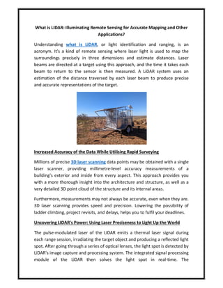
Understanding what is LiDAR, or light identification and ranging, is an acronym.

Recommended
Recommended
More Related Content
Similar to What is LIDAR Illuminating Remote Sensing for Accurate Mapping and Other Applications
Similar to What is LIDAR Illuminating Remote Sensing for Accurate Mapping and Other Applications (20)
Recently uploaded
Recently uploaded (20)
What is LIDAR Illuminating Remote Sensing for Accurate Mapping and Other Applications
- 1. What is LIDAR: Illuminating Remote Sensing for Accurate Mapping and Other Applications? Understanding what is LiDAR, or light identification and ranging, is an acronym. It's a kind of remote sensing where laser light is used to map the surroundings precisely in three dimensions and estimate distances. Laser beams are directed at a target using this approach, and the time it takes each beam to return to the sensor is then measured. A LiDAR system uses an estimation of the distance traversed by each laser beam to produce precise and accurate representations of the target. Increased Accuracy of the Data While Utilising Rapid Surveying Millions of precise 3D laser scanning data points may be obtained with a single laser scanner, providing millimetre-level accuracy measurements of a building's exterior and inside from every aspect. This approach provides you with a more thorough insight into the architecture and structure, as well as a very detailed 3D point cloud of the structure and its internal areas. Furthermore, measurements may not always be accurate, even when they are. 3D laser scanning provides speed and precision. Lowering the possibility of ladder climbing, project revisits, and delays, helps you to fulfil your deadlines. Uncovering LIDAR's Power: Using Laser Preciseness to Light Up the World The pulse-modulated laser of the LiDAR emits a thermal laser signal during each range session, irradiating the target object and producing a reflected light spot. After going through a series of optical lenses, the light spot is detected by LiDAR's image capture and processing system. The integrated signal processing module of the LiDAR then solves the light spot in real-time. The
- 2. communication link outputs the relative azimuth values and the distance between the target item and the LiDAR. Explore the Various Benefits of #D Scanning Services Producing millions of laser light beams and tracking their return is how 3D laser scanning operates. This will compute their three-dimensional coordinates and generate high-speed scans inside a single system. It uses the laser beams' reflection to digitally record the sizes and spatial connections of things. Laser scanning is crucial because it records millions of data points—including those invisible to the human eye—while scanning objects and site conditions. In summary, 3D scanning saves you time and money by gathering data points quickly, accurately, and consistently. Source