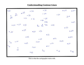
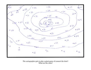
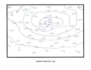
Contour lines on a map connect points of equal elevation, with the cartographer connecting elevation points at regular intervals, such as every 5 meters, to create contour lines showing the terrain's elevation and slope.
The document discusses the fluvial cycle and geological processes of rivers. It begins by introducing geomorphology and defining the fluvial cycle. It then describes the three stages of river development: youth, mature, and old age. Next, it explains the fluvial cycle and the geological actions of rivers, including erosion, transportation, and deposition. It provides details on various erosion features and processes, methods of transportation, and types of depositional features like deltas and alluvial fans. In concluding, the fluvial cycle represents the complete journey of a river from its initial to old stage through the geological processes of erosion, transportation, and deposition.
Reconnaissance for Hydrographic Surveying ProjectNzar Braim
Reconnaissance for Hydrographic
Surveying Project
This report talks about how the reconnaissance will be and it is effectively important the place that we survey and observation so the surveyor should prepare himself or herself for the project visiting site and site survey and planning and so on.
Observer visiting the site many times daily to see what is the situation and the condition and booking his or her notes recording them such as is the site ready to start the observation? Or is the site has safety to start? I mean replace safety conditions and also must have collected all this information and choose which instrument this site or this project and many other conditions should be considered after all above that I have mentioned he or she decides to start and beginning Project and surveying or not. This is the idea or this the outline recognizes.
1. Canals are constructed to carry water from rivers or reservoirs to irrigate fields. They are generally aligned along contours, ridges, or side slopes.
2. Contour canals follow elevation contours except for the required slope, allowing irrigation on one side. Ridge canals along dividing ridges allow irrigation on both sides.
3. Side slope canals run perpendicular to contours, parallel to natural drainage, avoiding the need for cross drainage structures. Proper geological investigation is important for determining appropriate canal alignments and designs.
Provides information needed by Sea Scouts to explain and demonstrate US Power Squadron plotting & labeling standards, in coordination with the deck log, using more restrictive Ship 378 standards.
Geological mapping involves systematically observing and recording rock exposures and structural features in the field to produce maps that show the spatial distribution and relationships of rock units. The document discusses different types of geological maps including reconnaissance, regional, detailed, and specialized maps. It also describes common mapping techniques such as traversing, exposure mapping, drilling, underground mapping, and photo-geology. Field equipment used in mapping includes hammers, chisels, compasses, clinometers, tapes, and notebooks.
The document discusses sequence stratigraphy, including concepts of accommodation space, causes of eustatic sea level change, and causes of tectonic subsidence. It also defines parasequences as conformable successions of genetically related beds bounded by marine flooding surfaces that typically shallow upwards. Parasequences represent asymmetric cycles and include facies deposited laterally together based on Walther's Law of facies change.
The document discusses coastal protection techniques. It begins by explaining the importance of coasts and the need for coastal protection due to erosion from storms and rising sea levels. It then describes hard and soft engineering techniques for coastal protection. Hard techniques include breakwaters, gabions, groynes, revetments, sea walls, and use rigid structures to defend coastlines. Soft techniques like beach nourishment, dune stabilization, and mangroves are more natural and sustainable approaches. The document provides details on various hard and soft techniques, their advantages and disadvantages. It concludes by discussing physical aspects of coastal protection like wave types, wave control through reflection, refraction, and breaking.
The document discusses various shoreline processes driven by wave motion. It explains that waves form as energy moves through water, with water particles moving in a circular pattern. As waves approach shallow water, they break due to friction, piling up water that rushes onto the shore and moves sediment. Waves typically approach the shore at an angle and carry sediment along the coast in a zig-zag pattern through longshore transport. Breaking waves can also transport sediment diagonally inland during swash before the sediment moves seaward during backwash.
Curves are used to gradually change the direction of transportation routes like roads, railways and pipelines. They connect straight tangents and are usually circular arcs. There are different types of curves classified based on their shape and connection of tangents like simple, compound, reverse etc. Elements like radius, deflection angle, length of curve, tangent length etc are used to design circular curves. Various surveying methods like Rankine's, two theodolite etc are used to establish curves on the ground based on their elements and principles. Compound curves consist of two simple circular curves bending in the same direction and joining at a common point of compound.
1) Floodplains form through erosion and deposition as rivers carry large loads of sediment and widen their valleys over thousands of years.
2) Levees are natural embankments that form along rivers when water moving out of the channel loses energy and deposits heavier sediments along the banks during flooding.
3) Repeated flooding and deposition over time cause levees and floodplains to build up layers of nutrient-rich alluvium soil.
Running water is the primary agent of erosion on Earth's surface, though its role is limited in some glaciated and desert areas. Streams erode through processes like abrasion, attrition, solution, and hydraulic action. As they flow downhill, their kinetic energy is used to transport sediment in suspension, saltation, traction, or solution. When the stream's energy decreases, such as when entering flatter terrain, sediment is deposited in features like point bars, floodplains, levees, meanders, and deltas. Meanders may be cut off over time, forming oxbow lakes.
1. Grouting, rock bolting, shotcrete/guniting, and cable anchorage are effective methods for improving rock mass properties.
2. Grouting involves injecting a liquid into cracks and fissures in rock to fill voids and strengthen the rock mass. Common grout materials include cement and chemical grouts.
3. Rock bolting reinforces unstable rock by drilling holes and anchoring steel bolts to take load off weak planes and increase shear resistance.
Geology and Petrography of Sandstone of Murree formation, Kuldana formation and Abbottabad formation Nakial and Dandli section sub Himalayas district Kotli, Azad Jammu Kashmir, Pakistan.
Overview:
The vertical alignment of a road consists of gradients(straight lines in a vertical plane) and vertical curves. The vertical alignment is usually drawn as a profile, which is a graph with elevation as vertical axis and the horizontal distance along the centre line of the road as the the horizontal axis.
Types of dams, geological considerations in site selection, Competency of Rocks to offer stable dam foundation, effect of geological structures on dam, selection of dam site, Reservoir, purpose of reservoir, influence of water table, geological structures, life of reservoir, geophysical studies
Highway engineering is an engineering discipline branching out from civil engineering. This subject involves the planning, design, construction, operation, and maintenance of roads, bridges, and tunnels to ensure safe and effective transportation of people and goods. There are certain geological conditions which should be considered while laying the highways. This module give those details in general.
Presentation on maneuvering and collision avoidance with special focus on large tonnage vessels.
Maneuverability limits and last moment maneuver are thoroughly shown in this material.
The document discusses key considerations for designing a shaft system for an underground mine. It addresses the interrelation of the shaft subsystem with other mine systems like ventilation, dewatering, and transport. The main elements of a shaft system include the headframe, winder house, shaft collar, fan drift, fittings and conveyances. Designing the shaft requires a multidisciplinary approach and consideration of functional requirements, geological conditions, operational parameters, and statutory regulations. Choice of the winding system, conveyance type, and winder location are important design decisions.
Introduction to Structural Geology-Patrice intro to_sgRoland Guillen
Charles Darwin developed an approach to scientific investigation based on building a model from facts and using that model to make testable predictions that could be verified through new data or experiments. If predictions were not verified, the model could be modified iteratively to strengthen it. This iterative process of building, testing, and modifying models leads to robust explanations for observations. Structural geology follows scientific methods to understand deformation structures based on field observations, data analysis, model building and testing. The discipline aims to characterize deformation features, kinematics, and driving forces at various scales from microns to kilometers.
A total station is an instrument that can measure both horizontal and vertical angles as well as slope distances. It combines an electronic theodolite with a distance measurement component. Total stations use electromagnetic waves or pulses to measure distances to a reflector or target. They can measure distances to a few kilometers with an accuracy of 2-3 mm at short ranges, decreasing to 4-5 mm at 1 km. Total stations are commonly used in surveying, civil engineering, and construction to define positions through combined angle and distance measurements.
The document provides information about tides, including what causes tides, the different types of tides, and tidal cycles. It discusses how the gravitational pull of the moon and sun cause tidal bulges in the oceans that result in high and low tides as the earth rotates through these bulges. Most coastal areas experience semi-diurnal tides with two high and two low tides each day, but some locations have diurnal or mixed tides. Spring tides occur during new and full moons when the sun and moon are aligned to produce higher high tides and lower low tides, while neap tides have a smaller tidal range.
Rivers are dynamic systems that continuously change their forms and patterns through processes of erosion, transportation, and deposition as influenced by factors like water discharge, sediment discharge, and human interference. River morphology is the study of river forms, patterns, and the processes that develop them. Understanding river morphology and hydrometric measurements is important for designing hydraulic structures, assessing sedimentation and environmental impacts, and understanding sediment transport processes.
Geophysical techniques work through applying one of several types of force to the ground, to measure the
resulting energy with use of geophysical equipment and infer the geology from this. Geophysics is generally
much quicker than the aforementioned methods, however, requires more data processing (oìce-based work)
to develop the geological picture. A great advantage of these methods is that certain instruments can be
attached to small aircraft for covering large areas during regional airborne surveys. This provides sparser
geological information, but can highlight potential metal anomalies on a county-country scale, which can be
followed up by more detailed, ground-based geophysical surveys. However, as the material is being tested
indirectly, there is no 100% guarantee of its conclusions; in addition to being susceptible to contamination by
many man-made metallic structures e.g. power-lines. Therefore, should geophysical surveys prove suìciently
interesting, drilling will be required afterwards to conêrm the accuracy of the results.
PPT on execution of 680 m long tunnel ensuring safety of the adjoining rail t...Rajesh Prasad
The said paper by Rajesh Prasad Executive Director RVNL has been published in IPWE international seminar held on 23/24-02-2018. The power point presentation nicely explains about how the technical challenges and administrative challenges addressed in completion of the tunnel while constructing a tunnel by the side of a railway tunnel with train operation in place and the entire area is affected by LWE activities.
The document describes a watercourse divided into three sections: an upper course, a middle course, and a lower course. The upper course is at the top, the middle course is in the middle, and the lower course is at the bottom.
Base level is the lowest level to which erosion by running water can take placeKennyboo Brown
Base level is the lowest point a river can erode down to, usually sea level. Changes in base level, from climate or tectonic activity, impact the river valley. A positive change, like rising sea levels, decreases the gradient and causes more deposition, flooding lower areas. A negative change, from falling seas or uplifting land, steepens the gradient and increases erosion rates, rejuvenating the river and creating features like knickpoints and terraces as the river adjusts its profile.
This newsletter from the ESA Library discusses upcoming events and initiatives at the library to help reduce student stress. It mentions that reading for as little as 6 minutes can significantly reduce stress. It thanks library volunteers for their hard work in organizing the collection. Upcoming events at the library include Great Soup on April 27th, Poetry in Voice documentary screenings, and the Festival of Trees event for the White Pine Reading Programme on May 12th.
The document provides instructions for fundraising participants to collect and submit donations for a hunger relief organization. It thanks online donors from the previous year for helping save costs so more money could be given to fight hunger. Participants are encouraged to collect sponsor donations online if possible, but paper forms are provided as an alternative. The forms collect sponsor information to issue tax receipts for donations of $15 or more. Participants are instructed to total the cash collected, write one cheque, and mail the package of forms and donations to the organization's address. A contributor to famine is drought, and drought is linked to climate change, so participants are encouraged to "go green" in their fundraising efforts.
This newsletter from the library at an arts school discusses upcoming events in December, including hot cider being served before school, musical performances around the Christmas tree, and a World War 1 documentary series. It also announces a contest for students to describe their favorite winter reads and be entered to win a free book. Upcoming events in January are noted, such as a visit from author Art Spiegelman and the first writers' festival at the school bringing in several authors for workshops.
This newsletter provides information about upcoming events at the Elizabeth Downie Media Library at Etobicoke School of the Arts. It discusses the conclusion of the school's Poetry in Voice competition and wishes luck to the student advancing to the national finals. It also promotes National Poetry Month and directs readers to the library's blog and collaborative poetry project. The newsletter then outlines writing workshops and literary events scheduled for May, including opportunities for student participation, as well as the return of the popular Great Soup fundraiser and new acquisitions to the graphic novel collection.
This document contains a list of book titles from two collections: CDEW (Contemporary Drama, Essays, Women's Writing) and FI (Fiction). There are over 50 books listed between the two collections, covering a wide range of genres including memoirs, novels, short stories, and dramas. The books explore various topics such as family relationships, social issues, historical fiction, and personal experiences. This high-level overview summarizes the type of information contained in the full book title list.
This document provides a list of books and other materials available at a library. It notes that some items displayed in red have been pulled from the shelves for display, and other items are either checked out or unavailable. The list includes over 100 titles organized by call number, covering topics such as Black history, civil rights leaders, memoirs, biographies, and literature by African American and Black Canadian authors.
This document provides a map of the lower level of the ESA Library. It lists the various subject areas and their call number ranges housed on this level, including adult and young adult fiction, short stories, memoir, biography, film, graphic novels, history, dance, music, philosophy & psychology, religion, social sciences, poetry, drama, literature, math & science, and visual arts. The map notes that music and music theatre materials are located on the upper level and that the map is not to scale.
The library newsletter provides updates on recent events and resources. It summarizes that the soup fundraiser raised $625 for typhoon relief efforts. It also promotes winter reading materials like the Canada Reads contenders and new arrivals. Students are encouraged to participate in reading programs and contests to win prizes and attend literary events. Additionally, the newsletter provides teaching tips and reviews of educational technology tools and apps.
This document provides a review sheet for a population study. It includes definitions of key demographic terms and concepts. It also asks questions about current global and Canadian population statistics, such as the total world population and the five most populous countries. Other questions cover population growth trends in Canada, the implications of an aging population, patterns of urbanization, and changes in immigrant demographics.
This document provides a sustainability review sheet with questions about key sustainability concepts such as the greenhouse effect, climate change, carbon sinks, ecological footprints, water consumption and pollution, waste generation and minimization, and the different impacts of climate change felt by developed and developing nations. Students are asked to define terms, list actions to reduce emissions and water usage, and identify reasons for future water shortages and ways to minimize individual ecological footprints. They are also prompted to consider perspectives on responsibility for waste and opinions on statements about water usage and climate change impacts on different countries.
The document provides a review sheet on maps and mapping, natural systems, and Canadian ecozones. It includes a list of terms to define related to maps, contour lines, map projections, and locations. It also lists concepts to understand about plate tectonics, landforms, ecozones, earthquakes, and population patterns in Canada. Questions assess identifying ecozones on a map of Canada, explaining plate tectonics, sketching plate boundaries, and answering questions to link locations and ecozones in Canada.
This document provides instructions and content outlines for a Canadian Geography final exam to be taken on June 20th at 1pm. The exam is broken into 4 parts worth a total of 90 marks: Part A involves mapping Canada and the world worth 20 marks, Part B contains 40 multiple choice questions about various geography topics, Part C requires short answers to 3 questions worth 15 marks total, and Part D is a long answer question worth 15 marks. The document provides details on the scope and requirements for each exam part.
This document provides instructions for students to design an isodemographic map of Canada as a culminating activity. Students will calculate population percentages and determine the number of squares to allocate to each province/territory based on a multiplier. They will then create a rough draft of the map and transfer it to a final copy, adding labels, colors, and a scale. The document outlines the timeline for in-class preparation periods and the final deadline.
This document provides instructions for students to design an isodemographic map of Canada as a culminating activity. An isodemographic map shows the relative size of provinces based on population rather than physical size. Students are provided with population data for each province and territory and steps to calculate percentages and determine the number of squares to allocate to each region on the map. Students will create a rough draft of the map in class and transfer it to a final copy to include colors, borders, a scale, and legend.
This rubric evaluates students on a isodemographic map assignment across several criteria on a scale from below level 1 to level 4. It assesses knowledge and understanding of places on the map being correctly identified and scaled. It examines thinking and inquiry by looking for evidence of pre-planning and creative thinking. It evaluates communication skills with criteria like an appropriate title, legend and scale. Creativity, aesthetics, and application of knowledge to new contexts are also considered.
How Many Universal Studios Are There in the World_.pdfTrending Blogers
Discover the world of Universal Studios with theme parks in five locations globally: Hollywood (USA), Florida (USA), Japan, Singapore, and Beijing (China). Each park offers unique attractions and immersive experiences based on popular films and TV shows. From the magical world of Harry Potter to thrilling rides like Transformers and Jurassic Park, Universal Studios parks provide unforgettable adventures for visitors of all ages.
Frank Woods: A Philosophy of Brutality and Brotherhood!Rodney Thomas Jr
#SSAPhilosophy #Philosophy #FrankWoods #CallOfDuty #GamingPhilosophy #Brotherhood #WarriorSpirit
In today's video, we explore the intense and gripping philosophy of one of the most resilient and tough-as-nails soldiers in the Call of Duty series—Frank Woods. Join me as we journey through the life and philosophy of Frank Woods, a character who embodies the raw power of brutality tempered by the unbreakable bonds of brotherhood. Whether you're a fan of Call of Duty or someone interested in the deeper philosophical themes of warfare and loyalty, this video will offer you a unique perspective on one of gaming's most iconic soldiers.
Link to video: https://youtu.be/CRudRp7HA-M
A Comprehensive Guide to Setting Up A1 IPTV for Your Home Entertainment.pdfXtreame HDTV
The digital age has revolutionized the way we consume content, and IPTV (Internet Protocol Television) stands at the forefront of this transformation. A1 IPTV is one of the leading services in this space, offering a wide range of channels and features that cater to the needs of modern viewers. This comprehensive guide will delve into everything you need to know about A1 IPTV, from its features and benefits to how it compares to traditional TV services.
Party Photo Booth Prop Trends to Unleash Your Inner StyleBirthday Galore
Are you planning an unforgettable event and looking for the best photo booth props to make it a memorable night? Party photo booth props have become essential to any celebration, allowing guests to capture priceless memories and express their personalities. Here, we'll explore the hottest party photo booth prop trends that will unleash your inner style and create a buzz-worthy experience with Birthday Galore!
For more details visit - birthdaygalore.com
Robert Downey Jr. Net Worth: A Comprehensive Analysisgreendigital
Introduction
Robert Downey Jr., synonymous with Hollywood success. has had a career marked by dramatic ups and downs. Downey's journey is remarkable, from his early days as a promising young actor to his well-documented struggles with addiction and his triumphant comeback in Iron Man. Central to this narrative is his financial success. This article delves into Robert Downey Jr. net worth, exploring how he amassed his fortune. the various income streams contributing to his wealth, and his financial management strategies.
Follow us on: Pinterest
Early Life and Career Beginnings
Childhood and Family Background
Robert Downey Jr. was born on April 4, 1965, in Manhattan, New York City. His father, Robert Downey Sr., was an influential filmmaker and actor. while his mother, Elsie Ann, was an actress. Growing up in a creative environment, Downey was exposed to the entertainment industry at a very young age, appearing in his father's films as early as age five.
Breakthrough in the 1980s
Downey's career began in earnest in the 1980s when he joined the cast of Saturday Night Live. His early film roles in movies like Weird Science (1985) and Less Than Zero (1987) showcased his talent and potential. Despite his initial success, these early years were also marked by personal challenges. Particularly his struggles with substance abuse.
The Downfall and Recovery
Struggles with Addiction
The 1990s were a tumultuous period for Downey. Despite critical acclaim for roles in films such as "Chaplin" (1992), for which he received an Academy Award nomination, his career was derailed by legal troubles related to his drug addiction. Frequent arrests and stints in rehab created an image of an actor whose potential was being overshadowed by his demons.
Comeback and Redemption
The early 2000s marked the beginning of Downey's remarkable comeback. With the support of friends and family and a strong will to overcome his addictions. he gradually rebuilt his career. Key to this resurgence was his role in the TV series Ally McBeal, which not only earned him a Golden Globe but also proved that he still had the talent and appeal needed for Hollywood stardom.
The Marvel Era and Explosive Financial Growth
Casting as Iron Man
2008 was a pivotal year for Downey, as he was cast as Tony Stark/Iron Man in the Marvel Cinematic Universe (MCU). This role would redefine his career and boost Robert Downey Jr. net worth. Marvel Studios took a risk by casting him, but it paid off as "Iron Man" (2008) became a critical and commercial success.
Earnings from the Marvel Cinematic Universe
Downey's portrayal of Iron Man became iconic. Leading to roles in many MCU films, including the "Avengers" series. His compensation for these films varied significantly, starting with a modest (by Hollywood standards) $500,000 for the first "Iron Man" movie. But, his earnings skyrocketed as the MCU grew and his role expanded. For example, Downey reportedly earned $50 million for "The Avengers" (2012) a
SERV is the ideal spot for savory food, refreshing beverages, and exciting entertainment. Each visit promises an unforgettable experience with daily promotions, live music, and engaging games such as pickleball. Offering five distinct food concepts inspired by popular street food, as well as coffee and dessert options, there's something to satisfy every taste. For more information visit our website: https://servfun.com/
So far, no details are known about Darby Galen’s career. She is not old enough to work yet. Currently, Darby focuses on her academic studies rather than making plans for his future career.
As a result, no one knows how much money it is worth. However, Patrick Dempsey’s net worth is projected to be around $80 million as of February 2023, as of this date.
The fact that Darby Galen Dempsey is related to Patrick Dempsey is what makes her best known. Darby was also born in Los Angeles, California on February 1, 2007. In 2020, Darby will turn 13 years old. She is Aquarius by birth sign. Her twin brother Sullivan Dempsey is also an actor.
Similarly, Darby Galen Dempsey is listed as the most famous celebrity on Wiki Famous People. Jillian Fink, Patrick Dempsey’s second wife, is Darby’s mother. Patrick Dempsey’s first wife was Rochelle “Rocky” Parker. Rocky, Patrick’s first wife, is an actress and acting teacher; However, the two divorced in 1994.
Darby’s parents, Patrick and Jillian, married in 1994. Together, Patrick and Jillian Fink are the parents of three children. Tallulah Fyfe and Sullivan Patrick, twins, are Darby’s siblings. Patrick founded the Patrick Dempsey Center, a cancer center at Central Maine Medical Center, in addition to his acting career. When Patrick’s mother was diagnosed with ovarian cancer and experienced severe suffering as a result, Patrick was motivated to find the center.
Darby Galen’s father is a well-known American actor who also drives racing cars. In Pastor’s film “McDreamy,” he plays Derek, a neurologist. The character of Darby’s father in the romantic thriller Grey’s Anatomy is well known. 2005 marked the year Darby’s father made his theatrical debut. In addition, the program is still on the air. In the 1980s, Darby’s father Patrick was the most sought-after and successful performer, and every director and producer wanted to collaborate with him. He has appeared in numerous films and television shows.
Darby’s father, Patrick, appeared in several major films during this time, such as “Can’t Buy Me Love” in 1987 and “Loverboy” in 1989. The wildly popular mystery horror film Scream 3 featured Darby’s father, Mark Kincaid, in 2000. The father is also a racing enthusiast. Darby’s father is a car fanatic who likes to race, drive sports vehicles, and collect old cars.