Deschutes Land Trust Nature Night: Geology of Central Oregon's CascadesDesLandTrust
Volcanic activity has occurred in Central Oregon for the past 40 million years, and will likely continue in the future. The volcanoes scattered throughout Central Oregon make up one of the most active and diverse sections of the entire Cascade range. Join geologist Daniele McKay to explore the history of these volcanoes, from explosive eruptions to quiet lava flows. We'll examine deposits left behind by ancient volcanoes, and consider what future volcanic activity in Central Oregon might look like.
This slideshare is my field assignment for Geology 103, Professor Lawler. It shares pictures and information about the Thunder Mountain area of California, near Kirkwood.
·
archaeocyathid
o
Cambrian - sessile, reef-building marine organisms of warm tropical and subtropical waters that lived during the early (lower) Cambrian period.
·
bioturbation
o
Cambrian - the reworking of soils and sediments by animals or plants. Its effects include changing texture of sediments (diagenetic), bioirrigation and displacement of microorganisms and non-living particles. Common bioturbators include annelids and bivalves (mussels, clams, gastropods).
·
Burgess Shale
o
Cambrian - located in the Canadian Rockies of British Columbia, is one of the world's most celebrated fossil fields. It is famous for the exceptional preservation of the soft parts of its fossils. At 505 million years (Middle Cambrian) old, it is one of the earliest fossil beds containing soft-part imprints.
·
Cambrian explosion
o
Cambrian - the relatively rapid appearance, around 530 million years ago, of most major animal phyla, as demonstrated in the fossil record, accompanied by major diversification of organisms
·
Iapetus Ocean
Cambrian/Ordovician - Precursor to the Atlantic. An ocean that existed in the Neoproterozoic and Paleozoic eras of the geologic timescale (between 600 and 400 million years ago). The ocean disappeared with the Caledonian, Taconic and Acadian orogenies, when these three continents joined to form one big landmass called Laurussia.
maturity Cambrian
·
Paleozoic Era
o
Cambrian - the earliest of three geologic eras of the Phanerozoic Eon, spanning from roughly 541 to 252.2 million years ago. It is the longest of the Phanerozoic eras, and is subdivided into six geologic periods (from oldest to youngest): the Cambrian, Ordovician, Silurian, Devonian, Carboniferous, and Permian.
·
passive margin
o
Cambrian - the transition between oceanic and continental crust which is not an active plate margin. It is constructed by sedimentation above an ancient rift, now marked by transitional crust. Continental rifting creates new ocean basins.
·
trilobite
o
Cambrian - extinct marine arthropods that form the class Trilobita. Trilobites form one of the earliest known groups of arthropods. Trilobites finally disappeared in the mass extinction at the end of the Permian about 250 million years ago. The trilobites were among the most successful of all early animals, roaming the oceans for over 270 million years.
·
bentonites
o
Ordovician - essentially impure clay consisting mostly of montmorillonite. Bentonite usually forms from weathering of volcanic ash, most often in the presence of water. However, the term bentonite, as well as a similar clay called tonstein, has been used to describe clay beds of uncertain origin.
·
Cincinnati arch
o
Ordovician - when continents crashed together during the two orogeny's you have the Appalachian mountains and then a down drop into the Appalachian basin going west and then going west the next rise is the Cincinnati arch and the next basin is the Illinois basin.
epeir.
Running head: DETAILED GEOLOGICAL TRIP REPORT
1
DETAILED GEOLOGICAL TRIP REPORT
2
Detailed Geological Trip Report
Name
Institution Affiliation
Detailed Trip Report: First Part
7:45 a.m. We departed from Campus.
We drove north on Highway 101. As we continued north through the Highway, we passed through Yachats, a town that is approximately 75 miles. Just on the left past the Adobe Motel was the turn-off to Smelt Sands Beach which was our first stop. ( that’s all copied)
Stop 1: Smelt Sands Beach.
Smooth and brown rocks are molded together by wet beach sand. The sand is, however, coarse with contents including, quartz, basalt, shell pieces, serpentine and agates. The rock forming the base rock formation is present in the sand signifying the rock is broken down by erosion.
Different rocks are also exposed and are believed to be from the Cenozoic Era. They are featured as part of the Yachats Basalt and are Late Eocene (36-40 million years) in age. These rocks were formed as a result of the cooling of magma from a series of eruptions ( this is all copied from that cheater essay.. not hard to tell see I told you… KEEP This I will alter (Alt and Hyndman 1978).
There is the existence of a Pleistocene terrace where the town of Yachats is built. The terrace was probably formed when the sea level was lower, and its deposit is 10,000 to 1.8 million years old. It cuts into the Yachats basalt sequence (Snavely, 1980). Its present level, which is above, the present sea level, is attributed to either the rise of land due to tectonic activity or dropping of the sea level. It is, however, difficult to know where the uplift of the land is possible in such an active coastline. The Smelt Sands Beach is located to the South of the start of Yaquina formation. A basalt flow is found at this spot. It lies beneath the Pleistocene terrace. This basalt is about 40 million years old. The Pleistocene, on the other hand, is about 1.8 years old. What happened between the formation of the basalt and the Pleistocene is not known yet. However, some researchers speculate that land movement could have occurred which led to dropping of the sea level or rising of the land. The whole town of Yachats has been built on this beach terrace.
Information about the town of Yachats indicates that much is of it occurs in a zone that prone to tsunami if another Cascadia subduction occurs. The part of the town, which is not, in the tsunami zone is found on the hillside. However, this part also risks destruction from the tsunami-causing earthquake. Studies carried out by researchers indicate 50m of beach would retreat in this region should a cascadia subduction occur (Snavely, 1980). This means that the biggest part of the Yachats town would be destroyed considering that most of the premises in the town, which include shops, hotels and residential houses are within a distance of 50m from the water. Plants found in this region include bog anemones and gold-eyed grasses..
Plate Tectonics is the driving force of geologic structures th.docxrandymartin91030
Plate Tectonics is the driving force of geologic structures that shape the world that we live in. The
first indication that continents might have been linked physically took place as soon as there was
mapping. It was known by the sixteenth and seventeenth century that the continents fitted together like
pieces of a puzzle. This and other proofs listed below lead to the concept of continental drift, that the
large continents had once been linked together. The scale movements of continents across the across
the surface of the planet was mind boggling.
By the close of the nineteenth century the geologist Edward Suess postulated that the southern
continents were joined together. This was from evidence seen by fossil animal distribution. Ancient life
forms have ranges just as modern animals. Tigers are found in India and Siberia, not in North America.
These ancient animals couldn’t get from South America to Africa, from Antarctica to Australia to India.
There were rock layers both sedimentary and igneous that were continuous on all of the five continents.
He christened this large continent Gondwanaland.
In 1915 Alfred Wegener wrote a book on continental drift. He proposed another super continent
called Pangaea. This continent included all of the modern continents. His mechanism for the movement
of the continents was that the continents moved through ocean crust, drifting until they joined then
breaking apart again. Wegener and others argued for their evidence pointing out rock similarities
type, similarities in rock trends and ages using all of the information gathered from Steno's laws and
fossil assemblages. They also showed that certain distant continents had similar plants and animals that
entered a different evolutionary path after the continents separated. An example of this is the fresh
water fish the Arowana found in both South America and Australia. Another example of this is the large
amount of marsupial
fossils found in South
America and Australia.
Placental mammals
were the dominant
mammalian life forms
in Eurasia, North
America and Africa.
Only in South America
and Australia were
marsupial fossils
dominated. It wasn't
until 3 million years ago
North and South
America joined
allowing placental
mammals to gain
dominance in South America. Despite this evidence Wegener and his followers mechanism for
continental movement was badly flawed. They proposed that the tidal forces from the Sun and Moon
like the tides in the ocean. This force is much too weak to move a continent so the theory was rejected.
Fossil plants and animal distribution on southern continents
In 1928 a geologist Arthur Holmes proposed the convection currents split the continents and that
these currents were in the mantel. Remember the knowledge of a mantel was already known at this
time. Ironically this was a mechanism had been proposed by Benjamin Franklin in 1782. Many
geologi.
On a private trip down the Colorado River with her family, 11 year old Chloe Tippett kayaks, rafts, paddle boards, and ultimately documents what she learns about geology for a school science project.
Seminar of U.V. Spectroscopy by SAMIR PANDASAMIR PANDA
Spectroscopy is a branch of science dealing the study of interaction of electromagnetic radiation with matter.
Ultraviolet-visible spectroscopy refers to absorption spectroscopy or reflect spectroscopy in the UV-VIS spectral region.
Ultraviolet-visible spectroscopy is an analytical method that can measure the amount of light received by the analyte.
This pdf is about the Schizophrenia.
For more details visit on YouTube; @SELF-EXPLANATORY;
https://www.youtube.com/channel/UCAiarMZDNhe1A3Rnpr_WkzA/videos
Thanks...!
Nutraceutical market, scope and growth: Herbal drug technologyLokesh Patil
As consumer awareness of health and wellness rises, the nutraceutical market—which includes goods like functional meals, drinks, and dietary supplements that provide health advantages beyond basic nutrition—is growing significantly. As healthcare expenses rise, the population ages, and people want natural and preventative health solutions more and more, this industry is increasing quickly. Further driving market expansion are product formulation innovations and the use of cutting-edge technology for customized nutrition. With its worldwide reach, the nutraceutical industry is expected to keep growing and provide significant chances for research and investment in a number of categories, including vitamins, minerals, probiotics, and herbal supplements.
THE IMPORTANCE OF MARTIAN ATMOSPHERE SAMPLE RETURN.Sérgio Sacani
The return of a sample of near-surface atmosphere from Mars would facilitate answers to several first-order science questions surrounding the formation and evolution of the planet. One of the important aspects of terrestrial planet formation in general is the role that primary atmospheres played in influencing the chemistry and structure of the planets and their antecedents. Studies of the martian atmosphere can be used to investigate the role of a primary atmosphere in its history. Atmosphere samples would also inform our understanding of the near-surface chemistry of the planet, and ultimately the prospects for life. High-precision isotopic analyses of constituent gases are needed to address these questions, requiring that the analyses are made on returned samples rather than in situ.
Richard's entangled aventures in wonderlandRichard Gill
Since the loophole-free Bell experiments of 2020 and the Nobel prizes in physics of 2022, critics of Bell's work have retreated to the fortress of super-determinism. Now, super-determinism is a derogatory word - it just means "determinism". Palmer, Hance and Hossenfelder argue that quantum mechanics and determinism are not incompatible, using a sophisticated mathematical construction based on a subtle thinning of allowed states and measurements in quantum mechanics, such that what is left appears to make Bell's argument fail, without altering the empirical predictions of quantum mechanics. I think however that it is a smoke screen, and the slogan "lost in math" comes to my mind. I will discuss some other recent disproofs of Bell's theorem using the language of causality based on causal graphs. Causal thinking is also central to law and justice. I will mention surprising connections to my work on serial killer nurse cases, in particular the Dutch case of Lucia de Berk and the current UK case of Lucy Letby.
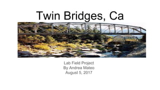
2. Twin Bridges, CA
This is an area outside of South Lake Tahoe. Where I spend some of my
summer days hiking or swimming in the river.This is an area where the
American river runs through the Sierra Nevada mountains.
3. Sierra Nevada Mountains
Once an ocean covered this area. Beneath the
sea floor movement from the plate tectonics
would create the Sierra Nevada mountains.
These rocks come from sedimentary rocks that
can be dated all the way back to the Cambrian
period.These mountains were formed by
deformation of the crust causing underground
pressure.During the Paleozoic Era the rocks
would rise to the surface eventually the rock
mass would break away from each other
causing a fault. Where one side rises and the
other side sinks down. This is the formation of a
block mountain..
http://www.sierrahistorical.org/geology-of-the-sierra-nevada/
4. Lovers Peak
.About 12,000 years ago this part of the mountain
experienced major erosion.There was a glaice that
split the peak in half causing permanent reshaping of
the landscape. This happened because this area was
fully glaciated during glacial cycles and then
deglaciated during the interglacial times(ulmer, 2012).
Read more at: https://phys.org/news/2012-02-mountain-ranges.html#jCp
5. These mountain peaks are made of rocks called Batholiths large body of igneous
rock formed beneath the Earth’s surface by the intrusion and solidification of
magma.
www.britannica.com/science/batholith
6. American Black Bear
The bears found in the Sierra Nevada mountains are
Black Bears.
So where is the beginning of time for bears? It started
about thirty to forty million years ago. With a small
doglike mammal called Miacids. This was a smaller
animal with a long body and wide claws. He is the
ancestor of the bear, but also the wolf, jackal, coyote
and fox, jackal, and hyena. This animal became extinct
during the Pliocene. Over millions of years evolved into
a canine ancestor bringing us closer to the first bear
called Urasvus also known as the bear-dog.
http://www.bearsinmind.org/Page/The-evolution-of-bear-specieshttp://www.amatras.com/history_prehistoric.htm
7. In North America there have been
fossils found that can be “ traced back
to the oldest genus, the Ursavus, which
was roughly the size of a sheepdog
(Bears in Mind).This animal became
extinct about eight million years
ago.These animals had strong curved
claws for tearing apart insect mounds,
food and climbing trees. There teeth
were evolving with canine in the front
and flat molars in the back for eating
plants. http://www.amatras.com/history_prehistoric.htm
8. The fossil record has
discovered that the Asiatic and
Black bear have the closest
relation. In today's world there
are eight bear species Asiatic
Bear, Brown Bear, Black Bear,
Grizzly Bears, Black Bears,
Sun Bears, Polar Bears, and
Sloth bear that all descended
from the bear-dog. Each bear
has been able to adapt to their
environment. However the
Polar bear has become
endangered. .
https://www.nature.com/articles/srep46487
9. Snow Plant
Snow plant has no chlorophyll; it derives
nutrition from fungi underneath the soil,
and for this reason the plant is called
"mycotrophic". These fungi are the
mycorrhizae(Gauna).
https://www.fs.fed.us/wildflowers/plant-of-the-
week/sarcodes_sanguinea.shtml
11. Igneous Granite Rock
This is a rock that I found walking down towards the river from Lover’s Peak. I can
tell its granite because it looks identical to my kitchen counter. This is one of the
most common rocks found on the earth's surface. This is an intrusive rock that
formed crystallization of magma below the earth’s surface. The rock is mostly
made of two minerals quartz and feldspar.
http://geology.com/rocks/granite.shtml
12. Metamorphic Gneiss
I found this rock in the river. I love the way this rock looks when it is wet.You
can really see the different shades of brown. I believe this rock is a Gneiss. It”
usually forms by regional metamorphism at convergent plate boundaries. It is a high-grade
metamorphic rock in which mineral grains recrystallized under intense heat and
pressure”(Gneiss).
Gneiss. (n.d.). Retrieved August 07, 2017, from http://geology.com/rocks/gneiss.shtml
13. Sedimentary
Sedimentary rocks are formed from overburden pressure as particles of sediment
are deposited out of air, ice, or water flows carrying the particles in suspension.
https://en.wikipedia.org/wiki/Sedimentary_rock
14. Steno’s Laws
Law of Superposition-In a sequence of rock with the oldest layer on the bottom
Law of Original Horizontality-Layers of sediment deposited by gravity into flat
layers which can be found bottom of oceans and lakes.
Law of Cross-Cutting -If a rock layer is cut by a fault or igneous intrusion, the rock that is
cut must be older than the layer that cuts it.
Law of Lateral Continuity-Rock layers will extend outwards until the environment that
produced them changes.
Vermont, U. O. (n.d.). University of Vermont. Retrieved August 07, 2017, from https://www.uvm.edu/perkins/evolution/qanda/?Page=time%2Frelative.html&SM=time%2Ftimemenu.html
15. References
Geology Of The Sierra Nevada. (n.d.). Retrieved August 05, 2017, from http://www.sierrahistorical.org/geology-of-the-sierra-nevada/
Fault-Block Mountains. (2017, May 04). Retrieved August 05, 2017, from https://www.universetoday.com/29823/fault-block-mountains/
Formation of Fault Block Mountains. (n.d.). Retrieved August 05, 2017, from http://www.mountainprofessor.com/fault-block-mountains.html
Batholith. (n.d.). Retrieved August 05, 2017, from http://www.britannica.com/science/batholith
How mountain ranges get their shape. (n.d.). Retrieved August 05, 2017, from https://phys.org/news/2012-02-mountain-ranges.html
Bratpack, B. I. (n.d.). The evolution of bear species. Retrieved August 05, 2017, from http://www.bearsinmind.org/Page/The-evolution-of-
bear-species
"Miacis". (n.d.). Retrieved August 05, 2017, from http://www.amatras.com/history_prehistoric.htm
(n.d.). Retrieved August 05, 2017, from https://flexiblelearning.auckland.ac.nz/rocks_minerals/rocks/gneiss.htm
lGranite. (n.d.). Retrieved August 05, 2017, from http://geology.com/rocks/granite.shtml
Sedimentary rock. (2017, July 30). Retrieved August 05, 2017, from https://en.wikipedia.org/wiki/Sedimentary_rock
Vermont, U. O. (n.d.). University of Vermont. Retrieved August 05, 2017, from
https://www.uvm.edu/perkins/evolution/qanda/?Page=time%2Frelative.html&SM=time%2Ftimemenu.html