The document discusses plans for the Central Healdsburg Avenue area. It describes an ongoing 10-month study led by an interdisciplinary team to develop a transportation plan for the area. The study area covers about 80 acres at the entry to Healdsburg. Tonight's agenda includes an introduction, a forum on transportation and mobility, a question and answer session, and confirming next steps. The document provides details on various aspects of the transportation planning process, including levels of service, complete streets, connectivity, and considerations for planning transportation around a train station. It also discusses potential improvements to US 101 interchanges and the 5-way intersection using modern roundabouts.
Title: Level of Service F for Grade A Streets
Track: Prosper
Format: 90 minute panel
Abstract: Relying solely on Level of Service criteria for street design, which evaluates vehicle congestion, leads to poor outcomes on many of our roadways. LOS F, far from a failure, creates opportunities to reallocate roadway space for more livable street designs. In this session, learn about projects in Cambridge and San Francisco that overcame opposition and generated community support in prioritizing better bicycling and walking over vehicle capacity during the peak hour of travel.
Presenters:
Presenter: Michael Sallaberry San Francisco Municipal Transportation Agency
Co-Presenter: Jeffrey Rosenblum City of Cambridge, MA
The poor quality of our streets causes over 160 deaths every year. There is a dire need for street design guidelines that ensure high quality streets through standardization of essential street elements
Title: Aloha Streets: Complete Streets and Complete Communities in Hawai`i
Track: Connect
Format: 90 minute panel
Abstract: Residents and visitors of Hawai'i expect paradise, but find traffic. Find out how communities at different scales in the state are expanding viable transportation options and building complete, transit-oriented cities and towns.
Presenters:
Presenter: Evan Corey Nelson\Nygaard
Co-Presenter: Mark Garrity City of Honolulu Transportation Services
Co-Presenter: Michael Moule County of Kauai
Yesterday saw Gehl Architects, commissioned by Glasgow City Council, unveil the draft Regeneration Framework for the Sauchiehall and Garnethill area of the city centre.
Designing & Planning for Cycling, Phil Jones & Adrian LordDesign South East
Presentation on Design and Planning for cycling from the Designing and Planning for Cycling workshop at MADE on 19th May 2015. Presentation by Phil Jones and Adrian Lord, Phil Jones Associates.
This presentation was delivered by Peter Jones from University College London on 2nd October 2015 and highlighted the importance of considering Link and Place when improving street design.
This presentation highlights the importance of Roadspace Allocation within transport planning and illustrates how to develop a successful Roadspace Allocation Framework. Further to this the presentation gives an insight to understanding and meeting user requirements. It then progresses to utilise various case studies in Birmingham to further demonstrate how these frameworks can be put into practice.
This set of slides explains current street design issues, and how "designed" streets are essential - who can do that and what else is required to make this happen in Indian cities.
This proposed project is intended to improve traffic circulation and access to properties along the Loop 250 frontage road. The extension of Beal Parkway would provide a new connection to Thomason Drive and will reduce traffic in adjacent neighborhoods. A roundabout is also proposed at the intersection of Thomason Drive and Illinois Avenue to provide a safer interchange of traffic between the three roadways.
http://www.gaplanning.com/traffic-engineering-roundabouts/
Here's a presentation from Williams & Associates, and Athens, GA based transportation and traffic control engineering firm. In this video and slideshow, we present the Top 7 Advantages of Roundabouts in Traffic Control.
Energy Efficiency: Thinking beyond Building EnvelopesTiE Bangalore
Bridging gaps in non-motorised mobility in private housing developments.
TiE SIG Cleantech: Sustainable Apartments.
Presentation by Sanjay Sridhar
Strategy Head, Urban Development
World Resources Institute
Woodward Corridor Neighborhood Bicycle Network - 2016 TAP AwardJustin Lyons
A summary of a recent grant application I wrote for the City of Ferndale and 5 other communities for a 17 mile bicycle route. The project was awarded over $200k in grant money and will be completed in late 2016.
Presentation by Rick Hall, PE at Great Streets-Healthy Communities program hosted by ULI Memphis and the University of Memphis Partnership for Active Community Environments in Memphis, TN on April 21, 2010.
Portland's Complete Streets Policy - GSMSummit 2014, Bruce HymanGrowSmart Maine
Why plan for growth and change, when it seems so much easier to simply react?
When there is a distinct and shared vision for your community - when residents, businesses and local government anticipate a sustainable town with cohesive and thriving neighborhoods - you have the power to conserve your beautiful natural spaces, enhance your existing downtown or Main Street, enable rural areas to be productive and prosperous, and save money through efficient use of existing infrastructure.
This is the dollars and sense of smart growth.
Success is clearly visible in Maine, from the creation of a community-built senior housing complex and health center in Fort Fairfield to conservation easements creating Forever Farms to Rockland's revitalized downtown. Communities have options. We have the power to manage our own responses to growth and change.
After all, “Planning is a process of choosing among those many options. If we do not choose to plan, then we choose to have others plan for us.” - Richard I. Winwood
And in the end, this means that our children and their children will choose to make Maine home and our economy will provide the opportunities to do so.
The Summit offers you a wonderful opportunity to be a part of the transformative change in Maine that we’ve seen these gatherings produce. We encourage you to consider the value of being actively involved in growing Maine’s economy and protecting the reasons we choose to live here.
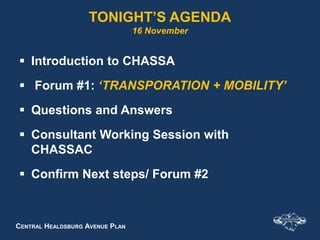
1. CENTRAL HEALDSBURG AVENUE PLAN
TONIGHT’S AGENDA
16 November
Introduction to CHASSA
Forum #1: ‘TRANSPORATION + MOBILITY’
Questions and Answers
Consultant Working Session with
CHASSAC
Confirm Next steps/ Forum #2
2. CENTRAL HEALDSBURG AVENUE PLAN
What is CHASSA?
10 Month Study initiated by the City Redevelopment
Agency
About 80 acres - entry to Healdsburg
3. CENTRAL HEALDSBURG AVENUE PLAN
Who is Doing the Study?
An inter-disciplinary team comprised of:
• Urban designers
• Economic development specialists
• Transportation planners
• Environmental consultants
• Civil engineers
• Landscape architects
• Specialists in sustainability, CEQA and
community outreach
5. CENTRAL HEALDSBURG AVENUE PLAN
Transportation Planning &
Traffic Engineering
What we do
Collaborate with team
Plan mobility and accessibility
Analyze effects of land use
Forecast travel “demand”
Assess travel patterns
Assess streets and intersections
Design multi-modal facilities
Estimate parking needs
Assess safety
Conduct impact analyses
6. CENTRAL HEALDSBURG AVENUE PLAN
Transportation Planning Basics
Terms
Level of Service / Quality
of Service
Automobile
Level of Service
User Quality of
Service
7. CENTRAL HEALDSBURG AVENUE PLAN
Level & Quality of Service
Level of Service
Letter grades A – F
Based on speed and
delays for automobiles
Quality of Service
Letter grades A – F
Based on perception of
users
8. CENTRAL HEALDSBURG AVENUE PLAN
Automobile Level of Service
LOS A LOS C
LOS D
LOS F
Images courtesy of Jim Charlier
10. CENTRAL HEALDSBURG AVENUE PLAN
Complete Streets
Reallocating Street Width to Accommodate All Users
4 lane street narrowed to 2 lanes to add bike lanes
11. CENTRAL HEALDSBURG AVENUE PLAN
What is Connectivity?
Connectivity refers to the
density of connections in
path or road network and
the directness of links.
As connectivity increases,
travel distances decrease
and route options increase,
allowing more direct travel
between destinations.
12. CENTRAL HEALDSBURG AVENUE PLAN
Pedestrian Connectivity
Complete sidewalk grid
ADA accessible
Short blocks
Pathways through parking lots
to the doors of buildings
14. CENTRAL HEALDSBURG AVENUE PLAN
Bicycle Connectivity
Complete network of bike paths, lanes
and wide shoulders
Connects to regional trail system and
SMART station
Signed routes and maps for wayfinding
Short-term and long-term bicycle parking
at destinations
17. CENTRAL HEALDSBURG AVENUE PLAN
All users
Compact and mixed-use
Varying densities
Pedestrian-scaled:
Blocks
Buildings / signs
Landscape
Streets
Streets complement uses
Streetscapes with
interest and amenity
Walkable Places
17
Photo: Kimley-Horn and Associates, Inc.
18. CENTRAL HEALDSBURG AVENUE PLAN
All Streets Can Be Walkable
Different functional
emphasis
Serve all users
Different approaches
to enhance
walkablility
Low volume
main street
High volume
arterial
19. CENTRAL HEALDSBURG AVENUE PLAN
Bringing Place and Transportation
Design Together
19
E14th Corridor - San Leandro, CA Source: Community, Design + Architecture and Urban Advantage
20. CENTRAL HEALDSBURG AVENUE PLAN
E14th Corridor - San Leandro, CA Source: Community, Design + Architecture and Urban Advantage
20
Bringing Place and Transportation
Design Together
21. CENTRAL HEALDSBURG AVENUE PLAN
Overview of Major Transportation
Study Elements
US 101 interchanges
Healdsburg / Westside / Vine /
Mill 5-way intersection
Station area access and
connectivity
22. CENTRAL HEALDSBURG AVENUE PLAN
Types of Issues Addressed in
Station Area Plans
Balance modes
Land uses
Parking
Connections
Crossings
Station access
Cost
ADA
Efficiency
Barriers
Placemaking
Bus and auto
circulation
Bike
circulation
Pedestrian
circulation
23. CENTRAL HEALDSBURG AVENUE PLAN
US 101 Interchanges
Evaluate:
Full interchange
Configurations
Travel patterns
5-way
Closure of ramps
25. CENTRAL HEALDSBURG AVENUE PLAN
Change in Travel Patterns
Potential travel
patterns
Highly interactive
interchange and
roundabout
Traffic concentrated
on Mill
Access control
26. CENTRAL HEALDSBURG AVENUE PLAN
Modern Roundabouts
How do they work?
When are they used?
What are the pros
and cons?
Roundabouts are
NOT traffic circles!
Source: Kimley-Horn and Associates, Inc.
27. CENTRAL HEALDSBURG AVENUE PLAN
How Roundabouts Work
Entering traffic yields
Counterclockwise
20-25 mph
Autos yield to
pedestrians and
bicyclists
Bikes merge
Ride in middle of lane
Bikes may use
sidewalk
32. CENTRAL HEALDSBURG AVENUE PLAN
Roundabouts and Pedestrians
Safer than conventional
intersections
Cross one direction of traffic
Crossing visible to motorist
Crossings separate from
entry and exit
Cross behind vehicles
Refuge on splitter island
Concern for the visually
impaired Source: Canes and Tails
A blog for Orientation and Mobility Specialists
33. CENTRAL HEALDSBURG AVENUE PLAN
When to Use
Safety problems
Capacity problems
Closely spaced
intersections
Unusual geometry –
multiple legs
Where sight is obscured
Gateways
Retrofit projects
Source: Kimley-Horn and Associates, Inc.
34. CENTRAL HEALDSBURG AVENUE PLAN
Roundabout Pros
Minimize stopping / delay
Fewer and less severe crashes
Solves skewed, unusual or multi-leg
intersections
More capacity than traffic signals
Lower fuel consumption
Reduces carbon emission
Attractive gateways
35. CENTRAL HEALDSBURG AVENUE PLAN
Roundabout Cons
More right of way
Learning curve
Initial public uncertainty
Bicyclists uncomfortable
Blind pedestrian concern
Editor's Notes
Note = be sure to mention that the study is required by the General Plan Update and prompted by active sales of major landholdingsEach circle animated so Tim can bring them up as he mentions them. Revised order as needed
Use this to introduce team members present
The plan refers to 4 subareas within the Plan Area
Key terms attendees will want to know and understand (4-5 terms)Level of Service (street and intersection, queuing, cycle failure etc.) efficiency of intersection based on how it operates and the number of lanes approaching intersection.Multi-Modal How transportation planning is typically addressed and the kinds of issues dealt with (e.g., how does transportation planner do their work and what are the results?)Key issues, for a project of this type, typically confronted (balancing pedestrian friendly corridor while facilitating auto and bicycle, pleasant walking environment vs. ease of auto movement, readily visible and plentiful parking vs. interesting downtown storefronts, travel patterns changes with major improvements, describe “issues confronted” as complementary not competing, discuss synergy, need to accommodate all modes, everybody is welcome by design)
Key terms attendees will want to know and understand (4-5 terms)Level of Service (street and intersection, queuing, cycle failure etc.) efficiency of intersection based on how it operates and the number of lanes approaching intersection.Multi-Modal How transportation planning is typically addressed and the kinds of issues dealt with (e.g., how does transportation planner do their work and what are the results?)Key issues, for a project of this type, typically confronted (balancing pedestrian friendly corridor while facilitating auto and bicycle, pleasant walking environment vs. ease of auto movement, readily visible and plentiful parking vs. interesting downtown storefronts, travel patterns changes with major improvements, describe “issues confronted” as complementary not competing, discuss synergy, need to accommodate all modes, everybody is welcome by design)
In determining context for walkable urban thoroughfares it helps to understand what a walkable urban place is.Walkable places are urban locations that support walking as an important part of people’s daily travel.There is a complementary relationship between transportation, land use, and the urban design character of the place and because of this walking is enjoyable, and walking, biking and transit are viable and efficient forms of transportation.Walkable places typically have the characteristics listed here.
Key terms attendees will want to know and understand (4-5 terms)Level of Service (street and intersection, queuing, cycle failure etc.) efficiency of intersection based on how it operates and the number of lanes approaching intersection.Multi-Modal How transportation planning is typically addressed and the kinds of issues dealt with (e.g., how does transportation planner do their work and what are the results?)Key issues, for a project of this type, typically confronted (balancing pedestrian friendly corridor while facilitating auto and bicycle, pleasant walking environment vs. ease of auto movement, readily visible and plentiful parking vs. interesting downtown storefronts, travel patterns changes with major improvements, describe “issues confronted” as complementary not competing, discuss synergy, need to accommodate all modes, everybody is welcome by design)