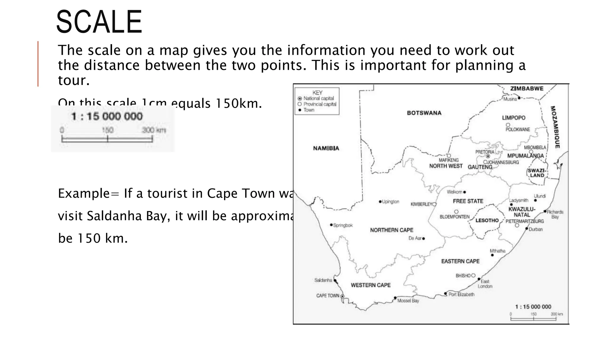
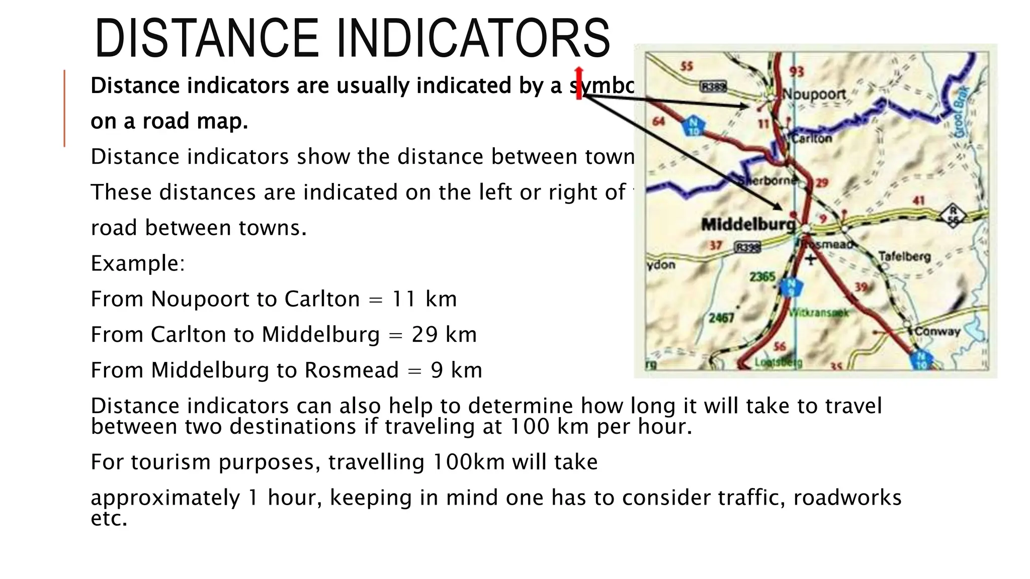
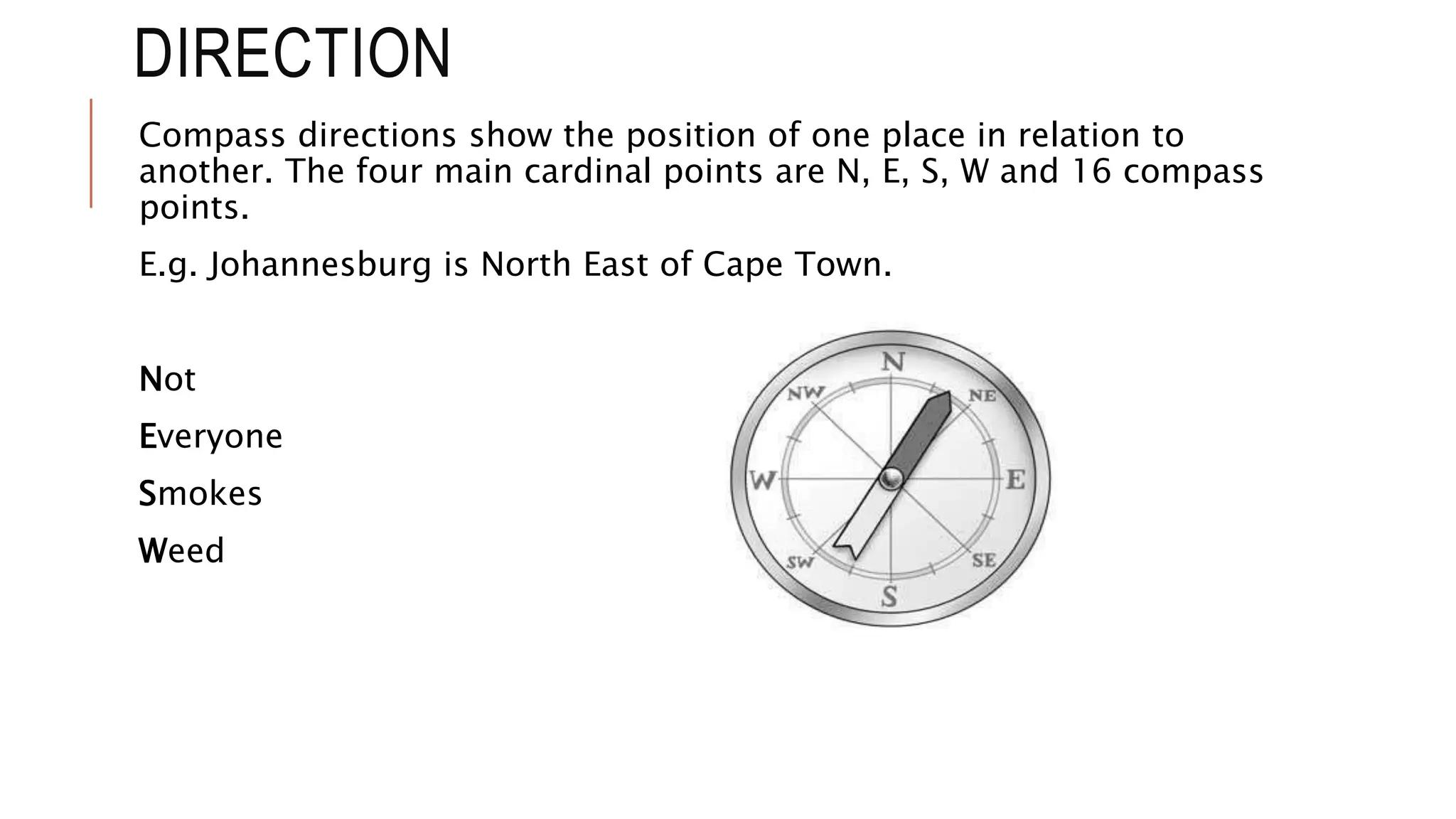
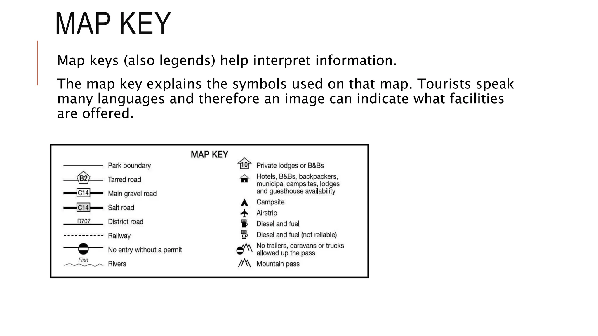
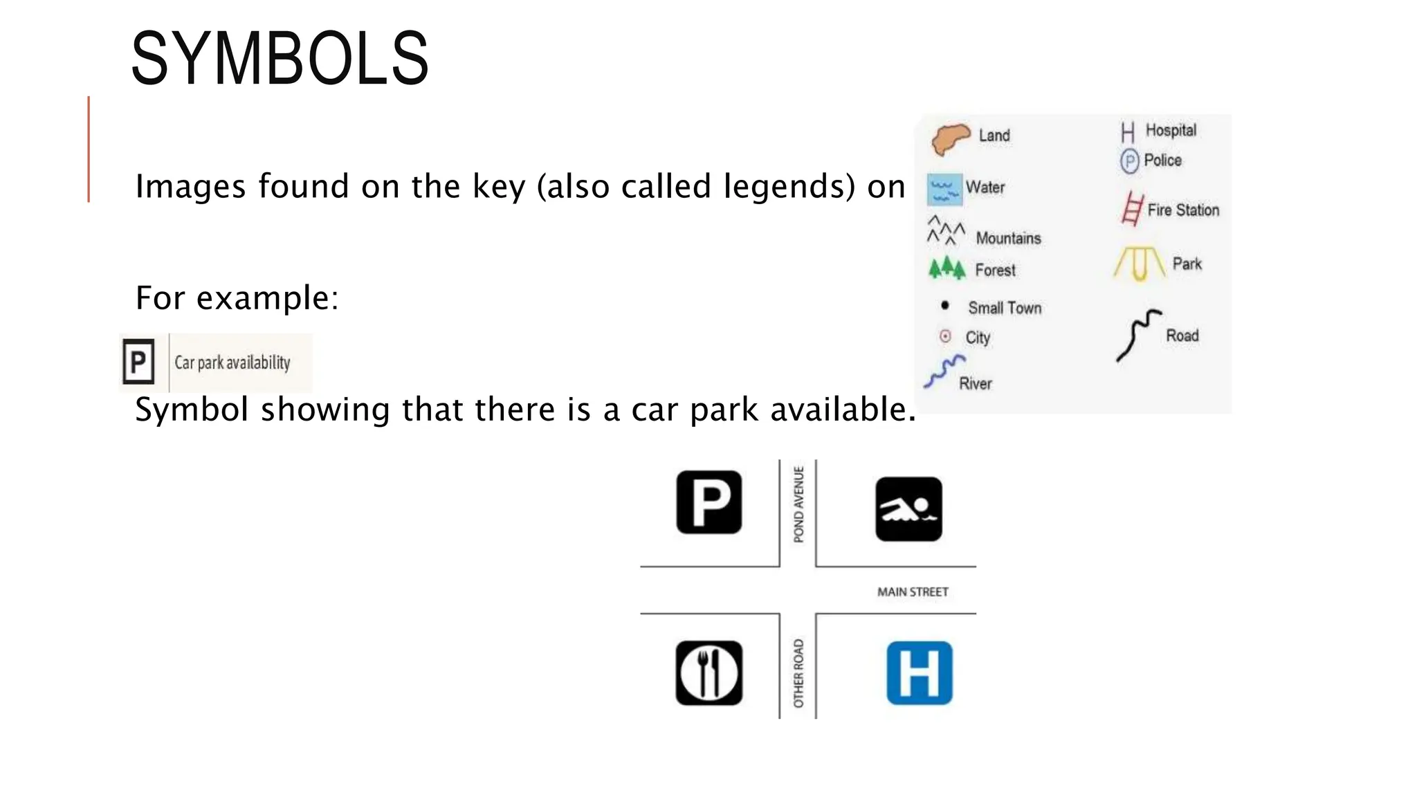
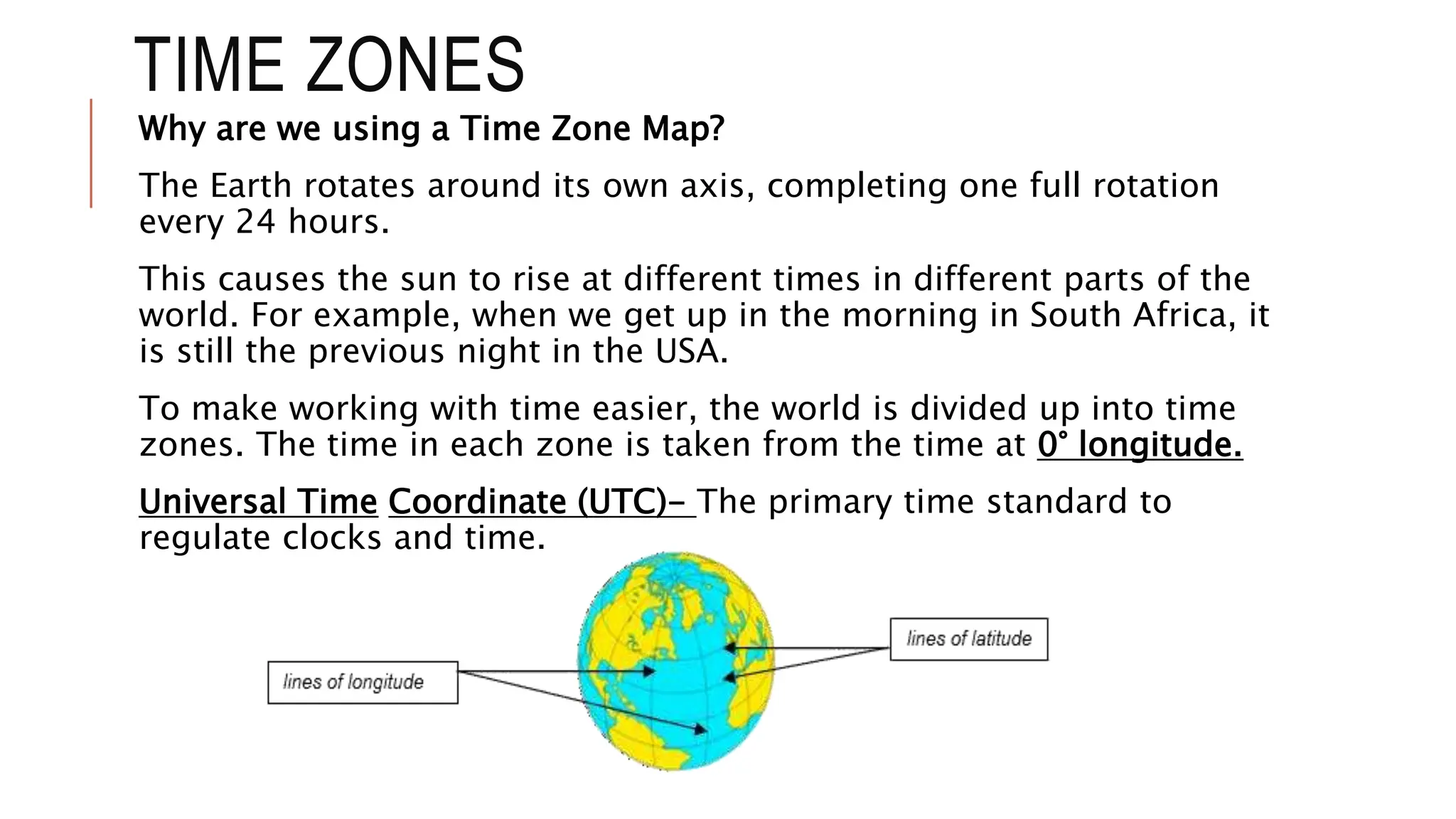
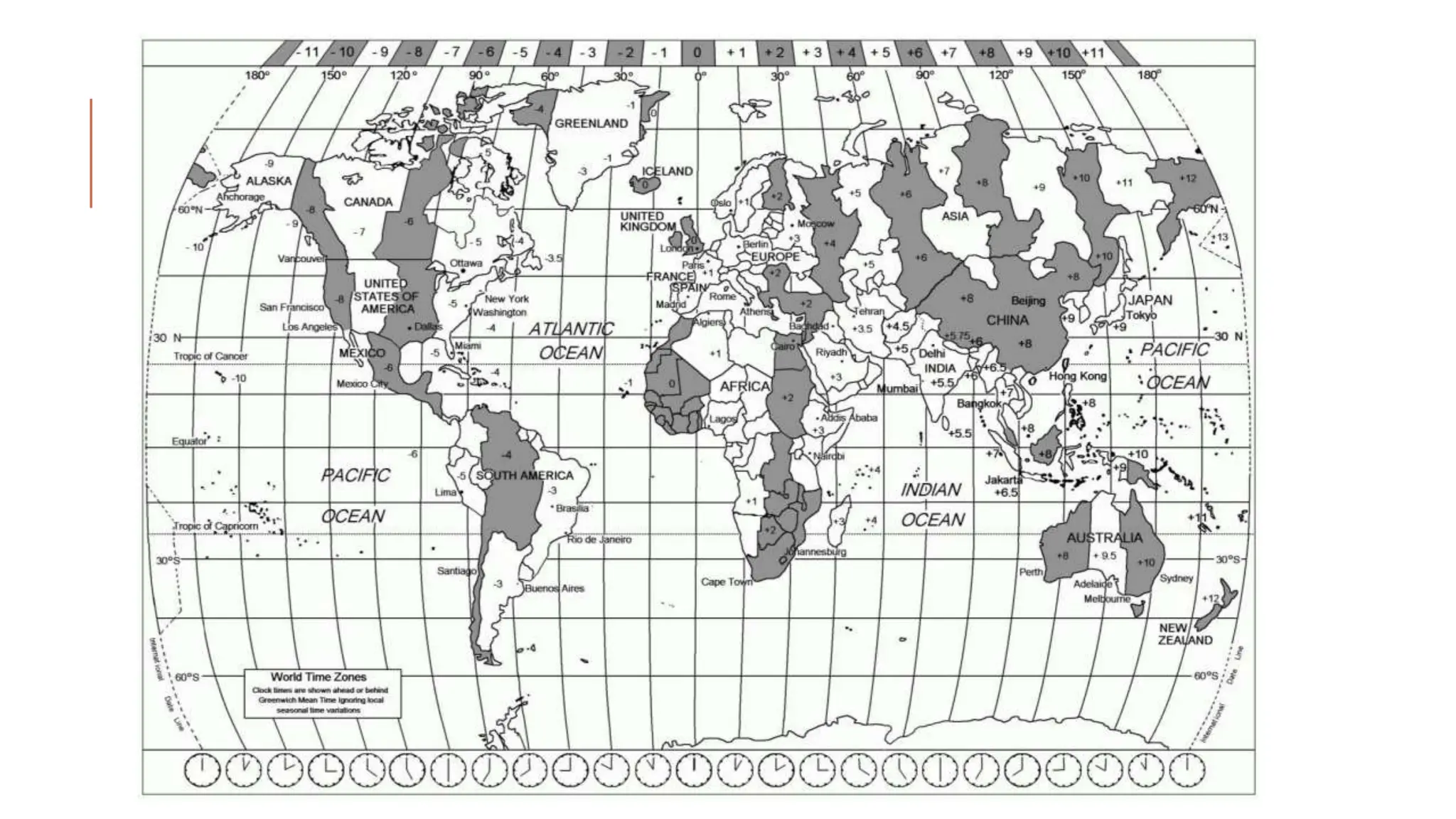
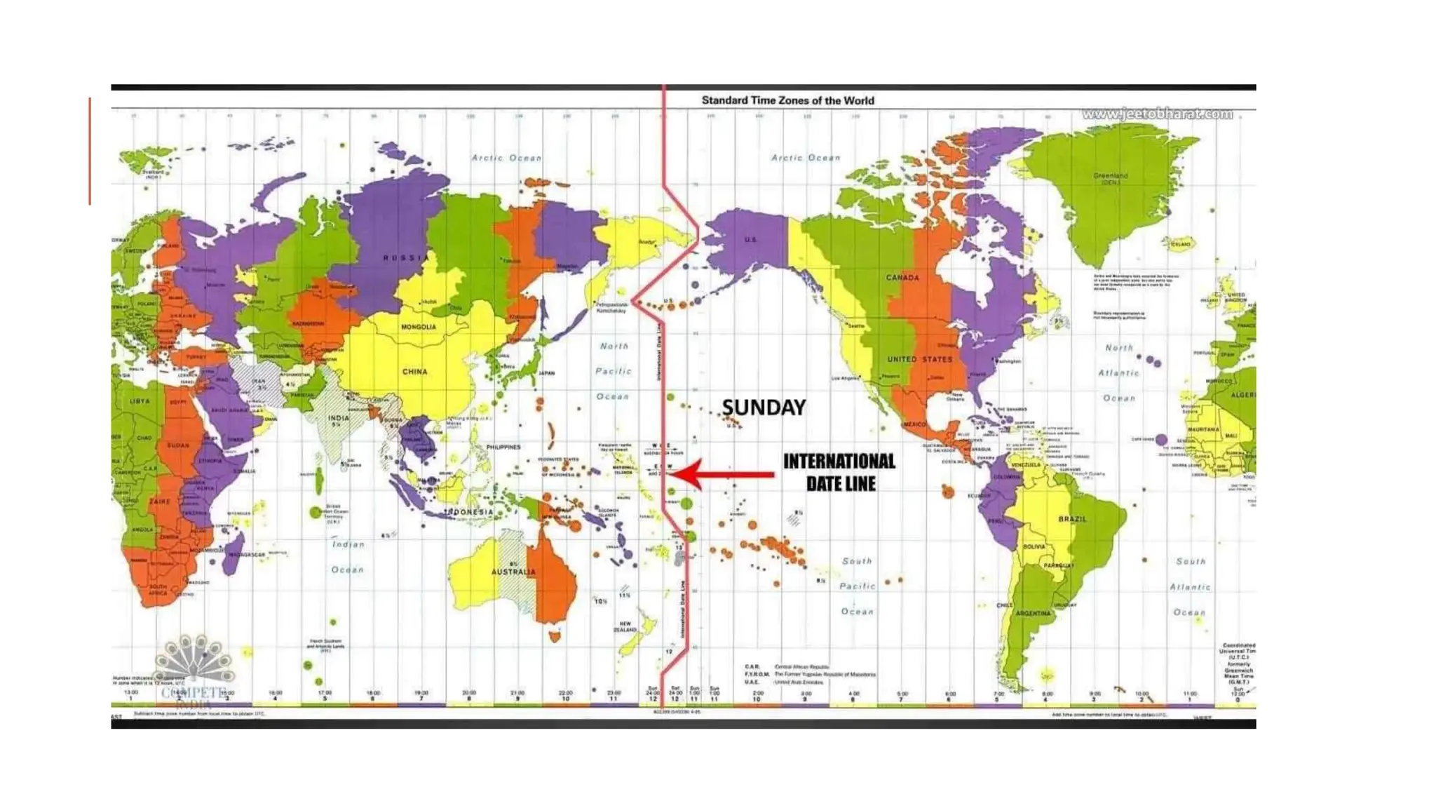
MAP TERMINOLOGY AND
MAP SYMBOLS
TERM 2 !!!!!
SCALE
The scale on a map gives you the information you need to work out
the distance between the two points. This is important for planning a
tour.
On this scale 1cm equals 150km.
Example= If a tourist in Cape Town want to
visit Saldanha Bay, it will be approximately
be 150 km.
Distance indicators are usually indicated by a symbol
on a road map.
Distance indicators show the distance between towns.
These distances are indicated on the left or right of the
road between towns.
Example:
From Noupoort to Carlton = 11 km
From Carlton to Middelburg = 29 km
From Middelburg to Rosmead = 9 km
Distance indicators can also help to determine how long it will take to travel
between two destinations if traveling at 100 km per hour.
For tourism purposes, travelling 100km will take
approximately 1 hour, keeping in mind one has to consider traffic, roadworks
etc.
DISTANCE INDICATORS
DIRECTION
Compass directions show the position of one place in relation to
another. The four main cardinal points are N, E, S, W and 16 compass
points.
E.g. Johannesburg is North East of Cape Town.
Not
Everyone
Smokes
Weed
MAP KEY
Map keys (also legends) help interpret information.
The map key explains the symbols used on that map. Tourists speak
many languages and therefore an image can indicate what facilities
are offered.
SYMBOLS
Images found on the key (also called legends) on the map.
For example:
Symbol showing that there is a car park available.
TIME ZONES
Why are we using a Time Zone Map?
The Earth rotates around its own axis, completing one full rotation
every 24 hours.
This causes the sun to rise at different times in different parts of the
world. For example, when we get up in the morning in South Africa, it
is still the previous night in the USA.
To make working with time easier, the world is divided up into time
zones. The time in each zone is taken from the time at 0° longitude.
Universal Time Coordinate (UTC)- The primary time standard to
regulate clocks and time.
Countries, such as Australia and Canada, have more than one time
zone because they stretch over many zones from west to east. There
is a one-hour difference between each time zone.
The 180° line is called the International Date Line (IDL) that separates
two consecutive calendar days.
The date in the Eastern hemisphere, to the left of the line, is always
one day ahead of the date in the Western hemisphere.
The reason the IDL zigzag is to avoid confusion by splitting a
town/country into two separate days. Countries along the IDL
determine which side of the IDL they want to follow.
DIFFERENT TYPES OF MAPS
Road maps
* Indicate the roads that connect
towns and cities.
* The distance between towns
and cities are useful for working
out travelling time to
destinations.
Street maps
* Show the layout of roads and
streets in towns/ cities.
* Show places tourists may need.
(hospitals, hotels, shops)
* Tourists brochures, websites,
other advertisements for
accommodation + attractions
provide small street map to find
easily.
Political maps
* Show the borders of countries,
states and provinces.
* Help tourists who plan to travel
across borders/ provinces,
indicate where the destinations
are located.
Physical maps
* Show natural and man made
features in a area.
* Mountains, rivers, deserts,
rivers, ocean.
* Colour is used to show the
heights of different land areas.
* Helps adventure tourists.
Specialist maps
* Show specific information such
as climate or the location of
airports/ train routes.
* Weather maps used to show
weather predictions for following
few days. Newspapers publish
this, also end of news at night.
Tourists information maps
* Provide information about
attractions, where to go, stop
and expect in an area.
* Tourist places are normally
indicated on brown signage
boards.
National parks
* Tourist information maps.
* Show distances, camp sites,
attractions and routes.
* Provides tourists information
about how long it will take them
to get from one place to the
next.
Electronic maps
* Most popular internet source of
electronic maps is Google.
* You can few maps and satellite images on
Google earth. Even local street maps and
view houses.
Global Positioning Systems (GPS)
* Receives data from satellites and uses the
data to generate maps showing latitude,
longitude and altitude.
* A destination is keyed in as a address or
as co- ordinates.
* Co- ordinates can be given in degrees,
minutes and seconds/ decimal format.
* Specific destinations names can be keyed
in.
* Smart phones have a built – in GPS
system.
Google earth
* Satellite pictures of any place
on earth in 3D
* Google street view: An
application of Google Earth
* Can rotate the view from
different angles.
* Offer street maps and route
planners, used to locate specific
destinations.
Information Communication
Technology (ICT) in Tourism
Communication devices- radio,
TV, cell phones, computers,
satellite systems:
* Internet – Provides up to date
information, tourists can plan
their holidays in advance
* Interactive maps- Can be
located on travel related
websites.

Tourism -Map terminology and map symbols.pptx

  • 1.
    MAP TERMINOLOGY AND MAPSYMBOLS TERM 2 !!!!!
  • 2.
    SCALE The scale ona map gives you the information you need to work out the distance between the two points. This is important for planning a tour. On this scale 1cm equals 150km. Example= If a tourist in Cape Town want to visit Saldanha Bay, it will be approximately be 150 km.
  • 3.
    Distance indicators areusually indicated by a symbol on a road map. Distance indicators show the distance between towns. These distances are indicated on the left or right of the road between towns. Example: From Noupoort to Carlton = 11 km From Carlton to Middelburg = 29 km From Middelburg to Rosmead = 9 km Distance indicators can also help to determine how long it will take to travel between two destinations if traveling at 100 km per hour. For tourism purposes, travelling 100km will take approximately 1 hour, keeping in mind one has to consider traffic, roadworks etc. DISTANCE INDICATORS
  • 4.
    DIRECTION Compass directions showthe position of one place in relation to another. The four main cardinal points are N, E, S, W and 16 compass points. E.g. Johannesburg is North East of Cape Town. Not Everyone Smokes Weed
  • 5.
    MAP KEY Map keys(also legends) help interpret information. The map key explains the symbols used on that map. Tourists speak many languages and therefore an image can indicate what facilities are offered.
  • 6.
    SYMBOLS Images found onthe key (also called legends) on the map. For example: Symbol showing that there is a car park available.
  • 7.
    TIME ZONES Why arewe using a Time Zone Map? The Earth rotates around its own axis, completing one full rotation every 24 hours. This causes the sun to rise at different times in different parts of the world. For example, when we get up in the morning in South Africa, it is still the previous night in the USA. To make working with time easier, the world is divided up into time zones. The time in each zone is taken from the time at 0° longitude. Universal Time Coordinate (UTC)- The primary time standard to regulate clocks and time.
  • 9.
    Countries, such asAustralia and Canada, have more than one time zone because they stretch over many zones from west to east. There is a one-hour difference between each time zone. The 180° line is called the International Date Line (IDL) that separates two consecutive calendar days. The date in the Eastern hemisphere, to the left of the line, is always one day ahead of the date in the Western hemisphere. The reason the IDL zigzag is to avoid confusion by splitting a town/country into two separate days. Countries along the IDL determine which side of the IDL they want to follow.
  • 11.
    DIFFERENT TYPES OFMAPS Road maps * Indicate the roads that connect towns and cities. * The distance between towns and cities are useful for working out travelling time to destinations. Street maps * Show the layout of roads and streets in towns/ cities. * Show places tourists may need. (hospitals, hotels, shops) * Tourists brochures, websites, other advertisements for accommodation + attractions provide small street map to find easily.
  • 12.
    Political maps * Showthe borders of countries, states and provinces. * Help tourists who plan to travel across borders/ provinces, indicate where the destinations are located. Physical maps * Show natural and man made features in a area. * Mountains, rivers, deserts, rivers, ocean. * Colour is used to show the heights of different land areas. * Helps adventure tourists.
  • 13.
    Specialist maps * Showspecific information such as climate or the location of airports/ train routes. * Weather maps used to show weather predictions for following few days. Newspapers publish this, also end of news at night. Tourists information maps * Provide information about attractions, where to go, stop and expect in an area. * Tourist places are normally indicated on brown signage boards.
  • 14.
    National parks * Touristinformation maps. * Show distances, camp sites, attractions and routes. * Provides tourists information about how long it will take them to get from one place to the next. Electronic maps * Most popular internet source of electronic maps is Google. * You can few maps and satellite images on Google earth. Even local street maps and view houses. Global Positioning Systems (GPS) * Receives data from satellites and uses the data to generate maps showing latitude, longitude and altitude. * A destination is keyed in as a address or as co- ordinates. * Co- ordinates can be given in degrees, minutes and seconds/ decimal format. * Specific destinations names can be keyed in. * Smart phones have a built – in GPS system.
  • 15.
    Google earth * Satellitepictures of any place on earth in 3D * Google street view: An application of Google Earth * Can rotate the view from different angles. * Offer street maps and route planners, used to locate specific destinations. Information Communication Technology (ICT) in Tourism Communication devices- radio, TV, cell phones, computers, satellite systems: * Internet – Provides up to date information, tourists can plan their holidays in advance * Interactive maps- Can be located on travel related websites.