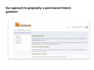
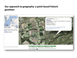
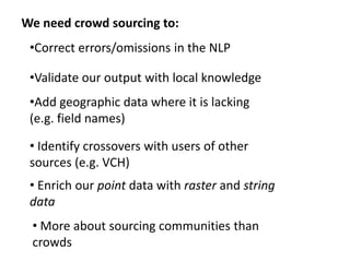
The Digital Exposure of English
         Place-names
             Stuart Dunn
    Department of Digital Humanities
        Kings College London

            7th March 2012

http://englishplacenames.cerch.kcl.ac.uk
Place names

• Dynamic

• Attested

•Contested

• Documented and...
...Researched


Photos courtesy of Jo Walsh
DEEP in numbers
• 80 years of scholarship

• 32 English counties

• 86 volumes

• 6157 elements

• 30,517 pages

• c 4,000,000 individual place-name forms

• ??? Bibliographic references (we will know soon – it’s quite a lot)
Contested
interpretations and
etymologies
Dates/references
Previous work: CHALICE pilot
Current work (in progress)
Our approach to geography: a point-based historic
gazetteer
Our approach to geography: a point-based historic
gazetteer
Points, lines and polygons are problematic!

•Pre-OS there is very little data on geographic
associations of place-names
(http://chalice.blogs.edina.ac.uk/files/2011/06/VCH_FI
NAL1.pdf)                                              Hadrian’s Wall

                                                Roman
•Points are arbitrary                           bridgehead
dependent on scale
                        Modern
• Administrative        course of R.
                        Irthing
geographies change over
time


 • Even natural features
 can mislead
We need crowd sourcing to:
 •Correct errors/omissions in the NLP

 •Validate our output with local knowledge
 •Add geographic data where it is lacking
 (e.g. field names)

 • Identify crossovers with users of other
 sources (e.g. VCH)
 • Enrich our point data with raster and string
 data
 • More about sourcing communities than
 crowds
New project!
  • AHRC-funded scoping study under Connected
  Communities
 • Feb-November 2012

  • Research crowd-sourcing models for the
  humanities

  • 2 expert seminars

  • Develop a typology of crowd-sourcing methods

  • Report/roadmap


stuart.dunn@kcl.ac.uk                    mark.hedges@kcl.ac.uk

Digital Exposure of English Place-Names (DEEP) -Stuart Dunn

  • 1.
    The Digital Exposureof English Place-names Stuart Dunn Department of Digital Humanities Kings College London 7th March 2012 http://englishplacenames.cerch.kcl.ac.uk
  • 2.
    Place names • Dynamic •Attested •Contested • Documented and...
  • 3.
  • 4.
    DEEP in numbers •80 years of scholarship • 32 English counties • 86 volumes • 6157 elements • 30,517 pages • c 4,000,000 individual place-name forms • ??? Bibliographic references (we will know soon – it’s quite a lot)
  • 5.
  • 6.
  • 7.
  • 8.
  • 9.
    Our approach togeography: a point-based historic gazetteer
  • 10.
    Our approach togeography: a point-based historic gazetteer
  • 11.
    Points, lines andpolygons are problematic! •Pre-OS there is very little data on geographic associations of place-names (http://chalice.blogs.edina.ac.uk/files/2011/06/VCH_FI NAL1.pdf) Hadrian’s Wall Roman •Points are arbitrary bridgehead dependent on scale Modern • Administrative course of R. Irthing geographies change over time • Even natural features can mislead
  • 13.
    We need crowdsourcing to: •Correct errors/omissions in the NLP •Validate our output with local knowledge •Add geographic data where it is lacking (e.g. field names) • Identify crossovers with users of other sources (e.g. VCH) • Enrich our point data with raster and string data • More about sourcing communities than crowds
  • 14.
    New project! • AHRC-funded scoping study under Connected Communities • Feb-November 2012 • Research crowd-sourcing models for the humanities • 2 expert seminars • Develop a typology of crowd-sourcing methods • Report/roadmap stuart.dunn@kcl.ac.uk mark.hedges@kcl.ac.uk