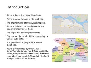
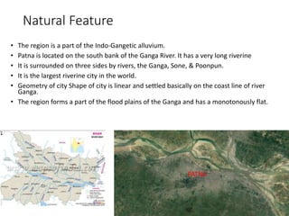
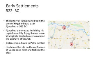
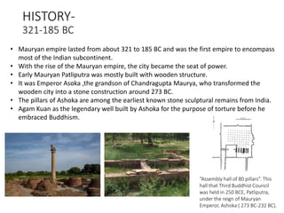
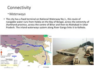
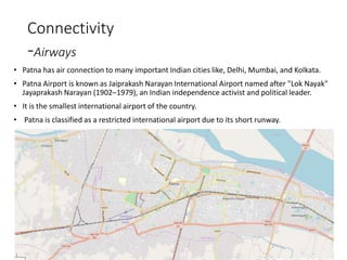
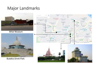
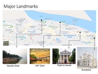
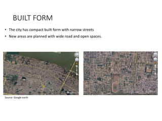
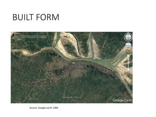
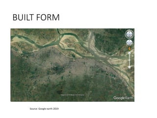
STRUCTURE PLAN
PATNA
NISHA RANJAN
Introduction
• Patna is the capital city of Bihar State.
• Patna is one of the oldest cities in India.
• The original name of Patna was Patliputra.
• Patna is an important administrative and
educational center for Bihar.
• The region has a subtropical climate.
• City has population of 16.8 lakh according to
Census 2011 data.
• It is spread over a geographical area of
3,202 km².
• Patna is surrounded by the districts
Saran,Vaishaly, Samastipur & Begusarai in the
North, Bhojpur district in the West, districts of
Jehanabad, Lakhisarai, & Nalanda in the South
& Begusarai district in the East.
Natural Feature
• The region is a part of the Indo-Gangetic alluvium.
• Patna is located on the south bank of the Ganga River. It has a very long riverine
• It is surrounded on three sides by rivers, the Ganga, Sone, & Poonpun.
• It is the largest riverine city in the world.
• Geometry of city Shape of city is linear and settled basically on the coast line of river
Ganga.
• The region forms a part of the flood plains of the Ganga and has a monotonously flat.
PATNA
Early Settlements
522- BC
A
B
• The history of Patna started from the
time of King Bimbisara’s son
Ajatashatru (522 BC).
• Ajatashatru interested in shifting his
capital from hilly Rajagriha to a more
strategically located place to compact
the Licchavis of Vaishali.
• Distance from Rajgir to Patna is 70km
• He choose the site on the confluence
of Ganga-sone River and fortified the
area.
HISTORY-
321-185 BC
• Mauryan empire lasted from about 321 to 185 BC and was the first empire to encompass
most of the Indian subcontinent.
• With the rise of the Mauryan empire, the city became the seat of power.
• Early Mauryan Patliputra was mostly built with wooden structure.
• It was Emperor Asoka ,the grandson of Chandragupta Maurya, who transformed the
wooden city into a stone construction around 273 BC.
• The pillars of Ashoka are among the earliest known stone sculptural remains from India.
• Agam Kuan as the legendary well built by Ashoka for the purpose of torture before he
embraced Buddhism.
“Assembly hall of 80 pillars”. This
hall that Third Buddhist Council
was held in 250 BCE, Patliputra,
under the reign of Mauryan
Emperor, Ashoka ( 273 BC-232 BC).
185BC-16th Century
• In 185 BC with the foundation of the Sunga Dynasty in Magadha. It saw the rules of the
Gupta empire and the Pala kings.
• Bakhtiar Khilji captured Bihar in 1197 AD and destroyed many ancient seats of learning.
• In 1288 AD Bihar became a part of Delhi kingdom.
• The most remarkable period was the middle of the 16 th century, during these times, Patna
was revived under Sher Shah Suri.
• He constructed a fort and a town on the banks of Ganga and the mosque built in Afghan
architectural.
• It was August 1574 when Akbar came to Patna to crush The Afghan Chief, Daud
Khan.
• Akbar’s navratna and secretary of state, historian and author of Ain-i-Akbari
refers to Patna as a flourishing centre for stone, paper and glass industries.
• He also quoted to the high quality of numerous varieties of rice grown in Patna
that had gained popularity in Europe.
• Mughal Emperor Aurangzeb agreed to the request of his favorite grandson,
Prince Muhammad Azim to rename Patna as Azimabad in 1704 AD while Azim
was in Patna as a Subedar.
• With decline of Mughal power, Patna goes into the hands of the Nawabs of
Bengal, who maintained its commercial prosperity.
The great Choke,' both sides of the main street of Patna, dominated by
two facing chattris; a watercolor by Seeta Ram, 1814-15
On the Map of Patna is shown the three phases of development of the city.
The City Development During British Rule in 3Phases.
1- Along The River Front
2-On The Southern Side Of Gandhi Maidan To Railway Station
3-The New Capital Area. A-Fort Area.
• During the 17th century Patna became the centre of international
trade.
• In year 1620, the British started with a factory in Patna for the
trading in calico and silk.
17th Century
• The city limits were stretched westwards to accommodate the administrative
base, and the township of Bankipore took shape along the Bailey
• The Patna Secretariat with its imposing clock tower and the Patna High Court are
two imposing landmarks of this era of development.
• The Museum was constructed by the British to conserve and display the historical
artifacts found in the vicinity of the state capital.
17th Century
• The British built several educational institutions in Patna like Patna College, Patna
Science College, Bihar College of Engineering, Prince of Wales Medical
College(Patna Medical College and Hospital ) and the Patna Veterinary College.
17th Century
Source- tourisminbihar.com
Source- Dainik Bhaskar
Patna High Court
Patna Secretariat
Patna Museum
Source- tourisminbihar.com Patna Medical College and Hospital
• It is the Gola, a granary built by the british in 1786 as a precaution against famine.
• Built in the Stupa architecture
18th Century
Source- tourisminbihar.com
A watercolour by Robert Smith , 1814-1815
• Most notable are the Champaran movement against the Indigo plantation
and the Quit India Movement of 1942.
• On 1 April,1912, when Bengal Presidency was partitioned, Patna became
the capital of Bihar and Orissa Province.
• It soon emerged as an important and strategic centre.
• On 1 April, 1936, Orissa was carved out as a separate province in the
British Indian Empire. Patna continued as the capital of Bihar province.
• Patna hosted the first ever woman's Kabaddi world cup. It was held at
the Patliputra Sports Complex, Kankarbagh
Major Events
Patliputra Sports Complex
Connectivity
-Railways
• In 1862 Patna junction was constructed by the British.
• The Patna Junction railway station is the main railway station
of the city, and one of the busiest railway stations in India.
• There are three railway lines running across the district.
• The city has four additional major railway stations
i. Rajendra Nagar Terminal
ii. Patliputra Junction
iii. Danapur
iv. Patna Sahib
Connectivity
-Roadways
• The bridge over the river Ganges named Mahatma Gandhi Setu is 5575m long connecting Patna in the
south to Hajipur in the north of Bihar.
• It is the third-longest river bridge in India.It was inaugurated in May 1982.
• Digha–Sonpur rail–road is a bridge across river Ganga, connecting Digha Ghat in Patna and Pahleja Ghat
in Sonpur.
• Ashok Raj Path and including its extended part as Danapur road and NH-30 constitutes the longest road
in Patna serving as major arterial roads.
• Patna is served by National Highways which are NH30, 31, 98 and 83.
• NH- 83 and 30 are entirely within the state and forms the regional connectivity of the area.
• NH-31 is important as it acts as a gateway to the states in northeast India.
Digha–Sonpur Bridge Mahatma Gandhi Setu bridge and pontoon bridge NH Route Map
Connectivity
-Waterways
• The city has a fixed terminal on National Waterway No.1., this route of
navigable water runs from Haldia on the Bay of Bengal, across the extremity of
Jharkhand province, across the centre of Bihar and then to Allahabad in Uttar
Pradesh. The inland waterways system along River Ganga links it to Kolkata.
Connectivity
-Airways
• Patna has air connection to many important Indian cities like, Delhi, Mumbai, and Kolkata.
• Patna Airport is known as Jaiprakash Narayan International Airport named after "Lok Nayak"
Jayaprakash Narayan (1902–1979), an Indian independence activist and political leader.
• It is the smallest international airport of the country.
• Patna is classified as a restricted international airport due to its short runway.
Major Landmarks
Buddha Smriti Park
Bihar Museum
Major Landmarks
Gandhi Ghat NIT Ghat Padri ki Haveli
Gurdwara
BUILT FORM
• The city has compact built form with narrow streets
• New areas are planned with wide road and open spaces.
Source- Google earth
BUILT FORM
Source- Google earth-1984
•
BUILT FORM
Source- Google earth-2019
•

Structure plan

  • 1.
  • 2.
    Introduction • Patna isthe capital city of Bihar State. • Patna is one of the oldest cities in India. • The original name of Patna was Patliputra. • Patna is an important administrative and educational center for Bihar. • The region has a subtropical climate. • City has population of 16.8 lakh according to Census 2011 data. • It is spread over a geographical area of 3,202 km². • Patna is surrounded by the districts Saran,Vaishaly, Samastipur & Begusarai in the North, Bhojpur district in the West, districts of Jehanabad, Lakhisarai, & Nalanda in the South & Begusarai district in the East.
  • 3.
    Natural Feature • Theregion is a part of the Indo-Gangetic alluvium. • Patna is located on the south bank of the Ganga River. It has a very long riverine • It is surrounded on three sides by rivers, the Ganga, Sone, & Poonpun. • It is the largest riverine city in the world. • Geometry of city Shape of city is linear and settled basically on the coast line of river Ganga. • The region forms a part of the flood plains of the Ganga and has a monotonously flat. PATNA
  • 4.
    Early Settlements 522- BC A B •The history of Patna started from the time of King Bimbisara’s son Ajatashatru (522 BC). • Ajatashatru interested in shifting his capital from hilly Rajagriha to a more strategically located place to compact the Licchavis of Vaishali. • Distance from Rajgir to Patna is 70km • He choose the site on the confluence of Ganga-sone River and fortified the area.
  • 5.
    HISTORY- 321-185 BC • Mauryanempire lasted from about 321 to 185 BC and was the first empire to encompass most of the Indian subcontinent. • With the rise of the Mauryan empire, the city became the seat of power. • Early Mauryan Patliputra was mostly built with wooden structure. • It was Emperor Asoka ,the grandson of Chandragupta Maurya, who transformed the wooden city into a stone construction around 273 BC. • The pillars of Ashoka are among the earliest known stone sculptural remains from India. • Agam Kuan as the legendary well built by Ashoka for the purpose of torture before he embraced Buddhism. “Assembly hall of 80 pillars”. This hall that Third Buddhist Council was held in 250 BCE, Patliputra, under the reign of Mauryan Emperor, Ashoka ( 273 BC-232 BC).
  • 6.
    185BC-16th Century • In185 BC with the foundation of the Sunga Dynasty in Magadha. It saw the rules of the Gupta empire and the Pala kings. • Bakhtiar Khilji captured Bihar in 1197 AD and destroyed many ancient seats of learning. • In 1288 AD Bihar became a part of Delhi kingdom. • The most remarkable period was the middle of the 16 th century, during these times, Patna was revived under Sher Shah Suri. • He constructed a fort and a town on the banks of Ganga and the mosque built in Afghan architectural.
  • 7.
    • It wasAugust 1574 when Akbar came to Patna to crush The Afghan Chief, Daud Khan. • Akbar’s navratna and secretary of state, historian and author of Ain-i-Akbari refers to Patna as a flourishing centre for stone, paper and glass industries. • He also quoted to the high quality of numerous varieties of rice grown in Patna that had gained popularity in Europe. • Mughal Emperor Aurangzeb agreed to the request of his favorite grandson, Prince Muhammad Azim to rename Patna as Azimabad in 1704 AD while Azim was in Patna as a Subedar. • With decline of Mughal power, Patna goes into the hands of the Nawabs of Bengal, who maintained its commercial prosperity. The great Choke,' both sides of the main street of Patna, dominated by two facing chattris; a watercolor by Seeta Ram, 1814-15
  • 8.
    On the Mapof Patna is shown the three phases of development of the city. The City Development During British Rule in 3Phases. 1- Along The River Front 2-On The Southern Side Of Gandhi Maidan To Railway Station 3-The New Capital Area. A-Fort Area. • During the 17th century Patna became the centre of international trade. • In year 1620, the British started with a factory in Patna for the trading in calico and silk. 17th Century
  • 9.
    • The citylimits were stretched westwards to accommodate the administrative base, and the township of Bankipore took shape along the Bailey • The Patna Secretariat with its imposing clock tower and the Patna High Court are two imposing landmarks of this era of development. • The Museum was constructed by the British to conserve and display the historical artifacts found in the vicinity of the state capital. 17th Century
  • 10.
    • The Britishbuilt several educational institutions in Patna like Patna College, Patna Science College, Bihar College of Engineering, Prince of Wales Medical College(Patna Medical College and Hospital ) and the Patna Veterinary College. 17th Century Source- tourisminbihar.com Source- Dainik Bhaskar Patna High Court Patna Secretariat Patna Museum Source- tourisminbihar.com Patna Medical College and Hospital
  • 11.
    • It isthe Gola, a granary built by the british in 1786 as a precaution against famine. • Built in the Stupa architecture 18th Century Source- tourisminbihar.com A watercolour by Robert Smith , 1814-1815
  • 12.
    • Most notableare the Champaran movement against the Indigo plantation and the Quit India Movement of 1942. • On 1 April,1912, when Bengal Presidency was partitioned, Patna became the capital of Bihar and Orissa Province. • It soon emerged as an important and strategic centre. • On 1 April, 1936, Orissa was carved out as a separate province in the British Indian Empire. Patna continued as the capital of Bihar province. • Patna hosted the first ever woman's Kabaddi world cup. It was held at the Patliputra Sports Complex, Kankarbagh Major Events Patliputra Sports Complex
  • 13.
    Connectivity -Railways • In 1862Patna junction was constructed by the British. • The Patna Junction railway station is the main railway station of the city, and one of the busiest railway stations in India. • There are three railway lines running across the district. • The city has four additional major railway stations i. Rajendra Nagar Terminal ii. Patliputra Junction iii. Danapur iv. Patna Sahib
  • 14.
    Connectivity -Roadways • The bridgeover the river Ganges named Mahatma Gandhi Setu is 5575m long connecting Patna in the south to Hajipur in the north of Bihar. • It is the third-longest river bridge in India.It was inaugurated in May 1982. • Digha–Sonpur rail–road is a bridge across river Ganga, connecting Digha Ghat in Patna and Pahleja Ghat in Sonpur. • Ashok Raj Path and including its extended part as Danapur road and NH-30 constitutes the longest road in Patna serving as major arterial roads. • Patna is served by National Highways which are NH30, 31, 98 and 83. • NH- 83 and 30 are entirely within the state and forms the regional connectivity of the area. • NH-31 is important as it acts as a gateway to the states in northeast India. Digha–Sonpur Bridge Mahatma Gandhi Setu bridge and pontoon bridge NH Route Map
  • 15.
    Connectivity -Waterways • The cityhas a fixed terminal on National Waterway No.1., this route of navigable water runs from Haldia on the Bay of Bengal, across the extremity of Jharkhand province, across the centre of Bihar and then to Allahabad in Uttar Pradesh. The inland waterways system along River Ganga links it to Kolkata.
  • 16.
    Connectivity -Airways • Patna hasair connection to many important Indian cities like, Delhi, Mumbai, and Kolkata. • Patna Airport is known as Jaiprakash Narayan International Airport named after "Lok Nayak" Jayaprakash Narayan (1902–1979), an Indian independence activist and political leader. • It is the smallest international airport of the country. • Patna is classified as a restricted international airport due to its short runway.
  • 17.
  • 18.
    Major Landmarks Gandhi GhatNIT Ghat Padri ki Haveli Gurdwara
  • 19.
    BUILT FORM • Thecity has compact built form with narrow streets • New areas are planned with wide road and open spaces. Source- Google earth
  • 20.
  • 21.