
Recommended
More Related Content
What's hot
What's hot (20)
Similar to Std 4 Ch1 Our World
Similar to Std 4 Ch1 Our World (20)
Recently uploaded
Recently uploaded (20)
Std 4 Ch1 Our World
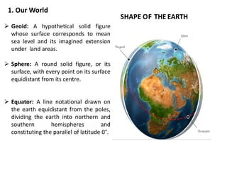
- 1. SHAPE OF THE EARTH Geoid: A hypothetical solid figure whose surface corresponds to mean sea level and its imagined extension under land areas. Sphere: A round solid figure, or its surface, with every point on its surface equidistant from its centre. Equator: A line notational drawn on the earth equidistant from the poles, dividing the earth into northern and southern hemispheres and constituting the parallel of latitude 0°. 1. Our World
- 2. GLOBES AND MAPS GLOBES : A globe is three-dimensional model of the earth. As the earth is so large, we cannot look at it as a whole. The globe represent the earth as it looks from the space. MAPS : A map is a flat and two dimensional drawing of the entire or a particular portion of the earth. It can show only a part of the earth surface in detail at one time. Maps are easier to carry. A person who makes map is called cartographer.
- 4. Continents and Oceans There are seven continents and five oceans in the world. Three parts of the world are covered with water and only one part consists of land. Continents Oceans Asia Pacific Africa Atlantic North America Indian South America Southern Europe Arctic Australia Antarctica
- 5. Continents Continents are continuous expanses of land. Each continent is made up of different countries. for example there are 54 countries in the continent of Africa. ASIA includes 50 countries, and it is the most populated continent, the 60% of the total population of the Earth live here. AFRICA comprises 54 countries. It is the hottest continent and home of the world's largest desert, the Sahara, occupying the 25% of the total area of Africa. NORTH AMERICA includes 23 countries led by the USA as the largest economy in the world.
- 6. SOUTH AMERICA comprises 12 countries. Here is located the largest forest, the Amazon rainforest, which covers 30% of the South America total area. ANTARCTICA is the coldest continent in the world, completely covered with ice. There are no permanent inhabitants, except of scientists maintaining research stations in Antarctica. EUROPE comprises 51 countries. It is the most developed economically continent with the European Union as the biggest economic and political union in the world. AUSTRALIA includes 14 countries. It is the least populated continent after Antarctica, only 0.2% of the total Earth population live here.
- 7. Oceans The large water bodies on the Earth are known as oceans. Oceans and their features are
- 8. LATITUDES AND LONGITUDES Cartographers and geographers trace horizontal and vertical lines called latitudes and longitudes across Earth's surface to locate points on the globe. LATITUDES : The angular distance of a place north or south of the earth's equator, or of the equator of a celestial object, usually expressed in degrees and minutes. For e.g. "at a latitude of 51° N" LONGITUDES: The angular distance of a place east or west of the Greenwich meridian, or west of the standard meridian of a celestial object, usually expressed in degrees and minutes. For E.g. "at a longitude of 2° W"
- 9. Parallels of Latitudes The line that passes horizontally through the middle of the earth is called the Equator. It divides the earth into two equal halves or hemispheres Northern Hemisphere and Southern Hemisphere it is also called 0° latitude. The lines that run parallel to each other and the equator are known as parallels of latitude. The four important parallels of latitude besides the Equator are: Tropic of Cancer at 23 ½° N in the northern hemisphere. Tropic of Capricorn at 23 ½° S in the southern hemisphere. Arctic circle at 66 ½° north of the Equator, and Antarctic circle at 66 ½° South of the Equator.
- 10. Meridians of Longitude Why longitudes are called meridians? Longitudes are known as meridians because in Geographical sense, meridians are great circles which are not parallel to each other but intersect each other at the North and the South Poles. Same stands true of the longitudes. All longitudes are great circles which meet at the Poles.