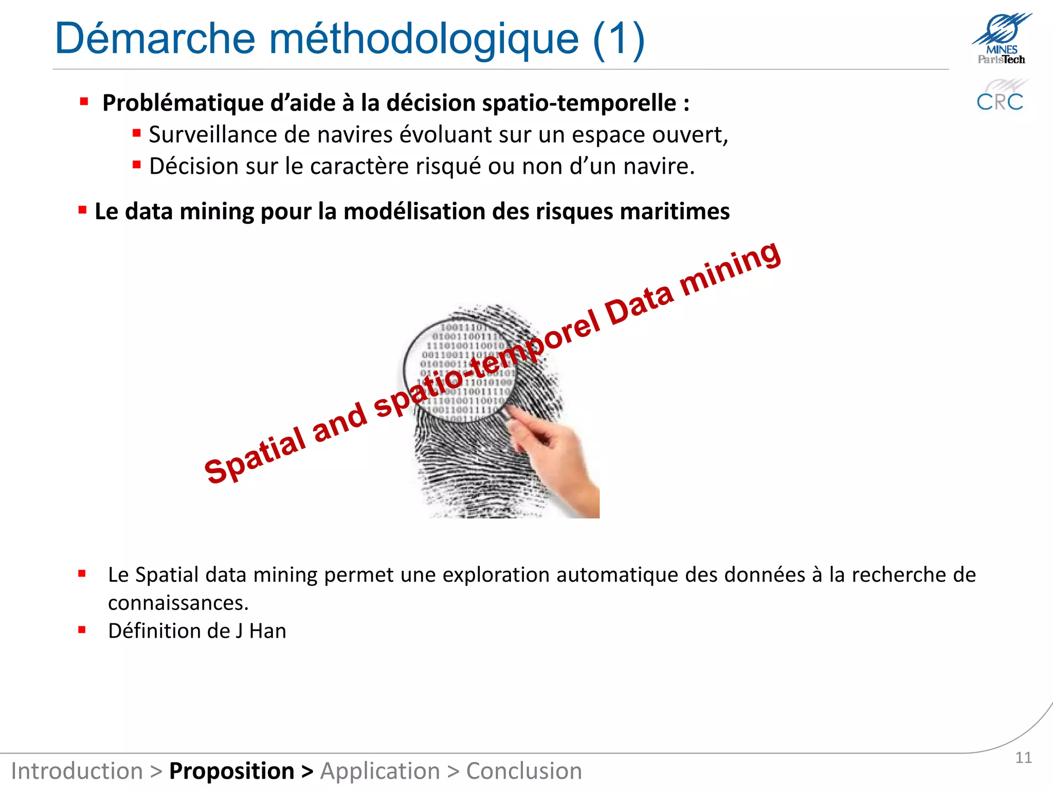
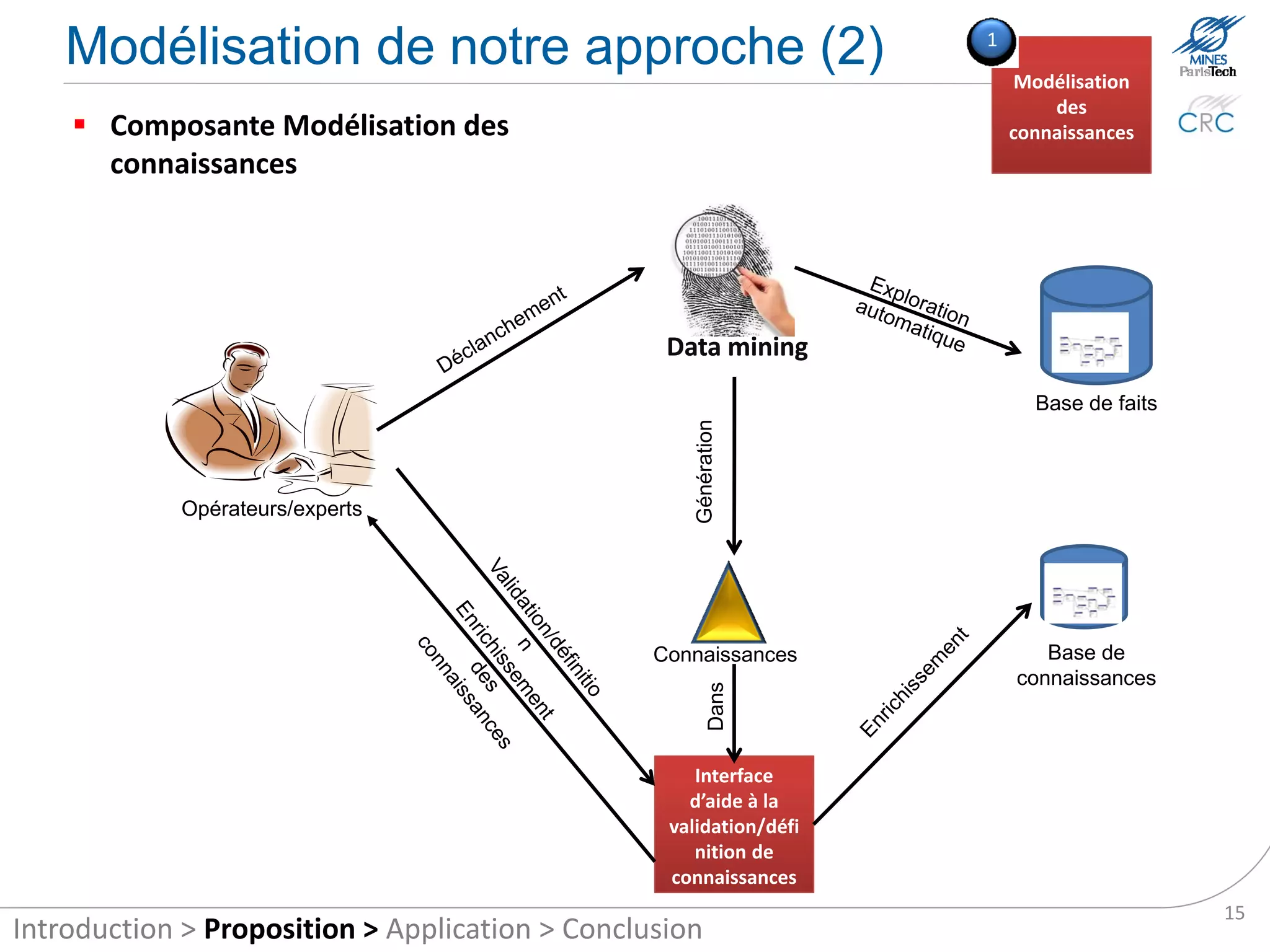
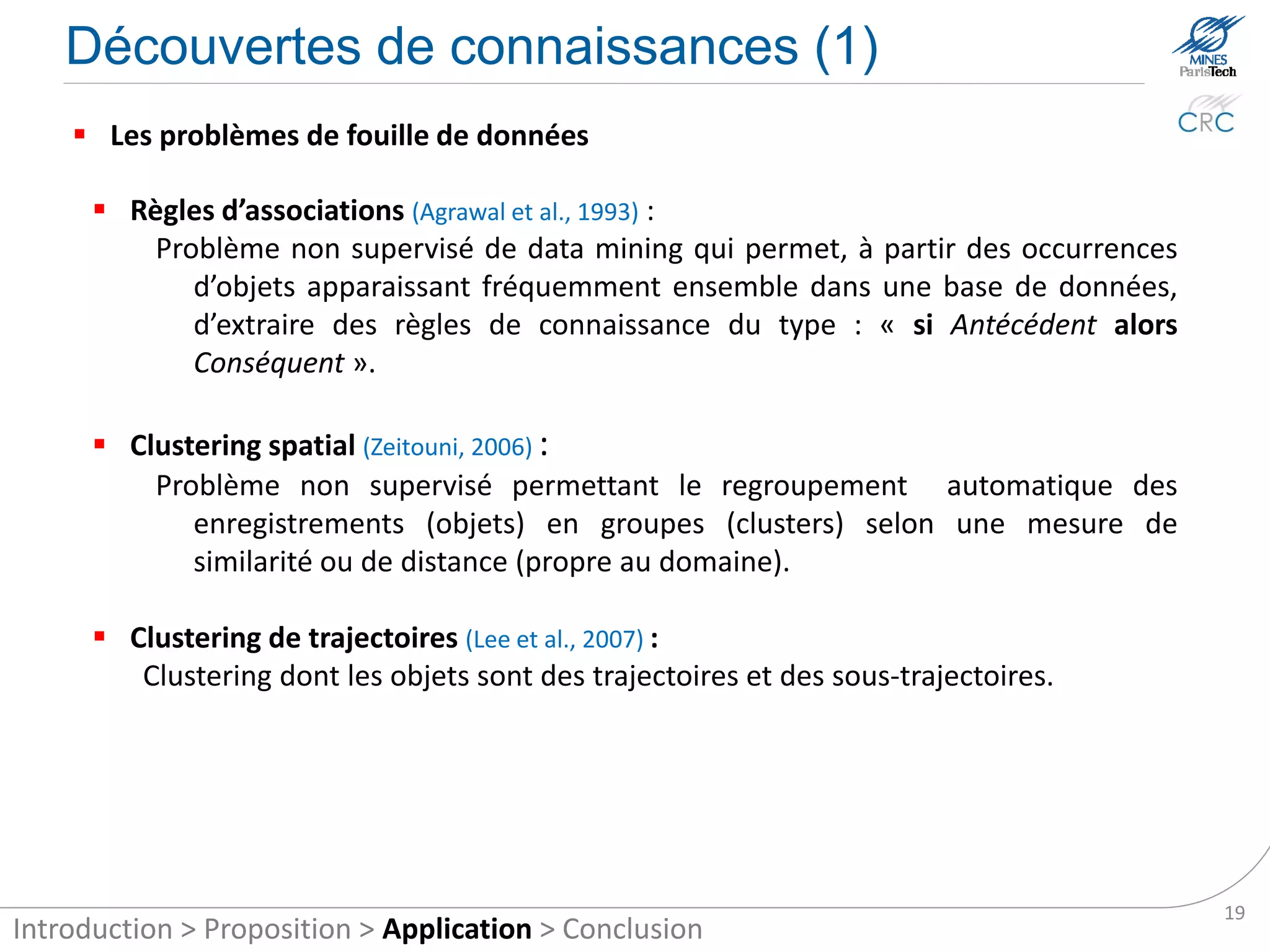
Présentation lors de la conférence IEEE SOSE 2012.
Current maritime traffic monitoring systems are not sufficiently adapted to the identification of maritime accident risk. It is very difficult for operators responsible for monitoring traffic to identify which vessels are at risk among all the shipping traffic displayed on their screen. They are overwhelmed by huge amount of kinematic ship data to be decoded. To improve this situation, this paper proposes a system for the automatic identification of maritime accident risk. The system consists of two modules. The first automates expert knowledge acquisition through the computerized exploration of historical maritime data, and the second provides a rule-based reasoning mechanism.
Call Girls in Dwarka Mor Delhi Contact Us 9654467111
The automatic identification system of maritime accident risk using rule-based reasoning
1. Centre de recherche sur les Risques et les Crises
The automatic identification system of maritime
accident risk using rule-based reasoning
Bilal IDIRI, Aldo NAPOLI
Mines ParisTech
Centre for Research on Risk and Crises
IEEE international conference on System Of Systems Engineering, SOSE’2012
2. Plan
1 Introduction
1 Context
2 The maritime tracking systems
3 Problematic
4 Background
2 Proposition
1 Hypothesis and research objectives
2 Methodological approach
3 Our modelling approach
3 Application to the risk of maritime accidents
1 The databases
2 Knowledge discovery
3 Automatic identification of risks
4 Conclusion and future works
4. Context
The importance of maritime activity
• 90% of international trade,
• 80% of energy transport,
• 50 million passengers each year in Mediterranean Sea,
• 1.19 billion Deadweight tons (dwt) in 2009, 6.7% more
compared to 2008 (CNUCED, 2009).
The sea: a complex environment
• Existence of international free spaces,
• Several coastal states with their own regulations,
• Multitude of actors, we are interested
• Multiplicity of risks (safety and security) in maritime
tracking systems
Several safety and security maritime devices
• Organisms responsible for safety and security,
• Regulations (ENC, legislative packages Erika I, II, III, etc.),
• Systems of navigational aid (NavTrack, Marine GIS, ex-Trem, etc..),
• Maritime tracking systems (Spationav, SIVE, SYTAR, etc..)
4
Introduction > Proposition > Application > Conclusion
5. Maritime tracking systems
Definition: they allow the retrieval and fusion of information on vessels (position,
heading, speed, etc.) for monitoring traffic on a display device.
Data acquisition
infrastructure Control interface Maritime surveillance
operator
Source (DenisGouin, 2010)
Maritime risks are still important
• Worldwide, there are still many thousands of maritime accidents each year,
• 54 700 tonnes of oil and hazardous substances accidentally discharged in 2009 against 7500
tonnes in 2008 (Cedre, 2009)
• 445 acts of piracy recorded (+8.5% in one year) and 1181 marine taken hostages in 2010 (BMI,
2010),
• … 5
Introduction > Proposition > Application > Conclusion
6. Problematic
In our days, the identification of risks with maritime tracking systems are
difficult and complicated.
Why ?
The wide area to be monitored,
The amount of ships at sea (41 million ship positions/day for
Difficult
62,000 ships according to LIoyds),
risk
The multiplicity of scenarios, identification
The risk events that are scattered and fragmented in time and
space,
6
Introduction > Proposition > Application > Conclusion
7. Background (1)
Several earlier studies have addressed the issue of improving maritime tracking systems –
either at the level of the data acquisition infrastructure or at the information processing level.
At the information
processing level
Improving
SM
Automatic
Risk analysis identification
of risks
Numerical
Probabilistic Statistics Clustering modelling Visualization
simulation
(Amrozowicz 1996) (Maio and al. 1991), (J. R. W. Merrick and (Torun and Düzgün (Darpa 2005) (Willems and al. 2009; 2011)
(Amrozowicz and al. 1997) (LeBlanc and Rucks al. 2000), (J. Merrick 2006) (Morel and al. 2008; 2009, (Riveiro and al. 2008; Riveiro
(Kuroda et al. 1982) 1996) and al. 2002) (Marven and al. 2010, 2011) and Goran Falkman 2009;
(Chaze and al., 2012) 2007) (Roy 2008; Roy 2010) Riveiro and Göran Falkman
(Etienne and al. 2010) 2011) (Gouin and al. 2011;
(Cledo 2010) Lavigne and Gouin 2011)
(Nilsson and al. 2008)
(Laere and Nilsson 2009)
(Vandecasteele and
Napoli, 2012)
(IDIRI and Napoli, 2012)
7
Introduction > Proposition > Application > Conclusion
8. Background (2) Improving
SM
Automati
c
Risk
identificat
analysis
ion of
Limitations of this research
risks
Numerical
Probabilis Visualizati
Statistics simulatio Clustering modelling
tic on
n
Maritime knowledge modelling often based on brainstorming (Nilsson et al. 2008)
(Roy 2008) and mathematical modelling:
Interesting but complicated and expensive,
The output scenarii rely heavily on the expert knowledge of individuals,
Knowledge previously known by the experts.
Knowledge modelling by data mining little explored (Darpa 2005):
Easy and allows the discovery of new knowledge,
Scalable.
The definition of maritime risk is based on behavior of vessels (abnormal,
unusual, etc.) and on zoning.
Abnormal behavior does not necessarily correspond to a risk,
Normal behavior can be a risk.
8
Introduction > Proposition > Application > Conclusion
10. Hypothesis and research objectives
There is a need for modelling and automatic identification of maritime
risks.
Hypotheses
Using new data should allow better analysis of maritime risks,
Using new methods of information processing should enable better
identification of risk.
Objectives
Propose a new approach to risk modelling based on data mining,
Propose automated identification of maritime risks,
Extend the definition of maritime risk,
10
Introduction > Proposition > Application > Conclusion
11. Methodological approach (1)
Spatial and temporal decision aid problematic:
Monitoring of vessels operating in an open space,
Decision on the riskiness of a ship or not.
Data mining for risk modelling at sea
Definition: “Discovery of interesting, implicit knowledge in spatial databases, is an
important task for understanding and use of spatial data and knowledge bases“
(Krzysztof and Han, 1995)
The Spatial Data Mining allows automatic exploration data to search for knowledge.
11
Introduction > Proposition > Application > Conclusion
12. Methodological approach (2)
Automatic reasoning for automatic identification of risks
J. Roy (Roy 2010) applied the automated reasoning to automatically identify abnormal
behavior of ships.
Automatic reasoning simulates the human reasoning of a machine to infer new
knowledge from the input events and knowledge previously stored.
Knowledge
CBR RBR
Knowledge Case Case generation
Modularity Problem Rule Selection of rule-based reasoning:
Problem resolution Adapted case Rule application (fast) Easy to understand,
Reasoning Non-deductive Deductive
Modular as rule,
Easy (episodic problem Difficult (how to go about resolving a Deductive reasoning
Acquisition
solving) problem)
12
Introduction > Proposition > Application > Conclusion
13. Methodological approach (3)
Extending the definition of maritime risks as a combination of three concepts:
risk situation, risk behavior and risk area.
• Areas of high density of interesting cases
(maritime accident, drug trafficking, etc.).
Risk area
• Behavior of ships describing
risk situations (outlier path,
slowing, etc.).
Risk
behavior
• Meets of factors suitable for a kind of
risk (weather, oceanography, etc..)
Risk
situation
Complementarities between these three concepts to maximize the chances to identify
risks.
13
Introduction > Proposition > Application > Conclusion
15. Our modelling approach (2) 1
Knowledge
Automatic
The first module involves knowledge acquisition from Acquisition
historical data
Data mining
Events flow
Generation
Operators/experts
Knowledge Knowledge base
in
Interface helps
the validation /
definition of
knowledge
15
Introduction > Proposition > Application > Conclusion
16. Our modelling approach (3) 2
Rule-based
Reasoning
The second module uses knowledge in the task of
automatic risk identification
Knowledge
Knowledge
Rules engine
Applicable 2. Conflict Resolution Selected
1. Match 3. Execution
rules rules
Facts
Facts
16
Introduction > Proposition > Application > Conclusion
18. The databases
MAIB data:
Historical accidents/incidents between 1991 and 2009,
14,900 accidents and incidents,
16,230 ships.
MERRA data:
Provides meteorological data from the period 1991-2009,
Regular download (1 time/day) to supply the facts.
AIS data:
Historical data since ~ 3 months,
Continuous flow of ship movements.
18
Introduction > Proposition > Application > Conclusion
19. Knowledge discovery (1)
Data mining problems
Associations Rules(Agrawal et al., 1993):
is an unsupervised data mining method that allows extracting knowledge rules
of the type “if condition then result” from itemsets that frequently appear
together in a database (an itemset is a set of items and an item is an instance
of a database object).
Spatial Clustering (Zeitouni, 2006):
Problem for unsupervised automatic grouping of records (objects) into groups
(clusters) as a measure of similarity or distance (domain specific).
Clustering of trajectories (Lee et al., 2007):
Clustering whose objects are paths and sub-paths.
19
Introduction > Proposition > Application > Conclusion
20. Knowledge discovery (2)
Risk situation Risk area Risk behaviour
Spatial and temporal
Data mining Spatial data mining
data mining
Spatial and temporal static data Spatial and temporal
(historical) dynamic data (flow)
Accidents investigations Moving Environmental
data vessels data data
20
Introduction > Proposition > Application > Conclusion
21. Association rules application
Risk situation (Idiri and Napoli, 2012)
Accidents and incidents data bases of British ships Apriori algorithm
Package Rattle 2.6.4 de R
14,900 accidents
16,230 ships
years 1991-2009
Résultats
Prediction rules : {Vessel_Category=Fishcatching/processing}{Incident_Type=Machinery Failure}
supp=0.39 ;conf= 0.6 ;lift=1.23.
Targeting Rule : {Vessel_Category=Fishcatching/processing}{Vessel_Type=Trawler}
supp=0.14; conf=0.43 ; Lift=3.
Banal rule : {Vessel_Category=Passenger}{Pollution_Caused=No}
supp=0.15; conf=0.73; lift=1.2.
21
Introduction > Proposition > Application > Conclusion
22. Clustering application
Risk area
Methods for density (DBSCAN, OPTICS, etc..)
Automatic identification of the number of clusters,
Cluster with random shapes..
Choice of algorithm OPTICS (Ankerst et al. 1999)
Accidents and incidents data bases of British ships OPTICS algorithm
Framework Java ELKI 0.4.0
22
Introduction > Proposition > Application > Conclusion
23. Clustering trajectories application
Risk behavior
• Discovery of aberrant trajectories (Trajectory Outlier) and especially the sub-
trajectories (Outlying sub-trajectory) that do not follow the same trend as the
other sub-trajectory.
Source (J. Lee, 2008)
TRAOD Algorithm (TRAjectory Outlier Detection) (Lee et al. 2008)
in 2 steps:
1. Partition: Each trajectory is partitioned into an
set of t-partitions,
2. Detect: Outlying t-partitions are identified
based on the distance of neighboring trajectories.
Source (J. Lee, 2008)
23
Introduction > Proposition > Application > Conclusion
24. Automatic identification of risks
Association rules example
Rule {Location = Coastal waters, Vessel_Category =
Fishing/processing, Age_Slice_Of_Vessel = 11 to 18
years}
{Incident_Type = Machinery Failure}
Measures support = 0.086 confidence = 0.725 lift = 1.47
Interpretation If there is a fishing vessel, aged 11-18 years, sailing in
coastal waters then there is a risk that it will break down.
Add rules in Drools (Drools 5.4.0 Jboss Rules)
• Add rules :
Rules “Risk of mechanical failure”
when
$s: ship (location= = “Coastal waters”, ship class ==“fishing”,
• Add a fact:
age ≥ 11, age ≤ 18)
Rule “Add Ship Course”
then
check_behavior ($s.id_ship);
When then
end
insert (new Course ());
Rules “Behavior: drifting of course”
end
when
$r: risk (Type==”Mechanical failure”)
course (behavior==”Drifting”)
then
channel[“alerts”].send(new Alert());
end
24
Introduction > Proposition > Application > Conclusion
25. Conclusion and future works
Results
New approach to the modelling of maritime risks based on data mining,
Real-time identification of maritime risk by automatic reasoning,
Improving the identification of maritime risks by extending the definition of
maritime risk.
Future works
Implementing the sub-trajectory clustering on AIS data,
Designing and implementing the interface for definition and validation of
knowledge,
Studying the real-time mobile database (frequent updates).
25
Introduction > Proposition > Application > Conclusion
26. ?
Centre de recherche sur les Risques et les Crises
Thanks for attention
Bilal IDIRI
PhD student Personal page http://perso.crc.mines-paristech.fr/~idiri)
Phone: +33 (0) 4 93 95 75 77 Fax. : +33 (0) 4 93 95 75 81
E-mail: : bilal.idiri@mines-paristech.fr