SmartMet Server
In a Nutshell
• Data and product server for MetOcean data
• High capacity & availability
• Data is extracted and products generated always on-demand
• INSPIRE Compliant
• Operative since 2008
• FMI client services (since 2008)
• Finnish Meteorological Institute (FMI) Open Data Portal (since 2013)
5/17/2016 SmartMet Server | ALPO 05/2016 | IL, Roope Tervo 2
In a Nutshell
• Several input sources
• GRIB-, NetCDF-, etc. files (multi-dimensional grid data)
• PostGIS database (vectors)
• Point database (point observations)
• Several output interfaces and formats
• WMS, WFS 2.0
• JSON, XML, ASCII, XML, HTML, SERIAL
• GRIB1, GRIB2, NetCDF
5/17/2016 SmartMet Server | ALPO 05/2016 | IL, Roope Tervo 3
Usage
5/17/2016 SmartMet Server | ALPO 05/2016 | IL, Roope Tervo 4
FMI Open Data
Portal & FMI
INSPIRE Data
Services
Backend for
clients’ web
services
Integration to
clients’
systemsBackend for
mobile
applications
Backend for
FMI Client
Services
Backend for
FMI public
pages
• Basis of FMI product generation
Architecture
5/17/2016 SmartMet Server | ALPO 05/2016 | IL, Roope Tervo 5
• Frontend
• Load balancer
• Knowledge about
backend services
• Backend
• Different backends may
contain different
services
• Plugin-based architecture
• Engines provides
shared access to the
data
• Plugins provides APIs
based on services
provided by engines
Frontend
5/17/2016 SmartMet Server | ALPO 05/2016 | IL, Roope Tervo 6
• Provides HTTP 1.1 server
• Chunked, gzip and no encoding supported
• No full standard compliance
• Monitors status of backend services
• Forwards requests to the
backends with required services
• Load balancing
• Different queues for fast and
slow services
• Provides LRU product cache
Frontend
cache
5/17/2016 SmartMet Server | ALPO 05/2016 | IL, Roope Tervo 7
• Cache contains two phase mapping of product
• ETags works as product hash
• Consists of request url, product configuration and used data
• If any of above changes, product is
deprecated
• ETags are mapped to buffer hash
• Data is stored based on buffer hash
• For example transparent radar images
without rain are all mapped to as one
cache entry
• Significant affect to cache size
• LRU cache
• Most used content in memory
• Rarely used content on local disk
Data Sources
qengine
5/17/2016 SmartMet Server | ALPO 05/2016 | IL, Roope Tervo 10
• Provides access to grid data
• Supported data formats: querydata
• Ready tools for converting other
formats (grib, netcdf, hdf…) to
querydata
• Memory-maps the data from NFS
• Supports both spatial and temporal
interpolation and nearest point
selection
• Used method depends on the
parameter
• Selects the best data source for
requested region
Data Sources
qengine
5/17/2016 SmartMet Server | ALPO 05/2016 | IL, Roope Tervo 11
• Post-processing capabilities
• Corrects the data based on accurate DEM (up to 30 meter resolution) and
land/water information
• Correlation done to temperature based on the difference between model and real
topography
• Land/water information
used to give more
weight on corresponding
grid points in
interpolation
• Calculates derivative
parameters
• FeelsLike, sunset,
day length…
Data Sources
obsengine
5/17/2016 SmartMet Server | ALPO 05/2016 | IL, Roope Tervo 12
• Provides access to
observation data stored in SQL
database
• Keeps local SpatiaLite
database for latest data
• Sync with the master database
• Requests not available in the
cache are forwarded to master
database
Data Sources
geoengine
5/17/2016 SmartMet Server | ALPO 05/2016 | IL, Roope Tervo 13
• Provides location services
for other services
• Resolve location information
for coordinates and vice
versa
• Based on geonames.org
• PostGIS database
• Synced from geonames.org
to local database once a day
WMS
5/17/2016 SmartMet Server | ALPO 05/2016 | IL, Roope Tervo 14
• Version 1.3.0
• Supports png, svg, jpeg, tiff
• Supports all proj.4 projections
• Supports for time and other custom dimensions
• Data sources: grid data and PostGIS
• Contours coverages and isolines on-fly from grid data (qengine)
• Draws PostGIS geometries based on database queries
• Generates SVG which are rendered to requested raster format
• Supports rich effects of SVG rendering model
• Styling with CSS
• Rendering done with librsvg
• Configuration with json
• Configuration variables can be overridden in requests (i.e. thresholds)
WMS
5/17/2016 SmartMet Server | ALPO 05/2016 | IL, Roope Tervo 15
• Support for meteorological specific visualizations
• Wind barbs, wind arrows, fronts, jets…
• Support for thresholds
• i.e. draw images only where temperature is between -2 and 2 degrees
• Also possibility to mask content based on other parameter (i.e. draw
precipitation areas only where wind gusts are over 8 m/s)
• Very efficient cache
• Supports frontend product cache
• Several LRU caches in backend
• For contours, SVG products and ready rendered products
• Performance up to 3000 req/s
• With FMI setup
Dali
5/17/2016 SmartMet Server | ALPO 05/2016 | IL, Roope Tervo 16
• Provides images from grid data
• Same plugin as WMS
• Richer but non-standard API
• Support for several views in
one image
• i.e. same area with different
times side by side
• Support all SVG effects
• Possible to center location
based on location name
WFS
5/17/2016 SmartMet Server | ALPO 05/2016 | IL, Roope Tervo 17
• Version 2.0.0 Basic Profile
• INSPIRE Compliant
• Support all proj.4 projections
• Capabilities: ImplementsQuery, ImplementsAdHocQuery, ImplementsMinStandardFilter,
ImplementsMinSpatialFilter, ImplementsMinTemporalFilter
• Supports KVP- and XML-encodings
• Support for simple and complex features
• Data sources: grid data (qengine) and observation data (obsengine)
• Point forecasts from grid data
• Contours from grid data
• Observations from obsengine
• Most of the data provided via stored queries to access good enough
performance
Download (WCS-like)
5/17/2016 SmartMet Server | ALPO 05/2016 | IL, Roope Tervo 18
• Provides grid data (from qengine) as binary data
• Supported output formats: GRIB1, GRIB2, NetCDF and Querydata,
• Supports all proj.4 projections (depends on output format support)
• Supports slicing by
• area (bbox)
• elevation (pressure and/or model level)
• time (start time, end time and origin time)
• Possibility to define grid resolution by
• selecting every Nth grid point to x and y direction
• grid size  data is interpolated to new grid points
TimeSeries
5/17/2016 SmartMet Server | ALPO 05/2016 | IL, Roope Tervo 19
• Provides observations and point forecasts to the point
• Output formats: JSON, XML, ASCII, XML, HTML, SERIAL
• Support for aggregate values over time and area
• Median, mean, min, max, sum, avg, integ, sdev, trend, change, count,
percentage
• Support for combining different models
• Giving two models cause first one to be
supplemented with second one after time
range of first one ends
• One or more locations per query
• Possible selection methods: name, coordinates, set of locations, location id,
bbox, path, WKT
Autocomplete
5/17/2016 SmartMet Server | ALPO 05/2016 | IL, Roope Tervo 20
• Provides autocomplete server for searching locations
• Very efficient, very fast
• Location information enriched with
simple weather information
(temperature, weather symbol, etc…)
• Location information stored in location
database (geoengine)
Q3 (WPS-like)
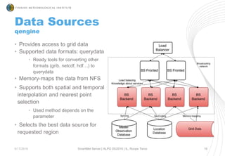
5/17/2016 SmartMet Server | ALPO 05/2016 | IL, Roope Tervo 21
• Provides service to process the
data and return output as data or
image
• Input: LUA scripts
• Output formats
• Matrix as text
• Matrix as binary (querydata)
• JSON
• Contoured images: svg, png,
jpeg, pdf
local param= T
local limit= 0
local r,err= HIR{ hybrid=true, params={param,Z,P} }
assert(r,err)
-- Iterate levels from down to up
-- Store height and pressure when >= 'limit' (last
will remain)
local m_Z= matrix() -- heights collected; originally
all 'nan'
local m_P= matrix() -- pressures collected
local m_v= matrix() -- value at such positions (not
needed)
for g in grids_by_level(r) do
for pos,v in points(g[param]) do
if v>=limit then
m_Z[pos]= g.Z[pos]
m_P[pos]= g.P[pos]
m_v[pos]= v
end
end
end
return m_Z, m_P, m_v
FMI Setup
5/17/2016 SmartMet Server | ALPO 05/2016 | IL, Roope Tervo 22
• 2 frontends
• RAM: 256G
• CPU: 24x 2.10GHz
• OS: RHEL7
• 5 backends
• RAM: 12G
• CPU: 24x2.50GHz
• OS: RHEL7
• Load Balancer
• F5 BIG IP 11
• Databases
• Master Observation
Database: Oracle
• Location Database:
PostGIS 9.5
Performance
5/17/2016 SmartMet Server | ALPO 05/2016 | IL, Roope Tervo 23
• Production (with FMI setup)
• > 30 000 000 req/day
• Baseline 200 req/s
• Peaks over 650 req/s (20.6.2015 13:02)
• Average response times varies depending on the request:
• WFS: 140 ms/req, WMS: 130 ms/req, Timeseries: 30 ms/req,
Autocomplete: 4 ms/req
• Overall average: 70 ms/req
• Over 99,95% availability
Performance
5/17/2016 SmartMet Server | ALPO 05/2016 | IL, Roope Tervo 24
• Load testing (production setup):
• Peaks over 4300 req/s
• Avg 173 ms, 95% of responses in 244 ms, median 54 ms
• Slow query queue easy to DoS due to possibility to large data
requests and heavy operations
• Don’t affect to fast query queue
Roadmap for the 2016
5/17/2016 SmartMet Server | ALPO 05/2016 | IL, Roope Tervo 25
Native GRIB support for input data
Support for GRIB data as input
data without converting data to
internal data format
WCS support
Implement WCS interface for
download plugin
Clustering support over Internet
Possibility to provide data from
it’s original source via single
API (i.e. ECMWF data from
UK and Hirlam from Finland)
Open Source
• SmartMet Server is going to be published as Open Source in
2016
• Scope
• Server: Libraries, Engines, Plugins
• Tools to handle data: qdconversion- & qdtools-paketit
• Licence most probably GPL or MIT
• Publishing in https://github.com/fmidev
5/17/2016 SmartMet Server | ALPO 05/2016 | IL, Roope Tervo 26
Strengths
• SmartMet Server can
• Visualize, extract and post-process large data sets
• Utilize data from grid-files (GRIB, NetCDF, HDF…), PostGIS database
and point databases
• Use SmartMet Server when
• You need to handle weather or climatological data (or any multi-
dimensional grid data)
• You need fast and reliable web server
• You may consider using SmartMet Server also in more traditional
context
• It’s fast, it’s reliable
5/17/2016 SmartMet Server | ALPO 05/2016 | IL, Roope Tervo 27
https://www.facebook.com/fmibeta
http://www.slideshare.net/tervo
https://github.com/fmidev
http://roopetervo.com

SmartMet Server OSGeo

  • 1.
  • 2.
    In a Nutshell •Data and product server for MetOcean data • High capacity & availability • Data is extracted and products generated always on-demand • INSPIRE Compliant • Operative since 2008 • FMI client services (since 2008) • Finnish Meteorological Institute (FMI) Open Data Portal (since 2013) 5/17/2016 SmartMet Server | ALPO 05/2016 | IL, Roope Tervo 2
  • 3.
    In a Nutshell •Several input sources • GRIB-, NetCDF-, etc. files (multi-dimensional grid data) • PostGIS database (vectors) • Point database (point observations) • Several output interfaces and formats • WMS, WFS 2.0 • JSON, XML, ASCII, XML, HTML, SERIAL • GRIB1, GRIB2, NetCDF 5/17/2016 SmartMet Server | ALPO 05/2016 | IL, Roope Tervo 3
  • 4.
    Usage 5/17/2016 SmartMet Server| ALPO 05/2016 | IL, Roope Tervo 4 FMI Open Data Portal & FMI INSPIRE Data Services Backend for clients’ web services Integration to clients’ systemsBackend for mobile applications Backend for FMI Client Services Backend for FMI public pages • Basis of FMI product generation
  • 5.
    Architecture 5/17/2016 SmartMet Server| ALPO 05/2016 | IL, Roope Tervo 5 • Frontend • Load balancer • Knowledge about backend services • Backend • Different backends may contain different services • Plugin-based architecture • Engines provides shared access to the data • Plugins provides APIs based on services provided by engines
  • 6.
    Frontend 5/17/2016 SmartMet Server| ALPO 05/2016 | IL, Roope Tervo 6 • Provides HTTP 1.1 server • Chunked, gzip and no encoding supported • No full standard compliance • Monitors status of backend services • Forwards requests to the backends with required services • Load balancing • Different queues for fast and slow services • Provides LRU product cache
  • 7.
    Frontend cache 5/17/2016 SmartMet Server| ALPO 05/2016 | IL, Roope Tervo 7 • Cache contains two phase mapping of product • ETags works as product hash • Consists of request url, product configuration and used data • If any of above changes, product is deprecated • ETags are mapped to buffer hash • Data is stored based on buffer hash • For example transparent radar images without rain are all mapped to as one cache entry • Significant affect to cache size • LRU cache • Most used content in memory • Rarely used content on local disk
  • 8.
    Data Sources qengine 5/17/2016 SmartMetServer | ALPO 05/2016 | IL, Roope Tervo 10 • Provides access to grid data • Supported data formats: querydata • Ready tools for converting other formats (grib, netcdf, hdf…) to querydata • Memory-maps the data from NFS • Supports both spatial and temporal interpolation and nearest point selection • Used method depends on the parameter • Selects the best data source for requested region
  • 9.
    Data Sources qengine 5/17/2016 SmartMetServer | ALPO 05/2016 | IL, Roope Tervo 11 • Post-processing capabilities • Corrects the data based on accurate DEM (up to 30 meter resolution) and land/water information • Correlation done to temperature based on the difference between model and real topography • Land/water information used to give more weight on corresponding grid points in interpolation • Calculates derivative parameters • FeelsLike, sunset, day length…
  • 10.
    Data Sources obsengine 5/17/2016 SmartMetServer | ALPO 05/2016 | IL, Roope Tervo 12 • Provides access to observation data stored in SQL database • Keeps local SpatiaLite database for latest data • Sync with the master database • Requests not available in the cache are forwarded to master database
  • 11.
    Data Sources geoengine 5/17/2016 SmartMetServer | ALPO 05/2016 | IL, Roope Tervo 13 • Provides location services for other services • Resolve location information for coordinates and vice versa • Based on geonames.org • PostGIS database • Synced from geonames.org to local database once a day
  • 12.
    WMS 5/17/2016 SmartMet Server| ALPO 05/2016 | IL, Roope Tervo 14 • Version 1.3.0 • Supports png, svg, jpeg, tiff • Supports all proj.4 projections • Supports for time and other custom dimensions • Data sources: grid data and PostGIS • Contours coverages and isolines on-fly from grid data (qengine) • Draws PostGIS geometries based on database queries • Generates SVG which are rendered to requested raster format • Supports rich effects of SVG rendering model • Styling with CSS • Rendering done with librsvg • Configuration with json • Configuration variables can be overridden in requests (i.e. thresholds)
  • 13.
    WMS 5/17/2016 SmartMet Server| ALPO 05/2016 | IL, Roope Tervo 15 • Support for meteorological specific visualizations • Wind barbs, wind arrows, fronts, jets… • Support for thresholds • i.e. draw images only where temperature is between -2 and 2 degrees • Also possibility to mask content based on other parameter (i.e. draw precipitation areas only where wind gusts are over 8 m/s) • Very efficient cache • Supports frontend product cache • Several LRU caches in backend • For contours, SVG products and ready rendered products • Performance up to 3000 req/s • With FMI setup
  • 14.
    Dali 5/17/2016 SmartMet Server| ALPO 05/2016 | IL, Roope Tervo 16 • Provides images from grid data • Same plugin as WMS • Richer but non-standard API • Support for several views in one image • i.e. same area with different times side by side • Support all SVG effects • Possible to center location based on location name
  • 15.
    WFS 5/17/2016 SmartMet Server| ALPO 05/2016 | IL, Roope Tervo 17 • Version 2.0.0 Basic Profile • INSPIRE Compliant • Support all proj.4 projections • Capabilities: ImplementsQuery, ImplementsAdHocQuery, ImplementsMinStandardFilter, ImplementsMinSpatialFilter, ImplementsMinTemporalFilter • Supports KVP- and XML-encodings • Support for simple and complex features • Data sources: grid data (qengine) and observation data (obsengine) • Point forecasts from grid data • Contours from grid data • Observations from obsengine • Most of the data provided via stored queries to access good enough performance
  • 16.
    Download (WCS-like) 5/17/2016 SmartMetServer | ALPO 05/2016 | IL, Roope Tervo 18 • Provides grid data (from qengine) as binary data • Supported output formats: GRIB1, GRIB2, NetCDF and Querydata, • Supports all proj.4 projections (depends on output format support) • Supports slicing by • area (bbox) • elevation (pressure and/or model level) • time (start time, end time and origin time) • Possibility to define grid resolution by • selecting every Nth grid point to x and y direction • grid size  data is interpolated to new grid points
  • 17.
    TimeSeries 5/17/2016 SmartMet Server| ALPO 05/2016 | IL, Roope Tervo 19 • Provides observations and point forecasts to the point • Output formats: JSON, XML, ASCII, XML, HTML, SERIAL • Support for aggregate values over time and area • Median, mean, min, max, sum, avg, integ, sdev, trend, change, count, percentage • Support for combining different models • Giving two models cause first one to be supplemented with second one after time range of first one ends • One or more locations per query • Possible selection methods: name, coordinates, set of locations, location id, bbox, path, WKT
  • 18.
    Autocomplete 5/17/2016 SmartMet Server| ALPO 05/2016 | IL, Roope Tervo 20 • Provides autocomplete server for searching locations • Very efficient, very fast • Location information enriched with simple weather information (temperature, weather symbol, etc…) • Location information stored in location database (geoengine)
  • 19.
    Q3 (WPS-like) 5/17/2016 SmartMetServer | ALPO 05/2016 | IL, Roope Tervo 21 • Provides service to process the data and return output as data or image • Input: LUA scripts • Output formats • Matrix as text • Matrix as binary (querydata) • JSON • Contoured images: svg, png, jpeg, pdf local param= T local limit= 0 local r,err= HIR{ hybrid=true, params={param,Z,P} } assert(r,err) -- Iterate levels from down to up -- Store height and pressure when >= 'limit' (last will remain) local m_Z= matrix() -- heights collected; originally all 'nan' local m_P= matrix() -- pressures collected local m_v= matrix() -- value at such positions (not needed) for g in grids_by_level(r) do for pos,v in points(g[param]) do if v>=limit then m_Z[pos]= g.Z[pos] m_P[pos]= g.P[pos] m_v[pos]= v end end end return m_Z, m_P, m_v
  • 20.
    FMI Setup 5/17/2016 SmartMetServer | ALPO 05/2016 | IL, Roope Tervo 22 • 2 frontends • RAM: 256G • CPU: 24x 2.10GHz • OS: RHEL7 • 5 backends • RAM: 12G • CPU: 24x2.50GHz • OS: RHEL7 • Load Balancer • F5 BIG IP 11 • Databases • Master Observation Database: Oracle • Location Database: PostGIS 9.5
  • 21.
    Performance 5/17/2016 SmartMet Server| ALPO 05/2016 | IL, Roope Tervo 23 • Production (with FMI setup) • > 30 000 000 req/day • Baseline 200 req/s • Peaks over 650 req/s (20.6.2015 13:02) • Average response times varies depending on the request: • WFS: 140 ms/req, WMS: 130 ms/req, Timeseries: 30 ms/req, Autocomplete: 4 ms/req • Overall average: 70 ms/req • Over 99,95% availability
  • 22.
    Performance 5/17/2016 SmartMet Server| ALPO 05/2016 | IL, Roope Tervo 24 • Load testing (production setup): • Peaks over 4300 req/s • Avg 173 ms, 95% of responses in 244 ms, median 54 ms • Slow query queue easy to DoS due to possibility to large data requests and heavy operations • Don’t affect to fast query queue
  • 23.
    Roadmap for the2016 5/17/2016 SmartMet Server | ALPO 05/2016 | IL, Roope Tervo 25 Native GRIB support for input data Support for GRIB data as input data without converting data to internal data format WCS support Implement WCS interface for download plugin Clustering support over Internet Possibility to provide data from it’s original source via single API (i.e. ECMWF data from UK and Hirlam from Finland)
  • 24.
    Open Source • SmartMetServer is going to be published as Open Source in 2016 • Scope • Server: Libraries, Engines, Plugins • Tools to handle data: qdconversion- & qdtools-paketit • Licence most probably GPL or MIT • Publishing in https://github.com/fmidev 5/17/2016 SmartMet Server | ALPO 05/2016 | IL, Roope Tervo 26
  • 25.
    Strengths • SmartMet Servercan • Visualize, extract and post-process large data sets • Utilize data from grid-files (GRIB, NetCDF, HDF…), PostGIS database and point databases • Use SmartMet Server when • You need to handle weather or climatological data (or any multi- dimensional grid data) • You need fast and reliable web server • You may consider using SmartMet Server also in more traditional context • It’s fast, it’s reliable 5/17/2016 SmartMet Server | ALPO 05/2016 | IL, Roope Tervo 27
  • 26.