SlideShare a Scribd company logo
1 of 20
Download to read offline
Urban Planning Project SATIATED TOWN
SATIATED TOWN
Project report
URBAN PLANING
Urban Planning Project SATIATED TOWN
Content
Prologue:
1.0 Introduction
- The Vision
- Purpose and Goals
- Objectives and Targets
- Pistachio trees
2.0 Sustainability
- Sustainability strategies
3.0 Master plan
- Master plan description
- Skyline
- Block arrangement
4.0 Design Guidelines
- Standards
- Attribution and Densities
Urban Planning Project SATIATED TOWN
Prologue
Zarqa (Arabic: ‫)الزرقاء‬ is a city in Jordan located to the northeast of Amman. At 792,665 inhabitants
(2000), comprising 15.5% of Jordan's population, it is the country's second largest city. Zarqa is the
capital of Zarqa Governorate Its name means "the blue one." It's the industrial capital of Jordan, with
many factories around the perimeter and Jordan's major oil refinery. Also, it functions as a large military
center, with several military camps and firing ranges in the area.
 Location:
Our site is located 25 km east of the Jordanian capital Amman. The second largest city in the
governorate is Russeifa next to Hashemiyya and Al-Qasaba.
 History:
Our site location has no previous clear human settlement; due to that it has no previous character or
recognizable identity, in addition we can also notice that the surrounded area is also empty and not
exploited by any means.
 Climate:
The area characterized by a severe lack of available water, to the extent of hindering or preventing
the growth and development of plant and animal life. Environments subject to arid climates tend to lack
vegetation and are called xeric or desert related Plants.
 Future Vision
Our site is one of the important locations in the area, where it's included in the Jordanian ministry of
agriculture development projects as a land of agricultural production. And it gained an extra value
because it's located next to the Hashemite University.
Urban Planning Project SATIATED TOWN
1.0 Introduction
- The Vision
- Purposes and Goals
- Objectives and Targets
Urban Planning Project SATIATED TOWN
Our Vision
Our vision is to create a sustainable and productive community, which provides a good quality of live
while eliminating the influence of human activity on the environment.
Driven by the means of a sustainable city, we came closer to the main themes of sustainability which
include:
1. TRANSPORTATION (movement of goods and people).
2. ENERGY (for buildings, transportation, manufacturing, and agriculture).
3. DESIGN (built environment - especially buildings and roads).
4. HABITAT (urban green spaces, water areas, and rural environment).
5. FOOD (farms & urban markets, heritage crops/animals, urban gardens).
6. NATURAL CAPITAL (maintaining land, water, soil, natural materials).
7. WASTE (processing of wastes, recycling, efficient design, and conversion to energy).
8. HEALTH (clean air and water, safety, tranquility, environmental needs of vulnerable groups).
9. RECREATION (urban, rural, and agricultural).
10. SENSE OF PLACE (feeling of belonging, sense of community, and stewardship).
We focused on the two themes of sustainability food and sense of place and we mean by
those:
1. Food (In the past, much of the food for a city came from its surrounding region. In many
countries, however, local supply has been replaced by national and international food distribution
systems. Encouraging use of locally produced food could reduce the energy use and pollution
of long-distance transportation. It would have two other benefits: fresher food for urban residents
and higher incomes for local farmers. If such a project included heritage crops and meats, it
could help maintain agricultural biodiversity. Development of urban gardens is another way to
provide city residents with fresh food, as well an enjoyable pastime).
2. Sense of Place (A city that contains natural areas, that is easy to get around in and where
people do not feel oppressed by traffic tends to encourage residents to explore more of their
surroundings. This exploration increases the vitality of the city. At the same time, positive
contacts with other people and nature give them a sense of belonging. Where people feel they
belong, they share a sense of community. This usually leads to greater participation in civic
activities and more volunteers to help others in need. This participation can make it easier to
govern a city and to address social problems. In rural areas, maintaining the traditional sense of
community is related to opportunities for young people to remain in the hamlets and on the
farms. Citizens who take part in civic life, in either urban or rural areas, tend to learn more about
the role that the environment plays in their well-being. Such knowledge could be a starting point
for a project of environmental stewardship).
Based on that, two clear urban models can be taken in consideration:
 The most suitable example for the theme "FOOD" could be the "Broadacre city" for Frank Lloyd
Wright.
 In the other hand the "Earthly paradise" for Rasem Badran is a perfect example for the "SENSE
OF PLACE" theme.
Urban Planning Project SATIATED TOWN
Goals
Our vision is translated into 4 main goals that achieve the aimed concept
1- Creating a solid framework of transportation, land use, and public spaces that integrates the
existing ecological conditions of the Hashemite district.
2- Response to the climate of Zarqa city (Hashemite district).
3- Promotion of high density community and integrated public transit.
4- Appropriate street network and pedestrian friendly walkways, which encourage walkability.
5- Creating a clear character for the town.
After 15-20 years of launching the project of the
(satiated town), it will accommodate 30.000
residents, and 2500 employees per day.
Urban Planning Project SATIATED TOWN
Objectives and targets
Goals (1): Creating a solid framework of transportation, land use,
and public spaces that integrates the existing conditions of the
Hashemite district.
Objectives:
1. High connectivity street network cooperated with well controlled traffic amount and
magnitude.
Targets:
- Choosing a centralized form for the master plan layout, and dividing the
neighborhoods in a radial axis, creating 6 neighborhoods.
- Designing a wide street sections that links the main facilities and utilities along
a major ring road.
- Distributing streets hierarchy in a way that control the traffic size and orientation
by using a main-32 ROW ring road that is linked by a radial 14- ROW local
streets.
2. Feasible and practical land use configuration
Targets:
- Locating the commercial zone along a pedestrian contentious path that eliminates
any interaction with moving vehicles.
- Locating the educational and open space blocks along the major ring road to
provide smooth accessibility.
- Locating main services in the center of the whole town, to increase its
importunacy.
3. Feasible and practical land use configuration
Targets:
- Locating the commercial zone along a pedestrian contentious path that eliminates
any interaction with moving vehicles.
- Locating the educational and open space blocks along the major ring road to
provide smooth accessibility.
- Locating main services in the center of the whole town, to increase its
importunacy.
Goals (2): Response to the climate of Zarqa city (Hashemite district).
Objectives:
1. Respecting the arid land characteristics that are entangled with its hot dry climate and lack
of vegetation and water sources.
Targets:
- Customizing 45% of the total project area for agriculture usage, by increasing
residential densities.
- Choosing pistachio trees as the main productive plant for the town, due to its
special characteristics.
- Collect waste and gray water for irrigation purposes, and integrate rain water
harvesting in all housing unit design.
2. Creating a suitable walkable friendly town, that reduces the effect of the high solar
radiation
Targets:
- Distributing pedestrian contentious paths in a way to be adjacent two relatively
mid-rise buildings, to provide well shaded pedestrian paths.
- Planting trees along all pedestrian pathways and sidewalks to provide shading
area.
- Creating narrow footpaths between mixed use buildings that work as air cooling
alleys.
3. Finding creative and new methods and strategies to increase soil quality and improve its
properties.
Targets:
- Using pistachio shells as compost for soil rather than buying expensive
manufactured composts.
- Choosing the Pistachio tree as the main productive sources gradually improve
soil minerals percentages.
Urban Planning Project SATIATED TOWN
Goals (3): Promotion of high density community and integrated
public transit.
Objectives:
1. Creating an efficient linkage between city center, utilities and housing units.
Targets:
- Locating a ring road around the city center with radius of 270 meters in length,
this links the whole city with a main public transportation lines, achieving a
coherent urban fabric.
- Arranging utilities and services in way to serve the whole town in a way that is
closer to higher densities residential units.
- Providing all walkthrough paths that link the center of the town with all
neighborhood edges.
2. Classifying and arranging population into different densities that are proportional to
different height level.
Targets:
- Reducing the residential area percentage to 25% and locating it near to the town
center In order to provide appropriate utilities and services distribution.
- Distributing population into 3 main density base category (low, medium, high)
that vary between 4 types of housing units.
- Promoting mid-rise housing units that rise between (4-12) storeys.
- Design a set of regulation for each type of the housing unit that rules the height,
setback, buildable area, and parking limitations.
Goals (4): Appropriate street network and pedestrian friendly
walkways, which encourage walkability.
Objectives:
1. Feasible land use arrangement.
Targets:
- Arranging the services in the center with easy pedestrian access, by providing the
appropriate street design and furniture.
- Arranging the educational facilities near the main ring road (public transit) to
eliminate the usage of privet mobile.
- Organizing the commercial facilities in a row of double display facades, with
wide pedestrian path along, in a length of 270 meters.
2. Practical street hierarchy the eliminate traffic jam and cars rush.
Targets:
- Surrounding the neighborhoods with local safe narrow streets rather than high
traffic streets to encourage walkability rather than mobile usage.
- Using the circular shape to reduce cars speed, especially inside local streets.
- Increasing sidewalks width to reduce private mobile usage.
- Increasing street block width to decrease the number of streets cutting through
the neighborhood.
3. Promoting and reinforcing the idea of walkable community.
Targets:
- Paying attention to street furniture and side walk paving and managing water
drainage.
- Providing well shading pathways by increasing the buildings heights and
choosing the appropriate planting patterns.
- Providing a great variety design in all pathways, by changing street design and
street width.
- Arranging everyday needs in less than 5 minute walking distance.
Urban Planning Project SATIATED TOWN
Goals (5): Creating a clear character for the town.
Objectives:
1. Giving the town a unique industry associated with agriculture.
Targets:
- Planting the unique pistachio trees in more than 45% of the project area.
- Creating a profitable industry that is related to the pistachio tree production, with
a proximate income of 1 million JD a year.
2. Dividing the project into 6 recognizable neighborhoods.
Targets:
- Creating a clear diverse neighborhood edges (main streets, commercial paved
pathways, town center (social edge), and agriculture).
- Distributing cultural centers with different functions in each neighborhood.
- Arranging nodes focal points, intersections in each neighborhood.
3. The enactment of lows relating to well identified architectural style and spirit.
Targets:
- Setting specific regulations for each density including (setback, heights, roof
garden, elevations details, buildable area, paring arrangements).
- Binding the usage of Jordanian stone on all four elevations.
- Using a clear set of colors and materials in all town designs.
Urban Planning Project SATIATED TOWN
- Satiated City Skyline
The Satiated city skyline will be dynamic, undulating environment of mid- rise and low rise
buildings, providing the site with a great view and image of 21st
century city. Several key
principles were established;
- The skyline should be dramatic and memorable from many different angles.
- The agricultural zone will be seen from all view points in the satiated city.
- Building heights set up from the agriculture zones to the ring road edges, and
become lower again around the central plaza.
- All buildings in the core area (around the ring road) will have views to the center
and the agricultural area, creating excellent real estate value.
- Cultural and civic buildings are interspersed at key points throughout the plan-
not just around the central park- creating amenities for all and foreground for the
high density behind.
- The skyline will continue to evolve over time and take on new characteristics as
building are designed and constructed.
The Satiated City skyline
Urban Planning Project SATIATED TOWN
- Block structure and Densities arrangement
A fundamental requirement of the satiated town is that blocks should include one type of housing units,
with minimum setback of 4.7 meters to frame the block and to provide a strong street frontage. This will
form active street edges where a mix of uses can occur. High density buildings that stand along on
blocks and are set well back from the street are not allowed.
High density building should be carefully arranged within the core area. Taller buildings should be
arranged along the ring road and gradually step down toward the water in order to maximize the views to
the central park and the green agricultural area.
Block does not exceed 80 meters in width, 230 meters on length, to provide a better circulation inside the
neighborhood; each block should be surrounded with 4 meters side walk, with planting on both sides.
Urban Planning Project SATIATED TOWN
2.0 Sustainability
Sustainability strategies
Countries around the world are developing sustainability standards for green building codes government
and developers are recognizing the critical need and benefit of conserving resources and enhancing local
environment for the health, safety, and welfare of its citizens.
At Satiated Town environmental sustainability must be acknowledged and built into every facet of the
project. Elements of street orientation and distribution, building heights and roof gardens, minimizing of
cut and fill operations.
Every developer must examine sustainability components at the building level, in clouding active and
passive stratagems to reduce energy consumption, uses alternatives strategies and engage in a whole
range of other approaches that set the current standard for sustainability.
Passive Strategies
- N-S building orientation minimizes West-East exposure, reducing heat gain and minimizing wind
circulation.
- Shading devices and operable windows further reduce hear gain on E-W facades while allowing
cross ventilation.
- A combination and green and white roofs reflect solar radiation and minimize heat gain
- Building heights strategy maximizes day light and views.
Energy Use/ Generation (Active Strategies)
- Chilled beams combined with other cooling strategies can reduce energy use by 50%.
- Under floor air distribution provides improved air quality and energy savings.
- Photovoltaic cells to support energy demand.
Water Management
- Recycling waste water on site and using it for irrigation and flushing reduce water demand.
- Green roofs capture rain water and reduce overall demand and storm water runoff.
- Off-site waste water treatment plant
- Rain water treatment.
Drainage and Run-off filtration
- Grading of districts designs to direct runoff from urban surfaces to derange system.
- Water filtration systems for water quality.
- Open space designed to detain and filter first- flush pollutant from stormwater and slow runoff.
Health and Wellness
- Open space and recreational amenities improve health and wellness.
Transportation
- Provision of intermodal transportation creates walkable communities, reducing motorized trips.
- Ring road constant bus lain.
Urban Planning Project SATIATED TOWN
Agricultural Application
- Pistachio trees
There are about 11 species of pistachio trees. P. Vera is the only species grown commercially because it
produces fruit of adequate size to be marketed.
The pistachio’s origin is still uncertain, but most experts agree that it probably originated in Central
Asia .
Most pistachio production occurs in countries with arid climate.
Turkey, Iran, Afghanistan, Italy, and Syria are the principal pistachio producing countries .Trees are also
grown in Pakistan, Greece, India, and Australia .
Climate
Summer temperatures around 37.7 °Celsius are described as ideal. Pistachio Trees thrive on heat; better
nut filling and fewer blanks are produced in hot-weather climates. However, winters need to be cold
enough to complete their dormancy (a rest period during winter). Three-leaflet leaves are produced
instead of the normal five-leaflet leaves when cold requirements are not met. About 1,000 accumulated
hours of temperatures at 7.2 ° or below are required for pistachio trees to break dormancy, and to start
normal growth in the spring. Trees should not be planted above 1371 meter elevation because cool
summer temperatures do not promote good kernel development. Pollination is carried out by wind only;
therefore, mild winds during pollen shed would help. Pollination usually takes place in early to mid-
April. Strong desiccating winds in spring may interfere with pollination and reduce crop set.
Soil and Water Requirements
Pistachio trees grow in virtually all soils. However, they grow better in deep, sandy loam soils. Tree
density should be increased in poorer soils. This will permit maximum production earlier than in
orchards planted with more space between trees, and in about the same time as those planted in good
soils. Pistachio trees are long-lived, tap-rooted and can grow to 6-9 meter tall.
Like any other fruit or nut tree, well-drained soils are needed for optimum growth. Hard pans in the
subsoil should not be closer than 2.10 meter from the surface. About 2-acre feet of water are required in
a mature orchard, including one or two deep irrigations during winter. Pistachios are drought tolerant,
but for commercial crop production there must be adequate soil moisture during late winter, spring and
early summer. Critical stages during these times require not only good nutrition but good soil moisture.
Within a month after pollination (mid-April to mid-May), pistachio trees will grow vegetative and will
form flowers for the following year.
Nuts will be filled during July and first half of August. Depending on the season, the last irrigation is
usually done the first or second half of August, and harvest starts
in late August to early September. Pistachios do not tolerate wet feet. Avoid ponding water around the
trees.
Pistachio trees are highly tolerant to saline conditions. Trees grow well in some orchards irrigated with
water containing 3,000-4,000 ppm of soluble salts
.
Spacing and Planting Procedures
Tree spacing varies mostly from 5.18 meter by 5.18 meter to 6 meter by 20 feet (few growers have
planted to 7.3 meter by 7.3 Meter). It needs to be emphasized that trees planted in fertile soils need to
have more space than those planted in poor soils. Some growers use the square system while others use
the triangular planting system (also called hexagonal). Growers could also plant on a rectangular system.
The triangular system allows planting about 15% more trees per acre while keeping the same spacing
between trees.
A good planting system seems to be spacing the trees 3.65 meter apart in rows spaced 7.3 meter apart.
Pistachio trees grow slowly and removal of temporary trees (every other row) will not be needed for 15
to 20 years. Lower branches die out as soon as trees are being shaded. Pistachio trees form and
regenerate roots slowly, and do not lend themselves to being handled bare-rooted.
Harvest
Pistachio trees begin bearing the fourth or fifth year after budding. However, a significant crop is not
harvested until the seventh or eighth season, with the first full production year occurring around year 12.
Pistachio nuts are physiologically mature when the hull separates easily from the shell. Harvesting
before or after that critical point results in undeveloped kernels or in stained shells, respectively. There
are 7 to 10 days when harvesting can be done without shell-staining occurring. Shell staining increases
the longer the nuts stay on the tree. However, stained shells usually result when the hull is not removed
the same day of harvest. Staining occurs from tannins in the hull .
Depending upon planting distance and orchard management practices, yields in pistachio orchards could
average 900 to 1360 KG per acre.
Right after harvest, the pistachio crop needs to be hulled (removing shucks), dried, sorted out, salted, and
roasted before getting it into the marketing channels. Salted pistachios do not need to be stored under
refrigeration unless they are to be kept in storage for extended Periods of times. They must, however, be
brittle dry (about 5% moisture) before storage.
Pistachio use
Pistachios are served principally as salted nuts. A large percentage of pistachios are marketed in the shell
for snack food. Non-split, filled nuts are used for processing. Whole, cull pistachio nuts appear to be
acceptable to cattle and sheep as part of their feed rations. The food industry uses pistachios for cakes,
biscuits, pies, candies, and ice cream. They are also used as stuffing for both meat and snacks. Pistachio
nuts contain 25% amino acids (mainly essential amino acids), 16% carbohydrates (mainly sucrose) and
55% oil (80% unsaturated oil). Pistachios are also an excellent source of dietary fiber, containing 2.8
grams of fiber per ounce.
Urban Planning Project SATIATED TOWN
3.0 Master Plan
- Master plan description
Our master plan consists of a centralised composition with 6 neighbourhoods that are linked together
with a ring road that carry the main transportation line in addition to the main traffic circulation.
We've chosen the centralized shape to achieve social cultural equity in the whole town, as shown in the
figure below.
Neighbourhood Number 2, 5
This neighbourhood accommodate 5435 inhabitant (35 inhabitant in low density housing units, 1800
inhabitant in medium density housing units, 3600 inhabitant in high density housing units), with 4
educational facilities (2 schools, 2 day care), 1 library, 1 health care clinic, and 1 police kiosk.
Urban Planning Project SATIATED TOWN
Neighbourhood Number 1, 6
This neighbourhood accommodate 6280 inhabitant (130 inhabitant in low density housing units, 1800
inhabitant in medium density housing units, 4350 inhabitant in high density housing units), with 4
educational facilities (3 schools, 1 day care), 1 health care clinic, and 1 police kiosk.
Neighbourhood Number 3, 4
This neighbourhood accommodate 2950 inhabitant (50 inhabitant in low density housing units, 650
inhabitant in medium density housing units, 2250 inhabitant in high density housing units), with 2
educational facilities (1 school, 1 day care), 1 health care clinic, and 1 police kiosk.
Urban Planning Project SATIATED TOWN
0
5
10
15
20
25
30
35
40
45
percentage
segmentations
4.0 Design Guidelines
- Attribution and Densities
The land use plan has been strategically designed to accommodate larger agriculture land in a high
density core area. Lower density residential areas are located in the central area and around the
agricultural areas.
Specifying the land use in the site that includes these segmentations and facilities:
- Residential
- Agriculture
- Open spaces
- Educational
- Commercial
- Health care
- Cultural facilities
- Security and public safety
- Streets
 The percentage of each segment and their areas in the project:
As for the types of the residential sector, It includes 3 types according the density of the user:
- High Density Buildings 39 %
- Medium Density Buildings 47 %
- Low Density Buildings 14 %
The 3 building types are distributed on the site, as follows:
 High density buildings = 139 plots
 Medium Density buildings = 167 plots
 Low density buildings = 49 plots
Segmentations Percentage Area
Residential
Agriculture
Open spaces
Educational
Commercial
Health care
Cultural facilities
Security and public
safety
Streets
25 %
45 %
1.47 %
3.6 %
3.6 %
0.5 %
0.4 %
25 %
20 %
357 dunam
675 dunam
22.05 dunam
54 dunam
54 dunam
7.5 dunam
6 dunam
375 dunam
300 dunam
Urban Planning Project SATIATED TOWN
- Standards
The total residents for the project = 29 625
The total residents needed is 30 000 person, we have a lack of 375 person, to
m obtain the needed density we added 2 high density buildings which hold 300
person, and the rest 75 person will be added as the worker’s families with 15
m residual unit .
The high density building’s attribution as follows:
 mThe building is consisted of 10 storeys, each storey includes 3 apartments and each apartment
holds 5 people.
 Where there are 15 residential units in each building 150 person for the whole building.
 The high density buildings hold in total 139 * 150 = 20850 person.
The medium density building’s attribution as follows:
 The building is consisted of 5 storeys, each storey includes 2 apartments and each apartment
holds 5 people.

 This means 10 units with 50 people for the whole building.
The medium density building holds in total 167 * 50 = 8350 person
Urban Planning Project SATIATED TOWN
The low density buildings have two types:
1. Attached villas 10 %
2. Detached villas 4 %
1. Type one: (Attached villas)
 This type of villas has 2 floors and each villa has 5 people
 The number of this villa type is 35 plots on the site
This means it holds in total 35 * 10 = 350 person
2. Type two: (Detached villas)
 This type of villas is privately owned and includes 5 person
 The number of this villa type is 14 plots on the site
This means it holds in a total of 14 * 5 = 70 persons
Urban Planning Project SATIATED TOWN
Facilities Area
Educational 60 dunam
Day care 6 dunam
schools 54 dunam
Commercial & open space 26.5 dunam
Mall 4 dunam
Commercial strip 22.5 dunam
Cultural facilities 44 dunam
Cultural center 24 dunam
Club house 20 dunam
Health care 10.5 dunam
Health care center 7.5 dunam
Medical Clinic 3 dunam
Security & public safety 3.4 dunam
Police department 1 dunam
Police kiosk 1.2 dunam
Fire department 1.2 dunam
Total 94.4 dunam
Urban Planning Project SATIATED TOWN
Done By
Basil Basbous
Mohammad Ateyat
Razan Shalabi
Shaha Maiteh
Tamara Ta’amneh

More Related Content

What's hot

Land Use Strategic Master Plans
Land Use Strategic Master Plans Land Use Strategic Master Plans
Land Use Strategic Master Plans Carlos Jimenez
 
Urban land use and urban land value
Urban land use and urban land valueUrban land use and urban land value
Urban land use and urban land valueChinmay Gowda
 
Lesson 2 town planning concepts
Lesson  2 town planning conceptsLesson  2 town planning concepts
Lesson 2 town planning conceptsVINCENT WAN PERERA
 
Plan preparation techniques
Plan preparation techniquesPlan preparation techniques
Plan preparation techniquesCoEP
 
Architecture and town planning _Unit 3_SPPU_Town planning and various levels ...
Architecture and town planning _Unit 3_SPPU_Town planning and various levels ...Architecture and town planning _Unit 3_SPPU_Town planning and various levels ...
Architecture and town planning _Unit 3_SPPU_Town planning and various levels ...Shrikant Kate
 
Participation in land use planning Lecture at Aalto University Master Program
Participation in land use planning Lecture at Aalto University Master ProgramParticipation in land use planning Lecture at Aalto University Master Program
Participation in land use planning Lecture at Aalto University Master ProgramMaija Merikanto
 
Structural plan for bangalore
Structural plan for bangaloreStructural plan for bangalore
Structural plan for bangalorevidhya monisha
 
Urban planning concept,principles and elementes
Urban planning  concept,principles and elementes Urban planning  concept,principles and elementes
Urban planning concept,principles and elementes TeshagerMengesha
 
Town planning presentation
Town planning presentationTown planning presentation
Town planning presentationVishvendu pandey
 
Spatial planning india
Spatial planning indiaSpatial planning india
Spatial planning indiaDelhi2050
 
Elements of city planning_Building and Town Planning
Elements of city planning_Building and Town PlanningElements of city planning_Building and Town Planning
Elements of city planning_Building and Town PlanningA Makwana
 

What's hot (20)

Land Use Strategic Master Plans
Land Use Strategic Master Plans Land Use Strategic Master Plans
Land Use Strategic Master Plans
 
Mod 3 b
Mod 3 bMod 3 b
Mod 3 b
 
Town planning
Town planningTown planning
Town planning
 
Urdpfi chapter 7
Urdpfi chapter 7Urdpfi chapter 7
Urdpfi chapter 7
 
Master planning
Master planningMaster planning
Master planning
 
Town development plan
Town development planTown development plan
Town development plan
 
Urban land use and urban land value
Urban land use and urban land valueUrban land use and urban land value
Urban land use and urban land value
 
Lesson 2 town planning concepts
Lesson  2 town planning conceptsLesson  2 town planning concepts
Lesson 2 town planning concepts
 
Plan preparation techniques
Plan preparation techniquesPlan preparation techniques
Plan preparation techniques
 
Architecture and town planning _Unit 3_SPPU_Town planning and various levels ...
Architecture and town planning _Unit 3_SPPU_Town planning and various levels ...Architecture and town planning _Unit 3_SPPU_Town planning and various levels ...
Architecture and town planning _Unit 3_SPPU_Town planning and various levels ...
 
Master plan
Master planMaster plan
Master plan
 
Participation in land use planning Lecture at Aalto University Master Program
Participation in land use planning Lecture at Aalto University Master ProgramParticipation in land use planning Lecture at Aalto University Master Program
Participation in land use planning Lecture at Aalto University Master Program
 
Structural plan for bangalore
Structural plan for bangaloreStructural plan for bangalore
Structural plan for bangalore
 
Urban planning concept,principles and elementes
Urban planning  concept,principles and elementes Urban planning  concept,principles and elementes
Urban planning concept,principles and elementes
 
Town planning presentation
Town planning presentationTown planning presentation
Town planning presentation
 
Spatial planning india
Spatial planning indiaSpatial planning india
Spatial planning india
 
Architecture Town And Planing Lecture
Architecture Town And Planing LectureArchitecture Town And Planing Lecture
Architecture Town And Planing Lecture
 
Elements of city planning_Building and Town Planning
Elements of city planning_Building and Town PlanningElements of city planning_Building and Town Planning
Elements of city planning_Building and Town Planning
 
Development Plan- Planning Intervention (CRITICAL ANALYSIS OF MASTER PLAN CA...
Development Plan- Planning Intervention (CRITICAL ANALYSIS OF MASTER PLAN  CA...Development Plan- Planning Intervention (CRITICAL ANALYSIS OF MASTER PLAN  CA...
Development Plan- Planning Intervention (CRITICAL ANALYSIS OF MASTER PLAN CA...
 
Development Plan
Development PlanDevelopment Plan
Development Plan
 

Viewers also liked

Urban Planning Portfolio
Urban Planning PortfolioUrban Planning Portfolio
Urban Planning PortfolioRobert Platt
 
My HomeTwon ( Dubai )
My HomeTwon ( Dubai )My HomeTwon ( Dubai )
My HomeTwon ( Dubai )ALi Akram
 
Vesna Tomse
Vesna TomseVesna Tomse
Vesna Tomsevveshka
 
Good practices in small scale irrigation
Good practices in small scale irrigationGood practices in small scale irrigation
Good practices in small scale irrigation2020resilience
 
Millicom position paper_visual_pollution
Millicom position paper_visual_pollutionMillicom position paper_visual_pollution
Millicom position paper_visual_pollutionShaany Mehmood
 
Transport and air pollution noe megrelishvili 111018_eng
Transport and air pollution noe megrelishvili 111018_engTransport and air pollution noe megrelishvili 111018_eng
Transport and air pollution noe megrelishvili 111018_engGela Kvashilava
 
Dong_Yan_Professional Persona Project
Dong_Yan_Professional Persona ProjectDong_Yan_Professional Persona Project
Dong_Yan_Professional Persona Projectdong_yan
 
Pollution, congestion and transport planning in urban areas
Pollution, congestion and transport planning in urban areasPollution, congestion and transport planning in urban areas
Pollution, congestion and transport planning in urban areasMarcelo Felipozzi
 
City Planning, Existing Situation Methodolgy
City Planning, Existing Situation MethodolgyCity Planning, Existing Situation Methodolgy
City Planning, Existing Situation MethodolgyKhaled Latif
 
Guangzhou practice on urban planing
Guangzhou practice on urban planingGuangzhou practice on urban planing
Guangzhou practice on urban planingsiufu
 
Implementing a RTI Model for ELL: An Urban Case Study
Implementing a RTI Model for ELL: An Urban Case StudyImplementing a RTI Model for ELL: An Urban Case Study
Implementing a RTI Model for ELL: An Urban Case StudyClaudia Rinaldi
 
NON-MOTORIZED TRANSPORT AND SUSTAINABLE URBAN PLANNING: A CASE STUDY OF PUNE ...
NON-MOTORIZED TRANSPORT AND SUSTAINABLE URBAN PLANNING: A CASE STUDY OF PUNE ...NON-MOTORIZED TRANSPORT AND SUSTAINABLE URBAN PLANNING: A CASE STUDY OF PUNE ...
NON-MOTORIZED TRANSPORT AND SUSTAINABLE URBAN PLANNING: A CASE STUDY OF PUNE ...IAEME Publication
 
Toledo Urban Planning Case Study
Toledo Urban Planning Case StudyToledo Urban Planning Case Study
Toledo Urban Planning Case StudyJeffrey Schorsch
 
Joe Alam Mar2010 Selected Projects35
Joe Alam Mar2010 Selected Projects35Joe Alam Mar2010 Selected Projects35
Joe Alam Mar2010 Selected Projects35Joe Alam
 
Enrique Ciriani Suito
Enrique Ciriani Suito Enrique Ciriani Suito
Enrique Ciriani Suito leningares
 

Viewers also liked (20)

Urban Planning Portfolio
Urban Planning PortfolioUrban Planning Portfolio
Urban Planning Portfolio
 
Urban Design project 1
Urban Design project 1Urban Design project 1
Urban Design project 1
 
My HomeTwon ( Dubai )
My HomeTwon ( Dubai )My HomeTwon ( Dubai )
My HomeTwon ( Dubai )
 
Vesna Tomse
Vesna TomseVesna Tomse
Vesna Tomse
 
Good practices in small scale irrigation
Good practices in small scale irrigationGood practices in small scale irrigation
Good practices in small scale irrigation
 
Millicom position paper_visual_pollution
Millicom position paper_visual_pollutionMillicom position paper_visual_pollution
Millicom position paper_visual_pollution
 
Transport and air pollution noe megrelishvili 111018_eng
Transport and air pollution noe megrelishvili 111018_engTransport and air pollution noe megrelishvili 111018_eng
Transport and air pollution noe megrelishvili 111018_eng
 
Dong_Yan_Professional Persona Project
Dong_Yan_Professional Persona ProjectDong_Yan_Professional Persona Project
Dong_Yan_Professional Persona Project
 
Pollution, congestion and transport planning in urban areas
Pollution, congestion and transport planning in urban areasPollution, congestion and transport planning in urban areas
Pollution, congestion and transport planning in urban areas
 
City Planning, Existing Situation Methodolgy
City Planning, Existing Situation MethodolgyCity Planning, Existing Situation Methodolgy
City Planning, Existing Situation Methodolgy
 
Ciriani
CirianiCiriani
Ciriani
 
Ciriani
CirianiCiriani
Ciriani
 
Guangzhou practice on urban planing
Guangzhou practice on urban planingGuangzhou practice on urban planing
Guangzhou practice on urban planing
 
Implementing a RTI Model for ELL: An Urban Case Study
Implementing a RTI Model for ELL: An Urban Case StudyImplementing a RTI Model for ELL: An Urban Case Study
Implementing a RTI Model for ELL: An Urban Case Study
 
NON-MOTORIZED TRANSPORT AND SUSTAINABLE URBAN PLANNING: A CASE STUDY OF PUNE ...
NON-MOTORIZED TRANSPORT AND SUSTAINABLE URBAN PLANNING: A CASE STUDY OF PUNE ...NON-MOTORIZED TRANSPORT AND SUSTAINABLE URBAN PLANNING: A CASE STUDY OF PUNE ...
NON-MOTORIZED TRANSPORT AND SUSTAINABLE URBAN PLANNING: A CASE STUDY OF PUNE ...
 
Toledo Urban Planning Case Study
Toledo Urban Planning Case StudyToledo Urban Planning Case Study
Toledo Urban Planning Case Study
 
Future city
Future cityFuture city
Future city
 
Joe Alam Mar2010 Selected Projects35
Joe Alam Mar2010 Selected Projects35Joe Alam Mar2010 Selected Projects35
Joe Alam Mar2010 Selected Projects35
 
Enrique Ciriani Suito
Enrique Ciriani Suito Enrique Ciriani Suito
Enrique Ciriani Suito
 
Urban planing & gis
Urban planing & gisUrban planing & gis
Urban planing & gis
 

Similar to SAtIATED TOWN

Strategies for Promoting Urban Sustainability
Strategies for Promoting Urban SustainabilityStrategies for Promoting Urban Sustainability
Strategies for Promoting Urban SustainabilityJIT KUMAR GUPTA
 
SUBMISSION.pdfinformation to your upload
SUBMISSION.pdfinformation to your uploadSUBMISSION.pdfinformation to your upload
SUBMISSION.pdfinformation to your uploadSharpEyu
 
Sustainable Urban Planning- Issues, options, Concepts an practices ptions
Sustainable Urban Planning- Issues,  options, Concepts an practices       ptionsSustainable Urban Planning- Issues,  options, Concepts an practices       ptions
Sustainable Urban Planning- Issues, options, Concepts an practices ptionsJIT KUMAR GUPTA
 
Proposed Garden City Zoning in Kawit, Cavite
Proposed Garden City Zoning in Kawit, CaviteProposed Garden City Zoning in Kawit, Cavite
Proposed Garden City Zoning in Kawit, CaviteShayne Galo
 
March 15 Growth Management Strategy Open House - Presentation
March 15 Growth Management Strategy Open House - PresentationMarch 15 Growth Management Strategy Open House - Presentation
March 15 Growth Management Strategy Open House - PresentationTown of High River
 
urban planning REPORT.pdf
urban planning  REPORT.pdfurban planning  REPORT.pdf
urban planning REPORT.pdfFkFe
 
Regional planning ppt
Regional planning pptRegional planning ppt
Regional planning pptshradha arun
 
chitkara--Local Area Planning.pptx
chitkara--Local Area Planning.pptxchitkara--Local Area Planning.pptx
chitkara--Local Area Planning.pptxJIT KUMAR GUPTA
 
Task 9 Kajang Local Plan For Sustainable Development (a133921)
Task 9 Kajang Local Plan For Sustainable Development (a133921)Task 9 Kajang Local Plan For Sustainable Development (a133921)
Task 9 Kajang Local Plan For Sustainable Development (a133921)izham27
 
Making Ludhiana Smart- Concepts, Issues and Options
Making Ludhiana  Smart- Concepts, Issues and Options Making Ludhiana  Smart- Concepts, Issues and Options
Making Ludhiana Smart- Concepts, Issues and Options JIT KUMAR GUPTA
 
Gandhinagar City- Context 2023.pdf
Gandhinagar City- Context 2023.pdfGandhinagar City- Context 2023.pdf
Gandhinagar City- Context 2023.pdfMansi Shah
 
Neighbourhood Design Report
Neighbourhood Design ReportNeighbourhood Design Report
Neighbourhood Design ReportAsadullah Malik
 
Development control regulations kochi report
Development control regulations kochi reportDevelopment control regulations kochi report
Development control regulations kochi reportGeeva Chandana
 

Similar to SAtIATED TOWN (20)

Strategies for Promoting Urban Sustainability
Strategies for Promoting Urban SustainabilityStrategies for Promoting Urban Sustainability
Strategies for Promoting Urban Sustainability
 
SUBMISSION.pdfinformation to your upload
SUBMISSION.pdfinformation to your uploadSUBMISSION.pdfinformation to your upload
SUBMISSION.pdfinformation to your upload
 
Sustainable Urban Planning- Issues, options, Concepts an practices ptions
Sustainable Urban Planning- Issues,  options, Concepts an practices       ptionsSustainable Urban Planning- Issues,  options, Concepts an practices       ptions
Sustainable Urban Planning- Issues, options, Concepts an practices ptions
 
Proposed Garden City Zoning in Kawit, Cavite
Proposed Garden City Zoning in Kawit, CaviteProposed Garden City Zoning in Kawit, Cavite
Proposed Garden City Zoning in Kawit, Cavite
 
March 15 Growth Management Strategy Open House - Presentation
March 15 Growth Management Strategy Open House - PresentationMarch 15 Growth Management Strategy Open House - Presentation
March 15 Growth Management Strategy Open House - Presentation
 
Urban Consolidation 2003
Urban Consolidation 2003Urban Consolidation 2003
Urban Consolidation 2003
 
Tlp ravi forum
Tlp ravi forumTlp ravi forum
Tlp ravi forum
 
urban planning REPORT.pdf
urban planning  REPORT.pdfurban planning  REPORT.pdf
urban planning REPORT.pdf
 
Regional planning ppt
Regional planning pptRegional planning ppt
Regional planning ppt
 
Eco2 Cities
Eco2 CitiesEco2 Cities
Eco2 Cities
 
chitkara--Local Area Planning.pptx
chitkara--Local Area Planning.pptxchitkara--Local Area Planning.pptx
chitkara--Local Area Planning.pptx
 
charter_english
charter_englishcharter_english
charter_english
 
Task 9 Kajang Local Plan For Sustainable Development (a133921)
Task 9 Kajang Local Plan For Sustainable Development (a133921)Task 9 Kajang Local Plan For Sustainable Development (a133921)
Task 9 Kajang Local Plan For Sustainable Development (a133921)
 
Making Ludhiana Smart- Concepts, Issues and Options
Making Ludhiana  Smart- Concepts, Issues and Options Making Ludhiana  Smart- Concepts, Issues and Options
Making Ludhiana Smart- Concepts, Issues and Options
 
Gandhinagar City- Context 2023.pdf
Gandhinagar City- Context 2023.pdfGandhinagar City- Context 2023.pdf
Gandhinagar City- Context 2023.pdf
 
Sustainable City Planning (2018)
Sustainable City Planning (2018)Sustainable City Planning (2018)
Sustainable City Planning (2018)
 
Neighbourhood Design Report
Neighbourhood Design ReportNeighbourhood Design Report
Neighbourhood Design Report
 
Development control regulations kochi report
Development control regulations kochi reportDevelopment control regulations kochi report
Development control regulations kochi report
 
L'Urbanisme
L'UrbanismeL'Urbanisme
L'Urbanisme
 
Lec-13 Garden City.pptx
Lec-13 Garden City.pptxLec-13 Garden City.pptx
Lec-13 Garden City.pptx
 

SAtIATED TOWN

  • 1. Urban Planning Project SATIATED TOWN SATIATED TOWN Project report URBAN PLANING
  • 2. Urban Planning Project SATIATED TOWN Content Prologue: 1.0 Introduction - The Vision - Purpose and Goals - Objectives and Targets - Pistachio trees 2.0 Sustainability - Sustainability strategies 3.0 Master plan - Master plan description - Skyline - Block arrangement 4.0 Design Guidelines - Standards - Attribution and Densities
  • 3. Urban Planning Project SATIATED TOWN Prologue Zarqa (Arabic: ‫)الزرقاء‬ is a city in Jordan located to the northeast of Amman. At 792,665 inhabitants (2000), comprising 15.5% of Jordan's population, it is the country's second largest city. Zarqa is the capital of Zarqa Governorate Its name means "the blue one." It's the industrial capital of Jordan, with many factories around the perimeter and Jordan's major oil refinery. Also, it functions as a large military center, with several military camps and firing ranges in the area.  Location: Our site is located 25 km east of the Jordanian capital Amman. The second largest city in the governorate is Russeifa next to Hashemiyya and Al-Qasaba.  History: Our site location has no previous clear human settlement; due to that it has no previous character or recognizable identity, in addition we can also notice that the surrounded area is also empty and not exploited by any means.  Climate: The area characterized by a severe lack of available water, to the extent of hindering or preventing the growth and development of plant and animal life. Environments subject to arid climates tend to lack vegetation and are called xeric or desert related Plants.  Future Vision Our site is one of the important locations in the area, where it's included in the Jordanian ministry of agriculture development projects as a land of agricultural production. And it gained an extra value because it's located next to the Hashemite University.
  • 4. Urban Planning Project SATIATED TOWN 1.0 Introduction - The Vision - Purposes and Goals - Objectives and Targets
  • 5. Urban Planning Project SATIATED TOWN Our Vision Our vision is to create a sustainable and productive community, which provides a good quality of live while eliminating the influence of human activity on the environment. Driven by the means of a sustainable city, we came closer to the main themes of sustainability which include: 1. TRANSPORTATION (movement of goods and people). 2. ENERGY (for buildings, transportation, manufacturing, and agriculture). 3. DESIGN (built environment - especially buildings and roads). 4. HABITAT (urban green spaces, water areas, and rural environment). 5. FOOD (farms & urban markets, heritage crops/animals, urban gardens). 6. NATURAL CAPITAL (maintaining land, water, soil, natural materials). 7. WASTE (processing of wastes, recycling, efficient design, and conversion to energy). 8. HEALTH (clean air and water, safety, tranquility, environmental needs of vulnerable groups). 9. RECREATION (urban, rural, and agricultural). 10. SENSE OF PLACE (feeling of belonging, sense of community, and stewardship). We focused on the two themes of sustainability food and sense of place and we mean by those: 1. Food (In the past, much of the food for a city came from its surrounding region. In many countries, however, local supply has been replaced by national and international food distribution systems. Encouraging use of locally produced food could reduce the energy use and pollution of long-distance transportation. It would have two other benefits: fresher food for urban residents and higher incomes for local farmers. If such a project included heritage crops and meats, it could help maintain agricultural biodiversity. Development of urban gardens is another way to provide city residents with fresh food, as well an enjoyable pastime). 2. Sense of Place (A city that contains natural areas, that is easy to get around in and where people do not feel oppressed by traffic tends to encourage residents to explore more of their surroundings. This exploration increases the vitality of the city. At the same time, positive contacts with other people and nature give them a sense of belonging. Where people feel they belong, they share a sense of community. This usually leads to greater participation in civic activities and more volunteers to help others in need. This participation can make it easier to govern a city and to address social problems. In rural areas, maintaining the traditional sense of community is related to opportunities for young people to remain in the hamlets and on the farms. Citizens who take part in civic life, in either urban or rural areas, tend to learn more about the role that the environment plays in their well-being. Such knowledge could be a starting point for a project of environmental stewardship). Based on that, two clear urban models can be taken in consideration:  The most suitable example for the theme "FOOD" could be the "Broadacre city" for Frank Lloyd Wright.  In the other hand the "Earthly paradise" for Rasem Badran is a perfect example for the "SENSE OF PLACE" theme.
  • 6. Urban Planning Project SATIATED TOWN Goals Our vision is translated into 4 main goals that achieve the aimed concept 1- Creating a solid framework of transportation, land use, and public spaces that integrates the existing ecological conditions of the Hashemite district. 2- Response to the climate of Zarqa city (Hashemite district). 3- Promotion of high density community and integrated public transit. 4- Appropriate street network and pedestrian friendly walkways, which encourage walkability. 5- Creating a clear character for the town. After 15-20 years of launching the project of the (satiated town), it will accommodate 30.000 residents, and 2500 employees per day.
  • 7. Urban Planning Project SATIATED TOWN Objectives and targets Goals (1): Creating a solid framework of transportation, land use, and public spaces that integrates the existing conditions of the Hashemite district. Objectives: 1. High connectivity street network cooperated with well controlled traffic amount and magnitude. Targets: - Choosing a centralized form for the master plan layout, and dividing the neighborhoods in a radial axis, creating 6 neighborhoods. - Designing a wide street sections that links the main facilities and utilities along a major ring road. - Distributing streets hierarchy in a way that control the traffic size and orientation by using a main-32 ROW ring road that is linked by a radial 14- ROW local streets. 2. Feasible and practical land use configuration Targets: - Locating the commercial zone along a pedestrian contentious path that eliminates any interaction with moving vehicles. - Locating the educational and open space blocks along the major ring road to provide smooth accessibility. - Locating main services in the center of the whole town, to increase its importunacy. 3. Feasible and practical land use configuration Targets: - Locating the commercial zone along a pedestrian contentious path that eliminates any interaction with moving vehicles. - Locating the educational and open space blocks along the major ring road to provide smooth accessibility. - Locating main services in the center of the whole town, to increase its importunacy. Goals (2): Response to the climate of Zarqa city (Hashemite district). Objectives: 1. Respecting the arid land characteristics that are entangled with its hot dry climate and lack of vegetation and water sources. Targets: - Customizing 45% of the total project area for agriculture usage, by increasing residential densities. - Choosing pistachio trees as the main productive plant for the town, due to its special characteristics. - Collect waste and gray water for irrigation purposes, and integrate rain water harvesting in all housing unit design. 2. Creating a suitable walkable friendly town, that reduces the effect of the high solar radiation Targets: - Distributing pedestrian contentious paths in a way to be adjacent two relatively mid-rise buildings, to provide well shaded pedestrian paths. - Planting trees along all pedestrian pathways and sidewalks to provide shading area. - Creating narrow footpaths between mixed use buildings that work as air cooling alleys. 3. Finding creative and new methods and strategies to increase soil quality and improve its properties. Targets: - Using pistachio shells as compost for soil rather than buying expensive manufactured composts. - Choosing the Pistachio tree as the main productive sources gradually improve soil minerals percentages.
  • 8. Urban Planning Project SATIATED TOWN Goals (3): Promotion of high density community and integrated public transit. Objectives: 1. Creating an efficient linkage between city center, utilities and housing units. Targets: - Locating a ring road around the city center with radius of 270 meters in length, this links the whole city with a main public transportation lines, achieving a coherent urban fabric. - Arranging utilities and services in way to serve the whole town in a way that is closer to higher densities residential units. - Providing all walkthrough paths that link the center of the town with all neighborhood edges. 2. Classifying and arranging population into different densities that are proportional to different height level. Targets: - Reducing the residential area percentage to 25% and locating it near to the town center In order to provide appropriate utilities and services distribution. - Distributing population into 3 main density base category (low, medium, high) that vary between 4 types of housing units. - Promoting mid-rise housing units that rise between (4-12) storeys. - Design a set of regulation for each type of the housing unit that rules the height, setback, buildable area, and parking limitations. Goals (4): Appropriate street network and pedestrian friendly walkways, which encourage walkability. Objectives: 1. Feasible land use arrangement. Targets: - Arranging the services in the center with easy pedestrian access, by providing the appropriate street design and furniture. - Arranging the educational facilities near the main ring road (public transit) to eliminate the usage of privet mobile. - Organizing the commercial facilities in a row of double display facades, with wide pedestrian path along, in a length of 270 meters. 2. Practical street hierarchy the eliminate traffic jam and cars rush. Targets: - Surrounding the neighborhoods with local safe narrow streets rather than high traffic streets to encourage walkability rather than mobile usage. - Using the circular shape to reduce cars speed, especially inside local streets. - Increasing sidewalks width to reduce private mobile usage. - Increasing street block width to decrease the number of streets cutting through the neighborhood. 3. Promoting and reinforcing the idea of walkable community. Targets: - Paying attention to street furniture and side walk paving and managing water drainage. - Providing well shading pathways by increasing the buildings heights and choosing the appropriate planting patterns. - Providing a great variety design in all pathways, by changing street design and street width. - Arranging everyday needs in less than 5 minute walking distance.
  • 9. Urban Planning Project SATIATED TOWN Goals (5): Creating a clear character for the town. Objectives: 1. Giving the town a unique industry associated with agriculture. Targets: - Planting the unique pistachio trees in more than 45% of the project area. - Creating a profitable industry that is related to the pistachio tree production, with a proximate income of 1 million JD a year. 2. Dividing the project into 6 recognizable neighborhoods. Targets: - Creating a clear diverse neighborhood edges (main streets, commercial paved pathways, town center (social edge), and agriculture). - Distributing cultural centers with different functions in each neighborhood. - Arranging nodes focal points, intersections in each neighborhood. 3. The enactment of lows relating to well identified architectural style and spirit. Targets: - Setting specific regulations for each density including (setback, heights, roof garden, elevations details, buildable area, paring arrangements). - Binding the usage of Jordanian stone on all four elevations. - Using a clear set of colors and materials in all town designs.
  • 10. Urban Planning Project SATIATED TOWN - Satiated City Skyline The Satiated city skyline will be dynamic, undulating environment of mid- rise and low rise buildings, providing the site with a great view and image of 21st century city. Several key principles were established; - The skyline should be dramatic and memorable from many different angles. - The agricultural zone will be seen from all view points in the satiated city. - Building heights set up from the agriculture zones to the ring road edges, and become lower again around the central plaza. - All buildings in the core area (around the ring road) will have views to the center and the agricultural area, creating excellent real estate value. - Cultural and civic buildings are interspersed at key points throughout the plan- not just around the central park- creating amenities for all and foreground for the high density behind. - The skyline will continue to evolve over time and take on new characteristics as building are designed and constructed. The Satiated City skyline
  • 11. Urban Planning Project SATIATED TOWN - Block structure and Densities arrangement A fundamental requirement of the satiated town is that blocks should include one type of housing units, with minimum setback of 4.7 meters to frame the block and to provide a strong street frontage. This will form active street edges where a mix of uses can occur. High density buildings that stand along on blocks and are set well back from the street are not allowed. High density building should be carefully arranged within the core area. Taller buildings should be arranged along the ring road and gradually step down toward the water in order to maximize the views to the central park and the green agricultural area. Block does not exceed 80 meters in width, 230 meters on length, to provide a better circulation inside the neighborhood; each block should be surrounded with 4 meters side walk, with planting on both sides.
  • 12. Urban Planning Project SATIATED TOWN 2.0 Sustainability Sustainability strategies Countries around the world are developing sustainability standards for green building codes government and developers are recognizing the critical need and benefit of conserving resources and enhancing local environment for the health, safety, and welfare of its citizens. At Satiated Town environmental sustainability must be acknowledged and built into every facet of the project. Elements of street orientation and distribution, building heights and roof gardens, minimizing of cut and fill operations. Every developer must examine sustainability components at the building level, in clouding active and passive stratagems to reduce energy consumption, uses alternatives strategies and engage in a whole range of other approaches that set the current standard for sustainability. Passive Strategies - N-S building orientation minimizes West-East exposure, reducing heat gain and minimizing wind circulation. - Shading devices and operable windows further reduce hear gain on E-W facades while allowing cross ventilation. - A combination and green and white roofs reflect solar radiation and minimize heat gain - Building heights strategy maximizes day light and views. Energy Use/ Generation (Active Strategies) - Chilled beams combined with other cooling strategies can reduce energy use by 50%. - Under floor air distribution provides improved air quality and energy savings. - Photovoltaic cells to support energy demand. Water Management - Recycling waste water on site and using it for irrigation and flushing reduce water demand. - Green roofs capture rain water and reduce overall demand and storm water runoff. - Off-site waste water treatment plant - Rain water treatment. Drainage and Run-off filtration - Grading of districts designs to direct runoff from urban surfaces to derange system. - Water filtration systems for water quality. - Open space designed to detain and filter first- flush pollutant from stormwater and slow runoff. Health and Wellness - Open space and recreational amenities improve health and wellness. Transportation - Provision of intermodal transportation creates walkable communities, reducing motorized trips. - Ring road constant bus lain.
  • 13. Urban Planning Project SATIATED TOWN Agricultural Application - Pistachio trees There are about 11 species of pistachio trees. P. Vera is the only species grown commercially because it produces fruit of adequate size to be marketed. The pistachio’s origin is still uncertain, but most experts agree that it probably originated in Central Asia . Most pistachio production occurs in countries with arid climate. Turkey, Iran, Afghanistan, Italy, and Syria are the principal pistachio producing countries .Trees are also grown in Pakistan, Greece, India, and Australia . Climate Summer temperatures around 37.7 °Celsius are described as ideal. Pistachio Trees thrive on heat; better nut filling and fewer blanks are produced in hot-weather climates. However, winters need to be cold enough to complete their dormancy (a rest period during winter). Three-leaflet leaves are produced instead of the normal five-leaflet leaves when cold requirements are not met. About 1,000 accumulated hours of temperatures at 7.2 ° or below are required for pistachio trees to break dormancy, and to start normal growth in the spring. Trees should not be planted above 1371 meter elevation because cool summer temperatures do not promote good kernel development. Pollination is carried out by wind only; therefore, mild winds during pollen shed would help. Pollination usually takes place in early to mid- April. Strong desiccating winds in spring may interfere with pollination and reduce crop set. Soil and Water Requirements Pistachio trees grow in virtually all soils. However, they grow better in deep, sandy loam soils. Tree density should be increased in poorer soils. This will permit maximum production earlier than in orchards planted with more space between trees, and in about the same time as those planted in good soils. Pistachio trees are long-lived, tap-rooted and can grow to 6-9 meter tall. Like any other fruit or nut tree, well-drained soils are needed for optimum growth. Hard pans in the subsoil should not be closer than 2.10 meter from the surface. About 2-acre feet of water are required in a mature orchard, including one or two deep irrigations during winter. Pistachios are drought tolerant, but for commercial crop production there must be adequate soil moisture during late winter, spring and early summer. Critical stages during these times require not only good nutrition but good soil moisture. Within a month after pollination (mid-April to mid-May), pistachio trees will grow vegetative and will form flowers for the following year. Nuts will be filled during July and first half of August. Depending on the season, the last irrigation is usually done the first or second half of August, and harvest starts in late August to early September. Pistachios do not tolerate wet feet. Avoid ponding water around the trees. Pistachio trees are highly tolerant to saline conditions. Trees grow well in some orchards irrigated with water containing 3,000-4,000 ppm of soluble salts . Spacing and Planting Procedures Tree spacing varies mostly from 5.18 meter by 5.18 meter to 6 meter by 20 feet (few growers have planted to 7.3 meter by 7.3 Meter). It needs to be emphasized that trees planted in fertile soils need to have more space than those planted in poor soils. Some growers use the square system while others use the triangular planting system (also called hexagonal). Growers could also plant on a rectangular system. The triangular system allows planting about 15% more trees per acre while keeping the same spacing between trees. A good planting system seems to be spacing the trees 3.65 meter apart in rows spaced 7.3 meter apart. Pistachio trees grow slowly and removal of temporary trees (every other row) will not be needed for 15 to 20 years. Lower branches die out as soon as trees are being shaded. Pistachio trees form and regenerate roots slowly, and do not lend themselves to being handled bare-rooted. Harvest Pistachio trees begin bearing the fourth or fifth year after budding. However, a significant crop is not harvested until the seventh or eighth season, with the first full production year occurring around year 12. Pistachio nuts are physiologically mature when the hull separates easily from the shell. Harvesting before or after that critical point results in undeveloped kernels or in stained shells, respectively. There are 7 to 10 days when harvesting can be done without shell-staining occurring. Shell staining increases the longer the nuts stay on the tree. However, stained shells usually result when the hull is not removed the same day of harvest. Staining occurs from tannins in the hull . Depending upon planting distance and orchard management practices, yields in pistachio orchards could average 900 to 1360 KG per acre. Right after harvest, the pistachio crop needs to be hulled (removing shucks), dried, sorted out, salted, and roasted before getting it into the marketing channels. Salted pistachios do not need to be stored under refrigeration unless they are to be kept in storage for extended Periods of times. They must, however, be brittle dry (about 5% moisture) before storage. Pistachio use Pistachios are served principally as salted nuts. A large percentage of pistachios are marketed in the shell for snack food. Non-split, filled nuts are used for processing. Whole, cull pistachio nuts appear to be acceptable to cattle and sheep as part of their feed rations. The food industry uses pistachios for cakes, biscuits, pies, candies, and ice cream. They are also used as stuffing for both meat and snacks. Pistachio nuts contain 25% amino acids (mainly essential amino acids), 16% carbohydrates (mainly sucrose) and 55% oil (80% unsaturated oil). Pistachios are also an excellent source of dietary fiber, containing 2.8 grams of fiber per ounce.
  • 14. Urban Planning Project SATIATED TOWN
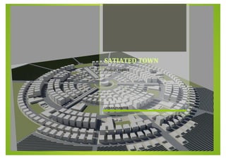
 3.0 Master Plan - Master plan description Our master plan consists of a centralised composition with 6 neighbourhoods that are linked together with a ring road that carry the main transportation line in addition to the main traffic circulation. We've chosen the centralized shape to achieve social cultural equity in the whole town, as shown in the figure below. Neighbourhood Number 2, 5 This neighbourhood accommodate 5435 inhabitant (35 inhabitant in low density housing units, 1800 inhabitant in medium density housing units, 3600 inhabitant in high density housing units), with 4 educational facilities (2 schools, 2 day care), 1 library, 1 health care clinic, and 1 police kiosk.
  • 15. Urban Planning Project SATIATED TOWN Neighbourhood Number 1, 6 This neighbourhood accommodate 6280 inhabitant (130 inhabitant in low density housing units, 1800 inhabitant in medium density housing units, 4350 inhabitant in high density housing units), with 4 educational facilities (3 schools, 1 day care), 1 health care clinic, and 1 police kiosk. Neighbourhood Number 3, 4 This neighbourhood accommodate 2950 inhabitant (50 inhabitant in low density housing units, 650 inhabitant in medium density housing units, 2250 inhabitant in high density housing units), with 2 educational facilities (1 school, 1 day care), 1 health care clinic, and 1 police kiosk.
  • 16. Urban Planning Project SATIATED TOWN 0 5 10 15 20 25 30 35 40 45 percentage segmentations 4.0 Design Guidelines - Attribution and Densities The land use plan has been strategically designed to accommodate larger agriculture land in a high density core area. Lower density residential areas are located in the central area and around the agricultural areas. Specifying the land use in the site that includes these segmentations and facilities: - Residential - Agriculture - Open spaces - Educational - Commercial - Health care - Cultural facilities - Security and public safety - Streets  The percentage of each segment and their areas in the project: As for the types of the residential sector, It includes 3 types according the density of the user: - High Density Buildings 39 % - Medium Density Buildings 47 % - Low Density Buildings 14 % The 3 building types are distributed on the site, as follows:  High density buildings = 139 plots  Medium Density buildings = 167 plots  Low density buildings = 49 plots Segmentations Percentage Area Residential Agriculture Open spaces Educational Commercial Health care Cultural facilities Security and public safety Streets 25 % 45 % 1.47 % 3.6 % 3.6 % 0.5 % 0.4 % 25 % 20 % 357 dunam 675 dunam 22.05 dunam 54 dunam 54 dunam 7.5 dunam 6 dunam 375 dunam 300 dunam
  • 17. Urban Planning Project SATIATED TOWN - Standards The total residents for the project = 29 625 The total residents needed is 30 000 person, we have a lack of 375 person, to m obtain the needed density we added 2 high density buildings which hold 300 person, and the rest 75 person will be added as the worker’s families with 15 m residual unit . The high density building’s attribution as follows:  mThe building is consisted of 10 storeys, each storey includes 3 apartments and each apartment holds 5 people.  Where there are 15 residential units in each building 150 person for the whole building.  The high density buildings hold in total 139 * 150 = 20850 person. The medium density building’s attribution as follows:  The building is consisted of 5 storeys, each storey includes 2 apartments and each apartment holds 5 people.   This means 10 units with 50 people for the whole building. The medium density building holds in total 167 * 50 = 8350 person
  • 18. Urban Planning Project SATIATED TOWN The low density buildings have two types: 1. Attached villas 10 % 2. Detached villas 4 % 1. Type one: (Attached villas)  This type of villas has 2 floors and each villa has 5 people  The number of this villa type is 35 plots on the site This means it holds in total 35 * 10 = 350 person 2. Type two: (Detached villas)  This type of villas is privately owned and includes 5 person  The number of this villa type is 14 plots on the site This means it holds in a total of 14 * 5 = 70 persons
  • 19. Urban Planning Project SATIATED TOWN Facilities Area Educational 60 dunam Day care 6 dunam schools 54 dunam Commercial & open space 26.5 dunam Mall 4 dunam Commercial strip 22.5 dunam Cultural facilities 44 dunam Cultural center 24 dunam Club house 20 dunam Health care 10.5 dunam Health care center 7.5 dunam Medical Clinic 3 dunam Security & public safety 3.4 dunam Police department 1 dunam Police kiosk 1.2 dunam Fire department 1.2 dunam Total 94.4 dunam
  • 20. Urban Planning Project SATIATED TOWN Done By Basil Basbous Mohammad Ateyat Razan Shalabi Shaha Maiteh Tamara Ta’amneh