Download to read offline

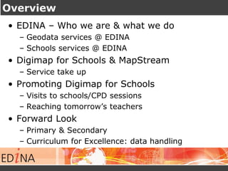


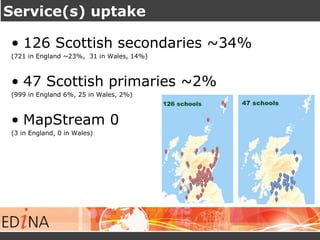
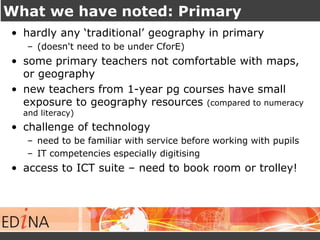
![Spatial analysis within Digimap for Schools
[While not a GIS…] Digimap for Schools provides spatial analysis
techniques such as buffering, presentation of data & data overlay](https://image.slidesharecdn.com/rsgsoct2014-141110055138-conversion-gate01/85/Geography-GIS-in-Scottish-Schools-Observations-from-a-Service-Provider-19-320.jpg)

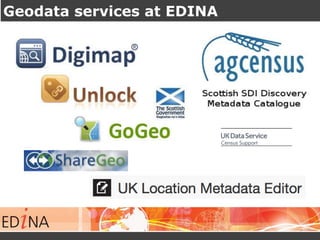
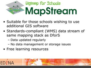
![What we have noted: Secondary
• Merger of Geography into Social Studies Dept
– Department head may be teacher of history/ modern studies
– lone geography teacher may not get support
• Limited time to plan how to integrate it into lessons
– prescriptive lesson plan / wish to know how other use DforS
• Technology / IT Challenge, e.g. digitising
• Access to ICT – need to book rooms or trolley
• [MapStream - don’t get it]](https://image.slidesharecdn.com/rsgsoct2014-141110055138-conversion-gate01/85/Geography-GIS-in-Scottish-Schools-Observations-from-a-Service-Provider-26-320.jpg)

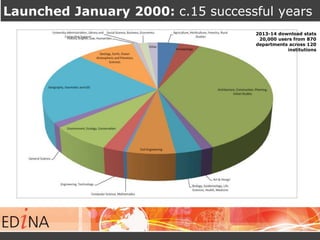
The document presents observations on the integration of geography and GIS within Scottish schools, highlighting the services provided by EDINA, particularly the Digimap for Schools. It reports on the uptake of these services in primary and secondary schools, discusses the promotion efforts, and outlines the curriculum relevance and experiences facilitated by these geographic tools. Challenges identified include limited geography education in primary schools and technology access issues in secondary schools, but there is a noted increase in engagement and demand for advanced spatial techniques.


