SlideShare a Scribd company logo
Rolta Aerial
Triangulation
Rolta Automatic
Elevation (A)
Rolta Ortho
Production (A)
Rolta Satellite
Triangulation
Rolta Automatic
Elevation (S)
Rolta Ortho
Production (S)
Rolta
Rolta Model
Rolta 2D
Rolta Raster Rolta Image
Photogrammetry
Setup
Feature
Manager UtilityManager Collection
Rolta
Photogrammetry
Nucleus
Rolta DTM Rolta 3D Feature
Collection Collection
Rolta Photogrammetry Suite
Rolta Photogrammetry suite is an end to end photogrammetry solution providing a versatile collection of software tools to produce
reliable geospatial data sets with the highest accuracy. The modular configuration of this program makes it an easy to use, accurate and
cost-effective in a production oriented environment. It addresses the entire range of photogrammetric techniques along with added
imaging applications to produce quality geospatial products. The products are technically supported by experienced domain experts.
Wide range of data format support
Rolta Photogrammetry Suite supports a wide range of data
formats starting from aerial frame cameras to recent digital aerial
cameras and digital satellite imageries.
Data Interoperability
Data interoperability is considered to be an essential functionality
in any photogrammetry solution, therefore, it is considered to be
a value add to the programme. It increases the usability of the
software in terms of its capability of producing outputs by
consuming different data, processed or unprocessed, available
from other sources.
Rolta Photogrammetry Suite accepts exterior orientation
parameters from a variety of formats and process data thereafter
in its own workflow to produce desired outputs
Quality Outputs
Rolta Photogrammetry Suite encompasses the complete
spectrum of photogrammetric measurements and hence
produces various outputs at different stages. It creates on- the-fly
epipolars, physical epipolars; generates raster and vector terrain
models and also produces various by product of these outputs like
contours, shaded reliefs and so on. It also produces orthorectified
images and combines adjacent rectified image to produce ortho-
mosaics.
Powerful Stereo Capture and Analysis
This programme provides different tools to visualize terrain in 3D
in its different modules. It allows overlay of terrain features, DEM
points on stereo models and also enables editing features in real
time. In addition to this its lets user to capture and edit different
image feature in 3Dmode.
“Rolta Photogrammetry Suite - Simplifying Mapping”
Stereo Visualization
Aerial Rolta
Suite
Satellite
Rolta Photogrammetry Suite ProductArchitecture
Rolta Photogrammetry Suite
Simplified yet powerful workflow
It’s scientifically designed, yet easy to learn workflow that let the
user to comprehend the photogrammetric process and to follow
the step by step workflow to obtain highly accurate throughputs.
This programme offers
Easy project set up
Easy Project editing
Fast data ingestion
Fast & accurate data processing
Powerful data storage & management
Specialized mapping applications & editingtools
Key Features
Provides versatile, accurate and cost-effective production
workflow oriented image analysis and Geospatial imaging
Automatic and manual inner orientation of aerial datasets
Automatic tie point and Auto GCP collection
On the fly and Physical epi-polar generation in satellite
triangulation
Abstracts the complexity of the entire data lifecycle across Data
Exploitation, Data Creation and Data Distribution.
Automatic Raster DEM creation and editing capability
Vector terrain data generation and editing
Provides data management tools required for production
workflow and increased flexibility in project management
through the inbuilt Project Management Tool.
DEM and Ortho generation of user definedarea
Exclude area option during DEM generation
Stereo Visualization and editing features instereo
High level of usability and accuracy through support by
experienced domain experts.
Benefits
Monoscopic, Semi-automatic correlation basis and Stereo Point
measurement options are made available for the ease of the
user while triangulating aerialdata
Support to several third-party block adjustment packages
through import export tool in aerial triangulation strengthening
interoperability
Statistical blunder indicators with enabled editing option for
user ensuring precise adjustment
Both Raster and Vector elevation data generation and editing
capability for highly accurate throughput generation
Powerful Ortho-image creation for small jobs interactively or
large jobs in batch mode fulfilling production demands at any
scale
Dynamic Image enhancement ensuring precise point
measurement and data collection during both triangulation and
mapping
Rolta Photogrammetry Suite is now available with an imaging tool called Rolta Image
Manager. This will facilitate user to perform different raster and vector operations as
well as provide raster DEM editing options for achieving greater accuracy with finer
details.

More Related Content

What's hot

Icaros Photogrammetric Suite (IPS) Module Overview
Icaros Photogrammetric Suite (IPS) Module OverviewIcaros Photogrammetric Suite (IPS) Module Overview
Icaros Photogrammetric Suite (IPS) Module Overview
IcarosMapping
 
Icaros Photogrammetric Suite (IPS) Workflow
Icaros Photogrammetric Suite (IPS) WorkflowIcaros Photogrammetric Suite (IPS) Workflow
Icaros Photogrammetric Suite (IPS) Workflow
IcarosMapping
 
Erdas image analysis for arcgis
Erdas   image analysis for arcgisErdas   image analysis for arcgis
Erdas image analysis for arcgis
César Martín Suárez Suárez
 
Mobile Options for ArcGIS – Selecting Your Solution
Mobile Options for ArcGIS – Selecting Your SolutionMobile Options for ArcGIS – Selecting Your Solution
Mobile Options for ArcGIS – Selecting Your Solution
WV Assocation of Geospatial Professionals
 
Field Activity Planner - A cloud based digital energy platform
Field Activity Planner - A cloud based digital energy platformField Activity Planner - A cloud based digital energy platform
Field Activity Planner - A cloud based digital energy platform
FutureOn
 
Webinar 2 - IMU & GPS
Webinar 2 - IMU & GPSWebinar 2 - IMU & GPS
Webinar 2 - IMU & GPS
Civil Maps
 
MVS Product Catalog
MVS Product CatalogMVS Product Catalog
MVS Product Catalog
Mike Camp
 
Poster Presentation "Generation of High Resolution DSM Usin UAV Images"
Poster Presentation "Generation of High Resolution DSM Usin UAV Images"Poster Presentation "Generation of High Resolution DSM Usin UAV Images"
Poster Presentation "Generation of High Resolution DSM Usin UAV Images"
Nepal Flying Labs
 
25 Years of GRASS GIS
25 Years of GRASS GIS25 Years of GRASS GIS
25 Years of GRASS GIS
Markus Neteler
 
Total station
Total stationTotal station
Total station
Sumit Jha
 
High resolution dem dtm
High resolution dem dtmHigh resolution dem dtm
High resolution dem dtm
TTI Production
 
Generation of High Resolution DSM using UAV Images - Final Year Project
Generation of High Resolution DSM using UAV Images - Final Year ProjectGeneration of High Resolution DSM using UAV Images - Final Year Project
Generation of High Resolution DSM using UAV Images - Final Year Project
Biplov Bhandari
 
Automated change detection in grass gis
Automated change detection in grass gisAutomated change detection in grass gis
Automated change detection in grass gis
COGS Presentations
 
Hack2o Facilities Mapping
Hack2o Facilities MappingHack2o Facilities Mapping
Hack2o Facilities Mapping
Ann Treacy
 
Leica GG04 and ZRover
Leica GG04 and ZRoverLeica GG04 and ZRover
Leica GG04 and ZRover
Kendall James
 
DSM Generation Using High Resolution UAV Images
DSM Generation Using High Resolution UAV ImagesDSM Generation Using High Resolution UAV Images
DSM Generation Using High Resolution UAV Images
Biplov Bhandari
 

What's hot (16)

Icaros Photogrammetric Suite (IPS) Module Overview
Icaros Photogrammetric Suite (IPS) Module OverviewIcaros Photogrammetric Suite (IPS) Module Overview
Icaros Photogrammetric Suite (IPS) Module Overview
 
Icaros Photogrammetric Suite (IPS) Workflow
Icaros Photogrammetric Suite (IPS) WorkflowIcaros Photogrammetric Suite (IPS) Workflow
Icaros Photogrammetric Suite (IPS) Workflow
 
Erdas image analysis for arcgis
Erdas   image analysis for arcgisErdas   image analysis for arcgis
Erdas image analysis for arcgis
 
Mobile Options for ArcGIS – Selecting Your Solution
Mobile Options for ArcGIS – Selecting Your SolutionMobile Options for ArcGIS – Selecting Your Solution
Mobile Options for ArcGIS – Selecting Your Solution
 
Field Activity Planner - A cloud based digital energy platform
Field Activity Planner - A cloud based digital energy platformField Activity Planner - A cloud based digital energy platform
Field Activity Planner - A cloud based digital energy platform
 
Webinar 2 - IMU & GPS
Webinar 2 - IMU & GPSWebinar 2 - IMU & GPS
Webinar 2 - IMU & GPS
 
MVS Product Catalog
MVS Product CatalogMVS Product Catalog
MVS Product Catalog
 
Poster Presentation "Generation of High Resolution DSM Usin UAV Images"
Poster Presentation "Generation of High Resolution DSM Usin UAV Images"Poster Presentation "Generation of High Resolution DSM Usin UAV Images"
Poster Presentation "Generation of High Resolution DSM Usin UAV Images"
 
25 Years of GRASS GIS
25 Years of GRASS GIS25 Years of GRASS GIS
25 Years of GRASS GIS
 
Total station
Total stationTotal station
Total station
 
High resolution dem dtm
High resolution dem dtmHigh resolution dem dtm
High resolution dem dtm
 
Generation of High Resolution DSM using UAV Images - Final Year Project
Generation of High Resolution DSM using UAV Images - Final Year ProjectGeneration of High Resolution DSM using UAV Images - Final Year Project
Generation of High Resolution DSM using UAV Images - Final Year Project
 
Automated change detection in grass gis
Automated change detection in grass gisAutomated change detection in grass gis
Automated change detection in grass gis
 
Hack2o Facilities Mapping
Hack2o Facilities MappingHack2o Facilities Mapping
Hack2o Facilities Mapping
 
Leica GG04 and ZRover
Leica GG04 and ZRoverLeica GG04 and ZRover
Leica GG04 and ZRover
 
DSM Generation Using High Resolution UAV Images
DSM Generation Using High Resolution UAV ImagesDSM Generation Using High Resolution UAV Images
DSM Generation Using High Resolution UAV Images
 

Similar to Rolta Photogrammetry Suite

Rolta Geomatica Suite
Rolta Geomatica SuiteRolta Geomatica Suite
Rolta Geomatica Suite
Rolta
 
IRJET- Proposed Design for 3D Map Generation using UAV
IRJET- Proposed Design for 3D Map Generation using UAVIRJET- Proposed Design for 3D Map Generation using UAV
IRJET- Proposed Design for 3D Map Generation using UAV
IRJET Journal
 
Generating higher accuracy digital data products by model parameter
Generating higher accuracy digital data products by model parameterGenerating higher accuracy digital data products by model parameter
Generating higher accuracy digital data products by model parameter
IAEME Publication
 
Accuracy checks in the production of orthophotos
Accuracy checks in the production of orthophotosAccuracy checks in the production of orthophotos
Accuracy checks in the production of orthophotos
Alexander Decker
 
Desktop Softwares for Unmanned Aerial Systems(UAS))
Desktop Softwares for Unmanned Aerial Systems(UAS))Desktop Softwares for Unmanned Aerial Systems(UAS))
Desktop Softwares for Unmanned Aerial Systems(UAS))
Kamal Shahi
 
Geospatial Product Watch 2015
Geospatial Product Watch 2015Geospatial Product Watch 2015
Geospatial Product Watch 2015
Geospatial Media & Communications
 
Laser Navigation product - Introduction -
Laser Navigation product - Introduction -Laser Navigation product - Introduction -
Laser Navigation product - Introduction -
Roberto Navoni
 
Presentazione Wireless Forum 08
Presentazione Wireless Forum 08Presentazione Wireless Forum 08
Presentazione Wireless Forum 08
Roberto Navoni
 
Satpalda Services
Satpalda ServicesSatpalda Services
Satpalda Services
Rajneesh Mohan Singh
 
Catalogue 2019 Presagis
Catalogue 2019 PresagisCatalogue 2019 Presagis
Catalogue 2019 Presagis
Presagis
 
MIDIH Research Studio-AWEAR experiment
MIDIH Research Studio-AWEAR experimentMIDIH Research Studio-AWEAR experiment
MIDIH Research Studio-AWEAR experiment
MIDIH_EU
 
Arindam batabyal literature reviewpresentation
Arindam batabyal literature reviewpresentationArindam batabyal literature reviewpresentation
Arindam batabyal literature reviewpresentation
Arindam Batabyal
 
Mitchell Reifel (pmdtechnologies ag): pmd Time-of-Flight – the Swiss Army Kni...
Mitchell Reifel (pmdtechnologies ag): pmd Time-of-Flight – the Swiss Army Kni...Mitchell Reifel (pmdtechnologies ag): pmd Time-of-Flight – the Swiss Army Kni...
Mitchell Reifel (pmdtechnologies ag): pmd Time-of-Flight – the Swiss Army Kni...
AugmentedWorldExpo
 
IRJET-Implementation of Image Processing using Augmented Reality
IRJET-Implementation of Image Processing using Augmented RealityIRJET-Implementation of Image Processing using Augmented Reality
IRJET-Implementation of Image Processing using Augmented Reality
IRJET Journal
 
Satsoft brochure
Satsoft brochureSatsoft brochure
IRJET- Profile Management System
IRJET- Profile Management SystemIRJET- Profile Management System
IRJET- Profile Management System
IRJET Journal
 
Digital photogrammetry software.pptx
Digital photogrammetry software.pptxDigital photogrammetry software.pptx
Digital photogrammetry software.pptx
RAJKUMARPOREL
 
GWT 2014: Energy Conference - 01 Introduzione
GWT 2014: Energy Conference - 01 IntroduzioneGWT 2014: Energy Conference - 01 Introduzione
GWT 2014: Energy Conference - 01 Introduzione
Planetek Italia Srl
 
Mobile CDS LTE Simulation Demo
Mobile CDS LTE Simulation Demo Mobile CDS LTE Simulation Demo
Mobile CDS LTE Simulation Demo
Dr. Edwin Hernandez
 
What’s New in eCognition 8.9
What’s New in eCognition 8.9What’s New in eCognition 8.9
What’s New in eCognition 8.9
Trimble Geospatial Munich
 

Similar to Rolta Photogrammetry Suite (20)

Rolta Geomatica Suite
Rolta Geomatica SuiteRolta Geomatica Suite
Rolta Geomatica Suite
 
IRJET- Proposed Design for 3D Map Generation using UAV
IRJET- Proposed Design for 3D Map Generation using UAVIRJET- Proposed Design for 3D Map Generation using UAV
IRJET- Proposed Design for 3D Map Generation using UAV
 
Generating higher accuracy digital data products by model parameter
Generating higher accuracy digital data products by model parameterGenerating higher accuracy digital data products by model parameter
Generating higher accuracy digital data products by model parameter
 
Accuracy checks in the production of orthophotos
Accuracy checks in the production of orthophotosAccuracy checks in the production of orthophotos
Accuracy checks in the production of orthophotos
 
Desktop Softwares for Unmanned Aerial Systems(UAS))
Desktop Softwares for Unmanned Aerial Systems(UAS))Desktop Softwares for Unmanned Aerial Systems(UAS))
Desktop Softwares for Unmanned Aerial Systems(UAS))
 
Geospatial Product Watch 2015
Geospatial Product Watch 2015Geospatial Product Watch 2015
Geospatial Product Watch 2015
 
Laser Navigation product - Introduction -
Laser Navigation product - Introduction -Laser Navigation product - Introduction -
Laser Navigation product - Introduction -
 
Presentazione Wireless Forum 08
Presentazione Wireless Forum 08Presentazione Wireless Forum 08
Presentazione Wireless Forum 08
 
Satpalda Services
Satpalda ServicesSatpalda Services
Satpalda Services
 
Catalogue 2019 Presagis
Catalogue 2019 PresagisCatalogue 2019 Presagis
Catalogue 2019 Presagis
 
MIDIH Research Studio-AWEAR experiment
MIDIH Research Studio-AWEAR experimentMIDIH Research Studio-AWEAR experiment
MIDIH Research Studio-AWEAR experiment
 
Arindam batabyal literature reviewpresentation
Arindam batabyal literature reviewpresentationArindam batabyal literature reviewpresentation
Arindam batabyal literature reviewpresentation
 
Mitchell Reifel (pmdtechnologies ag): pmd Time-of-Flight – the Swiss Army Kni...
Mitchell Reifel (pmdtechnologies ag): pmd Time-of-Flight – the Swiss Army Kni...Mitchell Reifel (pmdtechnologies ag): pmd Time-of-Flight – the Swiss Army Kni...
Mitchell Reifel (pmdtechnologies ag): pmd Time-of-Flight – the Swiss Army Kni...
 
IRJET-Implementation of Image Processing using Augmented Reality
IRJET-Implementation of Image Processing using Augmented RealityIRJET-Implementation of Image Processing using Augmented Reality
IRJET-Implementation of Image Processing using Augmented Reality
 
Satsoft brochure
Satsoft brochureSatsoft brochure
Satsoft brochure
 
IRJET- Profile Management System
IRJET- Profile Management SystemIRJET- Profile Management System
IRJET- Profile Management System
 
Digital photogrammetry software.pptx
Digital photogrammetry software.pptxDigital photogrammetry software.pptx
Digital photogrammetry software.pptx
 
GWT 2014: Energy Conference - 01 Introduzione
GWT 2014: Energy Conference - 01 IntroduzioneGWT 2014: Energy Conference - 01 Introduzione
GWT 2014: Energy Conference - 01 Introduzione
 
Mobile CDS LTE Simulation Demo
Mobile CDS LTE Simulation Demo Mobile CDS LTE Simulation Demo
Mobile CDS LTE Simulation Demo
 
What’s New in eCognition 8.9
What’s New in eCognition 8.9What’s New in eCognition 8.9
What’s New in eCognition 8.9
 

More from Rolta

Rolta OneView™
Rolta OneView™Rolta OneView™
Rolta OneView™
Rolta
 
What's new in OnPoint 7.5
What's new in OnPoint 7.5What's new in OnPoint 7.5
What's new in OnPoint 7.5
Rolta
 
Rolta Advanced GIS Tool
Rolta Advanced GIS Tool Rolta Advanced GIS Tool
Rolta Advanced GIS Tool
Rolta
 
What's new in Rolta OnPoint 8.5
What's new in Rolta OnPoint 8.5What's new in Rolta OnPoint 8.5
What's new in Rolta OnPoint 8.5
Rolta
 
Rolta Terrain Analyst for software terrain manipulation.
Rolta Terrain Analyst for software terrain manipulation.Rolta Terrain Analyst for software terrain manipulation.
Rolta Terrain Analyst for software terrain manipulation.
Rolta
 
Rolta Tactical Decision Support System for advanced GIS solutions
Rolta Tactical Decision Support System for advanced GIS solutionsRolta Tactical Decision Support System for advanced GIS solutions
Rolta Tactical Decision Support System for advanced GIS solutions
Rolta
 
Rolta Software for Walkthrough for terrain visual analysis
Rolta Software for Walkthrough for terrain visual analysisRolta Software for Walkthrough for terrain visual analysis
Rolta Software for Walkthrough for terrain visual analysis
Rolta
 
Situational Awareness System by Rolta
Situational Awareness System by RoltaSituational Awareness System by Rolta
Situational Awareness System by Rolta
Rolta
 
ROLTA Photogrammetry Suite
ROLTA Photogrammetry SuiteROLTA Photogrammetry Suite
ROLTA Photogrammetry Suite
Rolta
 
Rolta Geoimaging Suite for high performance.
Rolta Geoimaging Suite for high performance.Rolta Geoimaging Suite for high performance.
Rolta Geoimaging Suite for high performance.
Rolta
 
Night Vision scopes by Rolta
Night Vision scopes by RoltaNight Vision scopes by Rolta
Night Vision scopes by Rolta
Rolta
 
Rolta Terrain Analytics for accurate terrain analysis
Rolta Terrain Analytics for accurate terrain analysisRolta Terrain Analytics for accurate terrain analysis
Rolta Terrain Analytics for accurate terrain analysis
Rolta
 
Rolta Mine Field Recording System
Rolta Mine Field Recording SystemRolta Mine Field Recording System
Rolta Mine Field Recording System
Rolta
 
Rolta IRS Sensor distortion handling
Rolta IRS Sensor distortion handling  Rolta IRS Sensor distortion handling
Rolta IRS Sensor distortion handling
Rolta
 
eGovernance - Geospatial Fusion Rolta
eGovernance - Geospatial Fusion Rolta eGovernance - Geospatial Fusion Rolta
eGovernance - Geospatial Fusion Rolta
Rolta
 
Enterprise performance management by Rolta for better and faster decisions
Enterprise performance management by Rolta for better and faster decisionsEnterprise performance management by Rolta for better and faster decisions
Enterprise performance management by Rolta for better and faster decisions
Rolta
 
Data warehousing by Rolta Exdata for Extreme Performance Extreme Service
Data warehousing by Rolta Exdata for Extreme Performance Extreme ServiceData warehousing by Rolta Exdata for Extreme Performance Extreme Service
Data warehousing by Rolta Exdata for Extreme Performance Extreme Service
Rolta
 
Enterprise performance management by Rolta for better and faster decisions
Enterprise performance management by Rolta for better and faster decisions Enterprise performance management by Rolta for better and faster decisions
Enterprise performance management by Rolta for better and faster decisions
Rolta
 
Rolta Enterprise GIS portal for terrain virtualization and secure internet en...
Rolta Enterprise GIS portal for terrain virtualization and secure internet en...Rolta Enterprise GIS portal for terrain virtualization and secure internet en...
Rolta Enterprise GIS portal for terrain virtualization and secure internet en...
Rolta
 
Rolta’s collection of Digital Tarrin Model (DTM)
Rolta’s collection of Digital Tarrin Model (DTM)Rolta’s collection of Digital Tarrin Model (DTM)
Rolta’s collection of Digital Tarrin Model (DTM)
Rolta
 

More from Rolta (20)

Rolta OneView™
Rolta OneView™Rolta OneView™
Rolta OneView™
 
What's new in OnPoint 7.5
What's new in OnPoint 7.5What's new in OnPoint 7.5
What's new in OnPoint 7.5
 
Rolta Advanced GIS Tool
Rolta Advanced GIS Tool Rolta Advanced GIS Tool
Rolta Advanced GIS Tool
 
What's new in Rolta OnPoint 8.5
What's new in Rolta OnPoint 8.5What's new in Rolta OnPoint 8.5
What's new in Rolta OnPoint 8.5
 
Rolta Terrain Analyst for software terrain manipulation.
Rolta Terrain Analyst for software terrain manipulation.Rolta Terrain Analyst for software terrain manipulation.
Rolta Terrain Analyst for software terrain manipulation.
 
Rolta Tactical Decision Support System for advanced GIS solutions
Rolta Tactical Decision Support System for advanced GIS solutionsRolta Tactical Decision Support System for advanced GIS solutions
Rolta Tactical Decision Support System for advanced GIS solutions
 
Rolta Software for Walkthrough for terrain visual analysis
Rolta Software for Walkthrough for terrain visual analysisRolta Software for Walkthrough for terrain visual analysis
Rolta Software for Walkthrough for terrain visual analysis
 
Situational Awareness System by Rolta
Situational Awareness System by RoltaSituational Awareness System by Rolta
Situational Awareness System by Rolta
 
ROLTA Photogrammetry Suite
ROLTA Photogrammetry SuiteROLTA Photogrammetry Suite
ROLTA Photogrammetry Suite
 
Rolta Geoimaging Suite for high performance.
Rolta Geoimaging Suite for high performance.Rolta Geoimaging Suite for high performance.
Rolta Geoimaging Suite for high performance.
 
Night Vision scopes by Rolta
Night Vision scopes by RoltaNight Vision scopes by Rolta
Night Vision scopes by Rolta
 
Rolta Terrain Analytics for accurate terrain analysis
Rolta Terrain Analytics for accurate terrain analysisRolta Terrain Analytics for accurate terrain analysis
Rolta Terrain Analytics for accurate terrain analysis
 
Rolta Mine Field Recording System
Rolta Mine Field Recording SystemRolta Mine Field Recording System
Rolta Mine Field Recording System
 
Rolta IRS Sensor distortion handling
Rolta IRS Sensor distortion handling  Rolta IRS Sensor distortion handling
Rolta IRS Sensor distortion handling
 
eGovernance - Geospatial Fusion Rolta
eGovernance - Geospatial Fusion Rolta eGovernance - Geospatial Fusion Rolta
eGovernance - Geospatial Fusion Rolta
 
Enterprise performance management by Rolta for better and faster decisions
Enterprise performance management by Rolta for better and faster decisionsEnterprise performance management by Rolta for better and faster decisions
Enterprise performance management by Rolta for better and faster decisions
 
Data warehousing by Rolta Exdata for Extreme Performance Extreme Service
Data warehousing by Rolta Exdata for Extreme Performance Extreme ServiceData warehousing by Rolta Exdata for Extreme Performance Extreme Service
Data warehousing by Rolta Exdata for Extreme Performance Extreme Service
 
Enterprise performance management by Rolta for better and faster decisions
Enterprise performance management by Rolta for better and faster decisions Enterprise performance management by Rolta for better and faster decisions
Enterprise performance management by Rolta for better and faster decisions
 
Rolta Enterprise GIS portal for terrain virtualization and secure internet en...
Rolta Enterprise GIS portal for terrain virtualization and secure internet en...Rolta Enterprise GIS portal for terrain virtualization and secure internet en...
Rolta Enterprise GIS portal for terrain virtualization and secure internet en...
 
Rolta’s collection of Digital Tarrin Model (DTM)
Rolta’s collection of Digital Tarrin Model (DTM)Rolta’s collection of Digital Tarrin Model (DTM)
Rolta’s collection of Digital Tarrin Model (DTM)
 

Recently uploaded

Introduction to CHERI technology - Cybersecurity
Introduction to CHERI technology - CybersecurityIntroduction to CHERI technology - Cybersecurity
Introduction to CHERI technology - Cybersecurity
mikeeftimakis1
 
GraphSummit Singapore | Enhancing Changi Airport Group's Passenger Experience...
GraphSummit Singapore | Enhancing Changi Airport Group's Passenger Experience...GraphSummit Singapore | Enhancing Changi Airport Group's Passenger Experience...
GraphSummit Singapore | Enhancing Changi Airport Group's Passenger Experience...
Neo4j
 
PCI PIN Basics Webinar from the Controlcase Team
PCI PIN Basics Webinar from the Controlcase TeamPCI PIN Basics Webinar from the Controlcase Team
PCI PIN Basics Webinar from the Controlcase Team
ControlCase
 
How to Get CNIC Information System with Paksim Ga.pptx
How to Get CNIC Information System with Paksim Ga.pptxHow to Get CNIC Information System with Paksim Ga.pptx
How to Get CNIC Information System with Paksim Ga.pptx
danishmna97
 
20 Comprehensive Checklist of Designing and Developing a Website
20 Comprehensive Checklist of Designing and Developing a Website20 Comprehensive Checklist of Designing and Developing a Website
20 Comprehensive Checklist of Designing and Developing a Website
Pixlogix Infotech
 
Securing your Kubernetes cluster_ a step-by-step guide to success !
Securing your Kubernetes cluster_ a step-by-step guide to success !Securing your Kubernetes cluster_ a step-by-step guide to success !
Securing your Kubernetes cluster_ a step-by-step guide to success !
KatiaHIMEUR1
 
Unlock the Future of Search with MongoDB Atlas_ Vector Search Unleashed.pdf
Unlock the Future of Search with MongoDB Atlas_ Vector Search Unleashed.pdfUnlock the Future of Search with MongoDB Atlas_ Vector Search Unleashed.pdf
Unlock the Future of Search with MongoDB Atlas_ Vector Search Unleashed.pdf
Malak Abu Hammad
 
How to use Firebase Data Connect For Flutter
How to use Firebase Data Connect For FlutterHow to use Firebase Data Connect For Flutter
How to use Firebase Data Connect For Flutter
Daiki Mogmet Ito
 
Communications Mining Series - Zero to Hero - Session 1
Communications Mining Series - Zero to Hero - Session 1Communications Mining Series - Zero to Hero - Session 1
Communications Mining Series - Zero to Hero - Session 1
DianaGray10
 
GraphSummit Singapore | Neo4j Product Vision & Roadmap - Q2 2024
GraphSummit Singapore | Neo4j Product Vision & Roadmap - Q2 2024GraphSummit Singapore | Neo4j Product Vision & Roadmap - Q2 2024
GraphSummit Singapore | Neo4j Product Vision & Roadmap - Q2 2024
Neo4j
 
20240609 QFM020 Irresponsible AI Reading List May 2024
20240609 QFM020 Irresponsible AI Reading List May 202420240609 QFM020 Irresponsible AI Reading List May 2024
20240609 QFM020 Irresponsible AI Reading List May 2024
Matthew Sinclair
 
National Security Agency - NSA mobile device best practices
National Security Agency - NSA mobile device best practicesNational Security Agency - NSA mobile device best practices
National Security Agency - NSA mobile device best practices
Quotidiano Piemontese
 
Full-RAG: A modern architecture for hyper-personalization
Full-RAG: A modern architecture for hyper-personalizationFull-RAG: A modern architecture for hyper-personalization
Full-RAG: A modern architecture for hyper-personalization
Zilliz
 
“I’m still / I’m still / Chaining from the Block”
“I’m still / I’m still / Chaining from the Block”“I’m still / I’m still / Chaining from the Block”
“I’m still / I’m still / Chaining from the Block”
Claudio Di Ciccio
 
Large Language Model (LLM) and it’s Geospatial Applications
Large Language Model (LLM) and it’s Geospatial ApplicationsLarge Language Model (LLM) and it’s Geospatial Applications
Large Language Model (LLM) and it’s Geospatial Applications
Rohit Gautam
 
“Building and Scaling AI Applications with the Nx AI Manager,” a Presentation...
“Building and Scaling AI Applications with the Nx AI Manager,” a Presentation...“Building and Scaling AI Applications with the Nx AI Manager,” a Presentation...
“Building and Scaling AI Applications with the Nx AI Manager,” a Presentation...
Edge AI and Vision Alliance
 
Cosa hanno in comune un mattoncino Lego e la backdoor XZ?
Cosa hanno in comune un mattoncino Lego e la backdoor XZ?Cosa hanno in comune un mattoncino Lego e la backdoor XZ?
Cosa hanno in comune un mattoncino Lego e la backdoor XZ?
Speck&Tech
 
Removing Uninteresting Bytes in Software Fuzzing
Removing Uninteresting Bytes in Software FuzzingRemoving Uninteresting Bytes in Software Fuzzing
Removing Uninteresting Bytes in Software Fuzzing
Aftab Hussain
 
Encryption in Microsoft 365 - ExpertsLive Netherlands 2024
Encryption in Microsoft 365 - ExpertsLive Netherlands 2024Encryption in Microsoft 365 - ExpertsLive Netherlands 2024
Encryption in Microsoft 365 - ExpertsLive Netherlands 2024
Albert Hoitingh
 
A tale of scale & speed: How the US Navy is enabling software delivery from l...
A tale of scale & speed: How the US Navy is enabling software delivery from l...A tale of scale & speed: How the US Navy is enabling software delivery from l...
A tale of scale & speed: How the US Navy is enabling software delivery from l...
sonjaschweigert1
 

Recently uploaded (20)

Introduction to CHERI technology - Cybersecurity
Introduction to CHERI technology - CybersecurityIntroduction to CHERI technology - Cybersecurity
Introduction to CHERI technology - Cybersecurity
 
GraphSummit Singapore | Enhancing Changi Airport Group's Passenger Experience...
GraphSummit Singapore | Enhancing Changi Airport Group's Passenger Experience...GraphSummit Singapore | Enhancing Changi Airport Group's Passenger Experience...
GraphSummit Singapore | Enhancing Changi Airport Group's Passenger Experience...
 
PCI PIN Basics Webinar from the Controlcase Team
PCI PIN Basics Webinar from the Controlcase TeamPCI PIN Basics Webinar from the Controlcase Team
PCI PIN Basics Webinar from the Controlcase Team
 
How to Get CNIC Information System with Paksim Ga.pptx
How to Get CNIC Information System with Paksim Ga.pptxHow to Get CNIC Information System with Paksim Ga.pptx
How to Get CNIC Information System with Paksim Ga.pptx
 
20 Comprehensive Checklist of Designing and Developing a Website
20 Comprehensive Checklist of Designing and Developing a Website20 Comprehensive Checklist of Designing and Developing a Website
20 Comprehensive Checklist of Designing and Developing a Website
 
Securing your Kubernetes cluster_ a step-by-step guide to success !
Securing your Kubernetes cluster_ a step-by-step guide to success !Securing your Kubernetes cluster_ a step-by-step guide to success !
Securing your Kubernetes cluster_ a step-by-step guide to success !
 
Unlock the Future of Search with MongoDB Atlas_ Vector Search Unleashed.pdf
Unlock the Future of Search with MongoDB Atlas_ Vector Search Unleashed.pdfUnlock the Future of Search with MongoDB Atlas_ Vector Search Unleashed.pdf
Unlock the Future of Search with MongoDB Atlas_ Vector Search Unleashed.pdf
 
How to use Firebase Data Connect For Flutter
How to use Firebase Data Connect For FlutterHow to use Firebase Data Connect For Flutter
How to use Firebase Data Connect For Flutter
 
Communications Mining Series - Zero to Hero - Session 1
Communications Mining Series - Zero to Hero - Session 1Communications Mining Series - Zero to Hero - Session 1
Communications Mining Series - Zero to Hero - Session 1
 
GraphSummit Singapore | Neo4j Product Vision & Roadmap - Q2 2024
GraphSummit Singapore | Neo4j Product Vision & Roadmap - Q2 2024GraphSummit Singapore | Neo4j Product Vision & Roadmap - Q2 2024
GraphSummit Singapore | Neo4j Product Vision & Roadmap - Q2 2024
 
20240609 QFM020 Irresponsible AI Reading List May 2024
20240609 QFM020 Irresponsible AI Reading List May 202420240609 QFM020 Irresponsible AI Reading List May 2024
20240609 QFM020 Irresponsible AI Reading List May 2024
 
National Security Agency - NSA mobile device best practices
National Security Agency - NSA mobile device best practicesNational Security Agency - NSA mobile device best practices
National Security Agency - NSA mobile device best practices
 
Full-RAG: A modern architecture for hyper-personalization
Full-RAG: A modern architecture for hyper-personalizationFull-RAG: A modern architecture for hyper-personalization
Full-RAG: A modern architecture for hyper-personalization
 
“I’m still / I’m still / Chaining from the Block”
“I’m still / I’m still / Chaining from the Block”“I’m still / I’m still / Chaining from the Block”
“I’m still / I’m still / Chaining from the Block”
 
Large Language Model (LLM) and it’s Geospatial Applications
Large Language Model (LLM) and it’s Geospatial ApplicationsLarge Language Model (LLM) and it’s Geospatial Applications
Large Language Model (LLM) and it’s Geospatial Applications
 
“Building and Scaling AI Applications with the Nx AI Manager,” a Presentation...
“Building and Scaling AI Applications with the Nx AI Manager,” a Presentation...“Building and Scaling AI Applications with the Nx AI Manager,” a Presentation...
“Building and Scaling AI Applications with the Nx AI Manager,” a Presentation...
 
Cosa hanno in comune un mattoncino Lego e la backdoor XZ?
Cosa hanno in comune un mattoncino Lego e la backdoor XZ?Cosa hanno in comune un mattoncino Lego e la backdoor XZ?
Cosa hanno in comune un mattoncino Lego e la backdoor XZ?
 
Removing Uninteresting Bytes in Software Fuzzing
Removing Uninteresting Bytes in Software FuzzingRemoving Uninteresting Bytes in Software Fuzzing
Removing Uninteresting Bytes in Software Fuzzing
 
Encryption in Microsoft 365 - ExpertsLive Netherlands 2024
Encryption in Microsoft 365 - ExpertsLive Netherlands 2024Encryption in Microsoft 365 - ExpertsLive Netherlands 2024
Encryption in Microsoft 365 - ExpertsLive Netherlands 2024
 
A tale of scale & speed: How the US Navy is enabling software delivery from l...
A tale of scale & speed: How the US Navy is enabling software delivery from l...A tale of scale & speed: How the US Navy is enabling software delivery from l...
A tale of scale & speed: How the US Navy is enabling software delivery from l...
 

Rolta Photogrammetry Suite

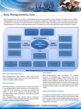
  • 1. Rolta Aerial Triangulation Rolta Automatic Elevation (A) Rolta Ortho Production (A) Rolta Satellite Triangulation Rolta Automatic Elevation (S) Rolta Ortho Production (S) Rolta Rolta Model Rolta 2D Rolta Raster Rolta Image Photogrammetry Setup Feature Manager UtilityManager Collection Rolta Photogrammetry Nucleus Rolta DTM Rolta 3D Feature Collection Collection Rolta Photogrammetry Suite Rolta Photogrammetry suite is an end to end photogrammetry solution providing a versatile collection of software tools to produce reliable geospatial data sets with the highest accuracy. The modular configuration of this program makes it an easy to use, accurate and cost-effective in a production oriented environment. It addresses the entire range of photogrammetric techniques along with added imaging applications to produce quality geospatial products. The products are technically supported by experienced domain experts. Wide range of data format support Rolta Photogrammetry Suite supports a wide range of data formats starting from aerial frame cameras to recent digital aerial cameras and digital satellite imageries. Data Interoperability Data interoperability is considered to be an essential functionality in any photogrammetry solution, therefore, it is considered to be a value add to the programme. It increases the usability of the software in terms of its capability of producing outputs by consuming different data, processed or unprocessed, available from other sources. Rolta Photogrammetry Suite accepts exterior orientation parameters from a variety of formats and process data thereafter in its own workflow to produce desired outputs Quality Outputs Rolta Photogrammetry Suite encompasses the complete spectrum of photogrammetric measurements and hence produces various outputs at different stages. It creates on- the-fly epipolars, physical epipolars; generates raster and vector terrain models and also produces various by product of these outputs like contours, shaded reliefs and so on. It also produces orthorectified images and combines adjacent rectified image to produce ortho- mosaics. Powerful Stereo Capture and Analysis This programme provides different tools to visualize terrain in 3D in its different modules. It allows overlay of terrain features, DEM points on stereo models and also enables editing features in real time. In addition to this its lets user to capture and edit different image feature in 3Dmode. “Rolta Photogrammetry Suite - Simplifying Mapping” Stereo Visualization Aerial Rolta Suite Satellite Rolta Photogrammetry Suite ProductArchitecture
  • 2. Rolta Photogrammetry Suite Simplified yet powerful workflow It’s scientifically designed, yet easy to learn workflow that let the user to comprehend the photogrammetric process and to follow the step by step workflow to obtain highly accurate throughputs. This programme offers Easy project set up Easy Project editing Fast data ingestion Fast & accurate data processing Powerful data storage & management Specialized mapping applications & editingtools Key Features Provides versatile, accurate and cost-effective production workflow oriented image analysis and Geospatial imaging Automatic and manual inner orientation of aerial datasets Automatic tie point and Auto GCP collection On the fly and Physical epi-polar generation in satellite triangulation Abstracts the complexity of the entire data lifecycle across Data Exploitation, Data Creation and Data Distribution. Automatic Raster DEM creation and editing capability Vector terrain data generation and editing Provides data management tools required for production workflow and increased flexibility in project management through the inbuilt Project Management Tool. DEM and Ortho generation of user definedarea Exclude area option during DEM generation Stereo Visualization and editing features instereo High level of usability and accuracy through support by experienced domain experts. Benefits Monoscopic, Semi-automatic correlation basis and Stereo Point measurement options are made available for the ease of the user while triangulating aerialdata Support to several third-party block adjustment packages through import export tool in aerial triangulation strengthening interoperability Statistical blunder indicators with enabled editing option for user ensuring precise adjustment Both Raster and Vector elevation data generation and editing capability for highly accurate throughput generation Powerful Ortho-image creation for small jobs interactively or large jobs in batch mode fulfilling production demands at any scale Dynamic Image enhancement ensuring precise point measurement and data collection during both triangulation and mapping Rolta Photogrammetry Suite is now available with an imaging tool called Rolta Image Manager. This will facilitate user to perform different raster and vector operations as well as provide raster DEM editing options for achieving greater accuracy with finer details.