Download as PDF, PPTX


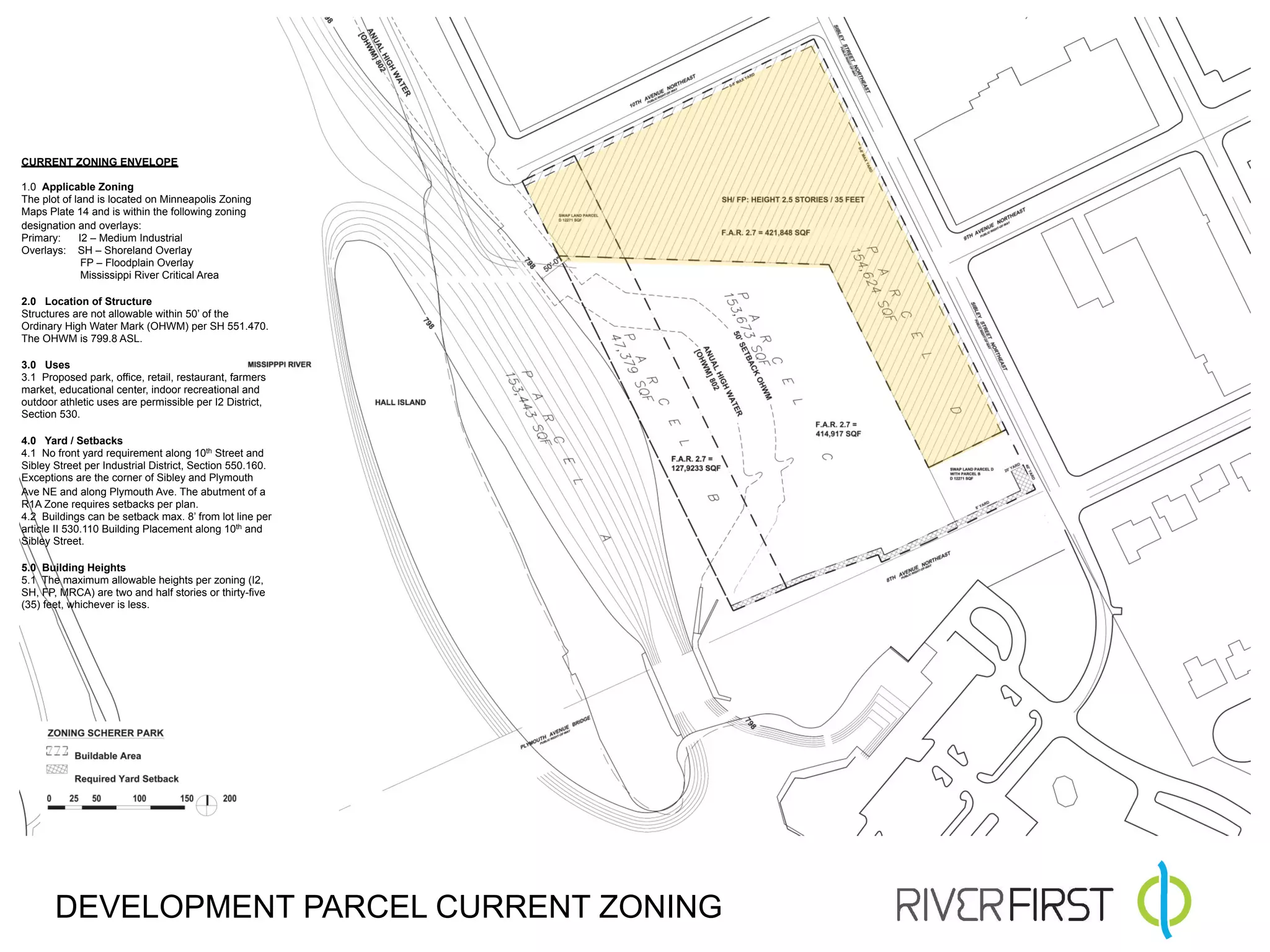
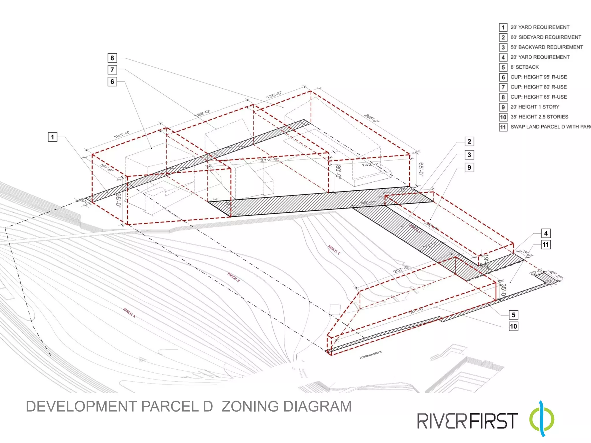
![PROPOSED ENVELOPE
1.0 Applicable Zoning
The plot of land is located on Minneapolis Zoning
Maps Plate 14 and is within the following zoning
designation and overlays:
Primary: I2 – Medium Industrial
Overlays: SH – Shoreland Overlay
FP – Floodplain Overlay
Mississippi River Critical Area
2.0 Location of Structure
Structures are not allowable within 50’ of the
Ordinary High Water Mark (OHWM) per SH 551.470.
The OHWM is 799.8 ASL.
3.0 Uses
3.1 Proposed park, office, retail, restaurant, farmers
market, educational center, indoor recreational and
outdoor athletic uses are permissible per I2 District,
Section 530.
3.1 Residential use in specified areas per CUP.
4.0 Yard / Setbacks
4.1 No front yard requirement along 10th Street and
Sibley Street per Industrial District, Section 550.160.
Exceptions are the corner of Sibley and Plymouth
Ave NE and along Plymouth Ave. The abutment of a
R1A Zone requires setbacks per plan.
4.2 Buildings can be setback max. 8’ from lot line per
article II 530.110 Building Placement along 10th and
Sibley Street.
4.3 Additional yards/setbacks requirements as
specified in drawing.
5.0 Building Heights
5.1 The maximum allowable heights per zoning (I2,
SH, FP, MRCA) are two and half stories or thirty-five
(35) feet, whichever is less.
5.2 The desired maximum allowable height per
drawing requires a conditional use permit [CUP]
per 550.140 (Increasing maximum height).
DEVELOPMENT PARCEL PROPOSED GUIDELINES](https://image.slidesharecdn.com/mprbriverfirstopenhousepresentation2013-01-17-130118165318-phpapp01/75/RiverFirst-Schematic-Design-Mid-term-Presentation-22-2048.jpg)
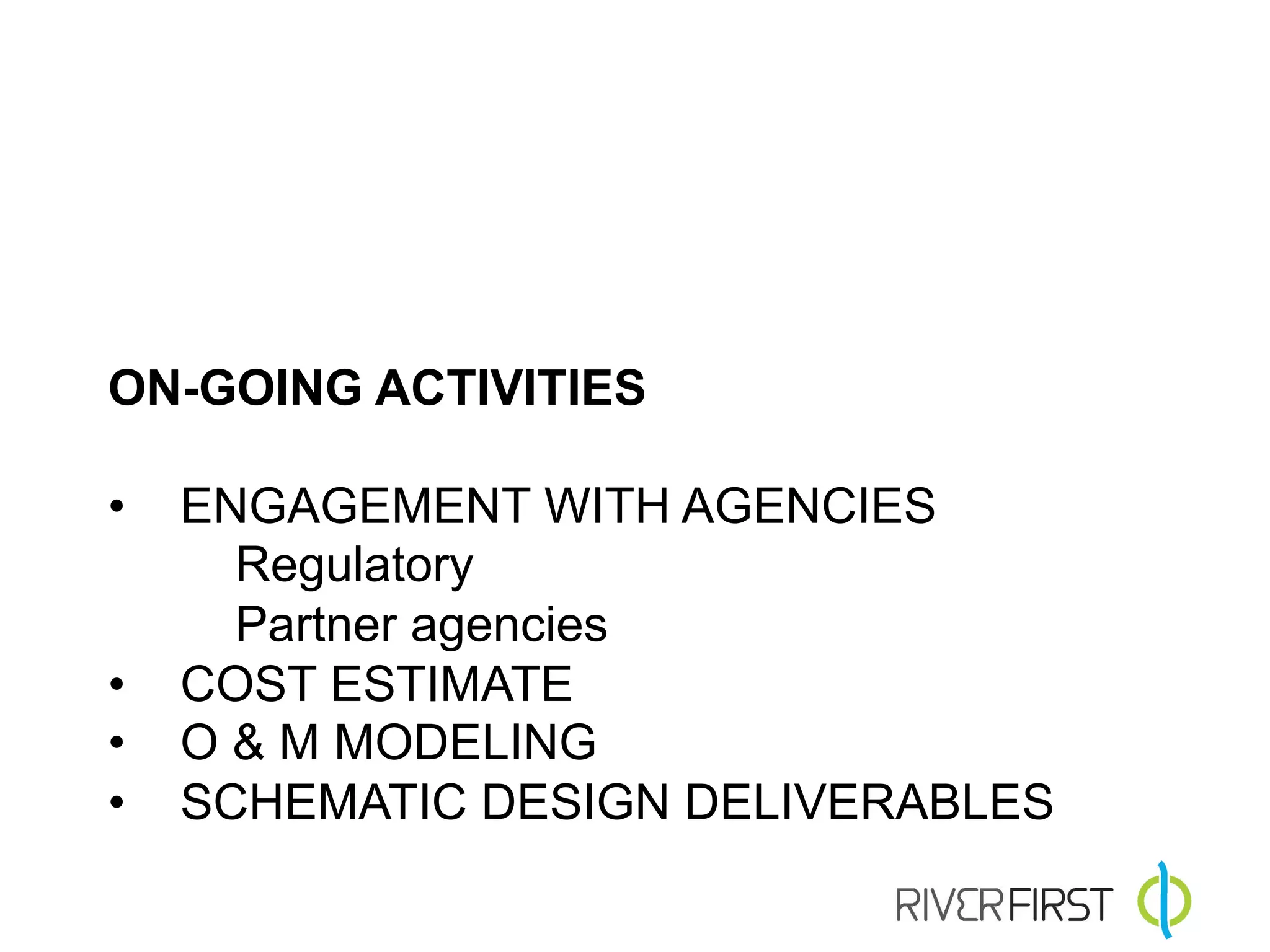

The document outlines the plans for an open house presentation by the Minneapolis Park and Recreation Board regarding development in an industrial zoning area with proposed uses including parks, retail, and recreational spaces. It details zoning regulations, building heights, setbacks, and the need for inter-agency collaboration along with regulatory challenges. The document emphasizes the feasibility study, design schema, and implementation opportunities for community enhancements.


![PowerISO 9.2 Mac Crack + Serial Key Free Download 2026 [Latest] Software.pptx](https://cdn.slidesharecdn.com/ss_thumbnails/software-251207185653-5d5700e6-thumbnail.jpg?width=640&height=640&fit=bounds)


![iStat Menus 7.20 Crack for MacOS 2026 Full Version [Latest] pptx](https://cdn.slidesharecdn.com/ss_thumbnails/softwareoverview-251207191544-22b737dc-thumbnail.jpg?width=640&height=640&fit=bounds)


![AnyTrans for iOS 8.9.14.20251127 With Crack for MacOS [Latest] pptx](https://cdn.slidesharecdn.com/ss_thumbnails/softwareoverview-251207190907-2316965f-thumbnail.jpg?width=640&height=640&fit=bounds)

