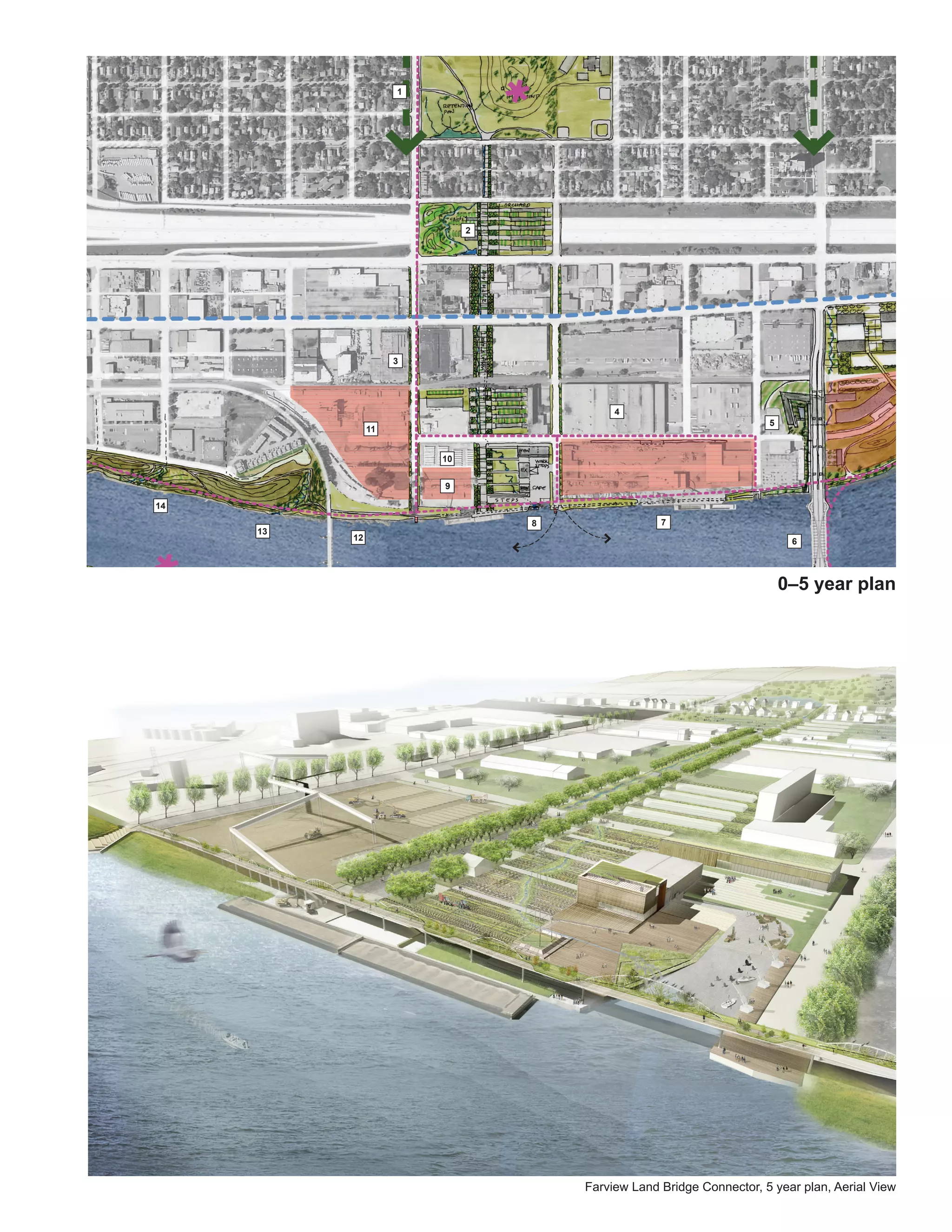
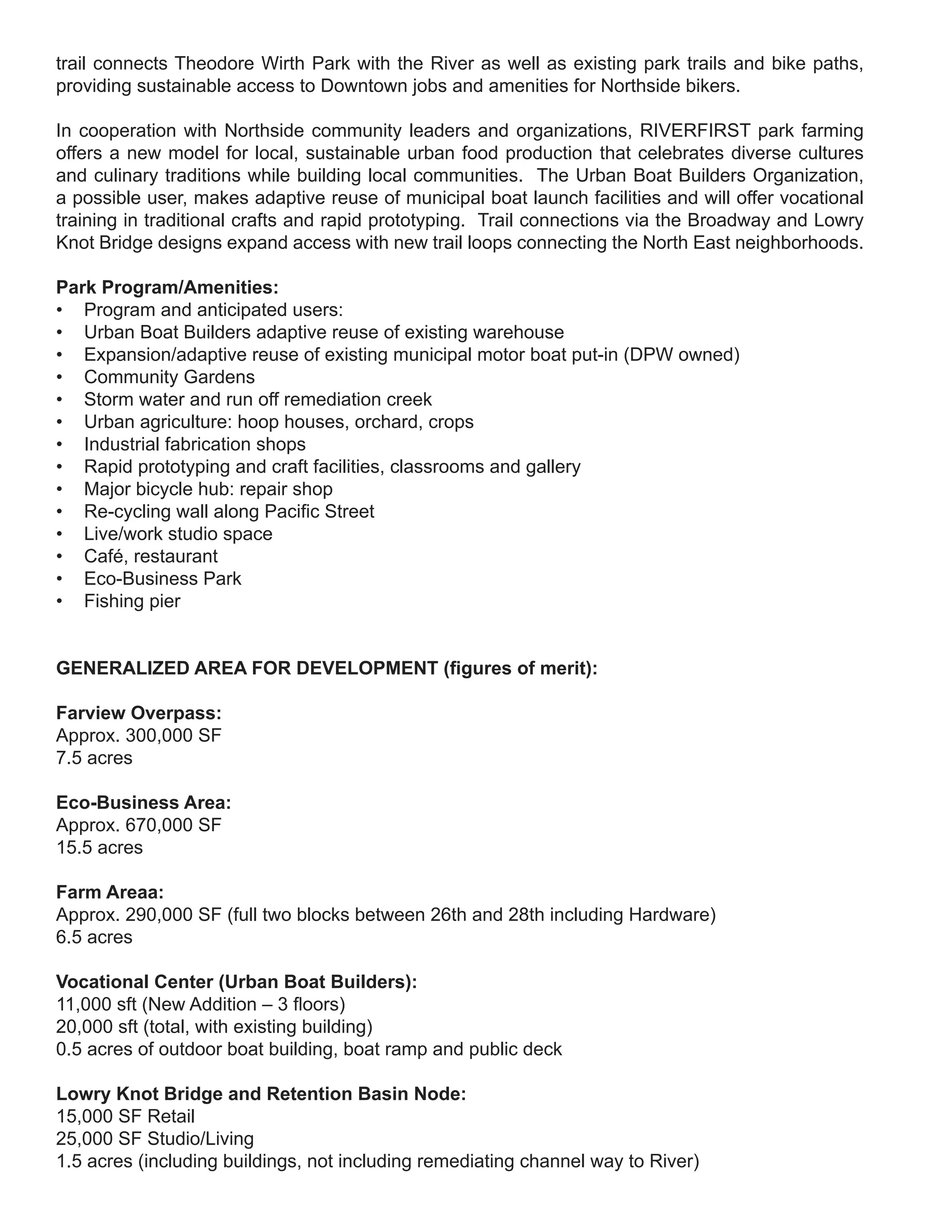
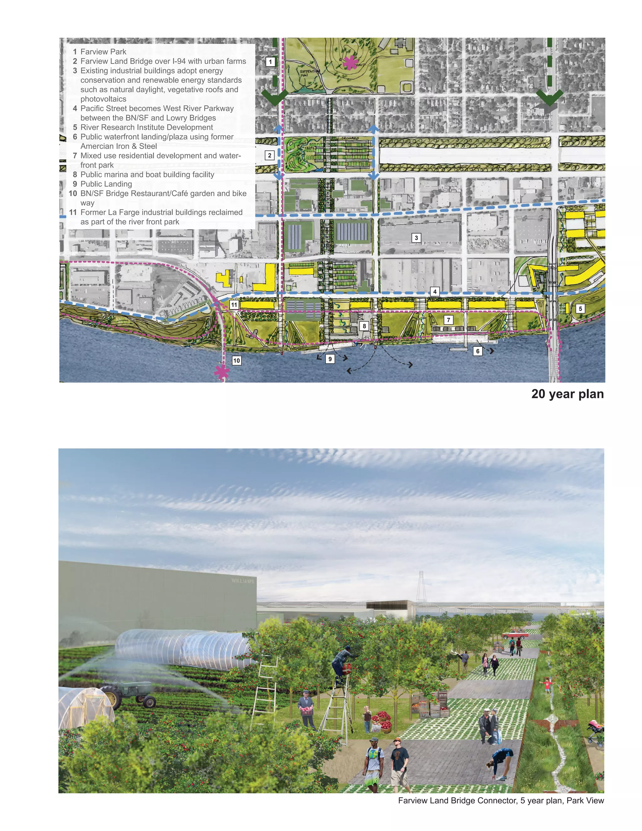
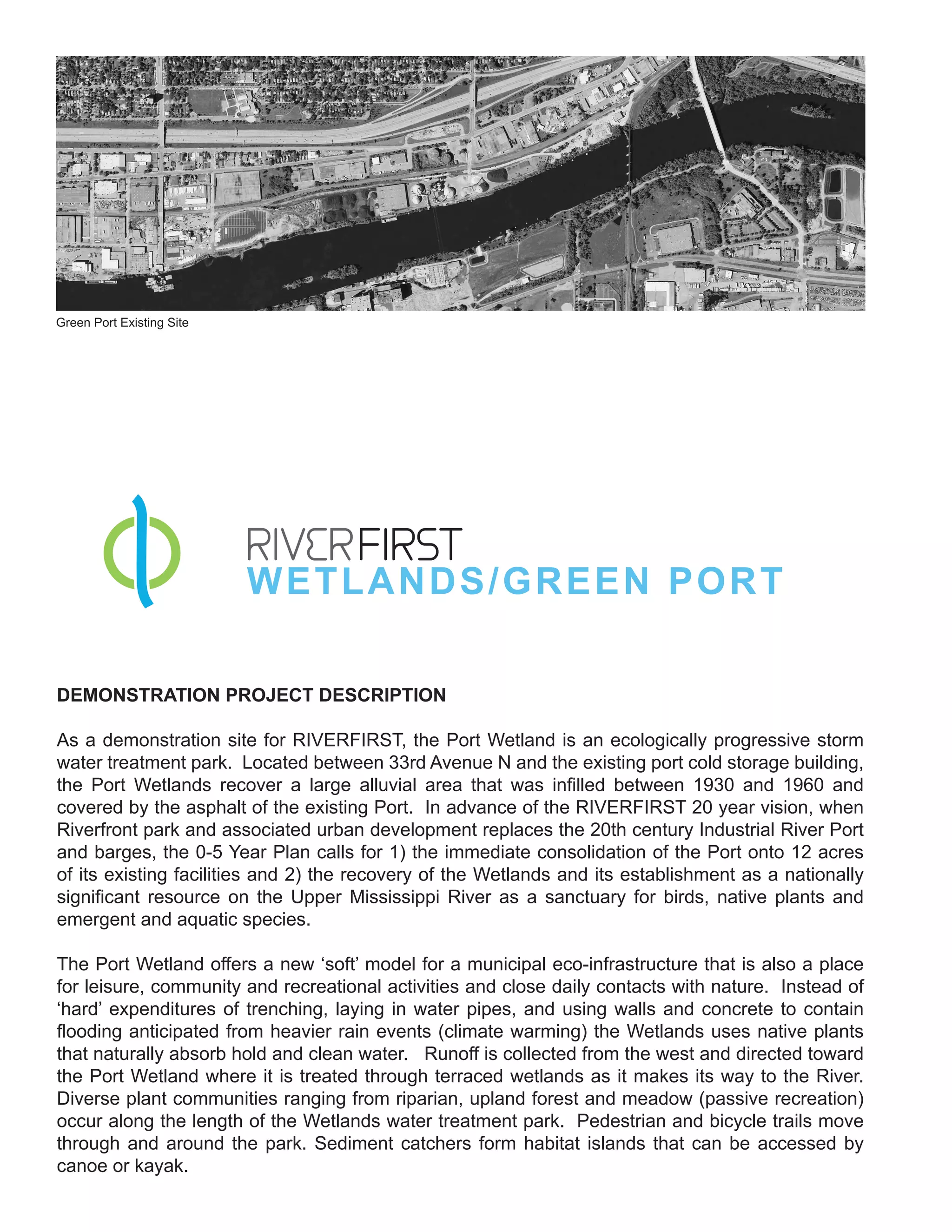
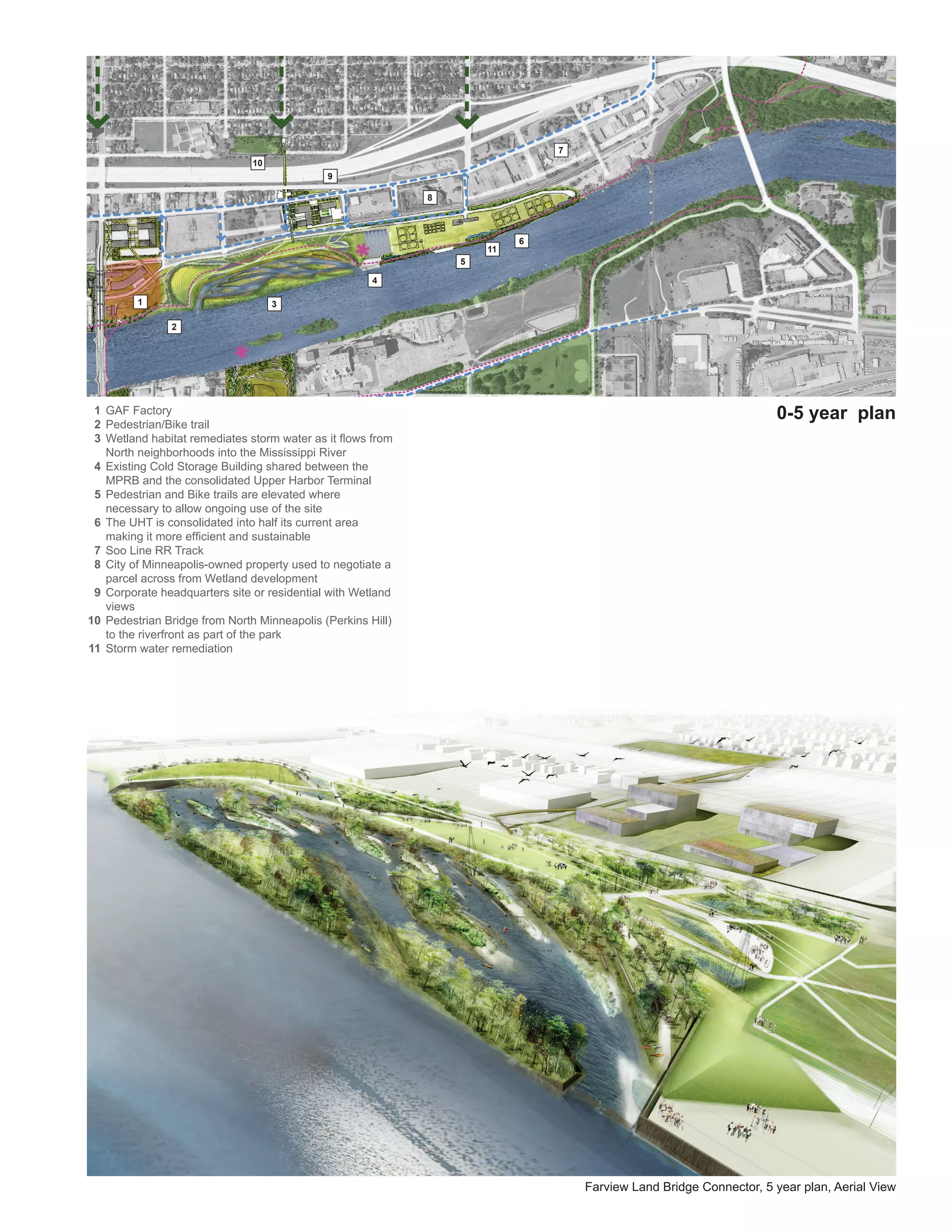
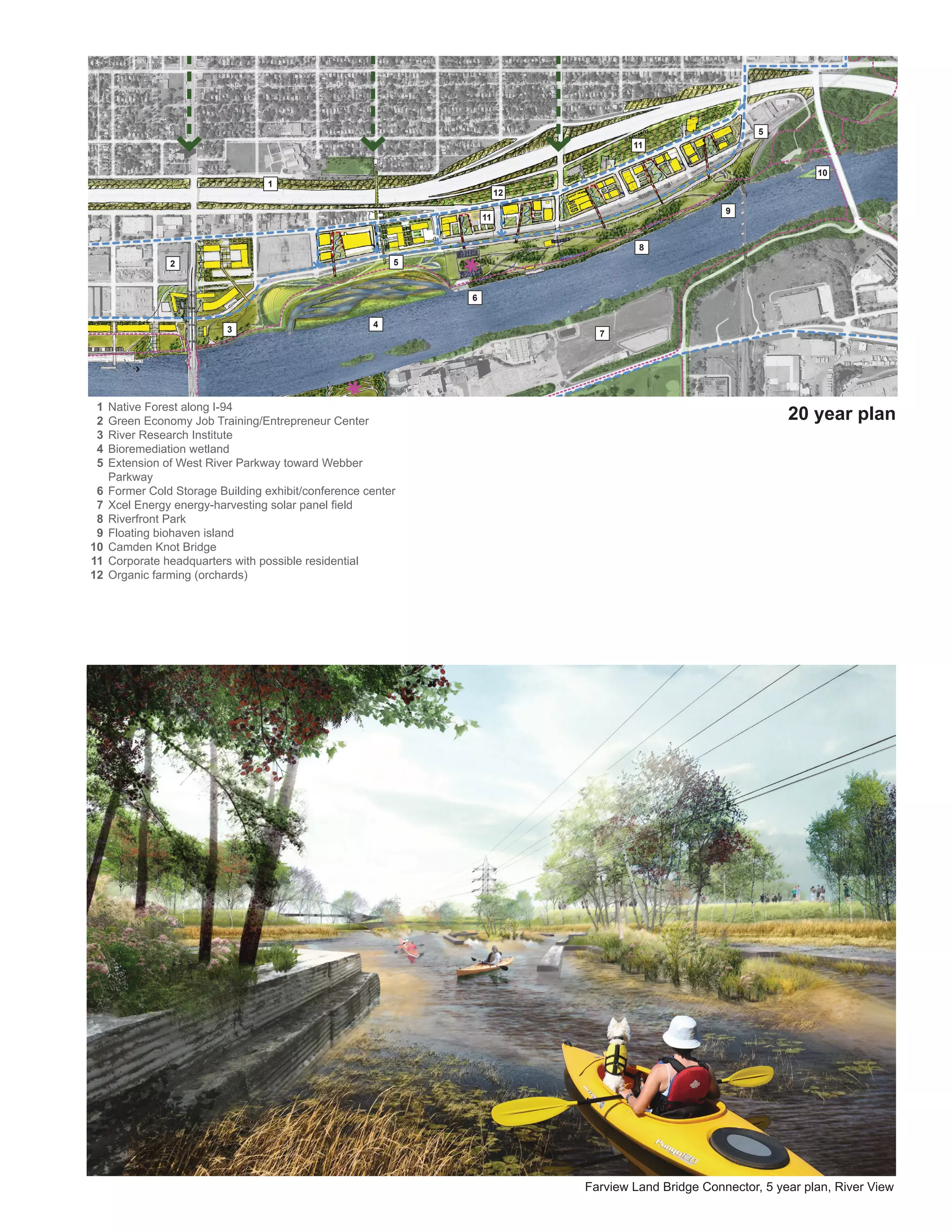
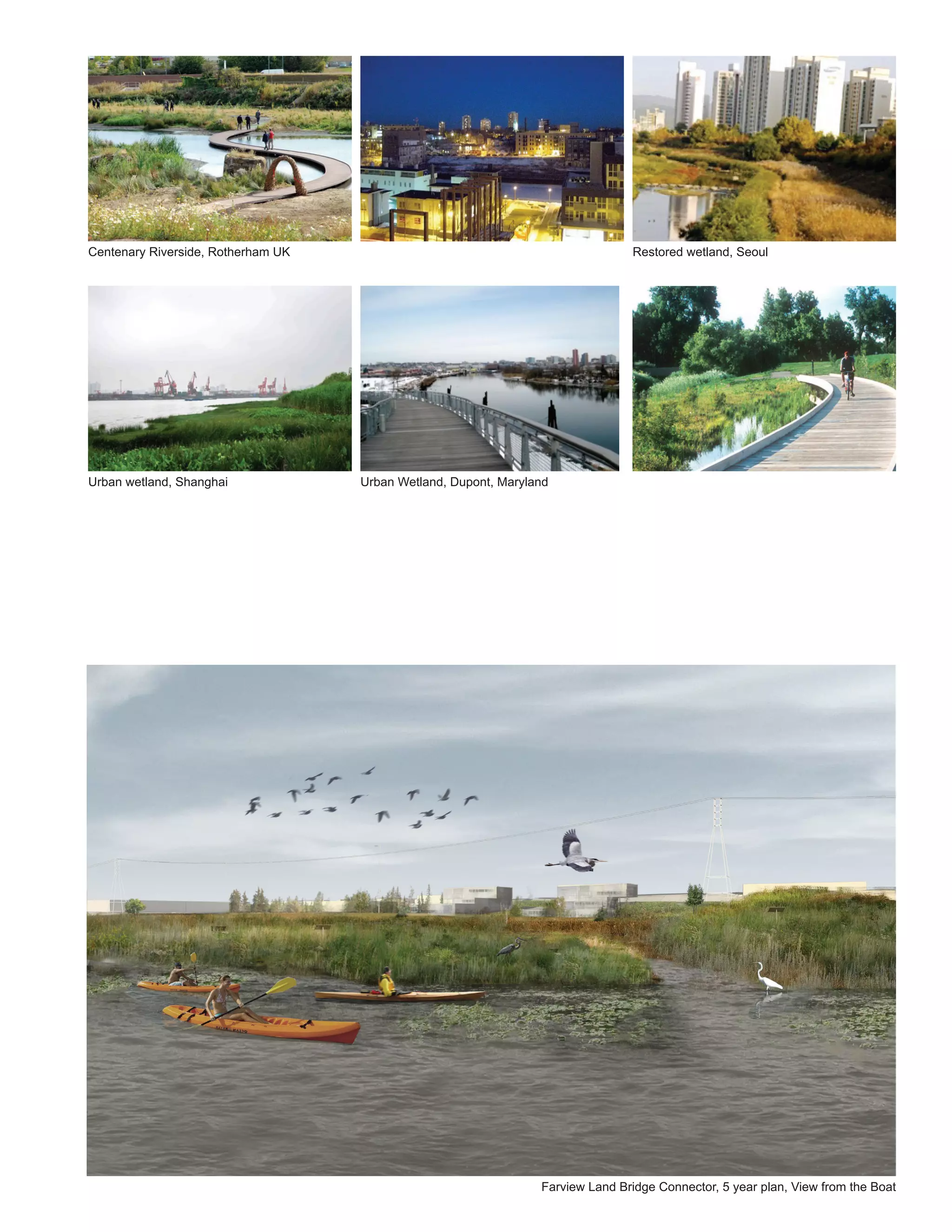
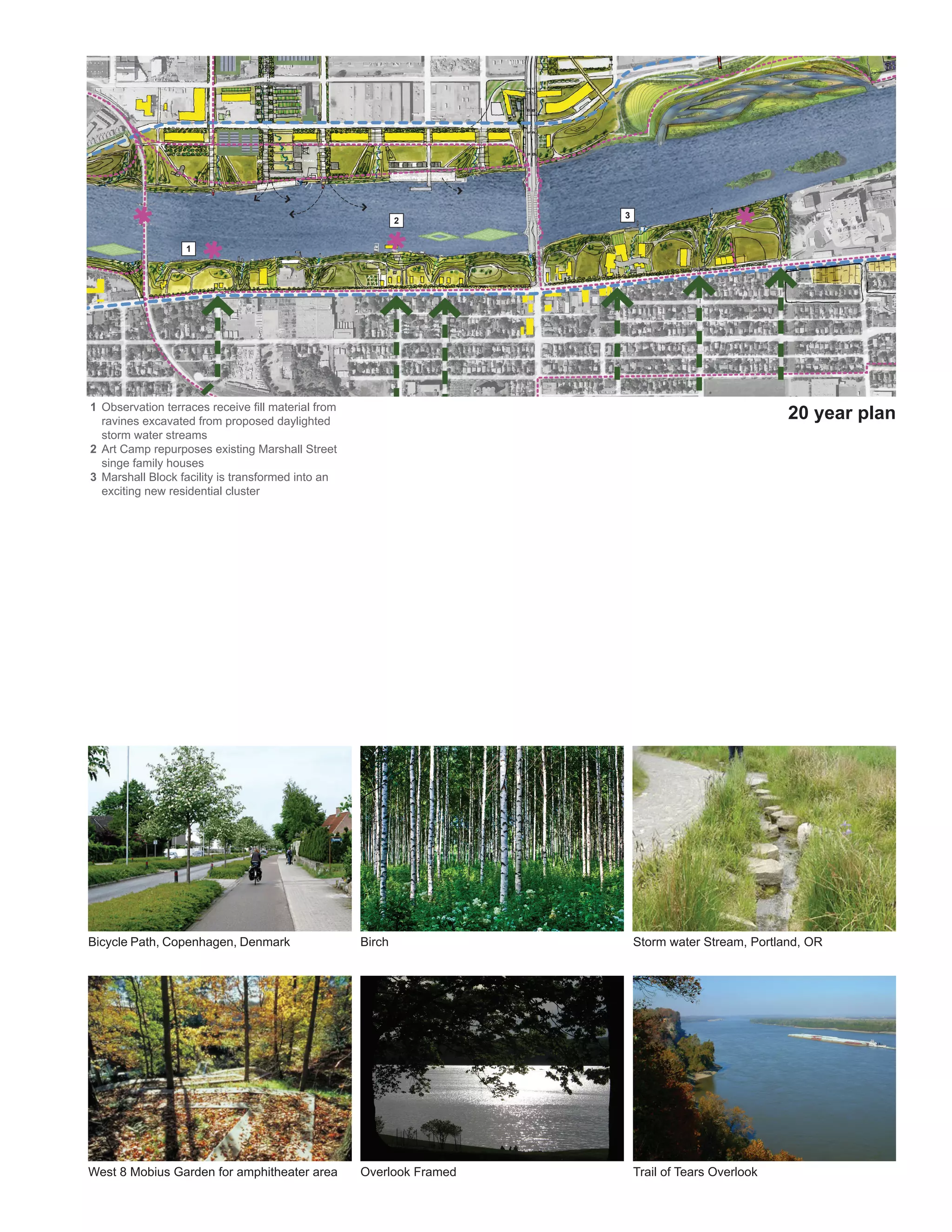
The Wetlands demonstration project would restore degraded wetlands along the Mississippi River and introduce public access. Key elements include:
1) Restoring native plantings and hydrology to create a dynamic wetland landscape along the river.
2) A trail network and boardwalks for public access that traverse high- and low-water zones, allowing exploration of the wetland.
3) An ecological education center to teach about wetland functions and values.
Mary deLaittre's presentation for neighborhood and community groups, highlighting RiverFIRST projects and other important information relevant to near- and long-term Upper Riverfront parks development in Minneapolis
Details proposed island restoration in the Upper Mississippi as part of an ecologically sustainable, multifunctional riverfront park design.
TLS/KVA presentation, prepared with Kestrel Design Group, InterFluve and Barr Engineering, and given to the Minnesota Department of Natural Resources and U.S. Army Corps of Engineers.
DNR and USACE are regulatory agencies overseeing the RiverFirst area.
BC Hydro Experience with Environmental Management: British Colombia, CanadaCPWF Mekong
By Sokhem Pech, Hatfield Consultant and M-Power
Presented at the Mekong Forum on Water, Food and Energy
Phnom Penh, Cambodia
December 7-9, 2011
Session 1: Managing water resources development within a water-food-energy nexus
A resource document about strategies for low-impact development/green infrastructure techniques to effectively manage stormwater. Presented by Rich Claytor, engineer with Horsley Witten Group, during the Buzzards Bay Coalition's 2013 Decision Makers Workshop series. Learn more at www.savebuzzardsbay.org/DecisionMakers
Cynefin meets the Maribyrnong and Moonee Ponds CreekTony Smith
Presentation to Melbourne Emergence Meetup of a mid-course reflection on the progress of Melbourne Water's Health Waterways Refresh Catchment Collaborations. The process has drawn on Dave Snowden's Cynefin framing via Twyfords.
Dwindling availability of water, combined with increases and competition in demand, climate change impacts, trends toward true cost water pricing, among other “drivers,” necessitates that urban water planning incorporate consideration of strategies for use, conservation, and reuse of treated wastewater and stormwater. Three innovative initiatives will be discussed as illustrations of “win-win” approaches that achieve effective water management (urban water security/sustainability) while facilitating economic development.
Showcase of landscape architecture projects, concepts, and competency spanning multiple scales and styles.
Body of work was envisioned or completed in California, thus adhering to sustainability/green building ethos, ecology/environmental consciousness, and adaptable to the breadth of microclimates found in the northern part of the state.
Nov 16 2016 nps presentation west pond[2995]ecowatchers
Presentation by NPS Superintendent Jen Neresian on the project to repair the West Pond and the restoration work underway at the North and South Gardens
The metropolitan area of Eastern Pima County Arizona is developing and implementing a Regional Optimization Master Plan (ROMP) as a $720 million program to modernize and upgrade the two major RWRD metropolitan treatment facilities. These modernizations will improve the water quality for recharge and reuse, develop a state of the art water quality laboratory, incorporate solar and rainwater harvesting features, and will help to develop habitat and birding features. The Pima County/Tucson team will present the ongoing collaboration with the water research scientists at the University of Arizona, Pima Association of Governments, Tucson Audubon Society and other community organizations to proudly transform these RWRD treatment facilities into a water-centric focus area for the region, capitalizing on the natural beauty of the Santa Cruz River and the award winning area of the Tucson Sweetwater Wetlands.
Landscape Record - Urban Renewal and RegenerationMike Brown
Successful urban parks and other public places play an important role in the formation of economic value in a city. St Pete Florida has positioned its public spaces to serve an asset to the local economy and community.
Urban eco-constructs_Port Philip bay ecocenter_presentation_20th may 2007Archana Sharma
Urban eco-constructs studio challenged the students to investigate and employ natural ecosystems and eco-systemic cycles as a model for landscape design.
Studio works of Monique Govers, Nicholas Beer, Bride Blake (Chlorophyll park), Keith Farnsworth, Faculty advisor: Archana Sharma
In this presentation you'll get a preview of the public-private funding strategies for RiverFirst. Included are demographic maps of the RiverFirst area, key themes for implementation, findings about perception and approach to implementation, and broad Priority Project funding projections.
Donjek Inc. of St. Paul, Minnesota, completed the Finance Strategy research and analysis and prepared these Initial Findings.
Executive Summary: Schematic Design, Finance Strategy and Next StepsRiverFirst Initiative
Where are we going and how are we going to pay for it? These questions are tackled - in summary - in the following document. This executive summary is the companion to two additional presentations made by the RiverFirst team. Check out the schematic design and funding strategy presentations uploaded May 2 for more detail.
Schematic Design of RiverFirst Priority Projects is progressing well, as this presentation from TLS/KVA, the RiverFirst Design Team, demonstrates. In this document, you'll see evidence of the Design Team's flexible approach to developing parks and development side-by-side, over time. These iterations of the original RiverFirst Vision remain true to the RiverFirst principles - Go with the Flow, Design with Topography, Both/And, Parks Plus - while adapting to the existing conditions. See schematics for: "Loops" of Mississippi Riverfront trails and bridge paths, connecting avenues, a kit of parts for a dynamic wayfinding proposal, and man-made bio-islands to float seasonally in the Mississippi River. Look especially for Scherer Park, where the restoration of Hall's Island makes way for a protected cove and beach, brings historic interest and, most importantly, is the first of multiple habitat patches needed to transform the Upper Riverfront from "ditch" to destination - for people and creatures.
What interests some Minnesotans most about RiverFirst? Jon Commers, Principal of Donjek, told our Steering Committee on January 17, that three themes are emerging from his research:
Interest in how RiverFirst binds together separate sites
Eagerness for immediate demonstration
Desire to make RiverFirst concrete for the public
Donjek is preparing the RiverFirst Funding Strategy, scheduled for release this July. Commers and his team have been interviewing leaders in the private, public and nonprofit sectors, along with other stakeholders.
Flip through his summary presentation below for more information.
RiverFirst: A Park Design Proposal and Implementation Framework for the Minneapolis Upper Riverfront.
A 20-year vision to re-create the quintessential Mississippi Riverfront city -- for the 21st century and beyond.
Authors: Tom Leader Studio, Kennedy & Violich Architecture under the Minneapolis Park Board's Minneapolis Riverfront Development Initiative, with Groundwork City Building and HR&A Advisors.
Slideshow: RiverFirst Design and Implementation Plan (presented Sept 2011)RiverFirst Initiative
RiverFirst riverfront parks development proposal implementation plan slideshow, presented by HRA finance consultants and TLS/KVA, September 2011 in Minneapolis.
RiverFIRST: A Parks Design Proposal and Implementation Framework for the Min...RiverFirst Initiative
(compressed file)
RiverFIRST: A Parks Design Proposal and Implementation Framework for the Minneapolis Upper Riverfront
A 20-year city-building vision to reconnect people from near and far wit with one of the three great rivers of the world and "America's fourth coast."
Design Tom Leader Studio and Kennedy and Violich Architecture lead a multifaceted team of professionals to conceptualize five 21-st century parks for development within five years. These projects will revolutionize how we interact with the river, its landscape, our city and each other.
HR&A consultants contributed analysis and recommendations to the 5-year implementation plan.
Includes implementation grid, community engagement survey results, and letters of support and comments from more than 30 organizations and individuals.
(For reproduction-quality images, please contact us.)
TLS/KVA is the design partner of the Minneapolis Riverfront Development Initiative (MR|DI). In this presentation, the design team outlines their design criteria for identifying priority parks projects - sites and/or systems - for development along the Upper Riverfront in Minneapolis within the next five years.
Securing your Kubernetes cluster_ a step-by-step guide to success !KatiaHIMEUR1
Today, after several years of existence, an extremely active community and an ultra-dynamic ecosystem, Kubernetes has established itself as the de facto standard in container orchestration. Thanks to a wide range of managed services, it has never been so easy to set up a ready-to-use Kubernetes cluster.
However, this ease of use means that the subject of security in Kubernetes is often left for later, or even neglected. This exposes companies to significant risks.
In this talk, I'll show you step-by-step how to secure your Kubernetes cluster for greater peace of mind and reliability.
Essentials of Automations: Optimizing FME Workflows with ParametersSafe Software
Are you looking to streamline your workflows and boost your projects’ efficiency? Do you find yourself searching for ways to add flexibility and control over your FME workflows? If so, you’re in the right place.
Join us for an insightful dive into the world of FME parameters, a critical element in optimizing workflow efficiency. This webinar marks the beginning of our three-part “Essentials of Automation” series. This first webinar is designed to equip you with the knowledge and skills to utilize parameters effectively: enhancing the flexibility, maintainability, and user control of your FME projects.
Here’s what you’ll gain:
- Essentials of FME Parameters: Understand the pivotal role of parameters, including Reader/Writer, Transformer, User, and FME Flow categories. Discover how they are the key to unlocking automation and optimization within your workflows.
- Practical Applications in FME Form: Delve into key user parameter types including choice, connections, and file URLs. Allow users to control how a workflow runs, making your workflows more reusable. Learn to import values and deliver the best user experience for your workflows while enhancing accuracy.
- Optimization Strategies in FME Flow: Explore the creation and strategic deployment of parameters in FME Flow, including the use of deployment and geometry parameters, to maximize workflow efficiency.
- Pro Tips for Success: Gain insights on parameterizing connections and leveraging new features like Conditional Visibility for clarity and simplicity.
We’ll wrap up with a glimpse into future webinars, followed by a Q&A session to address your specific questions surrounding this topic.
Don’t miss this opportunity to elevate your FME expertise and drive your projects to new heights of efficiency.
Dev Dives: Train smarter, not harder – active learning and UiPath LLMs for do...UiPathCommunity
💥 Speed, accuracy, and scaling – discover the superpowers of GenAI in action with UiPath Document Understanding and Communications Mining™:
See how to accelerate model training and optimize model performance with active learning
Learn about the latest enhancements to out-of-the-box document processing – with little to no training required
Get an exclusive demo of the new family of UiPath LLMs – GenAI models specialized for processing different types of documents and messages
This is a hands-on session specifically designed for automation developers and AI enthusiasts seeking to enhance their knowledge in leveraging the latest intelligent document processing capabilities offered by UiPath.
Speakers:
👨🏫 Andras Palfi, Senior Product Manager, UiPath
👩🏫 Lenka Dulovicova, Product Program Manager, UiPath
GraphRAG is All You need? LLM & Knowledge GraphGuy Korland
Guy Korland, CEO and Co-founder of FalkorDB, will review two articles on the integration of language models with knowledge graphs.
1. Unifying Large Language Models and Knowledge Graphs: A Roadmap.
https://arxiv.org/abs/2306.08302
2. Microsoft Research's GraphRAG paper and a review paper on various uses of knowledge graphs:
https://www.microsoft.com/en-us/research/blog/graphrag-unlocking-llm-discovery-on-narrative-private-data/
GDG Cloud Southlake #33: Boule & Rebala: Effective AppSec in SDLC using Deplo...James Anderson
Effective Application Security in Software Delivery lifecycle using Deployment Firewall and DBOM
The modern software delivery process (or the CI/CD process) includes many tools, distributed teams, open-source code, and cloud platforms. Constant focus on speed to release software to market, along with the traditional slow and manual security checks has caused gaps in continuous security as an important piece in the software supply chain. Today organizations feel more susceptible to external and internal cyber threats due to the vast attack surface in their applications supply chain and the lack of end-to-end governance and risk management.
The software team must secure its software delivery process to avoid vulnerability and security breaches. This needs to be achieved with existing tool chains and without extensive rework of the delivery processes. This talk will present strategies and techniques for providing visibility into the true risk of the existing vulnerabilities, preventing the introduction of security issues in the software, resolving vulnerabilities in production environments quickly, and capturing the deployment bill of materials (DBOM).
Speakers:
Bob Boule
Robert Boule is a technology enthusiast with PASSION for technology and making things work along with a knack for helping others understand how things work. He comes with around 20 years of solution engineering experience in application security, software continuous delivery, and SaaS platforms. He is known for his dynamic presentations in CI/CD and application security integrated in software delivery lifecycle.
Gopinath Rebala
Gopinath Rebala is the CTO of OpsMx, where he has overall responsibility for the machine learning and data processing architectures for Secure Software Delivery. Gopi also has a strong connection with our customers, leading design and architecture for strategic implementations. Gopi is a frequent speaker and well-known leader in continuous delivery and integrating security into software delivery.
UiPath Test Automation using UiPath Test Suite series, part 4DianaGray10
Welcome to UiPath Test Automation using UiPath Test Suite series part 4. In this session, we will cover Test Manager overview along with SAP heatmap.
The UiPath Test Manager overview with SAP heatmap webinar offers a concise yet comprehensive exploration of the role of a Test Manager within SAP environments, coupled with the utilization of heatmaps for effective testing strategies.
Participants will gain insights into the responsibilities, challenges, and best practices associated with test management in SAP projects. Additionally, the webinar delves into the significance of heatmaps as a visual aid for identifying testing priorities, areas of risk, and resource allocation within SAP landscapes. Through this session, attendees can expect to enhance their understanding of test management principles while learning practical approaches to optimize testing processes in SAP environments using heatmap visualization techniques
What will you get from this session?
1. Insights into SAP testing best practices
2. Heatmap utilization for testing
3. Optimization of testing processes
4. Demo
Topics covered:
Execution from the test manager
Orchestrator execution result
Defect reporting
SAP heatmap example with demo
Speaker:
Deepak Rai, Automation Practice Lead, Boundaryless Group and UiPath MVP
Slack (or Teams) Automation for Bonterra Impact Management (fka Social Soluti...Jeffrey Haguewood
Sidekick Solutions uses Bonterra Impact Management (fka Social Solutions Apricot) and automation solutions to integrate data for business workflows.
We believe integration and automation are essential to user experience and the promise of efficient work through technology. Automation is the critical ingredient to realizing that full vision. We develop integration products and services for Bonterra Case Management software to support the deployment of automations for a variety of use cases.
This video focuses on the notifications, alerts, and approval requests using Slack for Bonterra Impact Management. The solutions covered in this webinar can also be deployed for Microsoft Teams.
Interested in deploying notification automations for Bonterra Impact Management? Contact us at sales@sidekicksolutionsllc.com to discuss next steps.
Key Trends Shaping the Future of Infrastructure.pdfCheryl Hung
Keynote at DIGIT West Expo, Glasgow on 29 May 2024.
Cheryl Hung, ochery.com
Sr Director, Infrastructure Ecosystem, Arm.
The key trends across hardware, cloud and open-source; exploring how these areas are likely to mature and develop over the short and long-term, and then considering how organisations can position themselves to adapt and thrive.
Encryption in Microsoft 365 - ExpertsLive Netherlands 2024Albert Hoitingh
In this session I delve into the encryption technology used in Microsoft 365 and Microsoft Purview. Including the concepts of Customer Key and Double Key Encryption.
UiPath Test Automation using UiPath Test Suite series, part 3DianaGray10
Welcome to UiPath Test Automation using UiPath Test Suite series part 3. In this session, we will cover desktop automation along with UI automation.
Topics covered:
UI automation Introduction,
UI automation Sample
Desktop automation flow
Pradeep Chinnala, Senior Consultant Automation Developer @WonderBotz and UiPath MVP
Deepak Rai, Automation Practice Lead, Boundaryless Group and UiPath MVP
2. 1 Plymouth Knot Bridge
2 Reclaimed Hall Island
3 Swimming Barge
4 Scouring Channel/Kayak Put-in
5 Riparian Wetland
6 Canoe/Kayak Center
7 Residential /Mixed use Development
8 Graco
9 Graco riverfront trail easement
10 Floating Biohaven Island
11 Arts District Performance Green/Stage
12 Playground
Scherer Park Existing Site
S C H E R ER PARK
DEMONSTRATION PROJECT DESCRIPTION
Located along the only Minneapolis urban river bend with South/West solar exposure, the new
Scherer Park restores Halls Island and introduces the public to the core idea of the River as a living,
dynamic ecosystem. The new park is designed so the River produces its own dynamic riparian
landscape of sand bars, streams and shallows according to winter melts, patterns of sediment
deposition and river flows.
The Scherer Park river beach channel offers direct public access to the River for kayaking, canoeing,
floating rafts and ice skating. The park is organized in high- and low-water zones, with a playful set
of large undulating wooden ‘deck chairs’ recalling the site’s logging history and providing places for
relaxation and sunning. Seasonal fluctuation of the Mississippi’s water level transforms the park
beach as the wood decks are revealed and hidden depending on the time of year. The park also
serves as an ecological storm demonstration with a storm water treatment stream that makes its
way from the park entry down to the River flanked by riparian vegetation. Meadow plantings occur
in the center of the site and lawns and grasses make up the upper edge.
Hall Island provides a docking point to support a swimming barge in summer and a skating rink in
winter. Hall Island contains both hard and soft edges creating a riparian forest condition on the soft
edges with upland species toward the center of the Island.
As a demonstration site for RIVERFIRST, market rate housing, a community art center and
3. 10
9
3
1 2 11
8 12
4
5 9
7
6
8
0–5 year plan
Scherer Park, 5 year plan, Aerial View
4. combined boathouse and rental facilities for kayaks, canoes and bicycles define the edges of the
park, bringing people, safety and activity to the park corridor. The new housing comprises 200
units of market rate dwellings which overlook the River and the park and enjoy spectacular views.
Structured parking for residents buffers the Graco Building, with retail elements and restaurants
making use of Minneapolis park-grown organic produce and locally-sourced food.
The community art center will provide an opportunity for working adults, youth and retirees to
access studio space and develop their skills. Working artists from the area will gain an opportunity
to network, teach, and exhibit at the Center, allowing the park system to link to the creative energy
of the Northeast Minneapolis Arts District and the Broadway River District on the North side.
Park Program/Amenities:
• Storm water treatment bio-remediation creek
• Public Sun Deck and Urban Deck ‘Chairs’ of reclaimed wood
• Gravel Beach
• Swimming Barge with changing station, public amenities
• Riverside Skating area possible in winter
• Pedestrian/Bike Paths
• Wood Bridge from Scherer Park to Hall Island
• Kayak/sport rental facilities
• Kayak launch from Halls Island
• Community Art Center, Art Classrooms & Gallery
• Work/Live art studio spaces
• Residential Housing
• Retail, Restaurants
• Parking Facility
Users: the community, including artists, the elderly, people from adjacent residential neighborhoods,
outdoor water sport enthusiasts, summer camp youth, and science teachers/students
GENERALIZED AREA FOR DEVELOPMENT (figures of merit):
12.5 acres (including buildings, park and island, not including river channel)
1 Broadway Knot Bridge
2 Residential/Hotel Development
3 Cultural/Arts Institution (Bell Museum)
4 Storm Water Daylight Streams
5 Riverfront courtyard residential
6 Increased urban density/parcel development
7 Graco green roof and photovoltaic installation
5. 2
3
4
1
7 5
6
20 year plan
Scherer Park, 5 year plan, River View
6. SITE SELECTION: PRIORITY CRITERIA
Community Benefits
Health/Recreation (Unique River Beach Shore):
Scherer Park offers the only place in the Minneapolis and Twin Cities area where the public has
direct access to living river shore beach ecology. The south-facing exposure makes this a unique
civic place of national importance on the River. Educational and recreational potentials of direct
enjoyment and engagement with the River are crucial to implement a public change of culture about
the role of the River. A broad cross-section of the public can benefit from this urban launch point
including schools, nature organizations and youth programs.
Sustainable Transportation/Public Access:
The new Scherer Park is in a strategic location which links to existing park trails from the south and
serves as the central public launching point and trailhead for all to explore the new RIVERFIRST
trails by kayak, foot, bicycle, or skis. Plymouth Bridge, with the proposed Knot Bridge, will facilitate
sustainable pedestrian and Nice Ride access as well as East-West linkage between the North and
Northeast neighborhoods.
Municipal Need:
Improve tax base and generate revenue stream for National Parks Service
Create a model for new public/private development for other Park’s sites
Mitigate against flooding on this River bend through use of natural absorptive surfaces
Remediate municipal storm water flows and run off, improve river health
Tie Knot Bridge implementation with planned improvements to Plymouth Bridge
Timing/Land Acquisition:
• Parks owns the land, and has funds to help with remediation
• No site acquisition required
Demonstration Potentials:
Scherer Park and the Plymouth Knot Bridge demonstrate the full set of RIVERFIRST design concepts
and intentions: health/recreation as a major new trailhead and watercraft launch point; economic
development potential to increase the tax base and strengthen regional economic identity based on
a new approach to the ecology of the UMR, sustainable transportation and water.
Critical Path Indicators – incentives and obstacles to funding and development
• Parks owns land, has funding for environmental remediation
• Proposed residential development would generate significantly property tax base than current
commercial facilities
• Unique municipal public launching point and trailhead for RIVERFIRST watercraft and trails
• Hydrology/sediment modeling needs to be done for Hall Island restoration
• Work with the Army Corps of Engineers – address potential obstacles with cut/fill along river and
potential use of dredge fill. Since Hall Island already exists, it has been “aggregated” and infilled
with land and so the consequences of returning it to a channel need to be studied and approved
by Army Corps
• Quantify/evaluate commercial, residential and retail potentials
• Financial site prospectus and ROI needed for potential developers
7. Green Street, Denmark Sea Salt Eatery Metamorphosis 1: Waitangi Park, NZ
Jose Ulloa Davet + Delphine Ding
MOD 05 Living Hotel: Bo01, Malmö, Sweden Villa Macklin: Huttunen–Lipasti– Bo01, Malmö, Sweden
Enrica Mosciaro Pakkanen Architects
Scherer Park, 5 year plan, View from the Boat
8. 1 Farview Park
2 27th Ave Walk Street and Remediation Stream
3 26th Ave Bike Path extension
4 Pacific Street Bike By-pass (Pedestrian Trail if
Industries will not allow riverfront easement)
5 Lowry Bridge pedestrian and bike access
including retention pond and Exhibit Center
6 Lowry Bridge bike and pedestrian sidewalk
7 Temporary elevated pedestrian walkway
8 Marina and boat builders workshop facility
9 Aggregate Industries barge landing
10 Centerpoint Energy
11 La Farge
12 BN/SF Bridge
13 Riparian forest and reconfigured landscape for
storm water
14 Daylighted storm water streams
Farview Land Bridge Connector Existing Site
FARVIEW LAND BRIDGE
DEMONSTRATION PROJECT DESCRIPTION
The Farview Land Bridge Connector will reconnect the City’s topographic high point with the River,
and allow the natural topography to extend across I-94 to provide Northside neighborhoods with
public access to the River and to the proposed River City Innovation district. Using the natural
land slope, Farview Park and Land Bridge channel storm water collected from the Farview Park
hill to a retention pond. The water then travels down along the new overpass bridge, continuing
along the 27th Avenue N right-of-way, which is reclaimed as a public green street with storm water
remediation creek, new plantings and previous street treatments.
The Farview Land Bridge, featuring a green space to meet the needs of Northside neighborhoods,
is the centerpiece for the new River City Innovation District that draws on Minneapolis’ expertise in
innovative materials, medical, scientific and smart technologies. A zone of four to six story office
and light industrial buildings, such as the successful new Coloplast Corporate Headquarters, are
proposed in the 20 Year RIVERFIRST Master Plan vision.
In the 0-5 Year Plan, a sustainable Eco Business Park, the first in Minneapolis, will provide a core
test bed and starting point for the transformation of this area. Eco-Park Business owners might
have City incentives to improve their proprieties with green roofs, day lighting, energy efficient
business practices and renewable solar power. The 26th Avenue N bike trail initiative forms an
important first axis to the River in the 0-5 Year Plan. In the 5 Year Plan, 26th Avenue N is extended
down from Farview Park to touch the River with a new public fishing pier. The 26th Avenue N Bike
9. 1
2
3
4
5
11
10
9
9
14
13
8
8 7
12 6
0–5 year plan
Farview Land Bridge Connector, 5 year plan, Aerial View
10. trail connects Theodore Wirth Park with the River as well as existing park trails and bike paths,
providing sustainable access to Downtown jobs and amenities for Northside bikers.
In cooperation with Northside community leaders and organizations, RIVERFIRST park farming
offers a new model for local, sustainable urban food production that celebrates diverse cultures
and culinary traditions while building local communities. The Urban Boat Builders Organization,
a possible user, makes adaptive reuse of municipal boat launch facilities and will offer vocational
training in traditional crafts and rapid prototyping. Trail connections via the Broadway and Lowry
Knot Bridge designs expand access with new trail loops connecting the North East neighborhoods.
Park Program/Amenities:
• Program and anticipated users:
• Urban Boat Builders adaptive reuse of existing warehouse
• Expansion/adaptive reuse of existing municipal motor boat put-in (DPW owned)
• Community Gardens
• Storm water and run off remediation creek
• Urban agriculture: hoop houses, orchard, crops
• Industrial fabrication shops
• Rapid prototyping and craft facilities, classrooms and gallery
• Major bicycle hub: repair shop
• Re-cycling wall along Pacific Street
• Live/work studio space
• Café, restaurant
• Eco-Business Park
• Fishing pier
GENERALIZED AREA FOR DEVELOPMENT (figures of merit):
Farview Overpass:
Approx. 300,000 SF
7.5 acres
Eco-Business Area:
Approx. 670,000 SF
15.5 acres
Farm Areaa:
Approx. 290,000 SF (full two blocks between 26th and 28th including Hardware)
6.5 acres
Vocational Center (Urban Boat Builders):
11,000 sft (New Addition – 3 floors)
20,000 sft (total, with existing building)
0.5 acres of outdoor boat building, boat ramp and public deck
Lowry Knot Bridge and Retention Basin Node:
15,000 SF Retail
25,000 SF Studio/Living
1.5 acres (including buildings, not including remediating channel way to River)
11. 1 Farview Park
2 Farview Land Bridge over I-94 with urban farms 1
3 Existing industrial buildings adopt energy
conservation and renewable energy standards
such as natural daylight, vegetative roofs and
photovoltaics
4 Pacific Street becomes West River Parkway
between the BN/SF and Lowry Bridges
5 River Research Institute Development
6 Public waterfront landing/plaza using former
Amercian Iron & Steel
7 Mixed use residential development and water- 2
front park
8 Public marina and boat building facility
9 Public Landing
10 BN/SF Bridge Restaurant/Café garden and bike
way
11 Former La Farge industrial buildings reclaimed
as part of the river front park
3
4
11
5
7
9 8
8 6
10 9
20 year plan
Farview Land Bridge Connector, 5 year plan, Park View
12. SITE SELECTION: PRIORITY CRITERIA
Community Benefits
Public Access/Sustainable Transportation:
The Farview Connector provides a much needed direct, generous topographic link to the River that
enables underserved Northside residents to have multiple points of access to the Minneapolis Parks
system and the Riverfront. The 26th Avenue N bike trail provides, for the first time, a sustainable
recreational and commuter bike way from the Theodore Wirth Park to the River and Downtown.
Health/Recreation:
The Farview Connector design initiative enables parkland to become productive, multi-tasking
to provide a source for sustainable food, health education and good nutrition for the Northside
neighborhoods. A diverse range of school, church and community programs can become involved.
Municipal Need:
• Improve tax base with Eco-Park and Lowry Commercial Node, without displacing existing
businesses
• Generate revenue stream for National Park Service with orchards and sustainable foods
• Knot Bridge implementation may be dovetailed with ongoing construction of Lowry Bridg
• Comprehensive storm water cleaning and management of Farview design is a needed municipal
improvement and can be funded via state/federal grants
• City initiative Sustainable Minneapolis (2010) calls for urban agriculture development
Timing/Land Acquisition:
• The I-94 overpass will generate new land for development
• The design extends 26th Avenue N to the River, via the City owned right of way to the River
• The design uses former City-owned street right-of-way on 27th Avenue N as a storm water
green street
• Design proposes acquisition of the under utilized, vacant land adjacent to William’s Hardware
• Design proposes relocation of existing city owned maintenance facility on 28th Avenue N. and
Pacific Street or transformation to electric vehicle charging
• City DPW owns land on 28th Avenue N and Pacific Street along the River, proposed for Urban
Boat Builders program or equivalent boat related industry
• A raised pedestrian bridge is proposed for access over existing barge operations
• Pacific Street serves as a Bike lane bypass to the Lowry Bridge node
The County owns the Lowry retention basin parcel, with a proposed commercial node to increase
land value and public amenities. The County’s water retention pond is retained and improved in the
design with RIVERFIRST storm water treatment principles.
13. Green Roof (Before & After) Green Roof (Before & After) Seneca Freeway Park, Seattle, WA Cobble Unit Paving
Eagle Street Rooftop Farm, NYC Newton Street Farms NYC
Farview Land Bridge Connector, 5 year plan, View from the Boat
14. Demonstration Potentials:
The Farview Connector sector clearly demonstrates all key concepts of the RIVERFIRST proposal:
re-joining urban water and river flows, community access and community health through sustainable
agriculture on multi-tasking parklands, and public access to the Riverfront, economic development
and sustainable transportation and bike trail loops.
Critical Path Indicators – incentives and obstacles to funding and development:
• Job creation
• Hands-on job training in traditional and high tech fabrication
• Connection to North Minneapolis neighborhoods
• Bridging over I-94, the Duluth precedent has increased land value and River access
• 26th Avenue N bicycle connection
• Eco Business Park will generate more in property taxes than current facilities
• Timetable critical for change orders on Lowry Bridge node, as it is now under construction
• DPW owned land/boat ramp needs to be re-located or co-share new facility
• Street right of way approvals required from City for 26th and 27th Avenue improvements
• One key derelict land parcel (Pacific Street and 27th Avenue N) needs to be acquired
• Gas station needs to be acquired or relocated
15. Storm water stream Terraced landscape Parc Villeneuve
Bo01, Malmö, Sweden Bo01, Malmö, Sweden Copenhagen Harbour Bath: BIG Architect
Warehouse transformation, Basel: ZMIK MN Highway Overpass park provides River
acess, Duluth
16. Green Port Existing Site
W E T L ANDS/GREEN PORT
DEMONSTRATION PROJECT DESCRIPTION
As a demonstration site for RIVERFIRST, the Port Wetland is an ecologically progressive storm
water treatment park. Located between 33rd Avenue N and the existing port cold storage building,
the Port Wetlands recover a large alluvial area that was infilled between 1930 and 1960 and
covered by the asphalt of the existing Port. In advance of the RIVERFIRST 20 year vision, when
Riverfront park and associated urban development replaces the 20th century Industrial River Port
and barges, the 0-5 Year Plan calls for 1) the immediate consolidation of the Port onto 12 acres
of its existing facilities and 2) the recovery of the Wetlands and its establishment as a nationally
significant resource on the Upper Mississippi River as a sanctuary for birds, native plants and
emergent and aquatic species.
The Port Wetland offers a new ‘soft’ model for a municipal eco-infrastructure that is also a place
for leisure, community and recreational activities and close daily contacts with nature. Instead of
‘hard’ expenditures of trenching, laying in water pipes, and using walls and concrete to contain
flooding anticipated from heavier rain events (climate warming) the Wetlands uses native plants
that naturally absorb hold and clean water. Runoff is collected from the west and directed toward
the Port Wetland where it is treated through terraced wetlands as it makes its way to the River.
Diverse plant communities ranging from riparian, upland forest and meadow (passive recreation)
occur along the length of the Wetlands water treatment park. Pedestrian and bicycle trails move
through and around the park. Sediment catchers form habitat islands that can be accessed by
canoe or kayak.
17. 7
10
9
8
6
11
5
4
1 3
2
1 GAF Factory
2 Pedestrian/Bike trail
0-5 year plan
3 Wetland habitat remediates storm water as it flows from
North neighborhoods into the Mississippi River
4 Existing Cold Storage Building shared between the
MPRB and the consolidated Upper Harbor Terminal
5 Pedestrian and Bike trails are elevated where
necessary to allow ongoing use of the site
6 The UHT is consolidated into half its current area
making it more efficient and sustainable
7 Soo Line RR Track
8 City of Minneapolis-owned property used to negotiate a
parcel across from Wetland development
9 Corporate headquarters site or residential with Wetland
views
10 Pedestrian Bridge from North Minneapolis (Perkins Hill)
to the riverfront as part of the park
11 Storm water remediation
Farview Land Bridge Connector, 5 year plan, Aerial View
18. The Port Wetland is multi-functional in terms of ecological, social and educational impact. It accepts
dredge spoils and stockpiled land under remediation. It continues the trail network along the West
side, providing River access to the North neighborhoods. The Port Wetland also provides the St
Anthony Falls Laboratory with a highly desired site for sedimentary and hydrological research as
well as growing algae-based power cells.
The consolidated Port can retain its existing infrastructure, including barge docks, cold storage
and other equipment. If the City elects to keep the Port it should become a more efficient Green
Port with on-shore power and electric vehicle (and boat) charging capability. The new Wetland
creates immediate value increases for the City-owned adjacent land. The Green Port area is well-
served logistically for competitive businesses operations by two rail lines providing access to Port
of Seattle, and I-94. The Green Port area vision in the 20 Year Plan is to build smart green tech
corporate headquarters and residential development.
Program and anticipated user:
• Mississippi River bio-filtration wetland
• Storm water wetlands
• Meadow (passive recreation)
• Outdoor classroom/amphitheater (alongside existing port cold storage facility)
• Cold Storage building green roof/terrace/day-lighting
• Pedestrian/Bike Path, Recreation Lawn, and Kayak course
• Habitat Islands
• High value development parcel for City where natural hill topography increases land value
• Increased tax base potential through development parcel
• Increased job density in consolidated Port and Clean Tech development
• Mississippi River/Saint Anthony Falls Lab partnering potentials for research lab
• New bridge connection to North Minneapolis Perkins Hill neighborhood
• Pick-Your-Own orchards can provide revenues for City, equaling those of Port
Users: North and Northeast neighborhoods, community, visitors to Minneapolis National parks,
tourists seeking experience of wetlands on the Upper Mississippi River, corporate employees in the
area, outdoor water sport enthusiasts, summer camp youth, science teachers/students.
GENERALIZED AREA FOR DEVELOPMENT (figures of merit):
New Wetlands after 5 yrs (excluding existing cold storage building):
Approx. 1,160,000 SF
26 acres
Consolidated Port:
Approx. 981,000 SF, not including terraces and sectional potentials
22.5 acres
High Value Initial Development Parcel for City:
8.75 acres
Building 1: 81,000 SF
Building 2: 66,375 SF
Future Development Area for City (excluding new Riverfront parkland):
Approx. 20 acres of land would be directly adjacent the new park in the 20 Year Plan,
not including sectional potentials for added real estate
19. 5
11
10
1
12
9
11
8
2 5
6
4
3 7
1 Native Forest along I-94
2 Green Economy Job Training/Entrepreneur Center 20 year plan
3 River Research Institute
4 Bioremediation wetland
5 Extension of West River Parkway toward Webber
Parkway
6 Former Cold Storage Building exhibit/conference center
7 Xcel Energy energy-harvesting solar panel field
8 Riverfront Park
9 Floating biohaven island
10 Camden Knot Bridge
11 Corporate headquarters with possible residential
12 Organic farming (orchards)
Farview Land Bridge Connector, 5 year plan, River View
20. SITE SELECTION: PRIORITY CRITERIA
Community Benefits
Public Access/Sustainable Transportation:
The Port is accessed via the existing world class mobility logistics of rail lines, river and highway.
A new pedestrian bridge connects Perkins Hill to the Port, providing easy access to the Wetlands
and the Green Port district. New park trails, elevated in specific over the barge operations dock,
provide continuous public access along the River, linking at Camden Bridge to the Northeast and
the Grand Rounds.
Health/Recreation:
The Wetlands, by eliminating open flows of untreated storm water, will increase the River’s health
(and community health) by reducing suspended nitrates which remove oxygen form the water and
severely limit natural bio-diversity. A healthy River is key to the successful, long term regional
identity of the Twin City area, and its economic development. Recreational walking, biking, classroom
activities, and kayaking will be enhanced by this great Northside natural resource.
Municipal Need:
The current deforested and hard surface landscape of 24 acres is low lying and highly susceptible
to flooding. Storm water treatment and management is a well known problem, the remedy for which
can come in part from federal and state provided grants. The Wetlands provides ‘valuable eco-
services’ which can be quantified over a 20 year period in relation to costs and impacts of hard
mitigation infrastructure.
Timing/Land Acquisition:
The near term implementation strategy allows the City to benefit from the early sale or lease of
its land to Parks. The City still can benefit from the Port in the near term, as it halves it size and
doubles its job density. A land swap between MinnDOT and City owned parcels would allow the
City to benefit from increased value provided by the new Wetland.
Demonstration Potentials:
The Port/Wetlands offers Minneapolis a new national model that can demonstrate how a dynamic
natural resource can co-exist in an urban area. The key RIVERFIRST systems of water remediation,
river and community health, sustainable transportation and green economy are all addressed in this
priority site.
Critical Path Indicators – incentives and obstacles to funding and development:
• Connection to Northside neighborhoods
• Incentive to work with St. Anthony Falls Lab ecology research and observation project
• Incentive to work with science/school curricula
• Work with the Army Corp of Engineers
• Potential obstacles with cut and fill along river and potential use of dredge fill
• Hydrology/sediment modeling
• High tension power lines and towers/ROW
• Railroad spur ROW
• Creating value through land swap so all parties can act
21. Centenary Riverside, Rotherham UK Restored wetland, Seoul
Urban wetland, Shanghai Urban Wetland, Dupont, Maryland
Farview Land Bridge Connector, 5 year plan, View from the Boat
22. East Side Riverfront Existing Site
EAST SIDE RIVERFRONT PAR K
The Northeast neighborhood meets the Mississippi in a long and varied strip of land between Marshall Street
and the River that has served primarily as an edge or “backside” rather than a civic amenity overlooking
a dramatic natural resource. Land uses alternate between major industrial installations such as the Excel
Plant, concrete and lumber yards, print shops, empty warehouses, popular local restaurants like Psycho
Suzy’s and The Sample Room, small public parks, and single family houses.
While the form of the River edge varies, the land typically extends as a flat plane to a steep 20 to 30’ bank
down to the water. Awareness of and access to the River is not a generally a highlight. RIVERFIRST
proposes to systematically modify the landform to create broader points of access through new storm water
“ravines” and dramatic overlooks. The ravines and the overlooks complement each other by cutting into the
land to create a gentle, terraced route to the water while raising the overlooks higher than surrounding levels
to create a prominence. Circulation at the River will be along a series of loops atop the bank and overlooks,
returning to Marshall Street at the ravines. The beginning installments of this strategy can begin in the
existing parks, such as Gluek Park (illustrated here), where redesign of the open space can improve options
for neighborhood amenities like The Sample Room and Psycho Suzy’s.
The initial phase of work along the east side will concentrate on resources already owned by Parks and
creating demonstrations of RIVERFIRST principles. Going forward, RIVERFIRST proposes a great civic
park that is based on the character of what exists – retaining and building on many of the unique businesses
and features, while incrementally acquiring more incompatible and underused properties. The gradual
transformation will reverse the perception of this area from a “back” to a “front” by altering ownership
proportions – from 30% park-public/70% private to 70% park-public/30% private.
The Northeast neighborhoods as well as the greater community will benefit from a park of this scale to take
23. 7
6
1 2 3 5
4
1 New demonstration ravine on MPRB property,
including storm water daylighted stream
0-5 year plan
2 Psycho Suzy’s existing dining deck and dock
3 Storm water is diverted through a new Riperian
Ravine within Glueck Park. The Sample
Room’s parking is relocated to allow for a dining
terrace that adjoins the park
4 New demonstration storm water ravine
5 Edgewater park is regraded to create both
ravine and observation point
6 MWMO Headquarters
7 Marshall Terrace and bioremediation ravine
24. advantage of the overlooks and bluff topography of the east side. Places for public, communal events, as
well as day to day family usage are provided. The transformation of this area is based specifically on the
unique features, gritty artistic character, and social landmarks known already to the community. The park
will create a better organizational sense of the neighborhood, improve property values, and solidify the
residential fabric adjacent. For the first time all Northeast residents will have the opportunity to access the
River edge safely within ADA guidelines.
Park Program/Amenities:
• Remodeled Marshall Street with tree allee, separated pedestrian and bike paths, storm water interception
and filtration
• Storm water ravines “daylighting” current pipe outfalls, biofiltration terraces which slow down and clean
polluted run-off, create new habitat, and allow ADA access to the River edge and public dock
• Consistent new river edge native planting and forestation – both public and private lands
• Raised overlooks edged by parapet stone walls for seating, picnicking
• Conversion of Marshall Street block to a pioneering residential re-habilitation project
• Conversion of existing apartment block at Marshall Terrace to gallery/studio structure and flanked by a
sculpture park
• Children’s Art Camp housed within gradually acquired single family houses
• Commercial node at Lowry, expanding what exists
• Bed and Breakfast uses at existing houses
• Center for ecological advocacy in relocated existing houses
• Expansion of current plans for Sheridan Park to a major Northeast neighborhood event and festival
space
Users: Northeast and North neighborhoods, community, park visitors, cross country skiers, birding
enthusiasts, recreational biking and commuter biking
GENERALIZED AREA FOR DEVELOPMENT (figures of merit):
Existing Parks: Marshall Terrace Park – 7.7 acres, Gluek Park – 3.1 acres, Edgewater Park – 3.0 acres,
Sheridan Park – 4.8 acres (potentially)
Sculpture Park: 4.8 acres, Gallery/Studios 18,900 SF in two floors
Marshall Terrace Residential Site: 3.6 acres, number of DUs needs analysis
Children’s Art Camp: 1.8 acre “campus” with 4 repurposed single family houses
Bed and Breakfast Hospitality: 1.5 acres with 4 repurposed single family houses
Ravine ecological areas: 3.6 acres of re-shaped landform for storm water projects
25. 3
2
1
1 Observation terraces receive fill material from
ravines excavated from proposed daylighted
20 year plan
storm water streams
2 Art Camp repurposes existing Marshall Street
singe family houses
3 Marshall Block facility is transformed into an
exciting new residential cluster
Bicycle Path, Copenhagen, Denmark Birch Storm water Stream, Portland, OR
West 8 Mobius Garden for amphitheater area Overlook Framed Trail of Tears Overlook
26. SITE SELECTION: PRIORITY CRITERIA
Community Benefits
Ecological Function:
The northeast side creates a good deal of storm run-off containing road salts and other pollutants which
currently dumps into the Mississippi from large piped outfalls. RIVERFIRST alters this pattern by bringing
a large portion of this water to the surface where it is naturally biofiltered within daylighted streams in the
ravines. The ravines will create the type of rich new riparian habitats for both flora and fauna that occur when
larger amounts of water is can be detained and infiltrate the soil. Funding and grants for storm water projects
of this variety is available.
Municipal Need:
The current fragmented pieces of park along the east bluffs don’t add enough value to the Northeast to
be a significant factor in daily life or to justify their operations and maintenance. The proposed East Bluffs
Park aggregates these pieces into a visible, identifiable single system over time. The new park creates
more varied and remarkable experiences, based on natural dramatic topographic features unique to this
side of the River. Using as much of the existing architecture and features as possible and relying on the
transformation of landform, the need for large scale capital projects will be greatly reduced – more bang for
the public dollar and property value will increase along with tax base.
Timing/Land Acquisition:
MPRB owns three parks on the east side along with various smaller parcels. This is an opportunistic place
to start with remodeling efforts that maximize the varied character and the ecological function of the site,
augmenting the public benefit of adjacent private businesses that lend themselves to the site. Marshall
Street needs immediate remodeling with trees, sidewalks and bike ways, possibly within current initiatives.
The next step is to acquire strategic parcels that can transform entire sections to public park – i.e. Marshall
Street block, Siewek Lumber. Also smaller parcels with private houses can lend themselves to new, more
public functions. Houses can also be moved to other locations allowing different ways to organize functions.
Strengthen valuable publicly oriented businesses – commercial node at Lowry, Sample Room, Psycho Suzy’s.
Incremental plan builds on the existing strengths of the area, generating improved community support.
Demonstration Potential:
The East Side Riverfront demonstrates the RIVERFIRST principles of bringing the water to the River in
a natural and clean state, enlarging habitat, creating equal access to the River’s edge, and getting the
most value possible from existing park facilities. This is done without extensive new infrastructure or large
scale public expenditures – much of the work can done via friendly private development or a community of
volunteers.
Critical Path Indicators – incentives and obstacles to funding and development:
• Storm water health – key public issue
• Solidifying the Northeast neighborhood in terms of value and social life
• Maximizing the presence and life of the River
• Some key parcels are already for sale – landowners believe change is coming
• Seed money for renovation of public parks and revision of Sheridan design needed
• Marshall Street block redesign will require fast work with current project and creative traffic work to
achieve more working area
• Incremental acquisitions allow for more metered flow of funds as available but must keep eye to public’s
perception of real change
27. Ravine Cross Section
Down lower bluff stairs, Seattle, WA Bluff stairs, Seattle, WA Bluff stairs, Seattle, WA