1) Africa is the second largest continent, covering about 11.7 million square miles, or about 10% of the world's population and 2.5 times the size of the United States.
2) Major physical features include escarpments, several mountain ranges such as the Atlas Mountains and Mount Kilimanjaro, the Sahara desert, and the Great Rift Valley running nearly 3,000 miles through the continent.
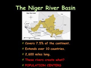
3) Key rivers that flow through Africa include the Nile, Congo, Zambezi, and Niger rivers, which empty into surrounding bodies of water like the Mediterranean Sea, Atlantic Ocean, Indian Ocean, and Red Sea.