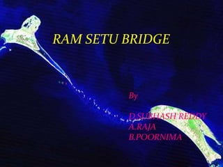
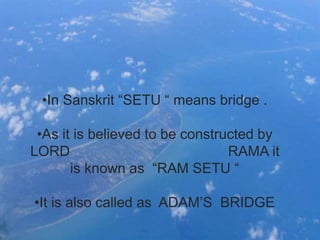
ENGLISH LANGUAGE AND
COMMUNICATION SKILLS
POWER POINT PRESENTATIION
RAM SETU BRIDGE
By
D.SUBHASH REDDY
A.RAJA
B.POORNIMA
WHAT IS RAM SETU?
•In Sanskrit “SETU “ means bridge .
•As it is believed to be constructed by
LORD RAMA it
is known as “RAM SETU “
•It is also called as ADAM’S BRIDGE
•It is situated between Pamban
Island and the north western coast
of Sri Lanka.
•Geological evidence suggests that
this bridge is a former land
connection between India and Sri
Lanka.
•The bridge is about 18 miles.
NASA images showing the
bridge
•Some of the sandbanks are dry and
the sea in the area is very shallow,
being only 3 ft to 30 ft (1 m to 10 m)
deep in places, which hinders
navigation.
•It was reportedly passable on foot up
to the 15th century until storms
deepened the channel: temple records
seem to say that Rama’s Bridge was
completely above sea level until it
broke in a cyclone in AD 1480
Historical significance of
Ram Setu
Malabar Bowen map (1747) drawn by Netherlands shows
Ramarcoil I (that is, Rama temple).
Ram Setu cited in map drawn by Joseph
Parks, Australian Botanical explorer (1788)
(Map in Sarasvati Mahal Lib., Thanjavur)
Problems being faced
due to Ram Setu
Ram Setu Bridge
Ram Setu Bridge
Ram Setu Bridge
Ram Setu Bridge

Ram Setu Bridge

  • 1.
    ENGLISH LANGUAGE AND COMMUNICATIONSKILLS POWER POINT PRESENTATIION
  • 2.
    RAM SETU BRIDGE By D.SUBHASHREDDY A.RAJA B.POORNIMA
  • 3.
  • 4.
    •In Sanskrit “SETU“ means bridge . •As it is believed to be constructed by LORD RAMA it is known as “RAM SETU “ •It is also called as ADAM’S BRIDGE
  • 5.
    •It is situatedbetween Pamban Island and the north western coast of Sri Lanka. •Geological evidence suggests that this bridge is a former land connection between India and Sri Lanka. •The bridge is about 18 miles.
  • 6.
  • 7.
    •Some of thesandbanks are dry and the sea in the area is very shallow, being only 3 ft to 30 ft (1 m to 10 m) deep in places, which hinders navigation. •It was reportedly passable on foot up to the 15th century until storms deepened the channel: temple records seem to say that Rama’s Bridge was completely above sea level until it broke in a cyclone in AD 1480
  • 8.
  • 12.
    Malabar Bowen map(1747) drawn by Netherlands shows Ramarcoil I (that is, Rama temple).
  • 13.
    Ram Setu citedin map drawn by Joseph Parks, Australian Botanical explorer (1788) (Map in Sarasvati Mahal Lib., Thanjavur)
  • 14.