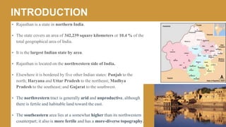
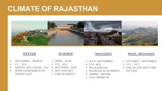
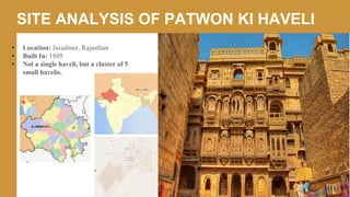
a study on the architecture and climate of hot and dry of Rajasthan specifically focusing on its vernacular architecture, its elements, materials, and a site analysis on patwon ki haveli
Rajasthan is the largest state in India by area. It encompasses most of the Thar Desert and shares borders with several other Indian states as well as Pakistan. Rajasthan has a population of over 68 million and its economy is primarily based on agriculture, with wheat, barley and other crops being important. The state contains several national parks and wildlife sanctuaries that are home to endangered species such as the Great Indian Bustard.
Tourism of Rajasthan is calling you "Padharo mhare desh..."
Rajasthan, the land of Kings, narrates the story of warriors, and their chivalry, glory and romance. The magical Rajasthan tourism gives tourists an opportunity to explore its unique heritage, colourful culture, thrilling desert safaris, glistening sand-dunes, lush forests and exotic wildlife. Rajasthan is simply an amazing tourist destination.
The document provides an overview of Rajasthan, India. It discusses the state's geography, noting that Rajasthan is the largest state and has Jaipur as its capital. The document then covers Rajasthan's history from the Indus Valley Civilization to its formation in 1949. It also summarizes Rajasthan's economy, noting agriculture and tourism as key industries. The document concludes with brief discussions of Rajasthani culture, fairs and festivals, and prominent historical leaders.
The document provides background information on the Indian state of Rajasthan. It discusses the region's history under various empires and invaders. It then summarizes Rajasthan's geography, demographics, culture, wildlife, transportation, and famous forts. The state has a mainly rural population and is known for its deserts, folk culture, handicrafts, and historic fortresses.
The document lists the states and union territories of India along with their capitals, governors, and chief ministers. There are 29 states and 7 union territories. For each state/territory, the capital, current governor, and current chief minister are provided. The states and territories span the country from Jammu and Kashmir in the north to Tamil Nadu in the south.
Roorkee is a city placed in Uttarakhand. According to reports, the city of Roorkee in the year 2011 is 118,200. The male and female population is 63,434 and 54,766 individually. The population density of Roorkee is 14,575 persons per square kilometer. For more info... https://indiapopulation2019.com/population-of-roorkee-2019.html
This document provides an overview of textiles and fashion in Pakistan. It discusses the country's provinces including Sindh, Punjab, Northwest Frontier, and Balochistan. It describes traditional Pakistani clothing like the shalwar kameez and details textile traditions such as embroidery, quilting, block printing, tie dye, and weaving. It also mentions the Fashion Design Council of Pakistan and its efforts to promote fashion weeks in Lahore and Karachi.
Among the fast developing states of Chhattisgarh is one of the fastest growing states in India. In every district there are plenty of beautiful places which offer beautiful landscape, eye soothing waterfalls and sanctuaries.
Source(s): http://WWW.apnachhattisgarh.in
This document discusses the culture, folklore, and traditions of Rajasthan, India. It covers the various dialects, cuisines, ballads, myths, folktales, legends, musical instruments, dances, dramas, tribes, festivals, deities, art, and efforts to preserve the folklore. The culture is deeply influenced by the state's history, geography, and people. Efforts are being made by various institutes to protect and promote Rajasthan's rich cultural heritage.
Among the fast developing states of Chhattisgarh is one of the fastest growing states in India.
In every district there are plenty of beautiful places which offer beautiful landscape, eye soothing waterfalls and sanctuaries.
Source(s): http://apnAchhattisgarh.in
Rajasthan is known for its vibrant culture, heritage, and natural beauty. Some of its main attractions include the colorful cities of Jaipur, Jodhpur, and Udaipur; desert landscapes in Jaisalmer and Bikaner; wildlife reserves like Ranthambore; and historic forts like Chittorgarh. Rajasthan is also culturally rich, with unique folk music, dances, festivals, and cuisine. Tourism is an important part of the state's economy, and the Rajasthan Tourism Development Corporation works to promote sustainable tourism.
Rajasthan is the largest state in India by area. It has a rich history and culture as evidenced by its many forts and palaces. Some significant festivals in Rajasthan include the Pushkar Camel Fair, Karni Mata Fair, and Gangaur Festival. Rajasthani cuisine is known for being hardy and flavorful using ingredients like coconut, chilies, and vinegar. The state has several national parks and wildlife sanctuaries that are home to species like the tiger and great Indian bustard.
This document provides an overview of the history, geography, people, culture, and administration of the state of Rajasthan, India. It discusses the various Rajput clans that ruled parts of Rajasthan from 700 AD. It then summarizes the medieval and modern periods of Rajasthan's history under Muslim and British rule. The document also describes the geography, climate, population, languages, religions, festivals, cuisine, costumes, and arts of Rajasthan. It concludes with information about the state's current administrative divisions and government institutions.
Pakistan has diverse physical features that include mountain ranges such as the Himalayas, Karakoram, Hindu Kush, and Sulaiman ranges, as well as plateaus and plains. Major rivers include the Indus River and its tributaries. Coastal areas along the Arabian Sea include the Indus River Delta. Pakistan has a population of over 204 million people, with high population growth and nearly 40% living in urban areas concentrated in cities like Karachi. The population is young, with over 30% under age 15.
land and physical features of Pakistan in detail.
>physical map of Pakistan.
>location of Pakistan
> altitude and neighboring countries.
> provinces and physical division of Pakistan.
>mountains, plains, deserts, salt range and plateaus.
> natural diversity
> river, seas, valleys, agriculture and Seasons of Pakistan .
Current Situation of Tourism Industry in Pakistan. Heavenly places to visit in Pakistan, Types of Tourism, Role of Tourism Industry in Economic Sector of Pakistan and Causes of Decline of Tourism Industry in Pakistan.
Pakistan Geographical Location - Pakistan Strategic WorthFaHaD .H. NooR
Pakistan Geography Location Analysis
Final Presentation #UCP
Pakistan (/ˈpækɪstæn/ (About this sound listen) or /pɑːkɪˈstɑːn/ (About this sound listen); Urdu: پاکستان), officially the Islamic Republic of Pakistan (Urdu: اسلامی جمہوریہ پاکستان), is a country in South Asia and on junction of West Asia, Central Asia and East Asia. It is the fifth-most populous country with a population exceeding 207.77 million people.[17] In terms of area, it is the 33rd-largest country spanning 881,913 square kilometres (340,509 square miles). Pakistan has a 1,046-kilometre (650-mile) coastline along the Arabian Sea and its Gulf of Oman in the south and is bordered by India to the east, Afghanistan to the west, Iran to the southwest, and China in the far northeast, respectively. It is separated narrowly from Tajikistan by Afghanistan's Wakhan Corridor in the north-west, and also shares a maritime border with Oman.
The territory that constitutes Pakistan is considered a cradle of civilisation[24][25][26][27][28] that was previously home to several ancient cultures, including the Mehrgarh of the Neolithic and the Bronze Age Indus Valley Civilisation, and later home to kingdoms ruled by people of different faiths and cultures, including Hindus, Indo-Greeks, Muslims, Turco-Mongols, Afghans, and Sikhs. The area has been ruled by numerous empires and dynasties, including the Persian Achaemenid Empire, Alexander III of Macedon, the Indian Mauryan Empire, the Arab Umayyad Caliphate, the Delhi Sultanate, the Mongol Empire, the Mughal Empire, the Afghan Durrani Empire, the Sikh Empire (partially), and most recently, the British Empire.
Pakistan is unique among Muslim countries in that it is the only country to have been created in the name of Islam.[29][30] As a result of the Pakistan Movement led by Muhammad Ali Jinnah and the subcontinent's struggle for independence, Pakistan was created in 1947 as an independent homeland for Indian Muslims.[31] It is an ethnically and linguistically diverse country, with a similarly diverse geography and wildlife. Initially a dominion, Pakistan adopted a constitution in 1956, becoming an Islamic republic. An ethnic civil war in 1971 resulted in the secession of East Pakistan as the new country of Bangladesh. In 1973 Pakistan adopted a new constitution establishing, alongside its pre-existing parliamentary republic status, a federal government based in Islamabad consisting of four provinces and four federal territories. The new constitution also stipulated that all laws were to conform to the injunctions of Islam as laid down in the Quran and Sunnah.[32]
Travel & Tourism Industry / Marketing Mix of Rajasthan Tousism / 7 Ps of Raja...Akshay Jain
The document discusses the travel and tourism industry, with a focus on tourism in India and Rajasthan. Some key points:
- Travel and tourism is the largest civilian industry worldwide, accounting for 9.6% of India's GDP. Foreign tourist arrivals in India were 8.8 million in 2016.
- Rajasthan tourism offers destinations like forts, palaces, festivals and fairs. Products and services include tours, the Palace on Wheels train, and aircraft charters.
- The 7Ps of tourism marketing discussed are place, product, price, promotion, people, process and physical evidence. Rajasthan tourism promotes through advertisements, social media and tour packages.
Pakistan has diverse physical features including mountains, plains, plateaus and deserts. The northern mountains include the Karakoram, Himalaya, and Hindu Kush ranges. The Indus plains make up 20% of Pakistan and are divided into upper, lower, and deltaic plains. Pakistan also contains the Thar desert in the southeast, Thal desert between the Indus and Jhelum rivers, and the Baluchistan plateau in the southwest. Major mountain ranges, rivers, and agricultural regions define Pakistan's varied terrain.
This document discusses leadership skills and qualities, using King Leonidas of Sparta as an example. It outlines Leonidas' leadership in the Battle of Thermopylae against the Persian army, noting his integrity, passion for his people, and willingness to sacrifice. It also describes characteristics of charismatic leaders like vision, personal risk-taking, sensitivity to followers, and unconventional behavior. Additionally, it lists important leadership skills such as strategic thinking, motivation, communication, learning, adaptability, and organization. Finally, it discusses situational leadership and different leadership styles appropriate for followers with high or low competence and commitment.
40.Physical features of pakistan A Lecture By Mr Allah Dad Khan Mr.Allah Dad Khan
The document discusses two deserts in Pakistan:
1. The Thar Desert is located in southeastern Sindh province and southeastern Punjab province. It is the 17th largest desert in the world and is surrounded by the Satluj River.
2. The Thal Desert is located in Punjab province between the Sindh and Jhelum rivers, near the Pothohar Plateau. It stretches 190 miles north to south and 70 miles east to west. The Thal Desert contains several towns and villages and has poor educational services, especially for females.
Rajasthan is known for its rich culture and heritage. It has a long history and was previously known as Rajputana. Rajasthan is located in western India and shares borders with several other states. It is a popular tourist destination, known for its forts, palaces, festivals, and traditional arts and crafts. Some of the major attractions include Meherangarh Fort, Umaid Bhawan Palace, and Lake Palace in Udaipur. The state takes pride in preserving its ancient traditions through music, dance, cuisine, and attire that trace back to the Rajput clans who have historically inhabited the region.
This document provides an overview of Pakistan, including its geography, climate, agriculture, and cultural relationships with China. It notes that Pakistan has diverse terrain including northern highlands, the Indus plain, and deserts. The country's geography has both traditional and modern geopolitical importance. Agriculture, especially wheat, rice, cotton, and sugarcane, is a key part of Pakistan's economy. The document also discusses Pakistan gaining independence in 1947 and establishing diplomatic relations with China in 1950 and 1951.
Pakistan has many beautiful valleys, mountain ranges, glaciers, rivers and deserts that provide scenic beauty and tourism opportunities. Some of the major valleys discussed in the document include the Swat, Rama, Kaghan, Naran, Gilgit, Hunza and Palas valleys. The document also describes several mountain ranges like the Himalayas and Hindukush and mountain passes like Khyber, Bolan and Karakoram that connect Pakistan with other countries. Significant glaciers, rivers and deserts of Pakistan are also outlined.
Harappa, Taxila, and Rohtas Fort are some of the most significant historical places in Pakistan that signify the unique tradition and culture of the country. Harappa is an archaeological site from the Harappa civilization in Punjab near Sahiwal. Taxila is also an important archaeological site located near Islamabad that was a center of learning. Rohtas Fort, built in the 16th century, is a historic fortress located near Jhelum that was constructed to suppress local tribes.
This document provides an overview of the geography of Pakistan. It discusses the country's provinces and special areas, as well as its major cities and regions. Pakistan has diverse terrain that includes mountains, deserts, and fertile plains watered by rivers like the Indus. The document outlines Pakistan's climate, agriculture, transportation infrastructure, energy resources, and international borders. In summary, it covers the key physical features and administrative divisions of Pakistan's landscape.
Madhya Pradesh is a state located in central India. Some key points:
- The state's capital is Bhopal, and it borders several other states. Several ancient tribal groups still reside in Madhya Pradesh.
- Important historical and religious sites include the Sanchi Stupa, which contains some of the oldest stone Buddhist structures in India, and forts like Gwalior Fort and Mandu Fort.
- The population is predominantly Hindu, and the state contains examples of vernacular architecture ranging from rural farmhouses to fort residences of former rulers.
Class 5 Subject - EVS, CH - Our India - Physical DiversityVista's Learning
This document provides an overview of the physical geography and features of India. It describes the major physical regions of India, including the Northern Mountains (Himalayas), Northern Plains, Peninsular Plateau, and Coastal Plains. For each region, it outlines the geographic characteristics, major rivers, climate, vegetation, and how the natural environment has influenced human settlement patterns and way of life. The document uses maps and diagrams to illustrate the various mountain ranges, plateaus, plains, and river systems that make up India's diverse physical landscape.
Pakistan has a diverse geography due to its location between major mountain ranges, rivers, and deserts. It has several physiographic regions including the Indus river plain, Balochistan plateau, Potwar plateau, Salt range, and Thar desert. Pakistan also has significant natural resources like agricultural land suitable for crops, and reserves of coal, natural gas, salt, gold, and other minerals. The climate varies regionally from tropical to temperate depending on elevation.
Here is another creative presentation by your slide maker on the topic “South India".
Hope you like it. If you like it then please, *like*, *Download* and *Share*. By- Slide_maker4u (Abhishek Sharma) *******For presentation Orders, contact me on the Email addresses Written below******** Email- Sharmaabhishek576@gmail.com or Sharmacomputers87@gmail.com *******THANK YOU***************
peninsula plateau made by yash chauhanYash Chauhan
The document summarizes the key physical features of the Deccan Plateau and Central Highlands of India. It describes the Deccan Plateau as a large triangular plateau covering most of southern India, rising from 100 meters to over 1 kilometer in elevation. It notes that the Central Highlands region lies to the north of the Vindhya Range and includes areas like the Malwa Plateau, Bundelkhand, and Chota Nagpur Plateau. The document also provides brief descriptions of the Western Ghats and Eastern Ghats, which form the edges of the Deccan Plateau.
India is one of the oldest civilizations in the world located in South Asia between latitudes 8°4'N and 37°6'N and longitudes 68°7'E and 97°25'E. It has an area of 3.28 million square km and shares land borders with Pakistan, Afghanistan, China, Nepal, Bhutan, Bangladesh and Myanmar. India has achieved significant progress in agriculture, industry, technology and economic development over the last five decades while maintaining relationships with its neighbors through historical and geographical ties.
Orissa has abundant natural resources including water, land, forests, and minerals. Its water resources include several major rivers like the Mahanadi that flow across the state and empty into the Bay of Bengal. The state has forests covering 32% of its area that contain valuable trees. Orissa also has significant mineral resources such as iron ore, manganese, chromite, bauxite, limestone, and coal deposits that make it a major producer for industries. The state utilizes its water and land resources for irrigation, hydroelectricity, and agriculture.
The document summarizes the structure and physiography of India. It divides India into several physiographic divisions based on geological structure and landforms: the Himalayas, Northern Plains, Peninsular Plateau, Indian Desert, Coastal Plains, and Islands. It describes the key features of each division, including their positioning, formation processes, and distinguishing characteristics. The Islands are further divided into Andaman and Nicobar Islands and Lakshadweep Islands, with details provided on each group.
The coastal plains of India are located along both the eastern and western coasts. The eastern coastal plains stretch along the Bay of Bengal from Tamil Nadu to West Bengal. They are divided into six regions including the Mahanadi Delta and Coromandel Coast. The western coastal plains run along the Arabian Sea from Gujarat to Kerala in a narrow strip. They are divided into three regions: Konkan, Kanara, and the Malabar Coast, characterized by backwaters and estuaries.
India is located in Southern Asia between latitudes 8°4'N and 37°6'N and longitudes 68°7'E and 97°25’E. It has a total land area of 3.28 million square kilometers, making it the 7th largest country by area. India shares land borders with Pakistan, Afghanistan, China, Nepal, Bhutan, Bangladesh and Myanmar. The Indian subcontinent extends southward into the Indian Ocean with coastal lines on the Arabian Sea and Bay of Bengal. India has a long history of interaction and cultural exchange with its neighbors and other parts of the world through both land and maritime trade routes.
1. India is located in South Asia between latitudes 8°4'N and 37°6'N and longitudes 68°7'E and 97°25'E. It has a total land area of 3.28 million sq km and coastline of 15,200 km.
2. India's physical features were formed by the movement of tectonic plates over millions of years and include the Himalayan Mountains, Northern Plains, Peninsular Plateau, Indian Desert, and Coastal Plains.
3. The Himalayas contain the highest peaks in India and extend across the northern borders. The Peninsular Plateau includes the Deccan Plateau and Western and Eastern G
Srirangam is an island town in Tamil Nadu, India with a population of over 2 million people. It is home to the Srirangam Temple complex which covers an area of 6.79 million square feet and has 21 towers, making it the largest functioning Hindu temple in the world. The town developed around the temple, with residential areas arranged in concentric circles based on caste. The temple remains the economic and cultural center of Srirangam, drawing over 7 million visitors annually.
The document provides information about South India. It states that South India comprises the states of Andhra Pradesh, Karnataka, Telangana, Tamil Nadu and Kerala. The major rivers are the Godavari, Krishna, Tungabhadra, Kaveri and Vaigai. The largest cities are Chennai, Bengaluru, Hyderabad, Visakhapatnam, Coimbatore, Kochi and Thiruvananthapuram. South India has a long independent literary and cultural tradition dating back over 2500 years including ancient Tamil literature and architecture. It is also home to diverse religious communities including Christians, Jews and Muslims with a long history in the region.
The document provides information about South India. It states that South India comprises the states of Andhra Pradesh, Karnataka, Telangana, Tamil Nadu and Kerala. The region has a long independent literary tradition dating back over 2500 years including ancient Tamil epics. It is known for its diverse architecture, heritage sites, and festivals celebrated throughout the year. The climate varies across states from tropical to cooler temperatures. Major cities in the region include Chennai, Bengaluru, Hyderabad and Kochi.
The case study is about the india's most well planned city that is Jaipur, Rajasthan. what is the urban sprawl in that city and how it grows that will expained in that.
The document discusses the Chola dynasty of South India between the 10th-12th centuries CE. It summarizes that the Cholas rose to power under kings Rajaraja I and Rajendra I, who expanded their control across South India and Sri Lanka. It highlights that the Cholas left behind many inscriptions and temples, most notably the Brihadeeswarar Temple built by Rajaraja I, which provide historical information about the Chola administration, taxation systems, and cultural achievements.
Geography Project on Geography Physics.pptxtechnoteerth09
This document provides information about the location, extent, political and physical divisions of India. It discusses that India is located in South Asia between latitudes 8°4' N and 37°6' N and longitudes 68°7'E and 97°25'E. India has a total area of about 3.28 million square kilometers and shares land borders with 7 countries. The country is divided into 28 states and 8 union territories for administrative purposes. Physically, India contains various regions including the Northern Mountains, Northern Plains, Peninsular Plateau, Indian Desert, Coastal Plains and Islands.
This document provides an overview of the physical geography of Asia. It discusses several key topics:
- Asia contains one-third of the world's land area and over 60% of the global population, with most people living in rural areas.
- Major physical features include mountain ranges like the Himalayas and Tien Shan, rivers including the Ganges and Yangtze, and deserts such as the Gobi and Thar.
- Climate varies significantly from region to region, with extreme cold in Siberia and heavy monsoon rains across South and Southeast Asia. Common biomes include taiga, steppe, and tropical rainforests.
- Major crops include rice, wheat, sugarcane, tea
Pakistan has many natural resources that are important for its development, including soil, mountains, rivers, forests, animals, and minerals. Soil provides fertile land for agriculture. Mountains contain valuable minerals and provide water to rivers. Rivers such as the Indus are crucial for irrigation, drinking water, and hydroelectric power. Forests regulate weather and flooding. Animals supply meat, milk and other products. Minerals such as coal, natural gas, iron ore, and chromite fuel industry and power generation. However, Pakistan only allocates a small portion of its budget, around 0.45-2.46%, toward developing its mineral industry despite minerals contributing around 0.5% to the country's GDP.
Elevate Your Nonprofit's Online Presence_ A Guide to Effective SEO Strategies...TechSoup
Whether you're new to SEO or looking to refine your existing strategies, this webinar will provide you with actionable insights and practical tips to elevate your nonprofit's online presence.
Gender and Mental Health - Counselling and Family Therapy Applications and In...PsychoTech Services
A proprietary approach developed by bringing together the best of learning theories from Psychology, design principles from the world of visualization, and pedagogical methods from over a decade of training experience, that enables you to: Learn better, faster!
🔥🔥🔥🔥🔥🔥🔥🔥🔥
إضغ بين إيديكم من أقوى الملازم التي صممتها
ملزمة تشريح الجهاز الهيكلي (نظري 3)
💀💀💀💀💀💀💀💀💀💀
تتميز هذهِ الملزمة بعِدة مُميزات :
1- مُترجمة ترجمة تُناسب جميع المستويات
2- تحتوي على 78 رسم توضيحي لكل كلمة موجودة بالملزمة (لكل كلمة !!!!)
#فهم_ماكو_درخ
3- دقة الكتابة والصور عالية جداً جداً جداً
4- هُنالك بعض المعلومات تم توضيحها بشكل تفصيلي جداً (تُعتبر لدى الطالب أو الطالبة بإنها معلومات مُبهمة ومع ذلك تم توضيح هذهِ المعلومات المُبهمة بشكل تفصيلي جداً
5- الملزمة تشرح نفسها ب نفسها بس تكلك تعال اقراني
6- تحتوي الملزمة في اول سلايد على خارطة تتضمن جميع تفرُعات معلومات الجهاز الهيكلي المذكورة في هذهِ الملزمة
واخيراً هذهِ الملزمة حلالٌ عليكم وإتمنى منكم إن تدعولي بالخير والصحة والعافية فقط
كل التوفيق زملائي وزميلاتي ، زميلكم محمد الذهبي 💊💊
🔥🔥🔥🔥🔥🔥🔥🔥🔥
THE SACRIFICE HOW PRO-PALESTINE PROTESTS STUDENTS ARE SACRIFICING TO CHANGE T...indexPub
The recent surge in pro-Palestine student activism has prompted significant responses from universities, ranging from negotiations and divestment commitments to increased transparency about investments in companies supporting the war on Gaza. This activism has led to the cessation of student encampments but also highlighted the substantial sacrifices made by students, including academic disruptions and personal risks. The primary drivers of these protests are poor university administration, lack of transparency, and inadequate communication between officials and students. This study examines the profound emotional, psychological, and professional impacts on students engaged in pro-Palestine protests, focusing on Generation Z's (Gen-Z) activism dynamics. This paper explores the significant sacrifices made by these students and even the professors supporting the pro-Palestine movement, with a focus on recent global movements. Through an in-depth analysis of printed and electronic media, the study examines the impacts of these sacrifices on the academic and personal lives of those involved. The paper highlights examples from various universities, demonstrating student activism's long-term and short-term effects, including disciplinary actions, social backlash, and career implications. The researchers also explore the broader implications of student sacrifices. The findings reveal that these sacrifices are driven by a profound commitment to justice and human rights, and are influenced by the increasing availability of information, peer interactions, and personal convictions. The study also discusses the broader implications of this activism, comparing it to historical precedents and assessing its potential to influence policy and public opinion. The emotional and psychological toll on student activists is significant, but their sense of purpose and community support mitigates some of these challenges. However, the researchers call for acknowledging the broader Impact of these sacrifices on the future global movement of FreePalestine.
How to Download & Install Module From the Odoo App Store in Odoo 17Celine George
Custom modules offer the flexibility to extend Odoo's capabilities, address unique requirements, and optimize workflows to align seamlessly with your organization's processes. By leveraging custom modules, businesses can unlock greater efficiency, productivity, and innovation, empowering them to stay competitive in today's dynamic market landscape. In this tutorial, we'll guide you step by step on how to easily download and install modules from the Odoo App Store.
Andreas Schleicher presents PISA 2022 Volume III - Creative Thinking - 18 Jun...EduSkills OECD
Andreas Schleicher, Director of Education and Skills at the OECD presents at the launch of PISA 2022 Volume III - Creative Minds, Creative Schools on 18 June 2024.
This document provides an overview of wound healing, its functions, stages, mechanisms, factors affecting it, and complications.
A wound is a break in the integrity of the skin or tissues, which may be associated with disruption of the structure and function.
Healing is the body’s response to injury in an attempt to restore normal structure and functions.
Healing can occur in two ways: Regeneration and Repair
There are 4 phases of wound healing: hemostasis, inflammation, proliferation, and remodeling. This document also describes the mechanism of wound healing. Factors that affect healing include infection, uncontrolled diabetes, poor nutrition, age, anemia, the presence of foreign bodies, etc.
Complications of wound healing like infection, hyperpigmentation of scar, contractures, and keloid formation.
2. • Rajasthan is a state in northern India.
• The state covers an area of 342,239 square kilometers or 10.4 % of the
total geographical area of India.
• It is the largest Indian state by area.
• Rajasthan is located on the northwestern side of India.
• Elsewhere it is bordered by five other Indian states: Punjab to the
north; Haryana and Uttar Pradesh to the northeast; Madhya
Pradesh to the southeast; and Gujarat to the southwest.
• The northwestern tract is generally arid and unproductive, although
there is fertile and habitable land toward the east.
• The southeastern area lies at a somewhat higher than its northwestern
counterpart; it also is more fertile and has a more-diverse topography.
INTRODUCTION
3. CLIMATE OF RAJASTHAN
WINTER
• DECEMBER – MARCH
• 4 C – 28 C
• MOUNT ABU, CHURU – 0 C
• WIND FROM NORTH TO
NORTH EAST
SUMMER
• APRIL - JUNE
• 32 C – 46 C
• HOT WIND – LOO
• HOT AND DRY
• LOW HUMIDITY
MONSOON
• JULY- SEPTEMBER
• 35 C- 40 C
• 90% RAINFALL
• INCREASE IN HUMIDITY
• 200MM – 400 MM
• AVG 100MM/YR
POST- MONSOON
• OCTOBER – NOVEMBER
• 33 C – 38 C
• ONE OF THE BEST TIME
TO VISIT
4. VERNACULAR ARCHITECTURE
• “The Golden City”: The town stands on a ridge of
yellowish sandstone, crowned by forts, which
contains the palace and several Jain temples.
• In Indian architecture there are features like
pavilions, courtyards, terraces,
• All these come together to articulate the space. To
these new room are also added. These structure
can also be a part of temple, palaces, ghat and
institutional buildings.
• They use Golden stone for consruction, which is
soft hence carvings can be done easily.
• They do not use mortar.
7. SITE ANALYSIS OF PATWON KI HAVELI
• Location: Jaisalmer, Rajasthan
• Built In: 1805
• Not a single haveli, but a cluster of 5
small havelis.
8. SITE ANALYSIS OF PATWON KI HAVELI
• The heat inside of the building is controlled by
the use of textures in Jaisalmer.
• The building facades have large number
of projections like jharokhas and chajjas which
provide shade to the facades.
• Traditional layouts essentially promoted airflow
within and around buildings.