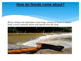
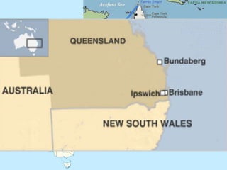
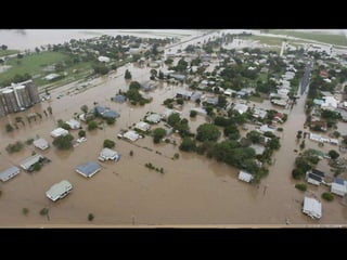
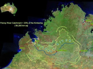
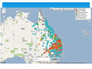
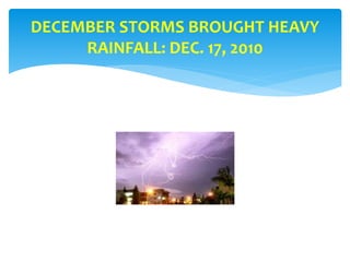
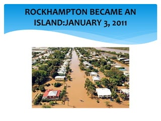
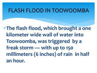
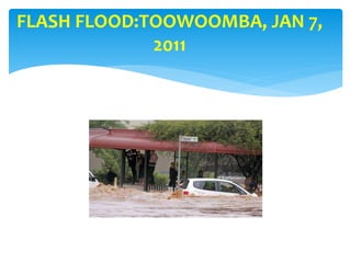
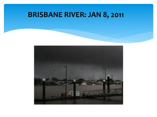
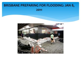
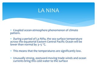
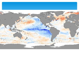
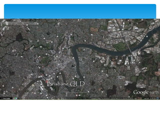
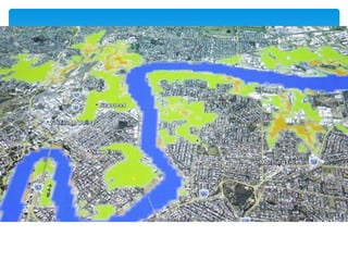
 Introduction
 Basic Facts
 Further Facts and Figures
 Destruction and Damage
 Action
 Effects
 Causes
 Result
CONTENTS
 Where: Queensland, Australia
 River: Fitzroy and Brunette rivers
 Period of the flood: couple of months
 Dec 2010 to january 2011
What, when and where
GREAT QUEENSLAND FLOOD
INUNDATES 22 TOWNS, DISPLACES
200,000, KILLS 20 +, AND CAUSES
LOSSES OF OVER $5 BILLION IN
AUSTRALIA
Heavy storms can sometimes cause huge volumes of water to depart
from a river's natural course and spread over dry land.
How do floods come about?
75 PERCENT OF QUEENSLAND
STATE DECLARED A DISASTER
ZONE
RECORD FLOODING IN AUSTRALIA:
NEW SOUTH WALES
ROCKHAMPTON
TOOWOOMBA
BRISBANE
DECEMBER 10 – JANUARY ?, 2011
Extent of the flood
Damage and Destruction
THE FIRST PHASE OF RECORD
FLOODING BEGAN IN
DECEMBER
DECEMBER 10, 2010
DECEMBER STORMS BROUGHT HEAVY
RAINFALL: DEC. 17, 2010
TOWN OF THEODORE: FLOODED
THE SECOND PHASE OF
FLOODING HAPPENED IN
JANUARY
AN AREA OF FLOODING THE SIZE OF FRANCE AND GERMANY (OR, TEXAS
AND NEW MEXICO) COMBINED WAS CREATED IN QUEENSLAND
Rockhampton, a town of
77,000 people 370 miles north
of Brisbane, lies close to the
coast, on the Fitzroy, one of
Australia's largest river
systems.
ROCKHAMPTON HIT HARD
ROCKHAMPTON BECAME AN
ISLAND:JANUARY 3, 2011
All main routes to the south, north
and west of the city were cut off
by the rising water, rail lines and
the airport runways were
submerged, and floodwaters
stretched for several miles in each
direction.
ROCKHAMPTON HIT HARD
FITZROY RIVER STILL RISING:
JANUARY 3, 2011
TRADITIONAL SANDBAGGING HAD
LIMITED VALUE
FITZROY RIVER PEAKED AT 9.2 M:
JANUARY 6, 2011
THE THIRD PHASE OF FLOODING
WAS TRIGGERED BY A FLASH
FLOOD
JANUARY 11, 2011
The flash flood, which brought a one
kilometer wide wall of water into
Toowoomba, was triggered by a
freak storm — with up to 150
millimeters (6 inches) of rain in half
an hour.
FLASH FLOOD IN TOOWOOMBA
Cars were transformed into “boats”
and became scrap metal as they
collided with infrastructure; giant
metal industrial bins were tossed
about as if made of paper; and
houses were torn off foundations.
FLASH FLOOD:TOOWOOMBA, JAN 7,
2011
THE FOURTH PHASE OF
FLOODING BEGINS IN BRISBANE
JANUARY 11 AND FOLLOWING
BRISBANE RIVER: JAN 8, 2011
BRISBANE PREPARING FOR FLOODING: JAN 8,
2011
The city is protected by a large dam
built upstream after floods
devastated the downtown in 1974,
but the reservoir was full, so officials
had no choice but to release water,
which caused flooding before the
“FLOOD”.
BRISBANE
MORE than 50 suburbs were flooded
as the Brisbane River rose to 4.5 m or
more above flood stage, with some
areas being completely inundated.
BRISBANE
BRISBANE FLOODING: JAN 11, 2011
BRISBANE RIVER CRESTED AT 4.46 M: JAN
12, 2011
 35 people dead.
 In Ipswich 350 homes
 Cattle, sheep and goats lost.
 200,00 people are without power
 6,000 homes are without power in the north.
 Thousands of hectors of Agricultural land lost.
 Most affected were residents of the Lockyer Valley
 Town of Gympie cut off and dozens of businesses were underwater.
 The rain was brought by Tropical Cyclone Oswald, affecting the N. part of New South Wales.
 Initial estimation at around A$1 billion
 Raised to $2.38 billion.
 Finally $5.6 billion
 Reduction in Australia's GDP A$40 billion.
Monetary damage
 $14.8m for Inquiry, "forensically examine" the chain of events.
 "I see this as an investment in our future safety, an investment in
being better prepared for an event like this in the future,"
 "This is very big. It's not just something which is going to occupy
our time for the next few months. It will be a question of years
as we go through the rebuilding."
 The floods have been blamed on the La Nina weather pattern in
the Pacific.
Action
.
A difficult situation was made even
more so by thunderstorms, high
winds, raging rivers, and driving rain
that made it very hard for
helicopters and boats to reach and
rescue flood victims.
EMERGENCY SERVICES
Queensland's raw coal
production declined by
more one third in late
2010 and was slow to
recover. Coal railway
lines were closed and
numerous mine sites
flooded.
--------------------------------
• On 8 July 2014
• firm Maurice Blackburn
• class action with the NSW Supreme Court
• On behalf of 4000 flood victims.
• dams:
• Seqwater,
• SunWater
• the State of Queensland.
Legal Action
DISASTER & HAZARD
INFORMATION SYSTEMS
TECHNIQUES
AND
TECHNOLOGIES
ACADEMIA
FUNCTIONAL
NETWORKING
CHANNELS
INFORMATION
NETWORKING
CHANNELS
ORGANIZATION
NETWORKING
CHANNELS
COLLABORATION
COMMUNITY STAKEHOLDERS
Stratec Consulting
CAUSES OF THE FLOOD
 Coupled ocean-atmosphere phenomenon of climate
pattern.
 During a period of La Niña, the sea surface temperature
across the equatorial Eastern Central Pacific Ocean will be
lower than normal by 3–5 °C.
 This means that the temperatures are significantly low.
 Unusually strong, eastward-moving trade winds and ocean
currents bring this cold water to the surface
LA NINA
Urbanization
Human causes for the flood
Natural causes of the flood
Positive effect
Negative effect
The local wildlife was caught off-
guard by the flooding; bewildered
and hungry kangaroos moved to
high ground, and cattle were left
lost and confused by the excessive
water that inundated everything.
WILDLIFE AFFECTED
 It was a considered a hundred year flood, floods of
this extent had occurred in 1893 and 1974.
 Another affect of Global warming.
 Catastrophe can be avoided by collaboration.
results
AFTERMATH
 Long term  Short term
 BBC: http://www.bbc.com/
 ABC: http://abcnews.go.com/
 http://masey.co/2011/01/2011-queensland-floods-big-wet/#ixzz44ZQWXMfN
 http://www.couriermail.com.au
 differences by: https://services.land.vic.gov.au/floods/vic_floods_ok.htm
 Arial photograph http://resources3.news.com.au/images/2011/01/14/1225988/041111-grantham-flood.jpg
 BABY KANGROO: http://masey.co/wp-content/uploads/2013/11/2011-queensland-floods-the-big-wet.jpg
 Pictures: http://mapsof.net/uploads/static-maps/brisbane_river_map.png
 http://www.environskimberley.org.au/wp-content/uploads/2014/04/Fitzroy-map_0808_copyright-Ecomap-2006.jpg
 http://resources3.news.com.au/images/2013/01/21/1226558/296047-flood-maps.jpg
 https://media.apnarm.net.au/139.4/img/media/images/2011/01/13/map.jpg
 https://upload.wikimedia.org/wikipedia/commons/thumb/a/ac/Queensland_in_Australia.svg/2055px-
Queensland_in_Australia.svg.png
 http://wwp.greenwichmeantime.com/images/time/australia/queensland.jpg
 Presentation by biba?
 Presentation by Walter Hays, Global Alliance for Disaster Reduction, University of North Carolina, USA
Sources

Queensland flood, Australia

  • 2.
     Introduction  BasicFacts  Further Facts and Figures  Destruction and Damage  Action  Effects  Causes  Result CONTENTS
  • 3.
     Where: Queensland,Australia  River: Fitzroy and Brunette rivers  Period of the flood: couple of months  Dec 2010 to january 2011 What, when and where
  • 4.
    GREAT QUEENSLAND FLOOD INUNDATES22 TOWNS, DISPLACES 200,000, KILLS 20 +, AND CAUSES LOSSES OF OVER $5 BILLION IN AUSTRALIA
  • 5.
    Heavy storms cansometimes cause huge volumes of water to depart from a river's natural course and spread over dry land. How do floods come about?
  • 6.
    75 PERCENT OFQUEENSLAND STATE DECLARED A DISASTER ZONE
  • 7.
    RECORD FLOODING INAUSTRALIA: NEW SOUTH WALES ROCKHAMPTON TOOWOOMBA BRISBANE DECEMBER 10 – JANUARY ?, 2011
  • 11.
  • 12.
  • 14.
    THE FIRST PHASEOF RECORD FLOODING BEGAN IN DECEMBER DECEMBER 10, 2010
  • 15.
    DECEMBER STORMS BROUGHTHEAVY RAINFALL: DEC. 17, 2010
  • 16.
  • 17.
    THE SECOND PHASEOF FLOODING HAPPENED IN JANUARY AN AREA OF FLOODING THE SIZE OF FRANCE AND GERMANY (OR, TEXAS AND NEW MEXICO) COMBINED WAS CREATED IN QUEENSLAND
  • 18.
    Rockhampton, a townof 77,000 people 370 miles north of Brisbane, lies close to the coast, on the Fitzroy, one of Australia's largest river systems. ROCKHAMPTON HIT HARD
  • 19.
  • 20.
    All main routesto the south, north and west of the city were cut off by the rising water, rail lines and the airport runways were submerged, and floodwaters stretched for several miles in each direction. ROCKHAMPTON HIT HARD
  • 21.
    FITZROY RIVER STILLRISING: JANUARY 3, 2011
  • 22.
  • 23.
    FITZROY RIVER PEAKEDAT 9.2 M: JANUARY 6, 2011
  • 24.
    THE THIRD PHASEOF FLOODING WAS TRIGGERED BY A FLASH FLOOD JANUARY 11, 2011
  • 25.
    The flash flood,which brought a one kilometer wide wall of water into Toowoomba, was triggered by a freak storm — with up to 150 millimeters (6 inches) of rain in half an hour. FLASH FLOOD IN TOOWOOMBA
  • 26.
    Cars were transformedinto “boats” and became scrap metal as they collided with infrastructure; giant metal industrial bins were tossed about as if made of paper; and houses were torn off foundations.
  • 27.
  • 28.
    THE FOURTH PHASEOF FLOODING BEGINS IN BRISBANE JANUARY 11 AND FOLLOWING
  • 29.
  • 30.
    BRISBANE PREPARING FORFLOODING: JAN 8, 2011
  • 31.
    The city isprotected by a large dam built upstream after floods devastated the downtown in 1974, but the reservoir was full, so officials had no choice but to release water, which caused flooding before the “FLOOD”. BRISBANE
  • 32.
    MORE than 50suburbs were flooded as the Brisbane River rose to 4.5 m or more above flood stage, with some areas being completely inundated. BRISBANE
  • 33.
  • 34.
    BRISBANE RIVER CRESTEDAT 4.46 M: JAN 12, 2011
  • 35.
     35 peopledead.  In Ipswich 350 homes  Cattle, sheep and goats lost.  200,00 people are without power  6,000 homes are without power in the north.  Thousands of hectors of Agricultural land lost.  Most affected were residents of the Lockyer Valley  Town of Gympie cut off and dozens of businesses were underwater.  The rain was brought by Tropical Cyclone Oswald, affecting the N. part of New South Wales.
  • 36.
     Initial estimationat around A$1 billion  Raised to $2.38 billion.  Finally $5.6 billion  Reduction in Australia's GDP A$40 billion. Monetary damage
  • 38.
     $14.8m forInquiry, "forensically examine" the chain of events.  "I see this as an investment in our future safety, an investment in being better prepared for an event like this in the future,"  "This is very big. It's not just something which is going to occupy our time for the next few months. It will be a question of years as we go through the rebuilding."  The floods have been blamed on the La Nina weather pattern in the Pacific. Action
  • 39.
    . A difficult situationwas made even more so by thunderstorms, high winds, raging rivers, and driving rain that made it very hard for helicopters and boats to reach and rescue flood victims. EMERGENCY SERVICES
  • 40.
    Queensland's raw coal productiondeclined by more one third in late 2010 and was slow to recover. Coal railway lines were closed and numerous mine sites flooded. -------------------------------- • On 8 July 2014 • firm Maurice Blackburn • class action with the NSW Supreme Court • On behalf of 4000 flood victims. • dams: • Seqwater, • SunWater • the State of Queensland. Legal Action
  • 41.
    DISASTER & HAZARD INFORMATIONSYSTEMS TECHNIQUES AND TECHNOLOGIES ACADEMIA FUNCTIONAL NETWORKING CHANNELS INFORMATION NETWORKING CHANNELS ORGANIZATION NETWORKING CHANNELS COLLABORATION COMMUNITY STAKEHOLDERS Stratec Consulting
  • 42.
  • 43.
     Coupled ocean-atmospherephenomenon of climate pattern.  During a period of La Niña, the sea surface temperature across the equatorial Eastern Central Pacific Ocean will be lower than normal by 3–5 °C.  This means that the temperatures are significantly low.  Unusually strong, eastward-moving trade winds and ocean currents bring this cold water to the surface LA NINA
  • 45.
  • 49.
  • 50.
  • 51.
  • 52.
    The local wildlifewas caught off- guard by the flooding; bewildered and hungry kangaroos moved to high ground, and cattle were left lost and confused by the excessive water that inundated everything. WILDLIFE AFFECTED
  • 53.
     It wasa considered a hundred year flood, floods of this extent had occurred in 1893 and 1974.  Another affect of Global warming.  Catastrophe can be avoided by collaboration. results
  • 54.
  • 56.
     BBC: http://www.bbc.com/ ABC: http://abcnews.go.com/  http://masey.co/2011/01/2011-queensland-floods-big-wet/#ixzz44ZQWXMfN  http://www.couriermail.com.au  differences by: https://services.land.vic.gov.au/floods/vic_floods_ok.htm  Arial photograph http://resources3.news.com.au/images/2011/01/14/1225988/041111-grantham-flood.jpg  BABY KANGROO: http://masey.co/wp-content/uploads/2013/11/2011-queensland-floods-the-big-wet.jpg  Pictures: http://mapsof.net/uploads/static-maps/brisbane_river_map.png  http://www.environskimberley.org.au/wp-content/uploads/2014/04/Fitzroy-map_0808_copyright-Ecomap-2006.jpg  http://resources3.news.com.au/images/2013/01/21/1226558/296047-flood-maps.jpg  https://media.apnarm.net.au/139.4/img/media/images/2011/01/13/map.jpg  https://upload.wikimedia.org/wikipedia/commons/thumb/a/ac/Queensland_in_Australia.svg/2055px- Queensland_in_Australia.svg.png  http://wwp.greenwichmeantime.com/images/time/australia/queensland.jpg  Presentation by biba?  Presentation by Walter Hays, Global Alliance for Disaster Reduction, University of North Carolina, USA Sources

Editor's Notes

  • #7  Areas affected: Much of central and southern Queensland including Brisbane, Rockhampton, Emerald, Bundaburg, Dalby, Toowoomba and Ipswich.
  • #10 Last :AFTERMATH: Pictures of Grantham following the devastating January floods. A Senate committee last night found Queensland could never have had enough insurance to bank against the disaster happening
  • #11 This detailed astronaut photograph illustrates flooding in suburbs of the Brisbane metropolitan region.
  • #12 Communities along the Fitzroy and Burnett Rivers were particularly hard hit,   The Condamine, Ballone and Mary Rivers recorded substantial flooding.   An unexpected flash flood caused by a thunderstorm raced through Toowoomba's central business district.   Water from the same storm devastated communities in the Lockyer Valley.   A few days later thousands of houses in Ipswich and Brisbane were inundated as the Brisbane River rose and Wivenhoe Dam used a considerable proportion of its flood mitigation capacity. 
  • #14 "But we are a strong and smart nation and we'll get through this, as we always do, by pulling together,"
  • #36 The officials had warned of heavy rain, usually high tides and damaging winds, with gusts of up to 100 km/h (62 mph). Flash flood warnings have also been given.
  • #38 NASA image showing swollen rivers and cloud cover. Rockhampton seen from the air on 31 December; the Fitzroy River can be seen to have burst its banks
  • #39 'Better prepared' Flooding in the state displaced thousands, with damage initially estimated at AU$1bn (£650m). Heavy rains created a deadly inland flood that swept over Toowoomba last year without warning. The flooding has been described by state officials as the worst in decades. Many communities, including Brisbane, are still rebuilding a year on. Altogether the floods killed 35 people and damaged 30,000 homes and businesses.
  • #41 On 8 July 2014 legal firm Maurice Blackburn lodged a class action with the NSW Supreme Court on behalf of 4000 flood victims. The legal action alleges negligence and nuisance against the operators of the dams: Seqwater, SunWater and the State of Queensland.