presenter_mobilemapping_rail_HQ_print
•
0 likes•95 views

Mobile mapping technology allows for the collection of 3D geospatial data from a moving vehicle platform using satellite positioning and inertial measurement units. Severn Partnership has experience completing mobile mapping projects for the UK rail industry in compliance with relevant standards. A recent project involved using mobile mapping to survey a 3km section of the West Coast Mainline, mapping the cess area within 3m of the tracks. This allowed the work to be completed in a single weekend possession, reducing time on site compared to traditional survey methods. Quality checks confirmed the mobile mapping data matched existing survey control points to within project tolerances.

Recommended
More Related Content
What's hot
What's hot (7)
Viewers also liked
Viewers also liked (17)
Similar to presenter_mobilemapping_rail_HQ_print
Similar to presenter_mobilemapping_rail_HQ_print (20)
presenter_mobilemapping_rail_HQ_print
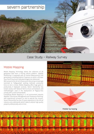
- 1. Case Study - Railway Survey Mobile Mapping Mobile Mapping Technology allows the collection of 3D geospatial data from a moving vehicle platform. Satellite Positioning is supported with an Inertial Measurement Unit generating a smoothed Vehicle Trajectory, to which a 3D laser Scan Point Cloud and Calibrated Imagery are referenced. With access to the UK rail infrastructure becoming increasingly restricted to ‘Safeguarded’ working methods, productive time on site is critical. Mobile Mapping offers huge gains in productivity if deployed correctly. Severn Partnership has liaised closely with Network Rail to ensure all hardware and methodologies used in the deployment of Pegasus:Two comply with current UK standards. Completing Mobile Mapping in a rail environment requires detailed ‘Track Access’ Management and ‘Possession Planning’ with experienced surveyors on site to execute the mission. Severn Partnership has over 25 years experience in the UK rail industry and understands what it takes to deliver high quality projects professionally and on time. Mobile Surveying
- 2. Overview A new cable route required detailed mapping of the Cess area within 3 metres of the running line, including OHLE Masts and overhead wires, for a distance of 3km along the West Coast Mainline. Traditional survey methods would utilise existing survey control in the form of Spigots on OHLE Masts and require 4 midweek night shifts to complete with 2 survey teams. Due to the proximity to running lines, a ‘Safeguarded’ working method would be required, using either ‘Line Blocks’ or a ‘Possession of the Line’. Each survey team would require their own COSS, bringing the total number of staff on site to 6 per shift; 24 site shifts for the project. A further 5 days of office processing would be required to produce final deliverables. Using Mobile Mapping allowed Severn Partnership to complete all site works in a single weekend ‘Possession of the Line’ with a 2 person survey team, requiring a COSS and Machine Operator as well. A total of 4 staff required on site; a reduction of 20 site shifts over traditional methods, reducing footfall in what is termed as a ‘Time Pressurised Safety Critical Environment’. Office processing also required 5 days to produce final deliverables. To ensure final deliverables were comparable with traditional methods the existing survey control spigots on OHLE masts were used as Quality Check points in the Lidar Point Cloud. Coordinates matched to within project tolerance of 20mm. In addition to significant time savings on site the client also received a high definition Lidar Point cloud and floodlit imagery of the site to aid in design works, adding value to their own deliverables. Deliverables • 3D CAD Vector Drawing • 3D Lidar Point Cloud • Georeferenced Floodlit Site Imagery – with free ArcGIS viewer plugin • All data delivered on WCML05 Snakegrid coordinate system De-Risk your Project Less time on site, recording more data with the backup of surveying twice in one go (Photogrammetry & LiDAR). Make sure you have all the data you need in the fastest, safest, most accurate way possible. Safe, Accurate, Efficient, Complete Data The Maltings, 59 Lythwood Road, Bayston Hill, Shrewsbury, Shropshire. SY3 0NA Tel: 01743 353644 Fax: 0844 880 8248 email: info@severnpartnership.com www.severnpartnership.com Twitter @mobilesurveying @SPartmership Quality data measured safely delivered professionally on time