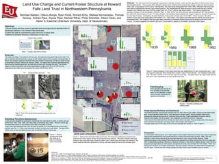
This study analyzed land use change and current forest structure at the Howard Falls Land Trust property in northwestern Pennsylvania using aerial photographs from 1939 to 1992 and tree core samples. The property experienced a shift from 43% cultivated land in 1939 to 63% forested land by 1992. Forest patches on the property ranged in age from at least 25 to over 75 years old based on the aerial photo analysis and tree core dating. Red maple dominated both the tree density and basal area in all seven forest plots sampled, though tree species richness across the plots was 10 species. The results indicate the property's forest development follows typical patterns observed in other former agricultural areas of the eastern deciduous forest region.