![In China, hundreds of millions of people leave the large
cities for their hometowns to celebrate the Chinese New Year
(CNY), and then return after the CNY holiday. The population
movements around the CNY, involving some 3 billion jour-
neys, represent the largest annual human migration event on
the planet. Several recent studies have detected significant
impacts of this mass human migration on the UHI effects
during the CNY holiday (Wu et al. 2015; Zhang et al. 2015;
Zhang and Wu 2015). However, how the effects of mass hu-
man migration on the UHI relate to meteorological conditions
remains a key unknown.
In this study, we investigate the dependence of Beijing’s
UHI on meteorological conditions and further explore the role
of meteorological conditions in assessing the impacts of mass
human migration on Beijing’s UHI during the CNY holiday.
We focus on the period 2004–2013 but exclude the Olympic
year of 2008 to avoid any possible effects of implemented
environmental control measures in this year.
2 Data and methods
The surface air temperature, precipitation, cloud cover, water
vapor, and wind speed data used in this study were obtained
from the China Meteorological Administration (http://data.
cma.cn/site/index.html). All the data were collected, quality
controlled, and processed by the National Meteorological
Information Center of the China Meteorological
Administration. The daily mean surface air temperature,
cloud cover, water vapor, and wind speed values were
produced by averaging measurements at 0200, 0800, 1400,
and 2000 LST.
The UHI intensity (ΔT) was calculated as daily mean sur-
face air temperature difference between urban (Turban) and
non-urban reference (Treference) stations.
ΔT ¼ Turban−Treference; ð1Þ
Urban areas of Beijing are mainly located on the southeast
plain of the city which occupies nearly 40% of the total area
and is surrounded by mountains on its northeast, north, and
west sides (Fig. 1). The urban station used in this study
[Beijing (39°48′N, 116°28′E)] is located in the southeastern
part of urban center, which is one of the most populous areas
of the city (Fig. 1). The non-urban reference station [Miyun
(40°23′N, 116°52′E)] is situated in the northeastern part of
Beijing, with a much lower population density (Yang 2015).
Miyun station has been used to represent non-urban or rural
areas in previous studies (Liu et al. 2007; Wang et al. 2013;
Zhang et al. 2015). The altitudes of Beijing and Miyun sta-
tions are 31.3 and 71.8 m, respectively. The Beijing and
Miyun stations both have no relocations in our study period
and are the only two national basic meteorological stations in
the plain areas of Beijing.
Since Beijing’s UHI effects and population movements
during the CNY holiday are both larger in recent years than
before, the study focuses on the period of 2004 to 2013, ex-
cluding 2008 to avoid any possible effects of environmental
control measures implemented in the Olympic year. The date
of the CNY is set according to the lunar calendar and falls
between 22 January and 18 February during the study period.
The CNY day is denoted as day(+1), the day before and after
as day(−1) and day(+2), and so on. The CNY week includes
7 days from CNY itself to 6 days after. In this paper, the CNY
week is referred to as week (+1), with 1 week before and after
being week(−1) and week(+2), and so on. The analysis covers
day(−21) to day(+28) or week(−3) to week(+4) for each study
year. In total, there are 441 days for the period of 2004–2013,
excluding the Olympic year of 2008. The background period
is defined as 2 to 3 weeks before and 2 to 3 weeks after the
CNY week [week(−3) to week(−2) and week(+3) to week(+
4)]. The dates of the CNY, the CNY week and the background
period are provided in Table 1. Precipitation and wind speed
data have no missing values for the analysis period. There are
the missing data for surface air temperature and water vapor
on the date of January 29, 2013 and cloud cover on the date of
February 23, 2011. We exclude the 2 days which are both
during the background period in all our analyses and use the
data for 439 days in total (Table 2).
3 Results
First, we examine differences in the ΔT between precipitating
days and non-precipitating days during the CNY holiday sea-
son (day(−21) to day(+28)), averaged over the study period
(i.e., 2004–2013, excluding the Olympic year of 2008). A
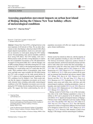
Fig. 1 Locations of Beijing and Miyun stations and the topography(m)
of Beijing. The three circles represent the second, fourth, and sixth Ring
Roads in Beijing. The red square denotes the urban center of Beijing
L. Wu, J. Zhang](data:image/gif;base64,R0lGODlhAQABAIAAAAAAAP///yH5BAEAAAAALAAAAAABAAEAAAIBRAA7)
Recommended
More Related Content
Similar to Population movement impact
Similar to Population movement impact (20)
Recently uploaded
Recently uploaded (20)
Population movement impact
- 1. ORIGINAL PAPER Assessing population movement impacts on urban heat island of Beijing during the Chinese New Year holiday: effects of meteorological conditions Lingyun Wu1 & Jingyong Zhang2,3 Received: 12 April 2016 /Accepted: 16 January 2017 # Springer-Verlag Wien 2017 Abstract Chinese New Year (CNY), or Spring Festival, is the most important of all festivals in China. We use daily obser- vations to show that Beijing’s urban heat island (UHI) effects largely depend on precipitation, cloud cover, and water vapor but are insensitive to wind speed, during the CNY holiday season. Non-precipitating, clear, and low humidity conditions favor strong UHI effects. The CNY holiday, with some 3 billion journeys made, provides a living laboratory to explore the role of population movements in the UHI phenomenon. Averaged over the period 2004–2013, with the Olympic year of 2008 excluded, Beijing’s UHI effects during the CNY week decline by 0.48 °C relative to the background period (4 weeks including 2 to 3 weeks before, and 2 to 3 weeks after, the CNY week). With combined effects of precipitation, large cloud cover, and high water vapor excluded, the UHI effects during the CNY week averaged over the study period decline by 0.76 °C relative to the background period, significant at the 99% confidence level by Student’s t test. These results indi- cate that the impacts of population movements can be more easily detected when excluding unfavorable meteorological conditions to the UHI. Population movements occur not only during the CNY holiday, but also during all the time across the globe. We suggest that better understanding the role of population movements will offer new insight into anthropo- genic climate modifications. 1 Introduction Human society has entered an urban era, with the majority of the world’s population dwelling in cities (UN DESA 2014). The built-up environment, impervious surfaces formed of man-made materials, and the heat released by human activities tend to make urban areas warmer than their surroundings—a phenomenon called the urban heat island (UHI) (Howard 1833; Oke 1982; Kalnay and Cai 2003; Grimm et al. 2008; Rosenzweig et al. 2009; Oleson et al. 2011; Georgescu et al. 2013; Myhre et al. 2013). UHIs occur in almost all city areas and can generate both beneficial and adverse impacts (Taha 1997; Bonan 2008; Ren et al. 2008; Weaver et al. 2009; Stewart and Oke 2012; Wu and Yang 2013; Zhao et al. 2014; Bounoua et al. 2015; Sachindra et al. 2015). The UHI intensity varies across and within cities, with time, and with meteorological conditions, including precipitation, cloud, air humidity, and wind (Arnfield 2003; Li et al. 2004; Zhou et al. 2004; Jin et al. 2005; Mahmood et al. 2014; Martin-Vide et al. 2015; Mirzaei 2015; Taha 2015). Beijing, located in North China, is one of the most popu- lous cities in the world. Beijing’s population is close to 22 million in 2015 and is projected to be 28 million by 2030 (UN DESA 2014). Spatial and temporal features of Beijing’s UHI have been widely addressed in previous studies (Zhang et al. 2002; Chu and Ren 2005; Ren et al. 2007; Miao et al. 2009; Yan et al. 2010; Yang et al. 2013). The UHI intensity expressed as surface air temperature difference has been found to be strongest in winter (Liu et al. 2007; Zhang et al. 2010; Yang et al. 2013). However, little attention is paid to how Beijing’s UHI changes with the meteorological conditions. * Jingyong Zhang zjy@mail.iap.ac.cn 1 State Key Laboratory of Numerical Modeling for Atmospheric Sciences and Geophysical Fluid Dynamics (LASG), Institute of Atmospheric Physics, Chinese Academy of Sciences, Beijing 100029, China 2 Center for Monsoon System Research, Institute of Atmospheric Physics, Chinese Academy of Sciences, Beijing 100029, China 3 University of Chinese Academy of Sciences, Beijing 100049, China Theor Appl Climatol DOI 10.1007/s00704-017-2043-7
- 2. In China, hundreds of millions of people leave the large cities for their hometowns to celebrate the Chinese New Year (CNY), and then return after the CNY holiday. The population movements around the CNY, involving some 3 billion jour- neys, represent the largest annual human migration event on the planet. Several recent studies have detected significant impacts of this mass human migration on the UHI effects during the CNY holiday (Wu et al. 2015; Zhang et al. 2015; Zhang and Wu 2015). However, how the effects of mass hu- man migration on the UHI relate to meteorological conditions remains a key unknown. In this study, we investigate the dependence of Beijing’s UHI on meteorological conditions and further explore the role of meteorological conditions in assessing the impacts of mass human migration on Beijing’s UHI during the CNY holiday. We focus on the period 2004–2013 but exclude the Olympic year of 2008 to avoid any possible effects of implemented environmental control measures in this year. 2 Data and methods The surface air temperature, precipitation, cloud cover, water vapor, and wind speed data used in this study were obtained from the China Meteorological Administration (http://data. cma.cn/site/index.html). All the data were collected, quality controlled, and processed by the National Meteorological Information Center of the China Meteorological Administration. The daily mean surface air temperature, cloud cover, water vapor, and wind speed values were produced by averaging measurements at 0200, 0800, 1400, and 2000 LST. The UHI intensity (ΔT) was calculated as daily mean sur- face air temperature difference between urban (Turban) and non-urban reference (Treference) stations. ΔT ¼ Turban−Treference; ð1Þ Urban areas of Beijing are mainly located on the southeast plain of the city which occupies nearly 40% of the total area and is surrounded by mountains on its northeast, north, and west sides (Fig. 1). The urban station used in this study [Beijing (39°48′N, 116°28′E)] is located in the southeastern part of urban center, which is one of the most populous areas of the city (Fig. 1). The non-urban reference station [Miyun (40°23′N, 116°52′E)] is situated in the northeastern part of Beijing, with a much lower population density (Yang 2015). Miyun station has been used to represent non-urban or rural areas in previous studies (Liu et al. 2007; Wang et al. 2013; Zhang et al. 2015). The altitudes of Beijing and Miyun sta- tions are 31.3 and 71.8 m, respectively. The Beijing and Miyun stations both have no relocations in our study period and are the only two national basic meteorological stations in the plain areas of Beijing. Since Beijing’s UHI effects and population movements during the CNY holiday are both larger in recent years than before, the study focuses on the period of 2004 to 2013, ex- cluding 2008 to avoid any possible effects of environmental control measures implemented in the Olympic year. The date of the CNY is set according to the lunar calendar and falls between 22 January and 18 February during the study period. The CNY day is denoted as day(+1), the day before and after as day(−1) and day(+2), and so on. The CNY week includes 7 days from CNY itself to 6 days after. In this paper, the CNY week is referred to as week (+1), with 1 week before and after being week(−1) and week(+2), and so on. The analysis covers day(−21) to day(+28) or week(−3) to week(+4) for each study year. In total, there are 441 days for the period of 2004–2013, excluding the Olympic year of 2008. The background period is defined as 2 to 3 weeks before and 2 to 3 weeks after the CNY week [week(−3) to week(−2) and week(+3) to week(+ 4)]. The dates of the CNY, the CNY week and the background period are provided in Table 1. Precipitation and wind speed data have no missing values for the analysis period. There are the missing data for surface air temperature and water vapor on the date of January 29, 2013 and cloud cover on the date of February 23, 2011. We exclude the 2 days which are both during the background period in all our analyses and use the data for 439 days in total (Table 2). 3 Results First, we examine differences in the ΔT between precipitating days and non-precipitating days during the CNY holiday sea- son (day(−21) to day(+28)), averaged over the study period (i.e., 2004–2013, excluding the Olympic year of 2008). A Fig. 1 Locations of Beijing and Miyun stations and the topography(m) of Beijing. The three circles represent the second, fourth, and sixth Ring Roads in Beijing. The red square denotes the urban center of Beijing L. Wu, J. Zhang
- 3. precipitating day is defined as the one with the daily precipi- tation amount at any one or both of urban and non-urban reference stations meeting or exceeding 0.1 mm. There are 48 precipitating days and 391 non-precipitation days for the whole study period (Table 2). The averaged ΔT is 1.07 °C on precipitating days, which is 1.42 °C and 57% smaller than on non-precipitating days in absolute and relative terms, respec- tively. These results indicate that precipitation plays an impor- tant role in influencing the UHI intensity during the CNY holiday season. We then analyze relationships of the ΔT to daily mean cloud cover, water vapor, and wind speed averaged at urban and non-urban reference stations during the CNY holiday sea- son over the study period (Figs. 2, 3 and 4). Generally speak- ing, the ΔT has close associations with cloud cover and water vapor: it near-linearly decreases with increasing cloud cover and water vapor (Figs. 2 and 3). For all years combined over the study period, correlations of the ΔT with cloud cover and water vapor are −0.55 and −0.46, respectively, both statistical- ly significant at the 99% confidence level. For each year of the study period, the associations of the ΔT with cloud cover and water vapor are also generally strong, with the correlation coefficients ranging from −0.27 to −0.73 and from −0.23 to −0.63, respectively. For all years combined, the correlation coefficients be- tween the ΔTand wind speed during the CNY holiday season are near zero (−0.03). For each year of the study period, the correlation coefficients are generally very small, ranging from −0.2 to 0.09 (Fig. 4). These results indicate that the association of the UHI intensity with the wind speed is quite weak during the CNY holiday season. The strong dependence of the ΔTon cloud cover and water vapor during the CNY holiday season also shows up in Fig. 5, which examines the ΔT bins according to different meteoro- logical conditions during the study period. Clearly, the ΔT decreased with increasing cloud cover and water vapor during the CNY holiday season. For 15% largest cloud cover (>85%) and 15% highest water vapor (>3.7 hPa), the ΔT values are 1.12 and 1.26 °C, respectively. They are both much smaller than the mean ΔTwhich is 2.34 °C. In contrast, the ΔTalmost has no dependence on wind speed. It should be noted that the higher altitude at the non-urban reference station than at the urban station may result in the overestimation of Beijing’s UHI intensity. Such an effect is expected to be limited regard- ing a difference of about 40 m (~0.26 °C assuming the tem- perature decreases with an increase of altitude at the lapse rate of 0.65 °C per 100 m, Memon et al. 2011) and might be offset by the effect of the urbanization development surrounding the non-urban reference station. The above results indicate that the ΔT strongly depends on the meteorological conditions including precipitation, cloud cover, and water vapor during the CNY holiday season. It is Table 1 Dates of the Chinese New Year (CNY), the CNY week, and the background period during 2004–2013, with the Olympic year of 2008 excluded Year CNY day CNY week Background period (before the CNY week) Background period (after the CNY week) 2004 22 January 22–28 January 1–14 January 5–18 February 2005 9 February 9–15 February 19 January to 1 February 23 February to 8 March 2006 29 January 29 January to 4 February 8–21 January 12–25 February 2007 18 February 18–24 February 28 January to 10 February 4–17 March 2009 26 January 26 January to1 February 5–18 January 9–22 February 2010 14 February 14–20 February 24 January to 6 February 28 February to 13 March 2011 3 February 3–9 February 13–26 January 17 February to 2 March 2012 23 January 23–29 January 2–15 January 6–19 February 2013 10 February 10–16 February 20 January to 2 February 24 February to 9 March Table 2 All days analyzed in the study, precipitating days, large cloud cover days (>85%), and high water vapor days (>3.7 hpa) during the whole study period, the CNY weeks, and the background period Period All days Precipitating days Large cloud cover days High water vapor days Study period 439 48 68 (15%) 68 (15%) CNY weeks 63 4 5 6 Background period 250 30 32 41 A precipitating day is defined as the one with the daily precipitation amount at any one or both of urban and non- urban reference stations meeting or exceeding 0.1 mm. Daily cloud cover and water vapor are averaged at urban and non-urban reference stations. The background period is defined as 4 weeks, including 2 weeks before [week(−3) to week(−2)] and after [week(+3) to week(+4)] the CNY week Population movements and UHI
- 4. estimated that nearly half of Beijing’s urban population returned their hometowns to celebrate the CNY in recent years. Finally, we examine the role of meteorological condi- tions in assessing the impacts of mass human migration on Beijing’s UHI during the CNY holiday. We compare the ΔT differences between the CNY week and the background period in five cases: all days; precipitating days excluded; large cloud cover (>85%) days excluded; high water vapor (>3.7 hPa) days excluded; and precipitating days, large cloud cover (>85%) days, and high water vapor Fig. 3 Scatter plots and linear regressions between the ΔT and daily mean water vapor averaged at urban and non-urban reference stations during the CNY holiday season [day(−21) to day(+28)] for the period 2004–2013, with the Olympic year of 2008 excluded. The CNY day is denoted as day(+ 1), while 1 day before and after the CNY day as day(−1) and day(+2), and so on Fig. 2 Scatter plots and linear regressions between the ΔT and daily mean cloud cover averaged at urban and non-urban reference stations during the CNY holiday season [day(−21) to day(+28)] for the period 2004–2013, with the Olympic year of 2008 excluded. The CNY day is denoted as day(+ 1), while 1 day before and after the CNY day as day(−1) and day(+2), and so on L. Wu, J. Zhang
- 5. (>3.7 hPa) days excluded (Fig. 6). A total of 4, 5, and 6 days during the CNY weeks and 30, 32, and 41 days during the background period are excluded for precipitation, large cloud cover, and high water vapor, respectively (Table 2). There are 11 days during the CNY weeks and 68 days during the back- ground period excluded for all unfavorable meteorological conditions including precipitation, large cloud cover, and high water vapor. Since two or three events happened concurrently on some days, the days excluded for all unfavorable meteorological conditions are less than the sum of the days excluded for precipitation, large cloud cover, and high water vapor. Under all meteorological conditions (all days case), the ΔT values in the CNY week and the background period are 2.07 and 2.55 °C, respectively. The ΔT decreases by 0.48 °C in the CNY week relative to the background period, signifi- cant at the 98% confidence level by Student’s t test. With precipitating days, large cloud cover days and high water va- por days excluded, the ΔT values decrease by 0.61, 0.60, and Fig. 4 Scatter plots and linear regressions between the ΔT and daily mean wind speed averaged at urban and non-urban reference stations during the CNY holiday season [day(−21) to day(+28)] for the period 2004–2013, with the Olympic year of 2008 excluded. The CNY day is denoted as day(+ 1), while 1 day before and after the CNY day as day(−1) and day(+2), and so on Fig. 5 The ΔT binned according to cloud cover, water vapor, and wind speed values during the CNY holiday season [day(−21) to day(+28)] for the period 2004–2013, with the Olympic year of 2008 excluded. The CNY day is denoted as day(+1), while 1 day before and after the CNY day as day(−1) and day(+2), and so on. The data are partitioned into 10 ranges (X-axis) with 0–1, 1–15, and so on for cloud cover (%), 0–1, 1–1.6 and so on for water vapor (hpa), and 0–1.5, 1.5–1.7, and so on for wind speed (m/s). No water vapor and wind speed values are larger than 10 hpa and 10 m/s, respectively Population movements and UHI
- 6. 0.65 °C in the CNY week relative to the background period, respectively. These changes are all significant at the 99% con- fidence level. They are 0.12 ~ 0.17 °C stronger than under all meteorological conditions. With all unfavorable meteorologi- cal conditions including precipitation, large cloud cover, and high water vapor excluded, the ΔT decreases by 0.76 °C in the CNY week relative to the background period, significant at the 99% confidence level. This reduction is 0.28 °C and 58% stronger than those under all meteorological conditions in rel- ative and absolute terms, respectively. 4 Conclusions and discussion CNYis the most important and ceremonious of all the Chinese festivals and holidays. The present study shows that Beijing’s UHI effects depend strongly on meteorological conditions in- cluding precipitation, cloud cover, and water vapor during the CNY holiday season. The UHI effects are much weaker on precipitating days than on non-precipitating days and near- linearly decrease with increasing cloud cover and water vapor. We further examine the role of mass human migration in the UHI phenomenon under different meteorological condi- tions. ΔT in the CNY week decreases by 0.48 °C relative to the background period under all meteorological conditions. When excluding precipitation days, large cloud cover days, and high water vapor days, the ΔT reductions in the CNY week are 0.61, 0.60, and 0.65 °C, respectively. These changes are all stronger than that under all meteorological conditions. The ΔT difference between the CNY week and the back- ground period is −0.76 °C when excluding all unfavorable meteorological conditions including precipitation, large cloud cover, and high water vapor, representing 0.28 °C and 58% reductions in absolute and relative terms compared with those under all meteorological conditions. Previous several studies provided observational evidence for the impacts of population movements on the UHI (Wu et al. 2015; Zhang et al. 2015; Zhang and Wu 2015). In this study, we take Beijing as an example to show that the role of population movements can be more easily detected when tak- ing meteorological conditions into consideration. Meanwhile, there are some limitations of this study that should be recognized. Since Beijing and many other regions in China have experienced rapid urbanization since the 1980s, it is very difficult to select corresponding rural stations in studies of UHI effects for China’s big cities. Miyun station used as the non-urban reference station also experienced some urbanization development in our study period though it is about 70 km away from the downtown Beijing, bringing some uncertainties to estimated UHI intensity. In addition, the alti- tude of Miyun station is about 40 m higher than that of Beijing station and may also bias our estimates. The biases caused by the urbanization development and the higher altitude of Miyun station may offset each other to some degree. A dense automatic weather station network has been devel- oped in Beijing and can provide hourly meteorological data. Yang et al. (2013) selected 8 non-urban reference stations from 185 automatic weather stations based on a strictly de- fined standard (Ren and Ren 2011), and further provided de- tailed spatial and temporal features of Beijing’s UHI for the period of 2007–2010. In future, to further our understanding of the role of meteorological conditions for Beijing’s UHI and its response to mass human migration during the CNY holi- day, observational data from dense automatic weather stations should be used, and more representative non-urban reference stations should be selected following the methods in Yang et al. (2013) and other studies. Our results indicate that taking the impacts of meteorolog- ical conditions into account helps to better identify the role of population movements in the urban climate during the CNY holiday. Some factors such as firework and firecrackers can Fig. 6 Mean UHI effects (ΔT) during the background period (left-hand bars) and the CNY week (right-hand bars), and the mean UHI difference (line), between the CNY week and the background period (ΔUHI: CNY week minus background period) averaged over the period 2004–2013, with the Olympic year of 2008 excluded. The CNY week is denoted as week(+1), while 1 week before and after the CNY week as week(−1) and week(+2), and so on. The background period is defined as 4 weeks, including 2 weeks before [week(−3) to week(−2)] and after [week(+3) to week(+4)] the CNY week L. Wu, J. Zhang
- 7. cause some uncertainties on our estimates of the population movement impacts on Beijing’s UHI during the CNY holiday that are subject to further investigation. Population move- ments occur anytime and worldwide, and their impacts on climate at a variety of temporal and spatial scales should be further addressed to advance our understanding of anthropo- genic climate modifications (Zhang and Wu 2016). Acknowledgements This work was supported by the National Natural Science Foundation of China (Grant Nos. 41675085,41275089 and 41305071). References Arnfield AJ (2003) Two decades of urban climate research: a review of turbulence, exchanges of energy and water, and the urban heat is- land. Int J Climatol 23:1–26 Bonan GB (2008) Ecological Climatology, 2nd edn 550 pp. Cambridge Univ Press, Cambridge, U.K. Bounoua L, Zhang P, Mostovoy G et al. (2015) Impact of urbanization on US surface climate. Environ Res Lett 10 doi:10.1088/1748-9326/ 10/8/084010 Chu Z, Ren G (2005) Effect of enhanced urban heat island magnitude on average surface air temperature series in Beijing region (in Chinese). Acta Meteorologica Sinica 63:534–540 Georgescu M, Moustaoui M, Mahalov A, Dudhia J (2013) Summer-time climate impacts of projected megapolitan expansion in Arizona. Nature Clim Change 3:37–41 Grimm NB, Faeth SH, Golubiewski NE, Redman CL, Wu J, Bai X, Briggs JM (2008) Global change and the ecology of cities. Science 319:756–760 Howard L (1833) The climate of London. Vol 1–3. Harvey and Dorton, London 1002pp Jin M, Dickinson RE, Zhang D (2005) The footprint of urban areas on global climate as characterized by MODIS. J Clim 18:1551–1565 Kalnay E, Cai M (2003) Impact of urbanization and land-use change on climate. Nature 423:528–531 Li Q, Zhang H, Liu X, Huang J (2004) Urban heat island effect on annual mean temperature during the last 50 years in China. Theor Appl Climatol 79:165–174 Liu W, Ji C, Zhong J, Jiang X, Zheng Z (2007) Temporal characteristics of the Beijing urban heat island. Theor Appl Climatol 87:213–221 Mahmood R, Pielke RA Sr, Hubbard KG et al (2014) Land cover changes and their biogeophysical effects on climate. Int J Climatol 34:929– 953 Martin-vide J, Sarricolea P, Moreno-Garcia MC (2015) On the definition of urban heat island intensity: the "rural" reference. Front Earth Sci 3. doi: 10.3389/feart.2015.00024 Memon R, Leung D, Liu C et al (2011) Urban heat island and its effect on the cooling and heating demands in urban and suburban areas of Hong Kong. Theor Appl Climatol 103:441–450 Miao S, Chen F, LeMone MA, Tewari M, Li Q, Wang Y (2009) An obser- vational and modeling study of characteristics of urban heat island and boundary layer structures in Beijing. J Appl Meteorol 48:484–501 Mirzaei PA (2015) Recent challenges in modeling of urban heat island. Sustainable and Society. doi:10.1016/j.scs.2015.04.001 Myhre GD, Shindell D, Bréon F-M et al (2013) Anthropogenic and nat- ural Radiative forcing. In: Stocker TF, Qin D, Plattner G-K, Tignor M, Allen SK, Boschung J, Nauels A, Xia Y, Bex V, Midgley PM (eds) Climate change 2013: the physical science basis. Contribution of working group I to the fifth assessment report of the intergovernmental panel on climate change. Cambridge University Press, Cambridge, United Kingdom and New York, NY, USA, pp 659–740. doi:10.1017/ CBO9781107415324.018 Oleson KW, Bonan GB, Feddema J, Jackson T (2011) An examination of urban heat island characteristics in a global climate model. Int J Climatol 31:1848–1865 Oke TR (1982) The energetic basis of the urban heat island. Quart J Roy Meteor Soc 108:1–24 Ren G, Chu Z, Chen Z, Ren Y (2007) Implications of temporal change in urban heat island intensity observed at Beijing and Wuhan stations. Geophys Res Lett 34:L05711. doi:10.1029/2006GL027927 Ren G, Zhou Y, Chu Z et al (2008) Urbanization effects on observed surface air temperature trends in North China. J Clim 21:1333–1348 Ren Y, Ren G (2011) A remote-sensing method of selecting reference stations for evaluating urbanization effect on surface air temperature trends. J Clim 24:3179–3189 Rosenzweig C, Solecki WD, Parshall L et al (2009) Mitigating New York City's heat island: integrating stakeholder perspectives and scientific evaluation. Bull Am Meteorol Soc 90:1297–1312 Sachindra DA, Ng AWM, Muthumaran S, Perera BJC (2015) Impact of climate change on urban heat island effect and extreme tempera- tures: a case study. Q J R Meteorol Soc 141: doi: 10.1002/qj.2642. Stewart ID, Oke TR (2012) Local climate zones for urban temperature studies. Bull Amer Meteor Soc 93:1879–1900 Taha H (1997) Urban climates and heat islands: albedo, evapotranspira- tion, and anthropogenic heat. Energy and Building 25:99–103 Taha H (2015) Meteorological, air-quality, and emission-equivalence im- pacts of urban heat island control in California. Sustainable Cities and Society. doi:10.1016/j.scs.2015.03.009 UN DESA Population Division (2014) World urbanization prospects: the 2014 revision. United Nations Department of Economic and Social Affairs (UN DESA) Population Division, New York, NY, USA Wang J, Yan Z, Li Z, Liu W, Wang Y (2013) Impact of urbanization on changes in temperature extremes in Beijing during 1978-2008. Chin Sci Bull 58:4679–4686 Weaver C, Cooter E, Gilliam R et al (2009) A preliminary synthesis of modeled climate change impacts on U. S. regional ozone concentra- tions. Bull Amer Meteor Soc 90:1843–1863 Wu K, Yang X (2013) Urbanization and heterogeneous surface warming in eastern China. Chi Sci Bull 58(12):1363–1373 Wu L, Zhang J, Shi C (2015) Mass human migration and the urban heat island during the Chinese New Year holiday: a case study in Harbin City, Northeast China. Atmos Oceanic Lett 8:63–66 Yan Z, Li Z, Li Q, Jones P (2010) Effects of site change and urbanisation in the Beijing temperature series 1977-2006. Int J Climatol 30: 1226–1234 Yang K (2015) Population distribution and multicenter measurement of great Beijing. China Population, Resources and Environment 25: 83–89 Yang P, Ren G, Liu W (2013) Spatial and temporal characteristics of Beijing urban heat island intensity. J Appl Meteorol 52:1803–1816 Zhao L, Lee X, Smith RB, Oleson K (2014) Strong contributions of local background climate to urban heat island. Nature 511:216–219 Zhang G, Xu X, Wang J, Yang Y (2002) A study of characteristics and evolution of urban heat island over Beijing and its surrounding area. J Appl Meteor Sci 13:43–50 (in Chinese) Zhang J, Zhang X, Wang X et al (2010) Time scale analysis of tempera- ture and its urban heat island effect in Beijing. Arid Land Geography 33:51–58 Zhang J, Wu L (2015) Modulation of the urban heat island by the tourism during the Chinese New Year holiday: a case study in Sanya City, Hainan Province of China. Chin Sci Bull 60. doi: 10.1007/s11434- 015-0864-2 Zhang, J, Wu L (2016) A New view of human impacts on the climate: the role of population movements. Sci Bull 61. doi: 10.1360/N972015- 01079. (in Chinese) Population movements and UHI
- 8. Zhang J, Wu L, Yuan F, Dou J, Miao S (2015) Mass human migration and Beijing's urban heat island during the Chinese New Year holiday. Sci Bull 60:1038–1041 Zhou L, Dickinson R, Tian Y, Fang J, Li Q, Kaufmann R, Tucker C, Myneni R (2004) Evidence for a significant urbanization effect on climate in China. Proc Natl Acad Sci U S A 101:9540–9544 L. Wu, J. Zhang