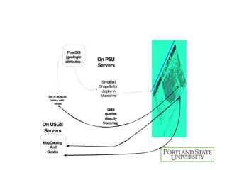
Web Mapping with Open Source GIS Software   Best practices from the PSU Experience David Percy Geospatial Data Manager, Geology Department Portland State University With gratitude to Morgan Harvey, Eric Hanson, Nate Davenport,  Cris Holm, Tim Welch, and Will Garrick Funding provided by many sources, including NASA, NSF, Oregon Dept of Geology, US  Geologic Survey OSCON 2007
Components of Open Source  Web Mapping The geospatial “LAMP” stack L – Linux A – Apache M – MySQL P – PHP L – Linux A – Apache M – MapServer P – PostGIS
Open Source Components GDAL – Raster Library OGR – Vector Library GD – Graphics Creation Proj.4 – Coordinate Systems FreeType – Nice fonts! GEOS – Geometry Engine Shapelib – Shapefile library
A closer look at the “stack” Front end –  PHP/Mapscript with Javascript PHP/Mapscript Pure CGI with template substitution Data in  PostGIS or Shapefiles for vector Geotiff, ECW or JPEG2000 for raster Referenced and styled by MAPFILE Mapserver CGI built with all the right “includes” Webserver – Apache Operating system - Linux
The Big Choice: What front end? Percy facilitates open source sessions  Ka-Map Chameleon MapBender, MapLab, FIST Grad Students revolt! Requirements defined Pan, Zoom, Query, some AJAX In a single weekend prototype developed Currently used in five production systems!
Special features: links from each glacier to “assets” database containing airphotos, oblique photos, and satellite data used for determinig temporal change during last century.
Special features: links from geologic map units to map catalog, lexicon of stratigraphic names, and more detailed data on state survey servers. Oh, and the GeoWiki!
Special features: uses Yahoo geocoder to zoom to  street address. Passed as coordinates, returned as XML to be parsed... Serves up over 10GB of imagery, with loads times ~7 seconds


Components of the National Geologic Map Database geographic search: Openlayers Javascript thick client Kamap Tiling engine to pre-render the five zoom levels Mapserver Cartographic styling and rendering of maps Prototype Javascript library Perl and Oracle  Database storage and retrieval
Querying, like a big submit button Capture image pixel clicked on, x, y Convert to coordinate system of data in PostGIS Query PostGIS with SQL select statement Return rows of any tables that intersect
Conclusions Open Source Web Mapping is reliable and proven Be careful what Open Source project you align with Many projects are brilliant, but orphaned ARC will continue support and development of Map-Fu, both for map interfaces and backend datastreams.
DEMOS http://Glaciers.us http://NGMDB. usgs . gov http://www.oregongeology.com/sub/ogdc/ http://www. oregongeology . com/sub/lidar/
Data Streams End of Monolithic Web Apps Open Geospatial Consortium (OGC)‏ WMS WFS Query for capabilities High Quality data streams from many sources, possibly aggregated through virtual globes, such as Google Earth, NASA WorldWind, etc

Os Percy

  • 1.
    Web Mapping withOpen Source GIS Software Best practices from the PSU Experience David Percy Geospatial Data Manager, Geology Department Portland State University With gratitude to Morgan Harvey, Eric Hanson, Nate Davenport, Cris Holm, Tim Welch, and Will Garrick Funding provided by many sources, including NASA, NSF, Oregon Dept of Geology, US Geologic Survey OSCON 2007
  • 2.
    Components of OpenSource Web Mapping The geospatial “LAMP” stack L – Linux A – Apache M – MySQL P – PHP L – Linux A – Apache M – MapServer P – PostGIS
  • 3.
    Open Source ComponentsGDAL – Raster Library OGR – Vector Library GD – Graphics Creation Proj.4 – Coordinate Systems FreeType – Nice fonts! GEOS – Geometry Engine Shapelib – Shapefile library
  • 4.
    A closer lookat the “stack” Front end – PHP/Mapscript with Javascript PHP/Mapscript Pure CGI with template substitution Data in PostGIS or Shapefiles for vector Geotiff, ECW or JPEG2000 for raster Referenced and styled by MAPFILE Mapserver CGI built with all the right “includes” Webserver – Apache Operating system - Linux
  • 5.
    The Big Choice:What front end? Percy facilitates open source sessions Ka-Map Chameleon MapBender, MapLab, FIST Grad Students revolt! Requirements defined Pan, Zoom, Query, some AJAX In a single weekend prototype developed Currently used in five production systems!
  • 6.
    Special features: linksfrom each glacier to “assets” database containing airphotos, oblique photos, and satellite data used for determinig temporal change during last century.
  • 7.
    Special features: linksfrom geologic map units to map catalog, lexicon of stratigraphic names, and more detailed data on state survey servers. Oh, and the GeoWiki!
  • 8.
    Special features: usesYahoo geocoder to zoom to street address. Passed as coordinates, returned as XML to be parsed... Serves up over 10GB of imagery, with loads times ~7 seconds
  • 9.
  • 10.
  • 11.
  • 12.
    Components of theNational Geologic Map Database geographic search: Openlayers Javascript thick client Kamap Tiling engine to pre-render the five zoom levels Mapserver Cartographic styling and rendering of maps Prototype Javascript library Perl and Oracle Database storage and retrieval
  • 13.
    Querying, like abig submit button Capture image pixel clicked on, x, y Convert to coordinate system of data in PostGIS Query PostGIS with SQL select statement Return rows of any tables that intersect
  • 14.
    Conclusions Open SourceWeb Mapping is reliable and proven Be careful what Open Source project you align with Many projects are brilliant, but orphaned ARC will continue support and development of Map-Fu, both for map interfaces and backend datastreams.
  • 15.
    DEMOS http://Glaciers.us http://NGMDB.usgs . gov http://www.oregongeology.com/sub/ogdc/ http://www. oregongeology . com/sub/lidar/
  • 16.
    Data Streams Endof Monolithic Web Apps Open Geospatial Consortium (OGC)‏ WMS WFS Query for capabilities High Quality data streams from many sources, possibly aggregated through virtual globes, such as Google Earth, NASA WorldWind, etc