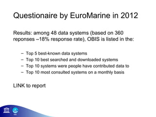
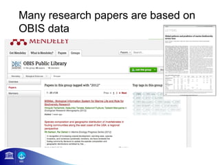
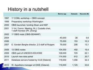
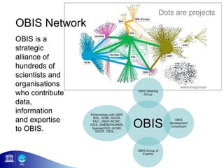
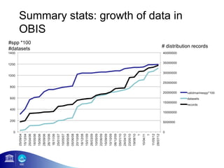
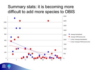
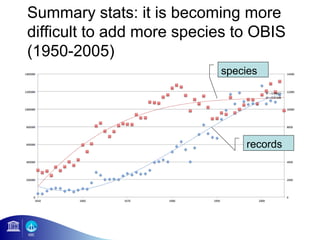
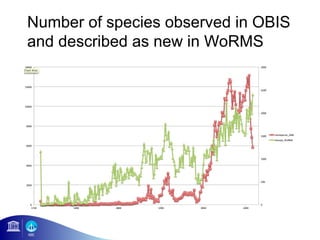
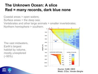
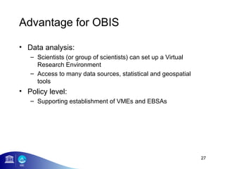
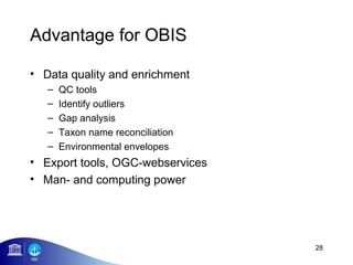
Introduction to
                                    OBIS


                Ward Appeltans
                  IOC/UNESCO

iMarine-VLIZ-OBIS Meeting, 28 Augustus 2012 - Oostende
VISION

We make biogeographic data from all over the world
freely available to policy makers, environmental
managers, researchers and the public at large, in order
to increase our knowledge to better manage and protect
our oceans.
History in a nutshell
                                                         Marine spp   Datasets   Records (M)

1997   1st COML workshop – OBIS concept
1999   Preparatory workshop Washington
2000   OBIS launched, funding Sloan and NSF
2001   1st Int. Comm. Meeting, M.J. Costello chair,
       1 staff member (Ph. Zhang)
2002   1st OBIS node (OBIS-SEAMAP)
2004                                                       40,000          38           5.6
2006                                                       75,000        153           10.3
2007   E. Vanden Berghe director, 2-3 staff at Rutgers     79,000        206           13.1

2008   13 OBIS nodes                                     104,000         492           16.4
2009   OBIS part of UNESCO-IOC/IODE                      108,000         725           22.1
2010   Launch new data portal                            114,000         912           30.7
2011   Database servers hosted by VLIZ (Ostend)          118,000       1,056           32.3

2012   W. Appeltans manager at IODE (Ostend)             119,000       1,125           33.6
Dots are projects
OBIS Network
OBIS is a
strategic
alliance of
hundreds of
scientists and
organisations
who contribute
data,
information
and expertise
to OBIS.
Questionaire by EuroMarine in 2012

Results: among 48 data systems (based on 360
reponses –18% response rate), OBIS is listed in the:

   –   Top 5 best-known data systems
   –   Top 10 best searched and downloaded systems
   –   Top 10 systems were people have contributed data to
   –   Top 10 most consulted systems on a monthly basis


LINK to report
Funding resources for the OBIS
Secretariat
• Current:
   – European Commission
        • iMarine EU FP7 project
   – UNESCO's Intergovernmental Oceanographic Commission
     (UNESCO-IOC)
        • IOC Member States: Flanders, Brazil, Canada, USA, Australia


• Past:
   –   Alfred P. Sloan Foundation
   –   Gordon and Betty Moore Foundation
   –   National Science Foundation (NSF)
   –   European Commisson (EMODNET)
   –   National Oceanographic Partnership Program (NOPP)
   –   National Oceanic and Atmospheric Administration (NOAA)
Data System Architecture

     portal                     Queries                     GBIF        GEO
                                Mapping
              production        Extraction                 EOL          iMarine

                                                                 LifeWatch
GCMD          staging
                                              WoRMS
marbound                                      ITIS, CoL, IRMNG

WOD/ODP
              assembly

GEBCO


       node             node   node
                                             -Excel, DiGIR, IPT
                                             -OBIS (extended DwC) schema
Association of observation points
  with oceanography
                                                       Observation data associated with
Environmental attributes from World Ocean Atlas            Bottom depth
                                                           Temperature
                                                           Salinity
                                                           Nitrogen / Oxygen
                                                           Phosphate / Silicate
                                                       Visualized through interactive graphs
                                                           Time-series graphs
                                                           Histograms


                      WOA09, http://www.nodc.noaa.gov/OC5/WOA09/pr_woa09.html
OBIS allows extraction of observations
   based on environmental conditions

                                                  Example map #1
                                                  Cetacean species observations in LME region
                                                  ‘Celtic-Biscay Shelf’
                                                  (no environmental conditions set)


Example map #2
Cetacean species observations in LME region
‘Celtic-Biscay Shelf’ filtered by a temperature
range of 13 to 15 degrees
Summary stats: very little historical
data
Summary stats: number of records
and species per year
Summary stats: growth of data in
    OBIS
#spp *100
#datasets                      # distribution records
Summary stats: it is becoming more
difficult to add more species to OBIS
Summary stats: it is becoming more
difficult to add more species to OBIS
(1950-2005)
                           species


                               records
Number of species observed in OBIS
and described as new in WoRMS
The Unknown Ocean: A slice
 Red = many records, dark blue none
Coastal areas > open waters;
Surface areas > the deep sea;
Vertebrates and other large animals > smaller invertebrates;
Northern hemisphere > southern.


The vast midwaters,
Earth’s largest
habitat by volume,
mostly unexplored
(~95%)


                                            Source: CoML OBIS
                                            Webb, O’Dor, Vanden Berghe
OBIS assists in identifying global patterns
in the distribution of biodiversity


(a) Total records in OBIS, corrected for the difference in surface area
between squares on different latitude; (b) total number of species, corrected
for surface area; (c) Shannon Index; (d) Hurlbert’s index, es(50)
An altered ocean: changes in composition and
abundance (90% declines in some groups)


                                         1950s


                                         1980s


                                         2007


                               McClenachen (2009) Cons. Biol.
CBD-COP10 listed OBIS as a key source of
 information for the identification of Ecologically or
 Biologically Significant Areas (EBSAs) part of CBD


                                                Areas of special importance
                                                   for the life history of a
 Areas of significant naturalness
       Areas of high biodiversity


                                                          species
                  Areas of
             uniqueness or rarity
OBIS feeds models of species
distributions and species richness


       ‘Aquamaps’ uses environmental envelope
       modelling to extrapolate species distributions
       beyond the actual observations
       (www.aquamaps.org)
Many research papers are based on
OBIS data
Social media
IMarine
• iMarine is a new EU project to establish a global e-
  infrastructure to share data & knowledge for
  sustainable fisheries management and conservation
  policies. In iMarine, IOC/OBIS coordinates the
  biodiversity cluster and is involved in the creation of a
  Community of Practice.

http://www.i-marine.eu


                                                         23
OBIS’ role in iMarine
Efforts:
•WP3 (18 person months)
    – setting up an Ecosystem Approach Community of Practice (EA-
       CoP) through:
         • iMarine Board meetings, data and metadata harmonisation and
           standardisation
         • Business Cases/Clusters (e.g. Biodiversity)
•WP6 (6 person months)
    – Virtual Research Environments Deployment and Operation
Set Operations – Algebraic Operations


Occurrence Data from GBIF                       Occurrence Data from WoRMS


                        Occurrence Data from OBIS

           ∩                      ᴜ                        -
       Intersection             Union                 Difference

                 A Data Set centric view will be adopted
Advantage for OBIS

• Data analysis:
   – Scientists (or group of scientists) can set up a Virtual
     Research Environment
   – Access to many data sources, statistical and geospatial
     tools
• Policy level:
   – Supporting establishment of VMEs and EBSAs


                                                                27
Advantage for OBIS

• Data quality and enrichment
   –   QC tools
   –   Identify outliers
   –   Gap analysis
   –   Taxon name reconciliation
   –   Environmental envelopes
• Export tools, OGC-webservices
• Man- and computing power


                                   28

OBIS introduction-for-i marine

  • 1.
    Introduction to OBIS Ward Appeltans IOC/UNESCO iMarine-VLIZ-OBIS Meeting, 28 Augustus 2012 - Oostende
  • 2.
    VISION We make biogeographicdata from all over the world freely available to policy makers, environmental managers, researchers and the public at large, in order to increase our knowledge to better manage and protect our oceans.
  • 3.
    History in anutshell Marine spp Datasets Records (M) 1997 1st COML workshop – OBIS concept 1999 Preparatory workshop Washington 2000 OBIS launched, funding Sloan and NSF 2001 1st Int. Comm. Meeting, M.J. Costello chair, 1 staff member (Ph. Zhang) 2002 1st OBIS node (OBIS-SEAMAP) 2004 40,000 38 5.6 2006 75,000 153 10.3 2007 E. Vanden Berghe director, 2-3 staff at Rutgers 79,000 206 13.1 2008 13 OBIS nodes 104,000 492 16.4 2009 OBIS part of UNESCO-IOC/IODE 108,000 725 22.1 2010 Launch new data portal 114,000 912 30.7 2011 Database servers hosted by VLIZ (Ostend) 118,000 1,056 32.3 2012 W. Appeltans manager at IODE (Ostend) 119,000 1,125 33.6
  • 4.
    Dots are projects OBISNetwork OBIS is a strategic alliance of hundreds of scientists and organisations who contribute data, information and expertise to OBIS.
  • 5.
    Questionaire by EuroMarinein 2012 Results: among 48 data systems (based on 360 reponses –18% response rate), OBIS is listed in the: – Top 5 best-known data systems – Top 10 best searched and downloaded systems – Top 10 systems were people have contributed data to – Top 10 most consulted systems on a monthly basis LINK to report
  • 6.
    Funding resources forthe OBIS Secretariat • Current: – European Commission • iMarine EU FP7 project – UNESCO's Intergovernmental Oceanographic Commission (UNESCO-IOC) • IOC Member States: Flanders, Brazil, Canada, USA, Australia • Past: – Alfred P. Sloan Foundation – Gordon and Betty Moore Foundation – National Science Foundation (NSF) – European Commisson (EMODNET) – National Oceanographic Partnership Program (NOPP) – National Oceanic and Atmospheric Administration (NOAA)
  • 7.
    Data System Architecture portal Queries GBIF GEO Mapping production Extraction EOL iMarine LifeWatch GCMD staging WoRMS marbound ITIS, CoL, IRMNG WOD/ODP assembly GEBCO node node node -Excel, DiGIR, IPT -OBIS (extended DwC) schema
  • 8.
    Association of observationpoints with oceanography Observation data associated with Environmental attributes from World Ocean Atlas  Bottom depth  Temperature  Salinity  Nitrogen / Oxygen  Phosphate / Silicate Visualized through interactive graphs  Time-series graphs  Histograms WOA09, http://www.nodc.noaa.gov/OC5/WOA09/pr_woa09.html
  • 9.
    OBIS allows extractionof observations based on environmental conditions Example map #1 Cetacean species observations in LME region ‘Celtic-Biscay Shelf’ (no environmental conditions set) Example map #2 Cetacean species observations in LME region ‘Celtic-Biscay Shelf’ filtered by a temperature range of 13 to 15 degrees
  • 10.
    Summary stats: verylittle historical data
  • 11.
    Summary stats: numberof records and species per year
  • 12.
    Summary stats: growthof data in OBIS #spp *100 #datasets # distribution records
  • 13.
    Summary stats: itis becoming more difficult to add more species to OBIS
  • 14.
    Summary stats: itis becoming more difficult to add more species to OBIS (1950-2005) species records
  • 15.
    Number of speciesobserved in OBIS and described as new in WoRMS
  • 16.
    The Unknown Ocean:A slice Red = many records, dark blue none Coastal areas > open waters; Surface areas > the deep sea; Vertebrates and other large animals > smaller invertebrates; Northern hemisphere > southern. The vast midwaters, Earth’s largest habitat by volume, mostly unexplored (~95%) Source: CoML OBIS Webb, O’Dor, Vanden Berghe
  • 17.
    OBIS assists inidentifying global patterns in the distribution of biodiversity (a) Total records in OBIS, corrected for the difference in surface area between squares on different latitude; (b) total number of species, corrected for surface area; (c) Shannon Index; (d) Hurlbert’s index, es(50)
  • 18.
    An altered ocean:changes in composition and abundance (90% declines in some groups) 1950s 1980s 2007 McClenachen (2009) Cons. Biol.
  • 19.
    CBD-COP10 listed OBISas a key source of information for the identification of Ecologically or Biologically Significant Areas (EBSAs) part of CBD Areas of special importance for the life history of a Areas of significant naturalness Areas of high biodiversity species Areas of uniqueness or rarity
  • 20.
    OBIS feeds modelsof species distributions and species richness ‘Aquamaps’ uses environmental envelope modelling to extrapolate species distributions beyond the actual observations (www.aquamaps.org)
  • 21.
    Many research papersare based on OBIS data
  • 22.
  • 23.
    IMarine • iMarine isa new EU project to establish a global e- infrastructure to share data & knowledge for sustainable fisheries management and conservation policies. In iMarine, IOC/OBIS coordinates the biodiversity cluster and is involved in the creation of a Community of Practice. http://www.i-marine.eu 23
  • 24.
    OBIS’ role iniMarine Efforts: •WP3 (18 person months) – setting up an Ecosystem Approach Community of Practice (EA- CoP) through: • iMarine Board meetings, data and metadata harmonisation and standardisation • Business Cases/Clusters (e.g. Biodiversity) •WP6 (6 person months) – Virtual Research Environments Deployment and Operation
  • 26.
    Set Operations –Algebraic Operations Occurrence Data from GBIF Occurrence Data from WoRMS Occurrence Data from OBIS ∩ ᴜ - Intersection Union Difference A Data Set centric view will be adopted
  • 27.
    Advantage for OBIS •Data analysis: – Scientists (or group of scientists) can set up a Virtual Research Environment – Access to many data sources, statistical and geospatial tools • Policy level: – Supporting establishment of VMEs and EBSAs 27
  • 28.
    Advantage for OBIS •Data quality and enrichment – QC tools – Identify outliers – Gap analysis – Taxon name reconciliation – Environmental envelopes • Export tools, OGC-webservices • Man- and computing power 28

Editor's Notes

  • #17 OBIS exposes the still-to-be-explored ocean by depth as well as latitude and longitude. On a cross section of the global oceans, the spectrum from red to blue extends from many to few or no records. The records are concentrated near shores and in shallow waters, while the largest habitat on Earth, the vast middle waters, is largely unexplored. For more than 20 percent of the ocean ’ s volume the Census database still has no records at all, and for vast areas very few. Source: Ocean Biogeographic Information System
  • #19 For larger fishes and other vertebrates, historical records indicate a decline of about 90% of top predators in comparison to past levels. Recovery, though typically very slow, may be possible when protective measures are taken. Despite such alarming declines, the ocean still holds plenty of marine life which requires appropriate management and conservation measures.
  • #27 Generally speaking if we consider the occurrence points as pure collections, then the classic algebraic operation can be applied. Our idea is to apply a Data Set centric paradigm: a user could be investigating a certain dataset coming from a single source. Then, at a certain moment, he\\she could want to expand such set. Then the user will search for other datasets on the same species and will possible merge the information. For such scope, algebraic operations can allow to highlight some points respect to others by understanding which are common observations (those in the union set) and which are uncommon (those in the subtraction set).