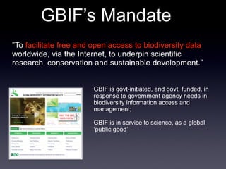
Download to read offline
![[results]: webportal
taxonomy, biogeography
vizualisation
open access
725,000 visitors
5,075,000 hits
32,000,000 dld records
V2alpha coming up](https://image.slidesharecdn.com/danisraymond-100608154717-phpapp01/85/Danis-raymond-14-320.jpg)
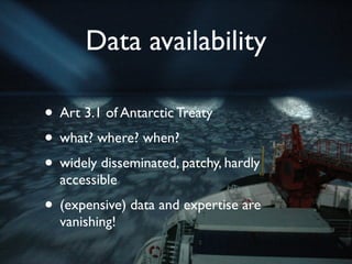
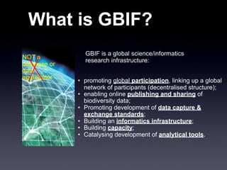
![[results]: RAMS
• The first RAMS
• Board of 60+ editors
all taxa
all species
• Feeds WoRMS, CoL and
EoL
valid species
• 16,475 taxa
0 3,750 7,500 11,250 15,000
• 9,346 species](https://image.slidesharecdn.com/danisraymond-100608154717-phpapp01/85/Danis-raymond-15-320.jpg)
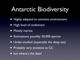
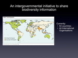
![[results]: ANTOBIS
1,088,044 records
172 datasets
106 geodatasets
5,235 taxa
Feeds OBIS, GBIF
Downloadable
WebGIS
Webservices](https://image.slidesharecdn.com/danisraymond-100608154717-phpapp01/85/Danis-raymond-16-320.jpg)
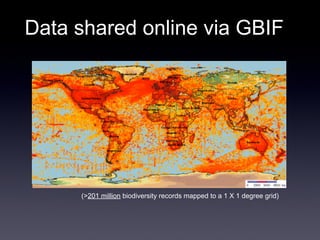
![[apps]: conservation
World Summit on Sustainable Development, 2001: “establish
comprehensive, effectively managed, and ecologically representative
networks of marine protected areas by 2012”
By 2010, collate relevant data for as many of the 11 priority regions
as possible (and other regions as appropriate), and characterise each
region in terms of biodiversity patterns and ecosystem processes,
physical environmental features and human activities.
By end 2011, submit proposals for candidate areas for protection to
the CCAMLR Scientific Committee.
By 2012, submit proposals on a representative system of Southern
Ocean MPAs to the CCAMLR Commission.](https://image.slidesharecdn.com/danisraymond-100608154717-phpapp01/85/Danis-raymond-17-320.jpg)
![[apps]: modeling
Bivalve richness
10 environmental variables](https://image.slidesharecdn.com/danisraymond-100608154717-phpapp01/85/Danis-raymond-18-320.jpg)
![[apps]: response to change
Cope or adapt
Move (deeper, south)
Go extinct
1976 - 2003
Over 2-fold decrease / 10 years
Over 2-fold increase / 10 years
Atkinson et al 2004](https://image.slidesharecdn.com/danisraymond-100608154717-phpapp01/85/Danis-raymond-19-320.jpg)
![[apps]: where should we look?
Southern Limits Northern Limits
Over 2-fold decrease / 10 years
Over 2-fold increase / 10 years
Barnes Atkinson et al 2004
et al., 2009](https://image.slidesharecdn.com/danisraymond-100608154717-phpapp01/85/Danis-raymond-20-320.jpg)
![[apps]: expedition design
Limopsis prediction
model fits actual data
map shows where to go](https://image.slidesharecdn.com/danisraymond-100608154717-phpapp01/85/Danis-raymond-21-320.jpg)
![[apps]: expedition design
Limopsis prediction
model fits actual data
map shows where to go](https://image.slidesharecdn.com/danisraymond-100608154717-phpapp01/85/Danis-raymond-22-320.jpg)
![!
!"#$%&'(&#&)*+'
!
[apps]: data exploration
Strugnell J. British Antarctic Survey
!
!
!"#$%&',"! #$%!&'&()!*+,-%./!'0!())!,(.1*%!/(,2)%!/1&%/!(*3!/2%41%/!0'+*3!51&$1*!%(4$!
4%))!'0!(!67!'0!)(&1&+3%!-8!67!'0!)'*91&+3%!9.13:!0.',!31/&.1-+&1'*!.%4'.3/!1*!;<=>?@(.ABC"!!
#$%!.%3!)1*%!1*314(&%/!&$%!,%(*!2'/1&1'*!'0!&$%!=*&(.4&14!D')(.!E.'*&:!5$14$!3%01*%/!&$%!
,(F1,+,!*'.&$%.*!%F&%*&!'0!&$1/!/&+38"!!="!!;(,2)%!/1&%/"!!A"!!;2%41%/!.14$*%//!G&'&()!*+,-%.!
'0!())!,(.1*%!/2%41%/!.%4'.3%3!1*!&$(&!4%))H"!
!
"#$%&'!(!" #$%&'%()*"+,-.$,/'.,0("01"+%2.3"456"01"/%(.3,)"-7528,(9",(".3%":0'.3%$("](https://image.slidesharecdn.com/danisraymond-100608154717-phpapp01/85/Danis-raymond-23-320.jpg)
![[apps]: gaps analysis
• taxonomy: some groups
under-represented
• spatial: deep-sea, Amundsen
sea,...
• time: paleontology
• huge datasets are missing](https://image.slidesharecdn.com/danisraymond-100608154717-phpapp01/85/Danis-raymond-24-320.jpg)
![[projects] some examples
ANTABIF (www.biodiversity.aq)
SCAR-MarBIN V2 alpha
Antarctic Field Guides
Georeferenced genetic data
Polar Macroscope Synthesis
Antarctic Biodiversity Atlas](https://image.slidesharecdn.com/danisraymond-100608154717-phpapp01/85/Danis-raymond-25-320.jpg)
![[main] Challenges
Quickly evolving needs from the community
Gaps in the data: taxonomy (microbes, kinetics??),
spatial, temporal, institutional, IPY data
Fear to publish (but happy to use)
The community needs to value the publication of data
Funding: hard to make a DB look sexy...](https://image.slidesharecdn.com/danisraymond-100608154717-phpapp01/85/Danis-raymond-26-320.jpg)
![[vision] The future
• Polar Information Commons (PIC): framework for
long-term stewardship of polar data
• ongoing applications: fill the gaps, strategic
conservation planning, optimized expedition
design,...
• flying across disciplines...?](https://image.slidesharecdn.com/danisraymond-100608154717-phpapp01/85/Danis-raymond-27-320.jpg)

The document discusses biodiversity data from Antarctica and efforts to make it freely accessible online. It describes several initiatives including SCAR-MarBIN, ANTABIF, and GBIF that host Antarctic biodiversity data and enable users to access over 1 million records. Examples of applications for the data are also provided, such as modeling species distributions, examining responses to climate change, and designing targeted scientific expeditions. Challenges in fully realizing the potential of the data are also discussed.


![Getting Started with Apache Spark: Big Data Made Simple [Free Meetup]](https://cdn.slidesharecdn.com/ss_thumbnails/apachesparkgettingstarted-260203175547-8361bcc3-thumbnail.jpg?width=640&height=640&fit=bounds)