Oaks Gateway Traffic Calming
•Download as PPT, PDF•
0 likes•297 views
Steetscape & Community Enhancements to protect the Village of Oaks. Mitigating the effects of roadway widening and increased traffic.
Report
Share
Report
Share

Recommended
Lde 362 gammage final torchia
The document proposes updates to the Gammage Landscape to improve pedestrian access and circulation. It analyzes existing issues like lack of shade and inefficient parking layout. The proposed plan aims to solve circulation problems through realigned roads and walkways, add more gathering spaces and planting areas, and maximize pedestrian priority and comfort while preserving key historic elements. The updates are intended to make the space more functional and appealing for visitors without disrespecting the historic aspects of the site.
Achieving Separated Cycling Facilities in a Constrained Town Centre Environme...
The Woden Town Centre is entering a new phase of development. To support and encourage active travel modes through the precinct, preliminary sketch plan designs were prepared for cycling facilities on the key roads (Corinna Street, Furzer Street and Matilda Street) through the Town Centre. The designs sought to maximise safety through separated facilities and coordinated treatments that directly benefit pedestrians and cyclists – facilitating ease of movement and encouraging increased walking and cycling.
City of Gary Comprehensive Plan Exhibit_Maps_Land Use Designation
The document provides descriptions of different land use types in Gary, Indiana's comprehensive plan. It outlines residential, commercial, employment, and open space/public land uses. Residential ranges from stable neighborhoods to distressed areas transitioning to other uses. Commercial includes downtown, mixed-use corridors, and transit-oriented development. Employment comprises light industrial, heavy industrial, and airport/intermodal uses. Open space includes conserved lands, parks, and vacant land being reused.
Rezoning for 1405 University Dr.
This document discusses a proposed rezoning and Planned Development District (PDD) for 1405 University Drive. Key aspects of the proposed PDD include doubling the density and reducing setbacks compared to existing zoning, with modifications to use P-MUD uses, parking reductions, and transportation changes like reduced driveway spacing and block length. Community benefits proposed include redeveloping the primary arrival gateway, demolishing existing buildings, and implementing multi-modal facilities and intersection improvements.
WorkSamples
The document lists the educational and professional experience of Andreia Chan Gao. It includes schools she attended in Portugal as well as professional experience working on architectural projects including a school renovation, city museum, and international design competition. It also includes recommendations from previous employers praising her work ethic, skills, and ability to work well in a team environment.
Emmp community presentations_anc oct 15 presentation final rev1
The document summarizes an ANC meeting about plans for updating Eastern Market Park in Washington, D.C. It discusses the project goals of creating a modern town square that improves safety, accessibility, and sustainability. Community input helped inform key design elements like the playground location and traffic calming measures. Renderings show plans for a pavilion, paths, plantings, and other features. A transportation study evaluated parking and traffic impacts, finding most intersections would operate acceptably with proposed changes like closing D Street. Maintenance responsibilities between agencies and a draft budget were also outlined.
Emmp community meeting#5 12-12-2019_presentation
The document provides an overview and updates on the Metro Park Eastern Market project. Key points include:
- The project is driven by a 2015 community-led master plan to update the park to modern standards.
- Construction is planned to start in spring 2020 and be completed in phases over 2020-2021.
- The project will include new playgrounds, a splash pad, seating areas, and improvements to pedestrian access and safety.
- Maintenance of the new park will be led by DGS, including landscaping, irrigation, playground inspections, and capital upgrades.
Task 3.b: EN TRIPS Priority Corridors - Preliminary Street Redesign Alternat...
Task 3.b: EN TRIPS Priority Corridors - Preliminary Street Redesign Alternat...Eastern Neighborhoods Transportation Implementation Planning Study
This memorandum provides descriptions and analysis of concept alternatives developed for transportation projects on Folsom and Howard Streets and Seventh and Eighth Streets in San Francisco's South of Market neighborhood. Ten alternatives were initially considered. For Folsom and Howard, alternatives 1, 6, and 9 were recommended for further consideration. Alternative 1 would convert the streets to a two-lane, one-way configuration with cycletracks. Alternative 6 would implement a hybrid one-way/two-way configuration. Alternative 9 would convert the streets to a two-lane, two-way configuration with buffered bike lanes. The alternatives aim to improve safety and comfort for pedestrians and cyclists while maintaining adequate vehicle capacity and access for businesses.Recommended
Lde 362 gammage final torchia
The document proposes updates to the Gammage Landscape to improve pedestrian access and circulation. It analyzes existing issues like lack of shade and inefficient parking layout. The proposed plan aims to solve circulation problems through realigned roads and walkways, add more gathering spaces and planting areas, and maximize pedestrian priority and comfort while preserving key historic elements. The updates are intended to make the space more functional and appealing for visitors without disrespecting the historic aspects of the site.
Achieving Separated Cycling Facilities in a Constrained Town Centre Environme...
The Woden Town Centre is entering a new phase of development. To support and encourage active travel modes through the precinct, preliminary sketch plan designs were prepared for cycling facilities on the key roads (Corinna Street, Furzer Street and Matilda Street) through the Town Centre. The designs sought to maximise safety through separated facilities and coordinated treatments that directly benefit pedestrians and cyclists – facilitating ease of movement and encouraging increased walking and cycling.
City of Gary Comprehensive Plan Exhibit_Maps_Land Use Designation
The document provides descriptions of different land use types in Gary, Indiana's comprehensive plan. It outlines residential, commercial, employment, and open space/public land uses. Residential ranges from stable neighborhoods to distressed areas transitioning to other uses. Commercial includes downtown, mixed-use corridors, and transit-oriented development. Employment comprises light industrial, heavy industrial, and airport/intermodal uses. Open space includes conserved lands, parks, and vacant land being reused.
Rezoning for 1405 University Dr.
This document discusses a proposed rezoning and Planned Development District (PDD) for 1405 University Drive. Key aspects of the proposed PDD include doubling the density and reducing setbacks compared to existing zoning, with modifications to use P-MUD uses, parking reductions, and transportation changes like reduced driveway spacing and block length. Community benefits proposed include redeveloping the primary arrival gateway, demolishing existing buildings, and implementing multi-modal facilities and intersection improvements.
WorkSamples
The document lists the educational and professional experience of Andreia Chan Gao. It includes schools she attended in Portugal as well as professional experience working on architectural projects including a school renovation, city museum, and international design competition. It also includes recommendations from previous employers praising her work ethic, skills, and ability to work well in a team environment.
Emmp community presentations_anc oct 15 presentation final rev1
The document summarizes an ANC meeting about plans for updating Eastern Market Park in Washington, D.C. It discusses the project goals of creating a modern town square that improves safety, accessibility, and sustainability. Community input helped inform key design elements like the playground location and traffic calming measures. Renderings show plans for a pavilion, paths, plantings, and other features. A transportation study evaluated parking and traffic impacts, finding most intersections would operate acceptably with proposed changes like closing D Street. Maintenance responsibilities between agencies and a draft budget were also outlined.
Emmp community meeting#5 12-12-2019_presentation
The document provides an overview and updates on the Metro Park Eastern Market project. Key points include:
- The project is driven by a 2015 community-led master plan to update the park to modern standards.
- Construction is planned to start in spring 2020 and be completed in phases over 2020-2021.
- The project will include new playgrounds, a splash pad, seating areas, and improvements to pedestrian access and safety.
- Maintenance of the new park will be led by DGS, including landscaping, irrigation, playground inspections, and capital upgrades.
Task 3.b: EN TRIPS Priority Corridors - Preliminary Street Redesign Alternat...
Task 3.b: EN TRIPS Priority Corridors - Preliminary Street Redesign Alternat...Eastern Neighborhoods Transportation Implementation Planning Study
This memorandum provides descriptions and analysis of concept alternatives developed for transportation projects on Folsom and Howard Streets and Seventh and Eighth Streets in San Francisco's South of Market neighborhood. Ten alternatives were initially considered. For Folsom and Howard, alternatives 1, 6, and 9 were recommended for further consideration. Alternative 1 would convert the streets to a two-lane, one-way configuration with cycletracks. Alternative 6 would implement a hybrid one-way/two-way configuration. Alternative 9 would convert the streets to a two-lane, two-way configuration with buffered bike lanes. The alternatives aim to improve safety and comfort for pedestrians and cyclists while maintaining adequate vehicle capacity and access for businesses.Hearst community meeting 04.05.2018
The meeting will focus on Phase I improvements to Hearst Park funded for 2018, including a new playground, walking trails, landscaping, and drainage. Phase II plans for 2019 include renovating the pool and tennis courts while keeping construction south of the existing tennis fence. Next steps include updating the ANC, posting the presentation online, procuring a general contractor for Phase I, and a future community meeting on updated designs.
Eastern market community meeting presentation 012202020
The document provides updates on the Eastern Market Metro Park project including:
- Construction is scheduled to occur in two phases from early 2020 to late 2020, with phase one focusing on Parcel 1.
- The document reviews partnership and programming opportunities for the park, including examples of how individuals and organizations can become Friends of Parks or Adopt-a-Park partners.
- Plans for the park pavilion, wayfinding signage, and phase one construction logistics covering noise, dust control, and contractor parking are presented for discussion at the project meeting.
DTN/EL Park District Presentation to City Council on 12/10/13
1) The East Lansing Park District project team presented the process and preferred alternative master plan to the East Lansing City Council.
2) Over multiple public workshops and charrettes, the team gathered feedback on priorities and design concepts from the community.
3) The preferred alternative includes 490 apartments, 900 parking spaces, 50,000 square feet of retail, and a 120 room hotel organized around a central public space with connections to the existing park.
2015 03 25 Powerpoint Presentation
This document provides an overview and agenda for a public meeting on the Downtown Redding Transportation Plan. The meeting covered objectives to improve regional trail connections, create a more walkable downtown, and explore reopening streets through the promenade area. Attendees provided input through keypad polling on issues like preferred parking and bike routes. Strategies were presented to achieve the objectives, including improving wayfinding, developing a parking strategy, and adding amenities to promote activity in the promenade area. The next steps are to get public feedback on concept alternatives before selecting a preferred plan.
XXL2013 - Team 3 - PinUp Presentation
Xi Guo - Architectural Designer
Feng Liu - Structural Designer
Morris Yang - Envelope Designer
Rafail Gkaidatzis - Comp. Designer
Ioannis Gkikas - Climate Designer
Route 20 Shared Use Path - Albemarle/Charlottesville
The planned Route 20 shared use path that will better connect Charlottesville to the Piedmont Virginia Communiity College campus, Saunders-Monticello Trail and beyond. This presentation was given by Jessica Hersh-Ballering from the Thomas Jefferson Planning District Commission on a virtual meetup hosted by Peter Krebs from The Piedmont Environmental Council. April 2, 2020.
Downtown Redding Transportation Plan Workshop 2 combined boards
The document presents an action plan for improving the promenade area in downtown Redding through streetscape design. It includes illustrations and descriptions of design considerations and elements for different street types including the promenade, alleys, paseos, mixed use streets, commercial thoroughfares. Elements discussed include improving pedestrian safety, traffic calming, increasing pedestrian spaces, and integrating stormwater management through landscapes strategies like bio-retention and permeable paving. The goal is to create a vibrant downtown that balances different transportation modes and land uses.
Rezoning of Property at 410 Texas Ave. (former site of Plaza Hotel)
This document discusses agenda item #1 for rezoning 410 Texas Avenue from PDD to allow for higher density development with modifications to zoning district standards, uses, parking, and transportation requirements. It lists the requested modifications and community benefits including redevelopment, demolition of existing buildings, use of design standards from other projects, and intersection improvements. The planning commission recommends approval because the project provides a connected multimodal transportation network, transit opportunities, and intersection improvements to offset development impacts.
2015 09 24 ppt presentation
The document summarizes a workshop for a transportation plan for downtown Redding. It includes an introduction and agenda, with presentations on the project team, study area, objectives, work to date including outreach, and a vision statement. It then outlines action plans for vehicular transportation, the promenade area, pedestrian access, bicycling, transit, parking, and green streets. Next steps are to gather public feedback and develop a draft written plan to be reviewed by the planning commission and city council.
GA400 trail presentation - 30% design
During the summer on 2012, Livable Buckhead, working with AECOM, met with stakeholders, including residents, civic associations, commercial property owners and community leaders to gain feedback for the design of the GA400 trail. That feedback, along with experts’ advice, has led to the completion of approximately 30% of the design work for the trail project. Livable Buckhead’s executive director, Denise Starling along with AECOM design and planning consultant Carlos Perez, are now re-engaging stakeholders with the new designs.
How to Improve the Public Space of Acorn Road
The document proposes redesigning Acorn Road to create a shared public space that improves safety and reduces traffic by limiting demarcation between areas, using design rather than signage, and incorporating features like raised intersections, plantings, and street furniture. A specific proposal is outlined that would transform Acorn Road into a shared space with one-way traffic, raised crossings, public areas by Oxfam, and parking changes to balance access and availability. The goal is to improve interactions in the public realm through an attractive, well-designed space.
Beavercreek Bus Stop Locations 3 16 10
Presentation on approved transit stop application and subsequent work done in response to access denial by the City Council in Beavercreek, Ohio.
Hunter Mill District 2018 Paving and Restriping: Public Information Meeting M...
The summary provides an overview of a public information meeting held on March 19, 2018 to discuss proposed paving and restriping projects in the Hunter Mill District of Fairfax County, Virginia. Representatives from VDOT and FCDOT presented information on VDOT's paving program, proposed striping modifications to improve bike infrastructure, and took questions. Specific projects discussed included improvements to roads in Reston and improvements to South Lakes Drive to add bike lanes while maintaining traffic flow. Community feedback was requested on issues like speeding and priority crossing locations.
Emmp emmpat mtg 12 12-18-2019_final
The document discusses plans for Eastern Market Metro Park. It provides an agenda and timeline for the project. Construction of Phase 1 will begin in spring 2020 and include Parcel 1. Phase 2 will cover Parcels 2 through 6 and start in fall 2020. The document reviews material and playground options and outlines maintenance plans for various park elements like landscaping, the splash pad, and playground. It discusses capital upgrades, warranties, and coordination for Phase 1 construction.
Uptown Streetscape Concept Plan
The document discusses plans to revitalize the Uptown area of Yucaipa, California through streetscape improvements. It proposes converting the main boulevard from 4 lanes to 2 lanes with roundabout intersections to create a more pedestrian-friendly environment. A field trip was taken to a similar community that saw success after implementing these changes. Renderings and details are provided for design elements like angled parking, landscaping, and crosswalks. The project will be funded through redevelopment funds and is part of a larger specific plan to update land use and design standards to promote a mixed-use downtown character. Construction is slated to begin in spring 2011 and take about 6 months.
Future of 35th Ave NE - Revised Plan
A presentation of the revised streetscape guidelines, supplemental design guidelines, and zoning recommendations developed by residents in NE Seattle for the 35th Ave NE business district between NE 65th Street and NE 95th Street.
35th Ave Plan Public Workshop #3
The 3rd and final public workshop to develop zoning recommendations and streetscape guidelines for the 35th Ave NE Business District, hosted by the 35th Ave Committee and facilitated by Makers Architecture & Urban Design and SvR Design. Located in the Ravenna-Bryant and Wedgwood neighborhoods in NE Seattle.
Actividad 1 sociología
La educación debería tener tres objetivos: la economía, la cultura y el desarrollo personal. Se necesita una educación más individualizada para explotar los talentos únicos de cada estudiante. Además, materias como las artes y la educación física son tan importantes como asignaturas tradicionales como lengua y matemáticas. Los sistemas educativos deben motivar a los estudiantes y desarrollar su creatividad para que puedan resolver los problemas del futuro.
Streetscape connectivity artepolis presentation revisi
This document discusses how streetscape development has influenced the urban identity of Bogor City, Indonesia. It finds that economic growth has led to new street developments that lack visual connectivity, weakening Bogor's urban identity. The streets with the strongest identity are those with historic colonial buildings and large trees, like Jalan Pajajaran. To maintain urban identity, the document concludes streetscapes must have distinct physical attributes, ongoing public activities, and good traffic connectivity to form strong visual and functional connections throughout the city.
What's So Important About Search Engine Optimization (SEO)?
This presentation outlines the benefits of investing in search engine optimization. For more information please contact B Line Marketing at 800-356-4319.
Streetscape presentation final 3.26.12
The document discusses several proposed streetscape projects in Evanston, Illinois. It outlines plans to develop a plaza with seating and a bus shelter at the intersection of Dodge Avenue and Lake Street. It also describes proposals to replace sidewalks, add protected bike paths and landscaping on Church Street between Dodge Avenue and Chicago Avenue as well as on a portion of Orrington Avenue. Construction is scheduled to take place between June and October 2012 in phases to minimize disruption. The projects aim to enhance pedestrian and cyclist infrastructure throughout the city.
Masters Dissertation - Diridon Station Pedestrian Street Design Guidelines
Masters Dissertation on Pedestrian Street Design Guidelines, May 2015, San Jose State University, CA, USA.
More Related Content
What's hot
Hearst community meeting 04.05.2018
The meeting will focus on Phase I improvements to Hearst Park funded for 2018, including a new playground, walking trails, landscaping, and drainage. Phase II plans for 2019 include renovating the pool and tennis courts while keeping construction south of the existing tennis fence. Next steps include updating the ANC, posting the presentation online, procuring a general contractor for Phase I, and a future community meeting on updated designs.
Eastern market community meeting presentation 012202020
The document provides updates on the Eastern Market Metro Park project including:
- Construction is scheduled to occur in two phases from early 2020 to late 2020, with phase one focusing on Parcel 1.
- The document reviews partnership and programming opportunities for the park, including examples of how individuals and organizations can become Friends of Parks or Adopt-a-Park partners.
- Plans for the park pavilion, wayfinding signage, and phase one construction logistics covering noise, dust control, and contractor parking are presented for discussion at the project meeting.
DTN/EL Park District Presentation to City Council on 12/10/13
1) The East Lansing Park District project team presented the process and preferred alternative master plan to the East Lansing City Council.
2) Over multiple public workshops and charrettes, the team gathered feedback on priorities and design concepts from the community.
3) The preferred alternative includes 490 apartments, 900 parking spaces, 50,000 square feet of retail, and a 120 room hotel organized around a central public space with connections to the existing park.
2015 03 25 Powerpoint Presentation
This document provides an overview and agenda for a public meeting on the Downtown Redding Transportation Plan. The meeting covered objectives to improve regional trail connections, create a more walkable downtown, and explore reopening streets through the promenade area. Attendees provided input through keypad polling on issues like preferred parking and bike routes. Strategies were presented to achieve the objectives, including improving wayfinding, developing a parking strategy, and adding amenities to promote activity in the promenade area. The next steps are to get public feedback on concept alternatives before selecting a preferred plan.
XXL2013 - Team 3 - PinUp Presentation
Xi Guo - Architectural Designer
Feng Liu - Structural Designer
Morris Yang - Envelope Designer
Rafail Gkaidatzis - Comp. Designer
Ioannis Gkikas - Climate Designer
Route 20 Shared Use Path - Albemarle/Charlottesville
The planned Route 20 shared use path that will better connect Charlottesville to the Piedmont Virginia Communiity College campus, Saunders-Monticello Trail and beyond. This presentation was given by Jessica Hersh-Ballering from the Thomas Jefferson Planning District Commission on a virtual meetup hosted by Peter Krebs from The Piedmont Environmental Council. April 2, 2020.
Downtown Redding Transportation Plan Workshop 2 combined boards
The document presents an action plan for improving the promenade area in downtown Redding through streetscape design. It includes illustrations and descriptions of design considerations and elements for different street types including the promenade, alleys, paseos, mixed use streets, commercial thoroughfares. Elements discussed include improving pedestrian safety, traffic calming, increasing pedestrian spaces, and integrating stormwater management through landscapes strategies like bio-retention and permeable paving. The goal is to create a vibrant downtown that balances different transportation modes and land uses.
Rezoning of Property at 410 Texas Ave. (former site of Plaza Hotel)
This document discusses agenda item #1 for rezoning 410 Texas Avenue from PDD to allow for higher density development with modifications to zoning district standards, uses, parking, and transportation requirements. It lists the requested modifications and community benefits including redevelopment, demolition of existing buildings, use of design standards from other projects, and intersection improvements. The planning commission recommends approval because the project provides a connected multimodal transportation network, transit opportunities, and intersection improvements to offset development impacts.
2015 09 24 ppt presentation
The document summarizes a workshop for a transportation plan for downtown Redding. It includes an introduction and agenda, with presentations on the project team, study area, objectives, work to date including outreach, and a vision statement. It then outlines action plans for vehicular transportation, the promenade area, pedestrian access, bicycling, transit, parking, and green streets. Next steps are to gather public feedback and develop a draft written plan to be reviewed by the planning commission and city council.
GA400 trail presentation - 30% design
During the summer on 2012, Livable Buckhead, working with AECOM, met with stakeholders, including residents, civic associations, commercial property owners and community leaders to gain feedback for the design of the GA400 trail. That feedback, along with experts’ advice, has led to the completion of approximately 30% of the design work for the trail project. Livable Buckhead’s executive director, Denise Starling along with AECOM design and planning consultant Carlos Perez, are now re-engaging stakeholders with the new designs.
How to Improve the Public Space of Acorn Road
The document proposes redesigning Acorn Road to create a shared public space that improves safety and reduces traffic by limiting demarcation between areas, using design rather than signage, and incorporating features like raised intersections, plantings, and street furniture. A specific proposal is outlined that would transform Acorn Road into a shared space with one-way traffic, raised crossings, public areas by Oxfam, and parking changes to balance access and availability. The goal is to improve interactions in the public realm through an attractive, well-designed space.
Beavercreek Bus Stop Locations 3 16 10
Presentation on approved transit stop application and subsequent work done in response to access denial by the City Council in Beavercreek, Ohio.
Hunter Mill District 2018 Paving and Restriping: Public Information Meeting M...
The summary provides an overview of a public information meeting held on March 19, 2018 to discuss proposed paving and restriping projects in the Hunter Mill District of Fairfax County, Virginia. Representatives from VDOT and FCDOT presented information on VDOT's paving program, proposed striping modifications to improve bike infrastructure, and took questions. Specific projects discussed included improvements to roads in Reston and improvements to South Lakes Drive to add bike lanes while maintaining traffic flow. Community feedback was requested on issues like speeding and priority crossing locations.
Emmp emmpat mtg 12 12-18-2019_final
The document discusses plans for Eastern Market Metro Park. It provides an agenda and timeline for the project. Construction of Phase 1 will begin in spring 2020 and include Parcel 1. Phase 2 will cover Parcels 2 through 6 and start in fall 2020. The document reviews material and playground options and outlines maintenance plans for various park elements like landscaping, the splash pad, and playground. It discusses capital upgrades, warranties, and coordination for Phase 1 construction.
What's hot (14)
Eastern market community meeting presentation 012202020
Eastern market community meeting presentation 012202020
DTN/EL Park District Presentation to City Council on 12/10/13
DTN/EL Park District Presentation to City Council on 12/10/13
Route 20 Shared Use Path - Albemarle/Charlottesville
Route 20 Shared Use Path - Albemarle/Charlottesville
Downtown Redding Transportation Plan Workshop 2 combined boards
Downtown Redding Transportation Plan Workshop 2 combined boards
Rezoning of Property at 410 Texas Ave. (former site of Plaza Hotel)
Rezoning of Property at 410 Texas Ave. (former site of Plaza Hotel)
Hunter Mill District 2018 Paving and Restriping: Public Information Meeting M...
Hunter Mill District 2018 Paving and Restriping: Public Information Meeting M...
Viewers also liked
Uptown Streetscape Concept Plan
The document discusses plans to revitalize the Uptown area of Yucaipa, California through streetscape improvements. It proposes converting the main boulevard from 4 lanes to 2 lanes with roundabout intersections to create a more pedestrian-friendly environment. A field trip was taken to a similar community that saw success after implementing these changes. Renderings and details are provided for design elements like angled parking, landscaping, and crosswalks. The project will be funded through redevelopment funds and is part of a larger specific plan to update land use and design standards to promote a mixed-use downtown character. Construction is slated to begin in spring 2011 and take about 6 months.
Future of 35th Ave NE - Revised Plan
A presentation of the revised streetscape guidelines, supplemental design guidelines, and zoning recommendations developed by residents in NE Seattle for the 35th Ave NE business district between NE 65th Street and NE 95th Street.
35th Ave Plan Public Workshop #3
The 3rd and final public workshop to develop zoning recommendations and streetscape guidelines for the 35th Ave NE Business District, hosted by the 35th Ave Committee and facilitated by Makers Architecture & Urban Design and SvR Design. Located in the Ravenna-Bryant and Wedgwood neighborhoods in NE Seattle.
Actividad 1 sociología
La educación debería tener tres objetivos: la economía, la cultura y el desarrollo personal. Se necesita una educación más individualizada para explotar los talentos únicos de cada estudiante. Además, materias como las artes y la educación física son tan importantes como asignaturas tradicionales como lengua y matemáticas. Los sistemas educativos deben motivar a los estudiantes y desarrollar su creatividad para que puedan resolver los problemas del futuro.
Streetscape connectivity artepolis presentation revisi
This document discusses how streetscape development has influenced the urban identity of Bogor City, Indonesia. It finds that economic growth has led to new street developments that lack visual connectivity, weakening Bogor's urban identity. The streets with the strongest identity are those with historic colonial buildings and large trees, like Jalan Pajajaran. To maintain urban identity, the document concludes streetscapes must have distinct physical attributes, ongoing public activities, and good traffic connectivity to form strong visual and functional connections throughout the city.
What's So Important About Search Engine Optimization (SEO)?
This presentation outlines the benefits of investing in search engine optimization. For more information please contact B Line Marketing at 800-356-4319.
Streetscape presentation final 3.26.12
The document discusses several proposed streetscape projects in Evanston, Illinois. It outlines plans to develop a plaza with seating and a bus shelter at the intersection of Dodge Avenue and Lake Street. It also describes proposals to replace sidewalks, add protected bike paths and landscaping on Church Street between Dodge Avenue and Chicago Avenue as well as on a portion of Orrington Avenue. Construction is scheduled to take place between June and October 2012 in phases to minimize disruption. The projects aim to enhance pedestrian and cyclist infrastructure throughout the city.
Masters Dissertation - Diridon Station Pedestrian Street Design Guidelines
Masters Dissertation on Pedestrian Street Design Guidelines, May 2015, San Jose State University, CA, USA.
Streetscape final
This document proposes streetscape improvements for the Inner Sunset neighborhood in San Francisco. It identifies major land uses like residential and educational, discusses elements to improve pedestrian safety and wayfinding, and suggests materials for pavement, community spaces, public art, and greenery. The presentation was created by five students and identifies opportunities for pedestrian crossings, public parking, and open green spaces.
The Location Choice Of Water Sensitive Urban Design Within A City A Case Stud...
This document summarizes a case study on the location choice for Water Sensitive Urban Design (WSUD) in Melbourne, Australia. It discusses factors like slope, natural waterways, urban form, and socio-demographic variables that influence where WSUD systems like ponds, wetlands, swales and raingardens should be placed. The study analyzed the exact locations of existing WSUD systems versus random locations, and used spatial data and tools to understand relationships between placement and variables in order to develop better WSUD placement strategies and planning support tools.
northfieldstreetscapeframeworkplanfinal
This document is the Downtown Northfield Streetscape Framework Plan from May 2006. It acknowledges the members of the Mayor's Streetscape Task Force and staff contacts who contributed. It also lists the consultants who assisted with the plan. The plan contains 7 sections that introduce the purpose and community input process, analyze existing conditions, establish principles and objectives, outline a streetscape framework plan, present a streetscape master plan with specific projects, discuss proposed streetscape elements, and address implementation including phasing and costs. Appendices provide meeting summaries and concept designs. The overall goal is to enhance the experience of visiting and living in downtown Northfield through coordinated public investments that respect the existing character.
Streetscape & Urban Design Concept
The document presents several design approaches for a landscape architecture and urban design project along Haloul Road based on traditional Bedouin weaving patterns called Al Sadu. Six Al Sadu patterns are shown that could inspire the public realm design. The approaches include organic, jewelry, and grid concepts that apply the patterns to sidewalks, roads, furnishings and other elements. Concept diagrams illustrate how the patterns could structure a roundabout, bike lanes, walkways and landscaping along the road.
Viewers also liked (12)
Streetscape connectivity artepolis presentation revisi
Streetscape connectivity artepolis presentation revisi
What's So Important About Search Engine Optimization (SEO)?
What's So Important About Search Engine Optimization (SEO)?
Masters Dissertation - Diridon Station Pedestrian Street Design Guidelines
Masters Dissertation - Diridon Station Pedestrian Street Design Guidelines
The Location Choice Of Water Sensitive Urban Design Within A City A Case Stud...
The Location Choice Of Water Sensitive Urban Design Within A City A Case Stud...
Similar to Oaks Gateway Traffic Calming
central skate park theming and ideation.pdf
The document proposes a redesign for the Central Park Skate Park in Bundaberg, Australia. The design takes inspiration from the local agricultural industry and landscape. It will represent the region's rich red soils and iconic produce through materials, colors, and forms. The redesign aims to create a unique sense of place that celebrates local culture and provides an engaging space for the community.
James Joyce - Landscape Architecture Portfolio
James Joyce is a landscape architect who enjoys blending art and science to create functional yet playful public spaces. His portfolio includes projects for ARCADIS/RTKL designing an amphitheater park in Raleigh, NC that incorporates site grading and hardscaping to direct and contain sound waves, as well as a streetscape project in Alpharetta, GA featuring bridges and plantings reflecting local materials. He aims to make spaces that positively impact all types of users.
Urban redevelopment
The document discusses reimagining Sinhagad Road in Pune, India. It describes the current issues along the road such as traffic congestion, improper waste management, lack of storm drainage and street lighting. Specific problems are identified at various locations along the road including ambiguous spaces where garbage is thrown, bottlenecks at junctions, lack of continuity of footpaths and cycle tracks, and lack of dedicated parking and bus stop spaces. The proposal aims to address these issues by improving efficiency through clearer definition of spaces, instilling character and pride through unique design, and promoting environmentally sustainable solutions.
BEORMA comp sub
This document proposes regenerating an area of Birmingham called Digbeth by creating a village-like area with narrow streets, small independently-owned shops and restaurants, and secret courtyards reminiscent of Greenwich Village in New York or Manchester's Northern Quarter. The plans include re-establishing the original street grid, creating a new central public space around the site of a former moat, and developing different types of blocks - including forum blocks near the central performance area, village blocks between it and the streets, and lower city blocks with terraced units. The goal is to attract independent retailers, residents, and creative/arts uses in a flexible development that integrates with the surrounding city.
Elements and Components of Urban Design - A Case of Pinamalayan, Oriental Min...
Elements and Components of Urban Design - A Case of Pinamalayan, Oriental Min...AudreyEuniceRillorta
RILLORTA-AUDREY EUNICE-DA1-11829 THU 6-9PM-ARCH231
Elements and Components of Urban Design - A Case of Pinamalayan, Oriental MindoroSection 2 Inventory and Assessment
The inventory and assessment section of the Mohawk Towpath Byway Scenic Conservation Action Plan including an inventory of existing conditions and an overview of scenic conservation initiatives in the Byway’s community’s comprehensive plans.
Forest Street Corridor
The document discusses plans and design guidelines for redeveloping the Forest Street Corridor. It proposes mixed-use development including retail, office, residential and recreational spaces. Key elements include a gateway retail area near the highway, a transit-oriented village, and a crossroads core with parks and startup businesses. Design guidelines address urban design, architecture, landscaping, and environmental sustainability. The plans envision creating vibrant public spaces and a walkable community through new development along the corridor.
060518 Brigham City
The West Forest Street Corridor Concept Plan illustrates Brigham City\'s vision for the West Forest Street Corridor.
Forest Street Corridor
The document discusses plans and design guidelines for redeveloping the Forest Street Corridor. It proposes mixed-use development including retail, office, residential and recreational spaces. Key elements include a gateway retail area near the highway, a transit-oriented village, and a crossroads core with parks and startup businesses. Design guidelines address urban design, architecture, landscaping, and environmental sustainability. The plans envision creating vibrant public spaces and a walkable community through coordinated development along the corridor.
appendix A1 -Pedestrian Plan_201402051129059977
The document summarizes streetscape design guidelines for Mammoth Lakes, California. It discusses recommendations from the Main Street Plan and Zoning Code Update, including widening sidewalks, using consistent street furniture, improving lighting, and requiring pedestrian-friendly design in new commercial developments. The guidelines are intended to create a cohesive streetscape that enhances the pedestrian experience and sense of place throughout the downtown area.
Community arts centre
The document provides information on the design considerations for an open air theatre, exhibition display, parking, and public plaza. It discusses factors to consider for the site selection of an open air theatre such as topography, meteorology, and acoustics. Design principles for outdoor theatrical spaces include minimizing external noise, developing functional elements within human scale, and controlling sound reflections. Parking lot design aims to maximize spaces while allowing safe traffic flow and pedestrian movement. Public plazas should encourage social interaction, provide amenities, and be well-linked to surrounding areas through passages and paths. Landscaping, seating, and activity generators are important to attract users.
MNTR△ Design Portfolio
Showcase of landscape architecture projects, concepts, and competency spanning multiple scales and styles.
Body of work was envisioned or completed in California, thus adhering to sustainability/green building ethos, ecology/environmental consciousness, and adaptable to the breadth of microclimates found in the northern part of the state.
Landscape Architecture Portfolio Barbara Pyda 2013
The document is Barbara Pyda's landscape architecture portfolio, which includes her education, qualifications, work experience, and projects. It summarizes her internship at Wilder Associates where she produced diagrams for a project in China, including access and circulation for an entire site and roof level. It also provides sections and construction details for a typical section showing a VIP drop off zone with linear planting at the entrance and a central green space.
Ong Teong Pin: thoughts on sensitive conservation - Singapore
This document discusses several principles of conservation for historic buildings and areas in Singapore. It addresses the importance of conserving the unique character and charm of the built heritage to preserve the history and culture. However, it notes that some recent development and renovation projects have compromised traditional uniqueness through insensitive additions and overcommercialization that ignore the original architecture and ambience. The document advocates for balancing new development with preserving past values, and creating pedestrian-friendly spaces around historic buildings through better management of issues like advertising, landscaping, rubbish and parking.
Mountford Pigott LLP Graphics Portfolio 2013
Mountford Pigott offers a wide range of graphics and design services including digital imagery, photomontage, animation, brochure design, printing, logo development, and presentation materials for planning and marketing exhibitions. They have an experienced Graphics division that uses the latest industry software to provide full in-house solutions and visualizations for architecture, masterplanning, and other services.
Final Boards
The document provides a comprehensive phasing plan for redeveloping the North Branch Industrial Corridor in Chicago. It outlines goals to (1) maintain high-paying industrial jobs and tax base while transitioning to more sustainable mixed-use development, (2) capture and reuse stormwater onsite to improve water quality in the river, and (3) establish transportation and recreational connections to surrounding neighborhoods. The plan proposes rezoning riverfront areas, remediating contaminated lands, developing net-zero buildings, and creating an industrial museum campus to set a precedent for sustainable redevelopment of other post-industrial areas.
Boundary Street - June 11, 2012 Tiger III Grant Presentation
This document outlines the history and plans for improvements to Boundary Street in Beaufort, South Carolina. It discusses how $84 million has already been invested to create livable communities and encourage economic development through strategic infrastructure investments like improving safety, traffic flow, and developing a multi-use path. Future plans include designing and constructing a parallel road network, adding street trees, sidewalks, and burying power lines to transform auto-oriented strips centers into a more pedestrian-friendly town blocks. Construction is slated to start in 2013 and be completed by 2015.
Najmat Development - Reem Island, Abu Dhabi
The document provides a concept design report for the Phase 1 streetscape of the Najmat development project on Reem Island in Abu Dhabi. It includes an analysis of the site context, climate, and existing conditions. The vision, principles, and goals of the project are outlined, focusing on creating a pedestrian-oriented community. The landscape and streetscape design concepts are presented, covering circulation, planting, hardscape, lighting, and other elements. Sustainability strategies around landscape, irrigation, and maintenance are also discussed.
Presentation on Roadway Condition Survey for the course CE 454
This presentation describes the process of Roadway Condition Survey, how it can be performed and how its results can help in the design of roads and highways in urban areas.
Gammage
This document outlines a proposed design for revitalizing the landscape around Frank Lloyd Wright's Gammage Auditorium at Arizona State University. The goals of the design are to improve pedestrian access and circulation, add new functional gathering spaces for students and audiences, and maintain the integrity of Wright's original design. Key elements of the proposal include converting vehicle areas to pedestrian plazas, adding an outdoor classroom, reconfiguring the parking lot for safety, and framing views of the building with new walls and landscaping. The overall concept continues Wright's circular motif to create a more welcoming, distinct, and compatible landscape around the historic auditorium.
Similar to Oaks Gateway Traffic Calming (20)
Elements and Components of Urban Design - A Case of Pinamalayan, Oriental Min...
Elements and Components of Urban Design - A Case of Pinamalayan, Oriental Min...
Landscape Architecture Portfolio Barbara Pyda 2013
Landscape Architecture Portfolio Barbara Pyda 2013
Ong Teong Pin: thoughts on sensitive conservation - Singapore
Ong Teong Pin: thoughts on sensitive conservation - Singapore
Boundary Street - June 11, 2012 Tiger III Grant Presentation
Boundary Street - June 11, 2012 Tiger III Grant Presentation
Presentation on Roadway Condition Survey for the course CE 454
Presentation on Roadway Condition Survey for the course CE 454
Recently uploaded
一比一原版(BU毕业证)波士顿大学毕业证如何办理
BU毕业证学位证【微信95270640】办理BU毕业证【Q微信95270640】波士顿大学毕业证书原版↑制作波士顿大学学历认证文凭办理波士顿大学留信网认证,留学回国办理毕业证成绩单文凭学历认证【Q微信95270640】专业为海外学子办理毕业证成绩单、文凭制作,学历仿制,回国人员证明、做文凭,研究生、本科、硕士学历认证、留信认证、结业证、学位证书样本、美国教育部认证百分百真实存档可查】
【实体公司】办波士顿大学波士顿大学本科毕业证成绩单学历认证学位证文凭认证办留信网认证办留服认证办教育部认证(网上可查实体公司专业可靠)
— — — 留学归国服务中心 — — -
【主营项目】
一.波士顿大学毕业证成绩单使馆认证教育部认证成绩单等!
二.真实使馆公证(即留学回国人员证明,不成功不收费)
三.真实教育部学历学位认证(教育部存档!教育部留服网站永久可查)
四.办理各国各大学文凭(一对一专业服务,可全程监控跟踪进度)
国外毕业证学位证成绩单办理流程:
1客户提供波士顿大学波士顿大学本科毕业证成绩单办理信息:姓名生日专业学位毕业时间等(如信息不确定可以咨询顾问:我们有专业老师帮你查询);
2开始安排制作毕业证成绩单电子图;
3毕业证成绩单电子版做好以后发送给您确认;
4毕业证成绩单电子版您确认信息无误之后安排制作成品;
5成品做好拍照或者视频给您确认;
6快递给客户(国内顺丰国外DHLUPS等快读邮寄)。
专业服务请勿犹豫联系我!本公司是留学创业和海归创业者们的桥梁。一次办理终生受用一步到位高效服务。详情请在线咨询办理,欢迎有诚意办理的客户咨询!洽谈。
招聘代理:本公司诚聘英国加拿大澳洲新西兰美国法国德国新加坡各地代理人员如果你有业余时间有兴趣就请联系我们咨询顾问:+微信:95270640知道母亲身体不好家里盖新房也欠了不少钱总想趁假期赚点钱在校寄宿时用不着老向爷爷奶奶要盛夏的乡村仍旧清凉清清爽爽的山娃也过得自由自在不知为啥山娃总情不自禁地思念起城里的父亲每年暑假瞅见远乡近邻的小伙伴都争先恐后地往城里跑山娃就更思念父亲了老想着进父亲的城看看每次从城里洋里洋气地回来小伙伴们总争论着各自到过的城比试比试谁父亲的城最大最美他们大谈城里的新鲜事大谈父亲携他们逛城的快乐事在孩子们幼小的心中地
AHMED TALAAT ARCHITECTURE PORTFOLIO .pdf
Architectural and constructions management experience since 2003 including 18 years located in UAE.
Coordinate and oversee all technical activities relating to architectural and construction projects,
including directing the design team, reviewing drafts and computer models, and approving design
changes.
Organize and typically develop, and review building plans, ensuring that a project meets all safety and
environmental standards.
Prepare feasibility studies, construction contracts, and tender documents with specifications and
tender analyses.
Consulting with clients, work on formulating equipment and labor cost estimates, ensuring a project
meets environmental, safety, structural, zoning, and aesthetic standards.
Monitoring the progress of a project to assess whether or not it is in compliance with building plans
and project deadlines.
Attention to detail, exceptional time management, and strong problem-solving and communication
skills are required for this role.
Storytelling For The Web: Integrate Storytelling in your Design Process
In this slides I explain how I have used storytelling techniques to elevate websites and brands and create memorable user experiences. You can discover practical tips as I showcase the elements of good storytelling and its applied to some examples of diverse brands/projects..
Technoblade The Legacy of a Minecraft Legend.
Technoblade, born Alex on June 1, 1999, was a legendary Minecraft YouTuber known for his sharp wit and exceptional PvP skills. Starting his channel in 2013, he gained nearly 11 million subscribers. His private battle with metastatic sarcoma ended in June 2022, but his enduring legacy continues to inspire millions.
一比一原版(UW毕业证)西雅图华盛顿大学毕业证如何办理
UW毕业证学历书【微信95270640】做UW文凭、办UW文凭、买UW文凭Q微信95270640买办国外文凭UW毕业证买学历咨询/代办美国毕业证成绩单文凭、办澳洲文凭毕业证、办加拿大大学毕业证文凭英国毕业证学历认证-毕业证文凭成绩单、假文凭假毕业证假学历书制作仿制、改成绩、教育部学历学位认证、毕业证、成绩单、文 凭、UW学历文凭、UW假学位证书、毕业证文凭、、文凭毕业证、毕业证认证、留服认证、使馆认证、使馆证明 、使馆留学回国人员证明、留学生认证、学历认证、文凭认证、学位认证
(诚招代理)办理国外高校毕业证成绩单文凭学位证,真实使馆公证(留学回国人员证明)真实留信网认证国外学历学位认证雅思代考国外学校代申请名校保录开请假条改GPA改成绩ID卡
1.高仿业务:【本科硕士】毕业证,成绩单(GPA修改),学历认证(教育部认证),大学Offer,,ID,留信认证,使馆认证,雅思,语言证书等高仿类证书;
2.认证服务: 学历认证(教育部认证),大使馆认证(回国人员证明),留信认证(可查有编号证书),大学保录取,雅思保分成绩单。
3.技术服务:钢印水印烫金激光防伪凹凸版设计印刷激凸温感光标底纹镭射速度快。
办理西雅图华盛顿大学西雅图华盛顿大学毕业证假文凭流程:
1客户提供办理信息:姓名生日专业学位毕业时间等(如信息不确定可以咨询顾问:我们有专业老师帮你查询);
2开始安排制作毕业证成绩单电子图;
3毕业证成绩单电子版做好以后发送给您确认;
4毕业证成绩单电子版您确认信息无误之后安排制作成品;
5成品做好拍照或者视频给您确认;
6快递给客户(国内顺丰国外DHLUPS等快读邮寄)
-办理真实使馆公证(即留学回国人员证明)
-办理各国各大学文凭(世界名校一对一专业服务,可全程监控跟踪进度)
-全套服务:毕业证成绩单真实使馆公证真实教育部认证。让您回国发展信心十足!
(详情请加一下 文凭顾问+微信:95270640)欢迎咨询!实伙伴平时山娃上学阿黑也摇头晃脑地跟去暑假用不着上学阿黑更是天天围着山娃转山娃上山除了察看埋下的野兽铁夹子看护早上逐上山的大黄牛外也觅着采草药摘红菇积攒起来拿到镇上卖山娃知道母亲身体不好家里盖新房也欠了不少钱总想趁假期赚点钱在校寄宿时用不着老向爷爷奶奶要盛夏的乡村仍旧清凉清清爽爽的山娃也过得自由自在不知为啥山娃总情不自禁地思念起城里的父亲每年暑假瞅见远乡近邻的小伙伴都争先恐后地往城里跑山娃就更思片
一比一原版(LSBU毕业证书)伦敦南岸大学毕业证如何办理
学校原件一模一样【微信:6496090 】【(LSBU毕业证书)伦敦南岸大学毕业证成绩单】【微信:6496090 】学位证,留信认证(真实可查,永久存档)原件一模一样纸张工艺/offer、雅思、外壳等材料/诚信可靠,可直接看成品样本,帮您解决无法毕业带来的各种难题!外壳,原版制作,诚信可靠,可直接看成品样本。行业标杆!精益求精,诚心合作,真诚制作!多年品质 ,按需精细制作,24小时接单,全套进口原装设备。十五年致力于帮助留学生解决难题,包您满意。
本公司拥有海外各大学样板无数,能完美还原。
1:1完美还原海外各大学毕业材料上的工艺:水印,阴影底纹,钢印LOGO烫金烫银,LOGO烫金烫银复合重叠。文字图案浮雕、激光镭射、紫外荧光、温感、复印防伪等防伪工艺。材料咨询办理、认证咨询办理请加学历顾问Q/微6496090
【主营项目】
一.毕业证【q微6496090】成绩单、使馆认证、教育部认证、雅思托福成绩单、学生卡等!
二.真实使馆公证(即留学回国人员证明,不成功不收费)
三.真实教育部学历学位认证(教育部存档!教育部留服网站永久可查)
四.办理各国各大学文凭(一对一专业服务,可全程监控跟踪进度)
如果您处于以下几种情况:
◇在校期间,因各种原因未能顺利毕业……拿不到官方毕业证【q/微6496090】
◇面对父母的压力,希望尽快拿到;
◇不清楚认证流程以及材料该如何准备;
◇回国时间很长,忘记办理;
◇回国马上就要找工作,办给用人单位看;
◇企事业单位必须要求办理的
◇需要报考公务员、购买免税车、落转户口
◇申请留学生创业基金
留信网认证的作用:
1:该专业认证可证明留学生真实身份
2:同时对留学生所学专业登记给予评定
3:国家专业人才认证中心颁发入库证书
4:这个认证书并且可以归档倒地方
5:凡事获得留信网入网的信息将会逐步更新到个人身份内,将在公安局网内查询个人身份证信息后,同步读取人才网入库信息
6:个人职称评审加20分
7:个人信誉贷款加10分
8:在国家人才网主办的国家网络招聘大会中纳入资料,供国家高端企业选择人才
办理(LSBU毕业证书)伦敦南岸大学毕业证【微信:6496090 】外观非常简单,由纸质材料制成,上面印有校徽、校名、毕业生姓名、专业等信息。
办理(LSBU毕业证书)伦敦南岸大学毕业证【微信:6496090 】格式相对统一,各专业都有相应的模板。通常包括以下部分:
校徽:象征着学校的荣誉和传承。
校名:学校英文全称
授予学位:本部分将注明获得的具体学位名称。
毕业生姓名:这是最重要的信息之一,标志着该证书是由特定人员获得的。
颁发日期:这是毕业正式生效的时间,也代表着毕业生学业的结束。
其他信息:根据不同的专业和学位,可能会有一些特定的信息或章节。
办理(LSBU毕业证书)伦敦南岸大学毕业证【微信:6496090 】价值很高,需要妥善保管。一般来说,应放置在安全、干燥、防潮的地方,避免长时间暴露在阳光下。如需使用,最好使用复印件而不是原件,以免丢失。
综上所述,办理(LSBU毕业证书)伦敦南岸大学毕业证【微信:6496090 】是证明身份和学历的高价值文件。外观简单庄重,格式统一,包括重要的个人信息和发布日期。对持有人来说,妥善保管是非常重要的。
UNIT V ACTIONS AND COMMANDS, FORMS AND CONTROLS.pptx
Actions and Commands:
Tap, Swipe, and Pinch
Rotate and Shake -Buttons -Menu Bars – Menus
Toolbars - Links- Action Panels
Hover Tools - Keyboard Actions- Drag-and-Drop
Typed Commands-Affordance-Direct Manipulation.
Forms and Controls:
Basics of Form Design
Patterns.
Graphic Design Tools and Software .pptx
Explore the essential graphic design tools and software that can elevate your creative projects. Discover industry favorites and innovative solutions for stunning design results.
PDF SubmissionDigital Marketing Institute in Noida
https://www.safalta.com/online-digital-marketing/advance-digital-marketing-training-in-noidaTop Digital Marketing Institute in Noida: Boost Your Career Fast
[3:29 am, 30/05/2024] +91 83818 43552: Safalta Digital Marketing Institute in Noida also provides advanced classes for individuals seeking to develop their expertise and skills in this field. These classes, led by industry experts with vast experience, focus on specific aspects of digital marketing such as advanced SEO strategies, sophisticated content creation techniques, and data-driven analytics.
Maximize Your Content with Beautiful Assets : Content & Asset for Landing Page
Figma is a cloud-based design tool widely used by designers for prototyping, UI/UX design, and real-time collaboration. With features such as precision pen tools, grid system, and reusable components, Figma makes it easy for teams to work together on design projects. Its flexibility and accessibility make Figma a top choice in the digital age.
International Upcycling Research Network advisory board meeting 4
Slides used for the International Upcycling Research Network advisory board 4 (last one). The project is based at De Montfort University in Leicester, UK, and funded by the Arts and Humanities Research Council.
Divertidamente SLIDE.pptxufururururuhrurid8dj
Hsuehebvdhdueuw8wiiwieih3udud8e8wisbdydvw7wbidj38ehehdheuwjhdiwjwieheheueurhryrurhrgryd7eueue
SECURING BUILDING PERMIT CITY OF CALOOCAN.pdf
How to apply for building permit in the city of Caloocan?
What is a building permit?
Who applies for building permit?
Top Interior Designers in Bangalore.pdf1
Decormart Studio is widely recognized as one of the best interior designers in Bangalore, known for their exceptional design expertise and ability to create stunning, functional spaces. With a strong focus on client preferences and timely project delivery, Decormart Studio has built a solid reputation for their innovative and personalized approach to interior design.
Connect Conference 2022: Passive House - Economic and Environmental Solution...
Passive House: The Economic and Environmental Solution for Sustainable Real Estate. Lecture by Tim Eian of TE Studio Passive House Design in November 2022 in Minneapolis.
- The Built Environment
- Let's imagine the perfect building
- The Passive House standard
- Why Passive House targets
- Clean Energy Plans?!
- How does Passive House compare and fit in?
- The business case for Passive House real estate
- Tools to quantify the value of Passive House
- What can I do?
- Resources
ARENA - Young adults in the workplace (Knight Moves).pdf
Presentations of Bavo Raeymaekers (Project lead youth unemployment at the City of Antwerp), Suzan Martens (Service designer at Knight Moves) and Adriaan De Keersmaeker (Community manager at Talk to C)
during the 'Arena • Young adults in the workplace' conference hosted by Knight Moves.
Heuristics Evaluation - How to Guide.pdf
This guide helps identify potential issues related to navigation, clarity, consistency, and other factors that can affect user experience.
EASY TUTORIAL OF HOW TO USE CAPCUT BY: FEBLESS HERNANE
CapCut is an easy-to-use video editing app perfect for beginners. To start, download and open CapCut on your phone. Tap "New Project" and select the videos or photos you want to edit. You can trim clips by dragging the edges, add text by tapping "Text," and include music by selecting "Audio." Enhance your video with filters and effects from the "Effects" menu. When you're happy with your video, tap the export button to save and share it. CapCut makes video editing simple and fun for everyone!
Impact of Fonts: in Web and Apps Design
Fonts play a crucial role in both User Interface (UI) and User Experience (UX) design. They affect readability, accessibility, aesthetics, and overall user perception.
Recently uploaded (20)
Storytelling For The Web: Integrate Storytelling in your Design Process
Storytelling For The Web: Integrate Storytelling in your Design Process
Virtual Tour Application Powerpoint for museum of edinburgh
Virtual Tour Application Powerpoint for museum of edinburgh
UNIT V ACTIONS AND COMMANDS, FORMS AND CONTROLS.pptx
UNIT V ACTIONS AND COMMANDS, FORMS AND CONTROLS.pptx
PDF SubmissionDigital Marketing Institute in Noida
PDF SubmissionDigital Marketing Institute in Noida
Maximize Your Content with Beautiful Assets : Content & Asset for Landing Page
Maximize Your Content with Beautiful Assets : Content & Asset for Landing Page
International Upcycling Research Network advisory board meeting 4
International Upcycling Research Network advisory board meeting 4
Connect Conference 2022: Passive House - Economic and Environmental Solution...
Connect Conference 2022: Passive House - Economic and Environmental Solution...
ARENA - Young adults in the workplace (Knight Moves).pdf
ARENA - Young adults in the workplace (Knight Moves).pdf
EASY TUTORIAL OF HOW TO USE CAPCUT BY: FEBLESS HERNANE
EASY TUTORIAL OF HOW TO USE CAPCUT BY: FEBLESS HERNANE
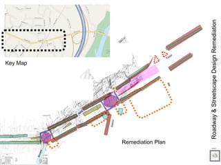
Oaks Gateway Traffic Calming
- 1. Roadway & Streetscape Design Remediation 2/10/11 Key Map Remediation Plan Station Gumbes Brower Mill Egypt
- 2. Deceleration Zone Dramatic speed limit signage and visual cues to slow down traffic as it enters the village Streetscape Amenities Gateways Architectural Structural features to frame transition zones & encourage controlled speeds. Oaks’ existing historic features, General Store, RR structures etc, should be the basis for the Station Ave gateway Nodes High-impact visual gateway for drivers carried out with pedestrian-safe boxes at Station and Brower Aves. Colored and textured crosswalks, countdown signals for pedestrians, median refuges, and pedestrian signage for drivers. etc, should be the basis for the Station Ave gateway Refuge & Planted Medians Protection, beautification, signage & lighting opportunities. Potential for integrating infiltration measures. Street Trees Street trees at proper intervals slow traffic, limit the heat island effect and minimize the impact of the widened roadway. Cultural/Historic Markers Ped. Safe Porkchop Islands Bulb-outs/Curb Extensions Reduce cartway to 9ft lanes @ gateway to neighborhood. Lighting & Signage Backlit signs to reduce req’d street lighting. Full cut off lighting Horizontal Offsets Legend