Neighbourhood analysis
•
1 like•1,093 views

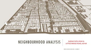
This document analyzes the Sardar Patel Road and Lattice Bridge Road neighborhood in Adyar, Chennai. It provides background on the development history and current land use of the area. The analysis includes proximity maps of healthcare, transportation, and density/economic activity. It examines traffic and pedestrian patterns at peak and non-peak hours. Details are given on the street elements and configuration of Sardar Patel Road. An open space analysis is also included. The document appears to be an assignment analyzing the landscape architecture and urban design of this neighborhood.
Report
Share
Report
Share
Download to read offline

Recommended
Gandhinagar,Gujarat,India- Urban Design for Student Architects.
Gandhinagar is the capital of Gujarat, India, located along the banks of the Sabarmati River. It was planned in the 1960s as the new capital after Gujarat split from Bombay state. The city was designed by Indian planners in a highly structured grid layout divided into 30 sectors. Gandhinagar remains one of the greenest and most planned cities in India due to its new development and emphasis on green spaces throughout the urban planning.
Jaipur City Planning - Urban Design
JAIPUR CITY URBAN DESIGN, ANALYSIS.
REPORT BASED ON THE PAPER:-
Space Formation of Jaipur City, Rajastan, India An
Analysis on City Maps (1925-28) made by Survey of
India
Shuji Funo, Naohiko Yamamoto & Mohan Pant
Theory Of Urban Design - Mental Map ,Serial Vision
Theories of Urban Design
Mental Map by Kevin Lynch
Serial Vision By gordon cullen
Public spaces by Jane Jacob
BROADACRE BY F.L. WRIGHT
Frank Lloyd Wright proposed Broadacre City, a decentralized urban concept, in the 1930s. It envisioned communities of single-family homes on one-acre plots connected by roads and public transport, with commercial areas integrated throughout. Wright believed this model would dissolve social failures by designing a better city structured around individual freedom and enabled by new technologies like cars. While never fully realized, aspects of Broadacre City can be seen in subsequent mid-20th century suburban development patterns in the United States.
Frank lloyd wright
Frank Lloyd Wright was an American architect known for his organic architecture and philosophy of designing structures in harmony with humanity and nature. He was interested in urban planning throughout his career. His most ambitious plan was Broadacre City, proposed in the 1930s, which envisioned decentralized, automobile-oriented communities where each American family would be given one acre of land. Broadacre City was meant to be the antithesis of dense cities and exemplify Wright's vision of suburban living, but it remained primarily a theoretical concept that highlighted some realities of future urban sprawl and independent living. While never fully realized, Broadacre City reflected Wright's belief that technological changes would make large cities obsolete.
Neighborhood concepts
- The document discusses two historical neighborhood concepts - Radburn neighborhood model by Stein and Wright, and Clarence Perry's neighborhood unit concept. Both aimed to design self-contained neighborhoods with boundaries, green spaces, and pedestrian-focused streets, though they differed in maximum walking distances and treatment as overlapping vs separate units.
- Neighborhoods are considered the basic building block of cities in planning, with the goal of improving social and physical environments. However, increased mobility has challenged the social benefits of neighborhoods.
- Contemporary developments often prioritize financial goals over unified social and physical environments, though neighborhoods remain important for decentralized, community-focused planning.
Case Study (Stockholm City)
The Stockholm City Plan from 1999 outlines the city's strategy to promote sustainable development through compact urban growth and preserving green spaces. The main points are:
1) The plan's overall strategy is to "build the city inwards" by focusing new development on previously used land and public transportation access.
2) An important part of the plan is defining and protecting an overall "green structure" of parks and natural areas that provide social, cultural, and ecological benefits.
3) Other goals include redeveloping former industrial areas, developing areas like Kista Science City, and enhancing suburban participation through programs like the Outer City initiative.
gandhinagar town planning literature study
Gandhinagar is the capital city of Gujarat, located 23 km north of Ahmedabad. It was planned in the 1960s after Ahmedabad became the capital of Gujarat following Partition. The city is built on land that was once part of the Pethapur state. It has a population of over 200,000 and a planned layout with sectors, roads aligned to avoid sun glare, and public buildings like the assembly hall near the center. Gandhinagar has good transportation links and is an administrative and economic hub of Gujarat.
Architecture and Planning of jaipur
Sawai Jai Singh II established the city of Jaipur in 1727, moving the capital from the congested hill town of Amber. Jaipur was planned according to Hindu texts on city planning, with a grid layout divided into nine wards by main streets oriented along the cardinal directions. This layout aligned with the site's geography, incorporating existing roads and a natural ridge line. The new capital strengthened the region's defenses and economy by its strategic location and planned design.
Determinants or Urban Form urban morphology
This document discusses urban morphology and the determinants of urban form. It begins by defining key terms like form, urban form, and urban morphology. It then describes the two main types of urban form - organic and grid oriented. The main determinants that shape urban form are described as natural (e.g. topography, climate) and man-made (e.g. political, religious, economic). Specific examples of each determinant are provided with images to illustrate how the determinant influenced the urban form. The document also includes a glossary defining terms commonly used in urban design like urban block, public realm, grain, and density.
Belapur Incremental housing - A case study
The document summarizes Charles Correa's incremental housing project in CBD Belapur, India. It describes the project's low-cost housing typologies designed around communal courtyards. Housing was organized into clusters of 7-12 pairs of freestanding homes arranged around shared spaces. This allowed residents to independently modify their own homes over time. While many original structures have been replaced, the hierarchy of community spaces remains intact decades later. The project demonstrated high-density affordable housing built at a human scale with simple materials. However, maintaining common spaces and adapting to changing aspirations have presented challenges over time.
Master Plan & Delhi Master Plan
This document summarizes the key aspects of a master plan submitted for a settlement. It discusses:
1. The need for master plans arose due to unplanned growth of cities following industrialization and wars, which led to overcrowding and lack of infrastructure.
2. A master plan is a statutory document that guides the orderly development of a city over a horizon year through land use planning and regulations. It addresses issues like transportation, housing, employment and provision of utilities and services.
3. The key components of the master plan submitted include analyses of the existing conditions, projected population and land requirements, and development proposals to organize land use and infrastructure over the plan period. It provides guidelines for implementation and monitoring of
Gandhinagar- Town Planning
INTRODUCTION
COORDINATES - 23.22 ON 72.680 E ELEVATION - 265 feet (81 m)*
LOCATED 23 KM NORTH OF AHEMDABAD (FIN CAP. OF GUJARAT)
PLANNED IN 1960S BY, PRAKASH M APTE & H. K. MEWADA,
AFTER PARTITION OF BOMBAY * STATE : AHEMDABAD WAS MADE AS THE CAPTAL OFGUJARAT
AREA TOTAL 177KM2 ELEVATION : 8IM ( 266 FT)
POPULATION (2011)
TOTAL: 206,167 DENSITY : 1,200/KM2
CLIMATE*
TROPICAL WET AND DRY CLIMATE•
SUMMER MAXIMUM - 36 to 42 °C MINIMUM - 19 to 27 C
WINTER MAXIMUM - 29 C MINIMUM - 14°C
MONSOON: THE AVERAGE ANNUAL RAINFALL IS AROUND 803.4 MM
LANGUAGES
GUJARATI, HINDI, AND ENGLISH• 54% GREEN COVER ON ITS LAND AREA
• THE CITY SITS ON THE BANKS OF THE SABARMATI RIVER, IN NORTH-CENTRALEAST GUJARAT
HISTORY
IN 1960, THE INDIAN STATE OF BOMBAY WAS SPLIT INTO TWO STATES, MAHARASHTRA AND GUJARAT LEAVING GUJARAT WITHOUT A CAPITAL CITY.
AT THE TIME AHMEDABAD WAS SELECTED TO BE THE FIRST CAPITAL OF THE NEWLY CREATED STATE.
• IT WAS LATER PROPOSED THAT A NEW CAPITAL CITY BE CONSTRUCTED FOR THE STATE.
• GANDHINAGAR GOT AN IDENTITY OF ITS OWN WHEN THE STATE OF MUMBAI WAS DIVIDED INTO TWO SEPARATE STATES OF GUJARAT AND MAHARASHTRA.
• IN THE BEGINNING, AHMEDABAD - A COMMERCIAL HUB OF GUJARAT WAS CHOSEN AS THE STATE CAPITAL AND IT WAS PROPOSED THAT A NEW CAPITAL SHOULD BE CONSTRUCTED ALONG THE LINE OF OTHER NEW STATE CAPITALS, PARTICULARLY CHANDIGARH
• THEREFORE TWO WELL-KNOWN INDIAN ARCHITECTS, H.K. MEWADA AND PRAKASH M. APTE (WHO WORKED AS BEGINNER FOR THE CHANDIGARH CITY) DESIGNED THE NEW STATE CAPITAL*
NAMED AFTER MAHATMA GANDHI THE FOUNDATION STONE OF THIS CITY WAS LAID ON 1965 AND IN 1971 THE CAPITAL WAS SHIFTED FROM AHMEDABAD TO GANDHINAGAR
PLANNING
• PLANNED AND IMPLEMENTED BETWEEN 1965-1970
• DETERMINATION TO MAKE GANDHINAGAR A PURELY INDIAN ENTERPRISE, PARTLY BECAUSE GUJARAT WAS THE BIRTHPLACE OF GANDHI.
• TO ESTABLISH AND MAINTAIN A SEPARATE IDENTITY FOR THE NEW CITY THE SURROUNDING AREA OF ABOUT 39 VILLAGES WAS BROUGHT UNDER A PERIPHERY CONTROL ACT (AS IN CHANDIGARH)
• THE AREA LATER CONSTITUTED A SEPARATE ADMINISTRATIVE DISTRICT OF GANDHINAGAR.
• THE CITY WAS PLANNED FOR A POPULATION OF 150,000 BUT CAN ACCOMMODATE DOUBLE THAT POPULATION WITH INCREASE IN THE FLOOR SPACE RATIO FROM 1 TO 2 IN THE AREAS RESERVED FOR PRIVATE DEVELOPMENT.
• THE RIVER BEING THE BORDER ON THE EAST, AND THE INDUSTRIAL AREA TO THE NORTH, THE MOST LOGICAL FUTURE PHYSICAL EXPANSION OF THE CITY WAS ENVISAGED TOWARDS THE NORTH-WEST
Urban conservation
Urban conservation techniques and strategies mainly followed in the INDIA.This is done for my friends in B.ARCH(VIIth semester) JNAFAU & JNTUK.
University.
Varanasi -town planning pdf
Background Study of varanasi , development of urban fabric in past and evolution of ghats. Study of Master plan 2011-2031 and different plans of city.
CITY PLANNING OF AHMEDABAD
The document provides a history of the city of Ahmedabad from its founding in the 13th century to present day. It began as a city called Karnavati on the banks of the Sabarmati River under Solanki dynasty rule. In the 14th-15th century under Sultanate rule, it was renamed Ahmedabad and established as the capital of Gujarat. The city grew as an important trade, textile and cultural center under Mughal rule in the 16th-17th century. After a period of decline in the 18th century under Maratha rule, the city saw rapid growth under British rule in the 19th century as an important trade center connected by new railways. After independence
Urban Design-Literature study St. Marks Road, Bangalore
Urban Planning
Literature study of St. Marks Road, Bangalore.
Includes:
1. Road Details
2. Survey Details & Analysis
3. Action Needed
4. Proposals
5. Action Made
6. Before & After Scenerio
7. Anatomy of Changes
Housing case study(KAFCO housing,Aranya lowcost housing, TARA housing)
The document discusses the Aranya housing project in Indore, India designed by architect Balkrishna Doshi. The project aimed to provide affordable housing for 6,500 low-income families on a 86 hectare site. Doshi's master plan created 6 sectors with distributed open spaces, mixed land uses, and pedestrian and vehicular segregation. The plan oriented buildings for optimal climate response. Housing units started as core structures that residents could incrementally expand based on need. The design focused on community interaction through shared spaces while allowing privacy.
Ews housing (2)
The document discusses a case study of an existing JnNURM EWS housing scheme in Jahangirpura, Surat to identify issues not considered. It aims to develop a design for the housing that is sensitive to identified issues and enables cost-effective construction through modular repetition. Key points discussed include:
- Migration trends leading to growth of slums in Surat and relocation efforts under JnNURM schemes.
- Standards and guidelines for EWS housing in Surat, including unit sizes, densities, and costs.
- Status of existing slum settlements and living conditions of slum residents in Surat.
- Outcomes expected from JnNURM schemes, including
Neighbourhood-Planning--Design-Standards-combined-June-2015
The document discusses building great neighbourhoods in Red Deer through careful planning and design. It outlines nine principles for creating neighbourhoods that are sustainable, walkable, vibrant, and livable. These include considering natural areas, a mix of land uses, connectivity through various transportation options, compact urban form and density, parks and community spaces, housing variety, resilience and sustainability, safety, and unique identity. The standards provide guidance for both new neighbourhood developments and smaller redevelopment within existing areas to achieve well-designed neighbourhoods that improve quality of life.
George town as a core city
George Town is the historic core area of Chennai that has experienced traffic congestion, poor infrastructure, and lack of land due to commercial activities and narrow streets. The Chennai Metropolitan Development Authority has undertaken several redevelopment strategies for George Town, including removing encroachments, shifting wholesale markets to Koyambedu to reduce congestion, and road widening projects while protecting heritage buildings. Lessons for redeveloping other congested areas include promoting mixed land use and improving infrastructure.
Neighbourhood Planning
The document discusses the principles and concepts of neighborhood planning. It explains that neighborhood planning aims to create small residential units of 2,000-5,000 people to foster a sense of community. Key aspects of neighborhood planning include limiting the size to a walkable area, using boundary roads, incorporating green spaces, designing internal streets for safety, providing a mix of housing, locating shops and community centers in central areas, and including facilities like schools and parks within 1 km to encourage social life. The principles of neighborhood planning aim to balance residential development with community spaces and recreation to recreate the lost neighborhood relationships of modern cities.
46721953 magarpatta-city
Magarpatta City is an integrated township development project covering 400 acres near Pune, India. It was conceptualized by Satish Magar as a partnership between himself and 120 local farmers, who pooled their agricultural lands and became equity shareholders in proportion to the land contributed. The project was planned and developed in phases from 1993 to the present, including over 7,500 residential units of various types, large commercial areas like an IT park and mall, and amenities to support a population of 60,000. The innovative development model provided significant financial gains for the farmer partners and helped curb unplanned urban growth.
60782357 final-case-study-0506
This document summarizes a case study report on affordable housing development models in Gujarat and Rajasthan. It discusses:
1) Gujarat's EWS housing scheme where the Ahmedabad Urban Development Authority uses a town planning scheme to develop affordable housing, reserving land and constructing units which are then allotted through a lottery system.
2) A specific EWS project in Ahmedabad consisting of over 5000 units developed on a town planning scheme site.
3) Rajasthan's affordable housing policy that promotes EWS/LIG development through public-private partnerships, offering incentives to private developers to construct affordable units.
Acrosanti
The document discusses urban planning and new urbanism principles. It summarizes Paolo Soleri's Arcosanti, an experimental urban planning project in Arizona that aims to embody the principles of arcology - the fusion of architecture and ecology. The key goals of arcology include increasing density and compactness to minimize environmental impact. New urbanism is also summarized as a movement promoting walkable, diverse neighborhoods with mixed uses. Its principles include walkability, connectivity, density and mixed housing. Traffic and road networks are classified, including different transport systems like rail, road, water and air transport. Road types and traffic surveys are also defined.
ARCHITECTURE THESIS 1
A student named Ling Teck Ong submitted their portfolio for an architectural design thesis course at University Tunku Abdul Rahman. The portfolio contained scale models of the site at 1:1000 scale and the proposed design at 1:300 scale. The student's portfolio was submitted to fulfill the requirements for the MEAP26108 Architectural Design Thesis 1 course in the second year of studies.
Camillo sitte - Urban designer
CAMILLO SITTE
He was an Austrian architect, born Vienna in 1843
Camillo Sitte was the son of the architect Franz Sitte(1808–79) and the father of the architect Siegfried Sitte (1876–1945).
He was an art historian and architect whose writings, according to Eliel Saarinen, were familiar to German-speaking architects of the late 19th century.
He was also an painter and urban theorist whose work influenced urban planning and land use regulation.
Sitte traveled extensively in Western Europe, seeking to identify the factors that made certain towns feel warm and welcoming.
Sitte saw architecture was a process and product of culture.
BOOKS BY SITTE-
1. City Planning According to Artistic Principles, 1889
2. The Birth of Modern City Planning. Dover Publications, 2006.
CYCLE 03_Public Participation at Various Scale in india.pdf
The document discusses public participation in urban planning at various scales in India. It provides an overview of the hierarchical urban planning system in India, from master plans at the city level down to local area plans, sector plans, and layout plans. It notes that traditionally, urban planning has been a top-down process but that public participation is now seen as important for making planning more demand-driven. The document then examines models of participation at different levels and the challenges of enhancing participation in India's diverse urban contexts.
ADAPTIVE REUSE_CASE STUDIES.pdf
The document discusses several case studies of adaptive reuse projects from around the world:
1) The renovation and extension of the Pier Arts Centre in Scotland that connected two historic buildings with a new modern addition.
2) The conversion of a ruined armory in Germany into a cafeteria that used glass and steel to integrate into the ruin.
3) The transformation of a former customs hall in Venice into a museum by Japanese architect Tadao Ando who contrasted polished concrete with the original brick.
4) A former railway station in Brussels that was converted into a timber shopping center using over 10,000 cubic meters of cross-laminated timber.
More Related Content
What's hot
Architecture and Planning of jaipur
Sawai Jai Singh II established the city of Jaipur in 1727, moving the capital from the congested hill town of Amber. Jaipur was planned according to Hindu texts on city planning, with a grid layout divided into nine wards by main streets oriented along the cardinal directions. This layout aligned with the site's geography, incorporating existing roads and a natural ridge line. The new capital strengthened the region's defenses and economy by its strategic location and planned design.
Determinants or Urban Form urban morphology
This document discusses urban morphology and the determinants of urban form. It begins by defining key terms like form, urban form, and urban morphology. It then describes the two main types of urban form - organic and grid oriented. The main determinants that shape urban form are described as natural (e.g. topography, climate) and man-made (e.g. political, religious, economic). Specific examples of each determinant are provided with images to illustrate how the determinant influenced the urban form. The document also includes a glossary defining terms commonly used in urban design like urban block, public realm, grain, and density.
Belapur Incremental housing - A case study
The document summarizes Charles Correa's incremental housing project in CBD Belapur, India. It describes the project's low-cost housing typologies designed around communal courtyards. Housing was organized into clusters of 7-12 pairs of freestanding homes arranged around shared spaces. This allowed residents to independently modify their own homes over time. While many original structures have been replaced, the hierarchy of community spaces remains intact decades later. The project demonstrated high-density affordable housing built at a human scale with simple materials. However, maintaining common spaces and adapting to changing aspirations have presented challenges over time.
Master Plan & Delhi Master Plan
This document summarizes the key aspects of a master plan submitted for a settlement. It discusses:
1. The need for master plans arose due to unplanned growth of cities following industrialization and wars, which led to overcrowding and lack of infrastructure.
2. A master plan is a statutory document that guides the orderly development of a city over a horizon year through land use planning and regulations. It addresses issues like transportation, housing, employment and provision of utilities and services.
3. The key components of the master plan submitted include analyses of the existing conditions, projected population and land requirements, and development proposals to organize land use and infrastructure over the plan period. It provides guidelines for implementation and monitoring of
Gandhinagar- Town Planning
INTRODUCTION
COORDINATES - 23.22 ON 72.680 E ELEVATION - 265 feet (81 m)*
LOCATED 23 KM NORTH OF AHEMDABAD (FIN CAP. OF GUJARAT)
PLANNED IN 1960S BY, PRAKASH M APTE & H. K. MEWADA,
AFTER PARTITION OF BOMBAY * STATE : AHEMDABAD WAS MADE AS THE CAPTAL OFGUJARAT
AREA TOTAL 177KM2 ELEVATION : 8IM ( 266 FT)
POPULATION (2011)
TOTAL: 206,167 DENSITY : 1,200/KM2
CLIMATE*
TROPICAL WET AND DRY CLIMATE•
SUMMER MAXIMUM - 36 to 42 °C MINIMUM - 19 to 27 C
WINTER MAXIMUM - 29 C MINIMUM - 14°C
MONSOON: THE AVERAGE ANNUAL RAINFALL IS AROUND 803.4 MM
LANGUAGES
GUJARATI, HINDI, AND ENGLISH• 54% GREEN COVER ON ITS LAND AREA
• THE CITY SITS ON THE BANKS OF THE SABARMATI RIVER, IN NORTH-CENTRALEAST GUJARAT
HISTORY
IN 1960, THE INDIAN STATE OF BOMBAY WAS SPLIT INTO TWO STATES, MAHARASHTRA AND GUJARAT LEAVING GUJARAT WITHOUT A CAPITAL CITY.
AT THE TIME AHMEDABAD WAS SELECTED TO BE THE FIRST CAPITAL OF THE NEWLY CREATED STATE.
• IT WAS LATER PROPOSED THAT A NEW CAPITAL CITY BE CONSTRUCTED FOR THE STATE.
• GANDHINAGAR GOT AN IDENTITY OF ITS OWN WHEN THE STATE OF MUMBAI WAS DIVIDED INTO TWO SEPARATE STATES OF GUJARAT AND MAHARASHTRA.
• IN THE BEGINNING, AHMEDABAD - A COMMERCIAL HUB OF GUJARAT WAS CHOSEN AS THE STATE CAPITAL AND IT WAS PROPOSED THAT A NEW CAPITAL SHOULD BE CONSTRUCTED ALONG THE LINE OF OTHER NEW STATE CAPITALS, PARTICULARLY CHANDIGARH
• THEREFORE TWO WELL-KNOWN INDIAN ARCHITECTS, H.K. MEWADA AND PRAKASH M. APTE (WHO WORKED AS BEGINNER FOR THE CHANDIGARH CITY) DESIGNED THE NEW STATE CAPITAL*
NAMED AFTER MAHATMA GANDHI THE FOUNDATION STONE OF THIS CITY WAS LAID ON 1965 AND IN 1971 THE CAPITAL WAS SHIFTED FROM AHMEDABAD TO GANDHINAGAR
PLANNING
• PLANNED AND IMPLEMENTED BETWEEN 1965-1970
• DETERMINATION TO MAKE GANDHINAGAR A PURELY INDIAN ENTERPRISE, PARTLY BECAUSE GUJARAT WAS THE BIRTHPLACE OF GANDHI.
• TO ESTABLISH AND MAINTAIN A SEPARATE IDENTITY FOR THE NEW CITY THE SURROUNDING AREA OF ABOUT 39 VILLAGES WAS BROUGHT UNDER A PERIPHERY CONTROL ACT (AS IN CHANDIGARH)
• THE AREA LATER CONSTITUTED A SEPARATE ADMINISTRATIVE DISTRICT OF GANDHINAGAR.
• THE CITY WAS PLANNED FOR A POPULATION OF 150,000 BUT CAN ACCOMMODATE DOUBLE THAT POPULATION WITH INCREASE IN THE FLOOR SPACE RATIO FROM 1 TO 2 IN THE AREAS RESERVED FOR PRIVATE DEVELOPMENT.
• THE RIVER BEING THE BORDER ON THE EAST, AND THE INDUSTRIAL AREA TO THE NORTH, THE MOST LOGICAL FUTURE PHYSICAL EXPANSION OF THE CITY WAS ENVISAGED TOWARDS THE NORTH-WEST
Urban conservation
Urban conservation techniques and strategies mainly followed in the INDIA.This is done for my friends in B.ARCH(VIIth semester) JNAFAU & JNTUK.
University.
Varanasi -town planning pdf
Background Study of varanasi , development of urban fabric in past and evolution of ghats. Study of Master plan 2011-2031 and different plans of city.
CITY PLANNING OF AHMEDABAD
The document provides a history of the city of Ahmedabad from its founding in the 13th century to present day. It began as a city called Karnavati on the banks of the Sabarmati River under Solanki dynasty rule. In the 14th-15th century under Sultanate rule, it was renamed Ahmedabad and established as the capital of Gujarat. The city grew as an important trade, textile and cultural center under Mughal rule in the 16th-17th century. After a period of decline in the 18th century under Maratha rule, the city saw rapid growth under British rule in the 19th century as an important trade center connected by new railways. After independence
Urban Design-Literature study St. Marks Road, Bangalore
Urban Planning
Literature study of St. Marks Road, Bangalore.
Includes:
1. Road Details
2. Survey Details & Analysis
3. Action Needed
4. Proposals
5. Action Made
6. Before & After Scenerio
7. Anatomy of Changes
Housing case study(KAFCO housing,Aranya lowcost housing, TARA housing)
The document discusses the Aranya housing project in Indore, India designed by architect Balkrishna Doshi. The project aimed to provide affordable housing for 6,500 low-income families on a 86 hectare site. Doshi's master plan created 6 sectors with distributed open spaces, mixed land uses, and pedestrian and vehicular segregation. The plan oriented buildings for optimal climate response. Housing units started as core structures that residents could incrementally expand based on need. The design focused on community interaction through shared spaces while allowing privacy.
Ews housing (2)
The document discusses a case study of an existing JnNURM EWS housing scheme in Jahangirpura, Surat to identify issues not considered. It aims to develop a design for the housing that is sensitive to identified issues and enables cost-effective construction through modular repetition. Key points discussed include:
- Migration trends leading to growth of slums in Surat and relocation efforts under JnNURM schemes.
- Standards and guidelines for EWS housing in Surat, including unit sizes, densities, and costs.
- Status of existing slum settlements and living conditions of slum residents in Surat.
- Outcomes expected from JnNURM schemes, including
Neighbourhood-Planning--Design-Standards-combined-June-2015
The document discusses building great neighbourhoods in Red Deer through careful planning and design. It outlines nine principles for creating neighbourhoods that are sustainable, walkable, vibrant, and livable. These include considering natural areas, a mix of land uses, connectivity through various transportation options, compact urban form and density, parks and community spaces, housing variety, resilience and sustainability, safety, and unique identity. The standards provide guidance for both new neighbourhood developments and smaller redevelopment within existing areas to achieve well-designed neighbourhoods that improve quality of life.
George town as a core city
George Town is the historic core area of Chennai that has experienced traffic congestion, poor infrastructure, and lack of land due to commercial activities and narrow streets. The Chennai Metropolitan Development Authority has undertaken several redevelopment strategies for George Town, including removing encroachments, shifting wholesale markets to Koyambedu to reduce congestion, and road widening projects while protecting heritage buildings. Lessons for redeveloping other congested areas include promoting mixed land use and improving infrastructure.
Neighbourhood Planning
The document discusses the principles and concepts of neighborhood planning. It explains that neighborhood planning aims to create small residential units of 2,000-5,000 people to foster a sense of community. Key aspects of neighborhood planning include limiting the size to a walkable area, using boundary roads, incorporating green spaces, designing internal streets for safety, providing a mix of housing, locating shops and community centers in central areas, and including facilities like schools and parks within 1 km to encourage social life. The principles of neighborhood planning aim to balance residential development with community spaces and recreation to recreate the lost neighborhood relationships of modern cities.
46721953 magarpatta-city
Magarpatta City is an integrated township development project covering 400 acres near Pune, India. It was conceptualized by Satish Magar as a partnership between himself and 120 local farmers, who pooled their agricultural lands and became equity shareholders in proportion to the land contributed. The project was planned and developed in phases from 1993 to the present, including over 7,500 residential units of various types, large commercial areas like an IT park and mall, and amenities to support a population of 60,000. The innovative development model provided significant financial gains for the farmer partners and helped curb unplanned urban growth.
60782357 final-case-study-0506
This document summarizes a case study report on affordable housing development models in Gujarat and Rajasthan. It discusses:
1) Gujarat's EWS housing scheme where the Ahmedabad Urban Development Authority uses a town planning scheme to develop affordable housing, reserving land and constructing units which are then allotted through a lottery system.
2) A specific EWS project in Ahmedabad consisting of over 5000 units developed on a town planning scheme site.
3) Rajasthan's affordable housing policy that promotes EWS/LIG development through public-private partnerships, offering incentives to private developers to construct affordable units.
Acrosanti
The document discusses urban planning and new urbanism principles. It summarizes Paolo Soleri's Arcosanti, an experimental urban planning project in Arizona that aims to embody the principles of arcology - the fusion of architecture and ecology. The key goals of arcology include increasing density and compactness to minimize environmental impact. New urbanism is also summarized as a movement promoting walkable, diverse neighborhoods with mixed uses. Its principles include walkability, connectivity, density and mixed housing. Traffic and road networks are classified, including different transport systems like rail, road, water and air transport. Road types and traffic surveys are also defined.
ARCHITECTURE THESIS 1
A student named Ling Teck Ong submitted their portfolio for an architectural design thesis course at University Tunku Abdul Rahman. The portfolio contained scale models of the site at 1:1000 scale and the proposed design at 1:300 scale. The student's portfolio was submitted to fulfill the requirements for the MEAP26108 Architectural Design Thesis 1 course in the second year of studies.
Camillo sitte - Urban designer
CAMILLO SITTE
He was an Austrian architect, born Vienna in 1843
Camillo Sitte was the son of the architect Franz Sitte(1808–79) and the father of the architect Siegfried Sitte (1876–1945).
He was an art historian and architect whose writings, according to Eliel Saarinen, were familiar to German-speaking architects of the late 19th century.
He was also an painter and urban theorist whose work influenced urban planning and land use regulation.
Sitte traveled extensively in Western Europe, seeking to identify the factors that made certain towns feel warm and welcoming.
Sitte saw architecture was a process and product of culture.
BOOKS BY SITTE-
1. City Planning According to Artistic Principles, 1889
2. The Birth of Modern City Planning. Dover Publications, 2006.
What's hot (20)
Urban Design-Literature study St. Marks Road, Bangalore
Urban Design-Literature study St. Marks Road, Bangalore
Housing case study(KAFCO housing,Aranya lowcost housing, TARA housing)
Housing case study(KAFCO housing,Aranya lowcost housing, TARA housing)
Neighbourhood-Planning--Design-Standards-combined-June-2015
Neighbourhood-Planning--Design-Standards-combined-June-2015
More from Geeva Chandana
CYCLE 03_Public Participation at Various Scale in india.pdf
The document discusses public participation in urban planning at various scales in India. It provides an overview of the hierarchical urban planning system in India, from master plans at the city level down to local area plans, sector plans, and layout plans. It notes that traditionally, urban planning has been a top-down process but that public participation is now seen as important for making planning more demand-driven. The document then examines models of participation at different levels and the challenges of enhancing participation in India's diverse urban contexts.
ADAPTIVE REUSE_CASE STUDIES.pdf
The document discusses several case studies of adaptive reuse projects from around the world:
1) The renovation and extension of the Pier Arts Centre in Scotland that connected two historic buildings with a new modern addition.
2) The conversion of a ruined armory in Germany into a cafeteria that used glass and steel to integrate into the ruin.
3) The transformation of a former customs hall in Venice into a museum by Japanese architect Tadao Ando who contrasted polished concrete with the original brick.
4) A former railway station in Brussels that was converted into a timber shopping center using over 10,000 cubic meters of cross-laminated timber.
ADAPTIVE REUSE_Introduction.pdf
The document discusses adaptive reuse, which refers to reconstructing or reusing existing buildings for purposes other than their original design. This process provides environmental and economic benefits. Some advantages of adaptive reuse include energy conservation, supporting sustainability, enhancing community character, encouraging investment, and cost savings compared to new construction. Successful adaptive reuse projects consider the building's condition and suitability for the new purpose. They also address any physical, regulatory or environmental limitations. The types of abandoned buildings most suitable for adaptive reuse tend to be industrial, political, or community buildings in cities. Terminologies like retrofitting, refurbishment and rehabilitation are used for adaptive reuse projects depending on the work conducted.
UNIT 04_URBAN LANDSCAPE.pdf
The document discusses the key elements and principles of landscape architecture and urban landscape design. It covers 5 units that introduce landscape architecture, elements of landscape design, the history of landscape architecture, urban landscape principles, and a landscape exercise. It also provides details on the benefits of urban landscapes, including environmental, social, health, and economic benefits. The document emphasizes creating sustainable, accessible, and equitable landscapes through community involvement.
Drafting techniques in Building Materials and Construction
The document discusses guidelines for line weights in architectural drafting. It recommends using light lines like HB or 2H pencil for construction lines. Bold lines like B or 2B pencil should be used for primary objects like walls. Medium lines like H pencil are for secondary objects inside bold lines. Light lines like H or 2H are used for action lines, information lines, and fill patterns. The document also covers line types and common architectural symbols used for materials, doors, windows, and scales for drawings.
Components of building - Building Materials and Construction
This document provides an overview of a course on building materials and construction. It discusses key building elements like foundations, walls, floors, roofs, and stairs. It introduces natural building materials like rocks, stones, soil, bamboo, and straw bales. It covers the classification, properties and uses of various types of stones and soils. The document also discusses drafting techniques like line weights, line types, and architectural graphic symbols. Building material selection and architectural scale drawings are also summarized.
Bamboo - Building Materials and Construction
The document is a presentation about bamboo as a building material. It discusses bamboo's classification as a type of grass, its fast growth rate and worldwide geographical distribution. The anatomy, properties, harvesting, processing and uses of bamboo are described. Bamboo has many advantages as a building material such as strength, renewability, and versatility. Common types of bamboo found in India are described along with their suitable habitats and uses. Methods for treating, seasoning, and joining bamboo are also outlined.
Strawbales - Building Materials and Construction
The document discusses the use of straw as a building material. It describes how straw bale construction uses baled straw stacked in walls and covered with earthen or lime stucco. Straw is also used as sheathing, wall panels, and to bind clay and concrete. The document outlines the physical properties of straw construction, including its use as insulation and soundproofing. It also discusses potential issues with moisture, mold, fire, and pests, and how to address these issues.
Stone and rocks - Building Materials and Construction
This document discusses rocks and stones used in construction. It begins by classifying rocks based on their geological formation (igneous, sedimentary, metamorphic), physical texture (stratified, unstratified, foliated), and chemical composition (siliceous, argillaceous, calcareous). It then describes the sources, quarrying, dressing, and seasoning of stones. Common building stones are discussed along with their characteristics, uses, testing, artificial stones, and factors that affect durability. The document provides an overview of different rock and stone types used in construction materials.
Soil - Building Materials and Construction
The document provides information about soil and its use in construction. It discusses the key components of soil including minerals, water, air and organic matter. It then describes the five factors that influence soil formation: parent materials, weathering, organic matter, topography and time. The document outlines different soil types based on particle size such as gravel, sand, silt and clay. It discusses principles of soil stabilization including increasing density, adding stabilizing agents, and improving properties like strength and shrinkage resistance. Finally, it briefly mentions different techniques for mud wall construction like cob, rammed earth and adobe.
Unit 03 History of Landscape Architecture
The document provides an overview of five units covering the topic of landscape architecture. Unit 1 introduces key concepts like ecology, conservation, and environmental impact assessment. Unit 2 discusses landscape elements, plant materials, and landscape design principles. Unit 3 covers the history of landscape architecture from ancient Eastern and Western traditions to modern times. Unit 4 addresses urban landscape design principles. Finally, Unit 5 describes a landscape exercise involving the design of an open neighborhood space.
Unit 02 Elements of Landscape Architecture and Landscape Design
This document provides an overview of the key elements and concepts in landscape architecture. It discusses landscape architecture, landforms, planting design, water features, and urban landscapes. The document is divided into 5 units that cover the introduction to landscape architecture, elements of landscape design, history of landscape architecture, urban landscapes, and landscape exercises. It also provides details on landforms, contour lines, ridge and valley systems, watersheds, vegetation, and planting design principles.
Unit 01 An Introduction to Landscape Architecture
The document is a presentation on landscape architecture by Ar. Geeva Chandana. It covers 5 units: introduction to landscape architecture, elements of landscape design, history of landscape architecture, urban landscape, and a landscape exercise. It discusses concepts like landscape, landscaping, landscape architecture. It outlines factors to consider in landscape design like maintenance, plant selection. It shows how landscape architecture can be used to enhance spaces, connect with nature, and narrate history.
Toilet and Bath Working Drawing
The document provides guidance on designing bathrooms and toilets. It discusses the five basic steps in bath design which include gathering information, setting priorities, selecting products, doing layout and design, and creating a checklist. It also provides details on space planning, fixtures, lighting, textures, and standard dimensions for clearances, turning radii, and shower and tub sizes. Dimensioned drawings are shown for toilet plans, elevations and details.
Kitchen Working Drawing
The document provides guidelines for designing a kitchen space, including:
- Analyzing how the kitchen relates to the overall house and creating a bubble plan based on family usage.
- Selecting appliances, plumbing fixtures, and cabinetry based on needs and ergonomic considerations.
- Planning storage, lighting, ventilation, finishes, and ensuring the design meets ergonomic and accessibility standards.
- Referencing standard kitchen dimensions for cabinets, countertops, appliances, and fixtures.
Toilet and Bath Working Drawing
The document provides guidance on designing bathrooms and toilets, including considerations for space planning, safety, accessibility, and building codes. It outlines five basic steps for bath design: gathering information, setting priorities, researching products, design and layout, and creating a checklist. Key aspects of bathroom design covered include establishing design goals, analyzing the space, selecting plumbing fixtures, planning for lighting, textures, and mechanical systems, and ensuring adequate clearances and wheelchair accessibility. Standard dimensions and other technical specifications are provided for bathroom components and fixtures.
Fractals in architecture
Fractals are geometric shapes that can be split into parts, with each part being a reduced-size copy of the whole. They display self-similarity on all scales and exist abundantly in nature, the human body, and outer space. Fractals have also been used in architecture and planning since prehistory.
Concept ,Case study and Literature Study
The document discusses architectural concepts and case studies. It defines concepts as abstract ideas that can evolve throughout the design process. Concepts help architects translate non-physical design problems into physical buildings. Functional concepts solve design problems logically, while artistic concepts draw inspiration from other art forms. The document provides examples of architectural projects with functional or artistic concepts. It also discusses developing concepts through site analysis, brainstorming, and being inspired by nature, forms, or other architecture. Case studies are defined as in-depth investigations of individuals, groups, or communities that can help designers understand aspects to consider.
Theory of architecture unit 05
This document provides an overview of principles of architecture presented by Ar. Geeva Chandana. It discusses key principles such as proportion, scale, balance, symmetry/asymmetry, rhythm, axis, hierarchy, and movement. Proportion is examined through various theories including the golden section, classical orders, Renaissance theories, and anthropometry. Scale and its relationship to proportion is also explored. Examples are given to illustrate concepts of balance, axis, symmetry, hierarchy, and rhythm. The document aims to help understand fundamental architectural principles and their application in form, space, and structure.
Theory of architecture unit 04
This document discusses different types of architectural space and spatial organizations. It describes enclosure as using four vertical planes to define a space. The degree of enclosure impacts spatial perception. Common spatial relationships include spaces within spaces, adjacent spaces, interlocking spaces, and spaces linked by a common intermediate space. Key spatial organizations are centralized around a central space, linear as a sequence, radial extending from a center, and clustered grouping similar spaces.
More from Geeva Chandana (20)
CYCLE 03_Public Participation at Various Scale in india.pdf
CYCLE 03_Public Participation at Various Scale in india.pdf
Drafting techniques in Building Materials and Construction
Drafting techniques in Building Materials and Construction
Components of building - Building Materials and Construction
Components of building - Building Materials and Construction
Stone and rocks - Building Materials and Construction
Stone and rocks - Building Materials and Construction
Unit 02 Elements of Landscape Architecture and Landscape Design
Unit 02 Elements of Landscape Architecture and Landscape Design
Recently uploaded
一比一原版(USQ毕业证书)南昆士兰大学毕业证如何办理
原件一模一样【微信:WP101A】【(USQ毕业证书)南昆士兰大学毕业证学位证成绩单】【微信:WP101A】(留信学历认证永久存档查询)采用学校原版纸张、特殊工艺完全按照原版一比一制作(包括:隐形水印,阴影底纹,钢印LOGO烫金烫银,LOGO烫金烫银复合重叠,文字图案浮雕,激光镭射,紫外荧光,温感,复印防伪)行业标杆!精益求精,诚心合作,真诚制作!多年品质 ,按需精细制作,24小时接单,全套进口原装设备,十五年致力于帮助留学生解决难题,业务范围有加拿大、英国、澳洲、韩国、美国、新加坡,新西兰等学历材料,包您满意。
【业务选择办理准则】
一、工作未确定,回国需先给父母、亲戚朋友看下文凭的情况,办理一份就读学校的毕业证【微信:WP101A】文凭即可
二、回国进私企、外企、自己做生意的情况,这些单位是不查询毕业证真伪的,而且国内没有渠道去查询国外文凭的真假,也不需要提供真实教育部认证。鉴于此,办理一份毕业证【微信:WP101A】即可
三、进国企,银行,事业单位,考公务员等等,这些单位是必需要提供真实教育部认证的,办理教育部认证所需资料众多且烦琐,所有材料您都必须提供原件,我们凭借丰富的经验,快捷的绿色通道帮您快速整合材料,让您少走弯路。
留信网认证的作用:
1:该专业认证可证明留学生真实身份【微信:WP101A】
2:同时对留学生所学专业登记给予评定
3:国家专业人才认证中心颁发入库证书
4:这个认证书并且可以归档倒地方
5:凡事获得留信网入网的信息将会逐步更新到个人身份内,将在公安局网内查询个人身份证信息后,同步读取人才网入库信息
6:个人职称评审加20分
7:个人信誉贷款加10分
8:在国家人才网主办的国家网络招聘大会中纳入资料,供国家高端企业选择人才
→ 【关于价格问题(保证一手价格)
我们所定的价格是非常合理的,而且我们现在做得单子大多数都是代理和回头客户介绍的所以一般现在有新的单子 我给客户的都是第一手的代理价格,因为我想坦诚对待大家 不想跟大家在价格方面浪费时间
对于老客户或者被老客户介绍过来的朋友,我们都会适当给一些优惠。
选择实体注册公司办理,更放心,更安全!我们的承诺:可来公司面谈,可签订合同,会陪同客户一起到教育部认证窗口递交认证材料,客户在教育部官方认证查询网站查询到认证通过结果后付款,不成功不收费!
办理(USQ毕业证书)南昆士兰大学毕业证学位证【微信:WP101A 】外观非常精致,由特殊纸质材料制成,上面印有校徽、校名、毕业生姓名、专业等信息。
办理(USQ毕业证书)南昆士兰大学毕业证学位证【微信:WP101A 】格式相对统一,各专业都有相应的模板。通常包括以下部分:
校徽:象征着学校的荣誉和传承。
校名:学校英文全称
授予学位:本部分将注明获得的具体学位名称。
毕业生姓名:这是最重要的信息之一,标志着该证书是由特定人员获得的。
颁发日期:这是毕业正式生效的时间,也代表着毕业生学业的结束。
其他信息:根据不同的专业和学位,可能会有一些特定的信息或章节。
办理(USQ毕业证书)南昆士兰大学毕业证学位证【微信:WP101A 】价值很高,需要妥善保管。一般来说,应放置在安全、干燥、防潮的地方,避免长时间暴露在阳光下。如需使用,最好使用复印件而不是原件,以免丢失。
综上所述,办理(USQ毕业证书)南昆士兰大学毕业证学位证【微信:WP101A 】是证明身份和学历的高价值文件。外观简单庄重,格式统一,包括重要的个人信息和发布日期。对持有人来说,妥善保管是非常重要的。
一比一原版澳洲查理斯特大学毕业证(CSU学位证)如何办理
原件一模一样【微信:WP101A】【澳洲查理斯特大学毕业证(CSU学位证)成绩单】【微信:WP101A】(留信学历认证永久存档查询)采用学校原版纸张、特殊工艺完全按照原版一比一制作(包括:隐形水印,阴影底纹,钢印LOGO烫金烫银,LOGO烫金烫银复合重叠,文字图案浮雕,激光镭射,紫外荧光,温感,复印防伪)行业标杆!精益求精,诚心合作,真诚制作!多年品质 ,按需精细制作,24小时接单,全套进口原装设备,十五年致力于帮助留学生解决难题,业务范围有加拿大、英国、澳洲、韩国、美国、新加坡,新西兰等学历材料,包您满意。
【业务选择办理准则】
一、工作未确定,回国需先给父母、亲戚朋友看下文凭的情况,办理一份就读学校的毕业证【微信:WP101A】文凭即可
二、回国进私企、外企、自己做生意的情况,这些单位是不查询毕业证真伪的,而且国内没有渠道去查询国外文凭的真假,也不需要提供真实教育部认证。鉴于此,办理一份毕业证【微信:WP101A】即可
三、进国企,银行,事业单位,考公务员等等,这些单位是必需要提供真实教育部认证的,办理教育部认证所需资料众多且烦琐,所有材料您都必须提供原件,我们凭借丰富的经验,快捷的绿色通道帮您快速整合材料,让您少走弯路。
留信网认证的作用:
1:该专业认证可证明留学生真实身份【微信:WP101A】
2:同时对留学生所学专业登记给予评定
3:国家专业人才认证中心颁发入库证书
4:这个认证书并且可以归档倒地方
5:凡事获得留信网入网的信息将会逐步更新到个人身份内,将在公安局网内查询个人身份证信息后,同步读取人才网入库信息
6:个人职称评审加20分
7:个人信誉贷款加10分
8:在国家人才网主办的国家网络招聘大会中纳入资料,供国家高端企业选择人才
→ 【关于价格问题(保证一手价格)
我们所定的价格是非常合理的,而且我们现在做得单子大多数都是代理和回头客户介绍的所以一般现在有新的单子 我给客户的都是第一手的代理价格,因为我想坦诚对待大家 不想跟大家在价格方面浪费时间
对于老客户或者被老客户介绍过来的朋友,我们都会适当给一些优惠。
选择实体注册公司办理,更放心,更安全!我们的承诺:可来公司面谈,可签订合同,会陪同客户一起到教育部认证窗口递交认证材料,客户在教育部官方认证查询网站查询到认证通过结果后付款,不成功不收费!
办理澳洲查理斯特大学毕业证(CSU学位证)学位证【微信:WP101A 】外观非常精致,由特殊纸质材料制成,上面印有校徽、校名、毕业生姓名、专业等信息。
办理澳洲查理斯特大学毕业证(CSU学位证)学位证【微信:WP101A 】格式相对统一,各专业都有相应的模板。通常包括以下部分:
校徽:象征着学校的荣誉和传承。
校名:学校英文全称
授予学位:本部分将注明获得的具体学位名称。
毕业生姓名:这是最重要的信息之一,标志着该证书是由特定人员获得的。
颁发日期:这是毕业正式生效的时间,也代表着毕业生学业的结束。
其他信息:根据不同的专业和学位,可能会有一些特定的信息或章节。
办理澳洲查理斯特大学毕业证(CSU学位证)学位证【微信:WP101A 】价值很高,需要妥善保管。一般来说,应放置在安全、干燥、防潮的地方,避免长时间暴露在阳光下。如需使用,最好使用复印件而不是原件,以免丢失。
综上所述,办理澳洲查理斯特大学毕业证(CSU学位证)学位证【微信:WP101A 】是证明身份和学历的高价值文件。外观简单庄重,格式统一,包括重要的个人信息和发布日期。对持有人来说,妥善保管是非常重要的。
一比一原版(ucb毕业证书)英国伯明翰大学学院毕业证如何办理
原版一模一样【微信:741003700 】【(ucb毕业证书)英国伯明翰大学学院毕业证成绩单】【微信:741003700 】学位证,留信认证(真实可查,永久存档)原件一模一样纸张工艺/offer、雅思、外壳等材料/诚信可靠,可直接看成品样本,帮您解决无法毕业带来的各种难题!外壳,原版制作,诚信可靠,可直接看成品样本。行业标杆!精益求精,诚心合作,真诚制作!多年品质 ,按需精细制作,24小时接单,全套进口原装设备。十五年致力于帮助留学生解决难题,包您满意。
本公司拥有海外各大学样板无数,能完美还原。
1:1完美还原海外各大学毕业材料上的工艺:水印,阴影底纹,钢印LOGO烫金烫银,LOGO烫金烫银复合重叠。文字图案浮雕、激光镭射、紫外荧光、温感、复印防伪等防伪工艺。材料咨询办理、认证咨询办理请加学历顾问Q/微741003700
【主营项目】
一.毕业证【q微741003700】成绩单、使馆认证、教育部认证、雅思托福成绩单、学生卡等!
二.真实使馆公证(即留学回国人员证明,不成功不收费)
三.真实教育部学历学位认证(教育部存档!教育部留服网站永久可查)
四.办理各国各大学文凭(一对一专业服务,可全程监控跟踪进度)
如果您处于以下几种情况:
◇在校期间,因各种原因未能顺利毕业……拿不到官方毕业证【q/微741003700】
◇面对父母的压力,希望尽快拿到;
◇不清楚认证流程以及材料该如何准备;
◇回国时间很长,忘记办理;
◇回国马上就要找工作,办给用人单位看;
◇企事业单位必须要求办理的
◇需要报考公务员、购买免税车、落转户口
◇申请留学生创业基金
留信网认证的作用:
1:该专业认证可证明留学生真实身份
2:同时对留学生所学专业登记给予评定
3:国家专业人才认证中心颁发入库证书
4:这个认证书并且可以归档倒地方
5:凡事获得留信网入网的信息将会逐步更新到个人身份内,将在公安局网内查询个人身份证信息后,同步读取人才网入库信息
6:个人职称评审加20分
7:个人信誉贷款加10分
8:在国家人才网主办的国家网络招聘大会中纳入资料,供国家高端企业选择人才
办理(ucb毕业证书)英国伯明翰大学学院毕业证【微信:741003700 】外观非常简单,由纸质材料制成,上面印有校徽、校名、毕业生姓名、专业等信息。
办理(ucb毕业证书)英国伯明翰大学学院毕业证【微信:741003700 】格式相对统一,各专业都有相应的模板。通常包括以下部分:
校徽:象征着学校的荣誉和传承。
校名:学校英文全称
授予学位:本部分将注明获得的具体学位名称。
毕业生姓名:这是最重要的信息之一,标志着该证书是由特定人员获得的。
颁发日期:这是毕业正式生效的时间,也代表着毕业生学业的结束。
其他信息:根据不同的专业和学位,可能会有一些特定的信息或章节。
办理(ucb毕业证书)英国伯明翰大学学院毕业证【微信:741003700 】价值很高,需要妥善保管。一般来说,应放置在安全、干燥、防潮的地方,避免长时间暴露在阳光下。如需使用,最好使用复印件而不是原件,以免丢失。
综上所述,办理(ucb毕业证书)英国伯明翰大学学院毕业证【微信:741003700 】是证明身份和学历的高价值文件。外观简单庄重,格式统一,包括重要的个人信息和发布日期。对持有人来说,妥善保管是非常重要的。
Rethinking Kållered │ From Big Box to a Reuse Hub: A Transformation Journey ...
"Rethinking Kållered │ From Big Box to a Reuse Hub: A Transformation Journey Toward Sustainability"
The booklet of my master’s thesis at the Department of Architecture and Civil Engineering at Chalmers University of Technology. (Gothenburg, Sweden)
This thesis explores the transformation of the vacated (2023) IKEA store in Kållered, Sweden, into a "Reuse Hub" addressing various user types. The project aims to create a model for circular and sustainable economic practices that promote resource efficiency, waste reduction, and a shift in societal overconsumption patterns.
Reuse, though crucial in the circular economy, is one of the least studied areas. Most materials with reuse potential, especially in the construction sector, are recycled (downcycled), causing a greater loss of resources and energy. My project addresses barriers to reuse, such as difficult access to materials, storage, and logistics issues.
Aims:
• Enhancing Access to Reclaimed Materials: Creating a hub for reclaimed construction materials for both institutional and individual needs.
• Promoting Circular Economy: Showcasing the potential and variety of reusable materials and how they can drive a circular economy.
• Fostering Community Engagement: Developing spaces for social interaction around reuse-focused stores and workshops.
• Raising Awareness: Transforming a former consumerist symbol into a center for circular practices.
Highlights:
• The project emphasizes cross-sector collaboration with producers and wholesalers to repurpose surplus materials before they enter the recycling phase.
• This project can serve as a prototype for reusing many idle commercial buildings in different scales and sizes.
• The findings indicate that transforming large vacant properties can support sustainable practices and present an economically attractive business model with high social returns at the same time.
• It highlights the potential of how sustainable practices in the construction sector can drive societal change.
一比一原版(brunel毕业证书)布鲁内尔大学毕业证如何办理
原版一模一样【微信:6496090 】【(brunel毕业证书)布鲁内尔大学毕业证成绩单】【微信:6496090 】学位证,留信认证(真实可查,永久存档)原件一模一样纸张工艺/offer、雅思、外壳等材料/诚信可靠,可直接看成品样本,帮您解决无法毕业带来的各种难题!外壳,原版制作,诚信可靠,可直接看成品样本。行业标杆!精益求精,诚心合作,真诚制作!多年品质 ,按需精细制作,24小时接单,全套进口原装设备。十五年致力于帮助留学生解决难题,包您满意。
本公司拥有海外各大学样板无数,能完美还原。
1:1完美还原海外各大学毕业材料上的工艺:水印,阴影底纹,钢印LOGO烫金烫银,LOGO烫金烫银复合重叠。文字图案浮雕、激光镭射、紫外荧光、温感、复印防伪等防伪工艺。材料咨询办理、认证咨询办理请加学历顾问Q/微6496090
【主营项目】
一.毕业证【q微6496090】成绩单、使馆认证、教育部认证、雅思托福成绩单、学生卡等!
二.真实使馆公证(即留学回国人员证明,不成功不收费)
三.真实教育部学历学位认证(教育部存档!教育部留服网站永久可查)
四.办理各国各大学文凭(一对一专业服务,可全程监控跟踪进度)
如果您处于以下几种情况:
◇在校期间,因各种原因未能顺利毕业……拿不到官方毕业证【q/微6496090】
◇面对父母的压力,希望尽快拿到;
◇不清楚认证流程以及材料该如何准备;
◇回国时间很长,忘记办理;
◇回国马上就要找工作,办给用人单位看;
◇企事业单位必须要求办理的
◇需要报考公务员、购买免税车、落转户口
◇申请留学生创业基金
留信网认证的作用:
1:该专业认证可证明留学生真实身份
2:同时对留学生所学专业登记给予评定
3:国家专业人才认证中心颁发入库证书
4:这个认证书并且可以归档倒地方
5:凡事获得留信网入网的信息将会逐步更新到个人身份内,将在公安局网内查询个人身份证信息后,同步读取人才网入库信息
6:个人职称评审加20分
7:个人信誉贷款加10分
8:在国家人才网主办的国家网络招聘大会中纳入资料,供国家高端企业选择人才
办理(brunel毕业证书)布鲁内尔大学毕业证【微信:6496090 】外观非常简单,由纸质材料制成,上面印有校徽、校名、毕业生姓名、专业等信息。
办理(brunel毕业证书)布鲁内尔大学毕业证【微信:6496090 】格式相对统一,各专业都有相应的模板。通常包括以下部分:
校徽:象征着学校的荣誉和传承。
校名:学校英文全称
授予学位:本部分将注明获得的具体学位名称。
毕业生姓名:这是最重要的信息之一,标志着该证书是由特定人员获得的。
颁发日期:这是毕业正式生效的时间,也代表着毕业生学业的结束。
其他信息:根据不同的专业和学位,可能会有一些特定的信息或章节。
办理(brunel毕业证书)布鲁内尔大学毕业证【微信:6496090 】价值很高,需要妥善保管。一般来说,应放置在安全、干燥、防潮的地方,避免长时间暴露在阳光下。如需使用,最好使用复印件而不是原件,以免丢失。
综上所述,办理(brunel毕业证书)布鲁内尔大学毕业证【微信:6496090 】是证明身份和学历的高价值文件。外观简单庄重,格式统一,包括重要的个人信息和发布日期。对持有人来说,妥善保管是非常重要的。
一比一原版(爱大毕业证)美国爱荷华大学毕业证如何办理
原件一模一样【微信:WP101A】【(爱大毕业证)美国爱荷华大学毕业证学位证成绩单】【微信:WP101A】(留信学历认证永久存档查询)采用学校原版纸张、特殊工艺完全按照原版一比一制作(包括:隐形水印,阴影底纹,钢印LOGO烫金烫银,LOGO烫金烫银复合重叠,文字图案浮雕,激光镭射,紫外荧光,温感,复印防伪)行业标杆!精益求精,诚心合作,真诚制作!多年品质 ,按需精细制作,24小时接单,全套进口原装设备,十五年致力于帮助留学生解决难题,业务范围有加拿大、英国、澳洲、韩国、美国、新加坡,新西兰等学历材料,包您满意。
【业务选择办理准则】
一、工作未确定,回国需先给父母、亲戚朋友看下文凭的情况,办理一份就读学校的毕业证【微信:WP101A】文凭即可
二、回国进私企、外企、自己做生意的情况,这些单位是不查询毕业证真伪的,而且国内没有渠道去查询国外文凭的真假,也不需要提供真实教育部认证。鉴于此,办理一份毕业证【微信:WP101A】即可
三、进国企,银行,事业单位,考公务员等等,这些单位是必需要提供真实教育部认证的,办理教育部认证所需资料众多且烦琐,所有材料您都必须提供原件,我们凭借丰富的经验,快捷的绿色通道帮您快速整合材料,让您少走弯路。
留信网认证的作用:
1:该专业认证可证明留学生真实身份【微信:WP101A】
2:同时对留学生所学专业登记给予评定
3:国家专业人才认证中心颁发入库证书
4:这个认证书并且可以归档倒地方
5:凡事获得留信网入网的信息将会逐步更新到个人身份内,将在公安局网内查询个人身份证信息后,同步读取人才网入库信息
6:个人职称评审加20分
7:个人信誉贷款加10分
8:在国家人才网主办的国家网络招聘大会中纳入资料,供国家高端企业选择人才
→ 【关于价格问题(保证一手价格)
我们所定的价格是非常合理的,而且我们现在做得单子大多数都是代理和回头客户介绍的所以一般现在有新的单子 我给客户的都是第一手的代理价格,因为我想坦诚对待大家 不想跟大家在价格方面浪费时间
对于老客户或者被老客户介绍过来的朋友,我们都会适当给一些优惠。
选择实体注册公司办理,更放心,更安全!我们的承诺:可来公司面谈,可签订合同,会陪同客户一起到教育部认证窗口递交认证材料,客户在教育部官方认证查询网站查询到认证通过结果后付款,不成功不收费!
办理(爱大毕业证)美国爱荷华大学毕业证学位证【微信:WP101A 】外观非常精致,由特殊纸质材料制成,上面印有校徽、校名、毕业生姓名、专业等信息。
办理(爱大毕业证)美国爱荷华大学毕业证学位证【微信:WP101A 】格式相对统一,各专业都有相应的模板。通常包括以下部分:
校徽:象征着学校的荣誉和传承。
校名:学校英文全称
授予学位:本部分将注明获得的具体学位名称。
毕业生姓名:这是最重要的信息之一,标志着该证书是由特定人员获得的。
颁发日期:这是毕业正式生效的时间,也代表着毕业生学业的结束。
其他信息:根据不同的专业和学位,可能会有一些特定的信息或章节。
办理(爱大毕业证)美国爱荷华大学毕业证学位证【微信:WP101A 】价值很高,需要妥善保管。一般来说,应放置在安全、干燥、防潮的地方,避免长时间暴露在阳光下。如需使用,最好使用复印件而不是原件,以免丢失。
综上所述,办理(爱大毕业证)美国爱荷华大学毕业证学位证【微信:WP101A 】是证明身份和学历的高价值文件。外观简单庄重,格式统一,包括重要的个人信息和发布日期。对持有人来说,妥善保管是非常重要的。
一比一原版(lu毕业证书)英国拉夫堡大学毕业证如何办理
原版一模一样【微信:741003700 】【(lu毕业证书)英国拉夫堡大学毕业证成绩单】【微信:741003700 】学位证,留信认证(真实可查,永久存档)原件一模一样纸张工艺/offer、雅思、外壳等材料/诚信可靠,可直接看成品样本,帮您解决无法毕业带来的各种难题!外壳,原版制作,诚信可靠,可直接看成品样本。行业标杆!精益求精,诚心合作,真诚制作!多年品质 ,按需精细制作,24小时接单,全套进口原装设备。十五年致力于帮助留学生解决难题,包您满意。
本公司拥有海外各大学样板无数,能完美还原。
1:1完美还原海外各大学毕业材料上的工艺:水印,阴影底纹,钢印LOGO烫金烫银,LOGO烫金烫银复合重叠。文字图案浮雕、激光镭射、紫外荧光、温感、复印防伪等防伪工艺。材料咨询办理、认证咨询办理请加学历顾问Q/微741003700
【主营项目】
一.毕业证【q微741003700】成绩单、使馆认证、教育部认证、雅思托福成绩单、学生卡等!
二.真实使馆公证(即留学回国人员证明,不成功不收费)
三.真实教育部学历学位认证(教育部存档!教育部留服网站永久可查)
四.办理各国各大学文凭(一对一专业服务,可全程监控跟踪进度)
如果您处于以下几种情况:
◇在校期间,因各种原因未能顺利毕业……拿不到官方毕业证【q/微741003700】
◇面对父母的压力,希望尽快拿到;
◇不清楚认证流程以及材料该如何准备;
◇回国时间很长,忘记办理;
◇回国马上就要找工作,办给用人单位看;
◇企事业单位必须要求办理的
◇需要报考公务员、购买免税车、落转户口
◇申请留学生创业基金
留信网认证的作用:
1:该专业认证可证明留学生真实身份
2:同时对留学生所学专业登记给予评定
3:国家专业人才认证中心颁发入库证书
4:这个认证书并且可以归档倒地方
5:凡事获得留信网入网的信息将会逐步更新到个人身份内,将在公安局网内查询个人身份证信息后,同步读取人才网入库信息
6:个人职称评审加20分
7:个人信誉贷款加10分
8:在国家人才网主办的国家网络招聘大会中纳入资料,供国家高端企业选择人才
办理(lu毕业证书)英国拉夫堡大学毕业证【微信:741003700 】外观非常简单,由纸质材料制成,上面印有校徽、校名、毕业生姓名、专业等信息。
办理(lu毕业证书)英国拉夫堡大学毕业证【微信:741003700 】格式相对统一,各专业都有相应的模板。通常包括以下部分:
校徽:象征着学校的荣誉和传承。
校名:学校英文全称
授予学位:本部分将注明获得的具体学位名称。
毕业生姓名:这是最重要的信息之一,标志着该证书是由特定人员获得的。
颁发日期:这是毕业正式生效的时间,也代表着毕业生学业的结束。
其他信息:根据不同的专业和学位,可能会有一些特定的信息或章节。
办理(lu毕业证书)英国拉夫堡大学毕业证【微信:741003700 】价值很高,需要妥善保管。一般来说,应放置在安全、干燥、防潮的地方,避免长时间暴露在阳光下。如需使用,最好使用复印件而不是原件,以免丢失。
综上所述,办理(lu毕业证书)英国拉夫堡大学毕业证【微信:741003700 】是证明身份和学历的高价值文件。外观简单庄重,格式统一,包括重要的个人信息和发布日期。对持有人来说,妥善保管是非常重要的。
一比一原版(falmouth毕业证书)法尔茅斯大学毕业证如何办理
原版一模一样【微信:6496090 】【(falmouth毕业证书)法尔茅斯大学毕业证成绩单】【微信:6496090 】学位证,留信认证(真实可查,永久存档)原件一模一样纸张工艺/offer、雅思、外壳等材料/诚信可靠,可直接看成品样本,帮您解决无法毕业带来的各种难题!外壳,原版制作,诚信可靠,可直接看成品样本。行业标杆!精益求精,诚心合作,真诚制作!多年品质 ,按需精细制作,24小时接单,全套进口原装设备。十五年致力于帮助留学生解决难题,包您满意。
本公司拥有海外各大学样板无数,能完美还原。
1:1完美还原海外各大学毕业材料上的工艺:水印,阴影底纹,钢印LOGO烫金烫银,LOGO烫金烫银复合重叠。文字图案浮雕、激光镭射、紫外荧光、温感、复印防伪等防伪工艺。材料咨询办理、认证咨询办理请加学历顾问Q/微6496090
【主营项目】
一.毕业证【q微6496090】成绩单、使馆认证、教育部认证、雅思托福成绩单、学生卡等!
二.真实使馆公证(即留学回国人员证明,不成功不收费)
三.真实教育部学历学位认证(教育部存档!教育部留服网站永久可查)
四.办理各国各大学文凭(一对一专业服务,可全程监控跟踪进度)
如果您处于以下几种情况:
◇在校期间,因各种原因未能顺利毕业……拿不到官方毕业证【q/微6496090】
◇面对父母的压力,希望尽快拿到;
◇不清楚认证流程以及材料该如何准备;
◇回国时间很长,忘记办理;
◇回国马上就要找工作,办给用人单位看;
◇企事业单位必须要求办理的
◇需要报考公务员、购买免税车、落转户口
◇申请留学生创业基金
留信网认证的作用:
1:该专业认证可证明留学生真实身份
2:同时对留学生所学专业登记给予评定
3:国家专业人才认证中心颁发入库证书
4:这个认证书并且可以归档倒地方
5:凡事获得留信网入网的信息将会逐步更新到个人身份内,将在公安局网内查询个人身份证信息后,同步读取人才网入库信息
6:个人职称评审加20分
7:个人信誉贷款加10分
8:在国家人才网主办的国家网络招聘大会中纳入资料,供国家高端企业选择人才
办理(falmouth毕业证书)法尔茅斯大学毕业证【微信:6496090 】外观非常简单,由纸质材料制成,上面印有校徽、校名、毕业生姓名、专业等信息。
办理(falmouth毕业证书)法尔茅斯大学毕业证【微信:6496090 】格式相对统一,各专业都有相应的模板。通常包括以下部分:
校徽:象征着学校的荣誉和传承。
校名:学校英文全称
授予学位:本部分将注明获得的具体学位名称。
毕业生姓名:这是最重要的信息之一,标志着该证书是由特定人员获得的。
颁发日期:这是毕业正式生效的时间,也代表着毕业生学业的结束。
其他信息:根据不同的专业和学位,可能会有一些特定的信息或章节。
办理(falmouth毕业证书)法尔茅斯大学毕业证【微信:6496090 】价值很高,需要妥善保管。一般来说,应放置在安全、干燥、防潮的地方,避免长时间暴露在阳光下。如需使用,最好使用复印件而不是原件,以免丢失。
综上所述,办理(falmouth毕业证书)法尔茅斯大学毕业证【微信:6496090 】是证明身份和学历的高价值文件。外观简单庄重,格式统一,包括重要的个人信息和发布日期。对持有人来说,妥善保管是非常重要的。
一比一原版(NU毕业证书)诺森比亚大学毕业证如何办理
原件一模一样【微信:WP101A】【(NU毕业证书)诺森比亚大学毕业证学位证成绩单】【微信:WP101A】(留信学历认证永久存档查询)采用学校原版纸张、特殊工艺完全按照原版一比一制作(包括:隐形水印,阴影底纹,钢印LOGO烫金烫银,LOGO烫金烫银复合重叠,文字图案浮雕,激光镭射,紫外荧光,温感,复印防伪)行业标杆!精益求精,诚心合作,真诚制作!多年品质 ,按需精细制作,24小时接单,全套进口原装设备,十五年致力于帮助留学生解决难题,业务范围有加拿大、英国、澳洲、韩国、美国、新加坡,新西兰等学历材料,包您满意。
【业务选择办理准则】
一、工作未确定,回国需先给父母、亲戚朋友看下文凭的情况,办理一份就读学校的毕业证【微信:WP101A】文凭即可
二、回国进私企、外企、自己做生意的情况,这些单位是不查询毕业证真伪的,而且国内没有渠道去查询国外文凭的真假,也不需要提供真实教育部认证。鉴于此,办理一份毕业证【微信:WP101A】即可
三、进国企,银行,事业单位,考公务员等等,这些单位是必需要提供真实教育部认证的,办理教育部认证所需资料众多且烦琐,所有材料您都必须提供原件,我们凭借丰富的经验,快捷的绿色通道帮您快速整合材料,让您少走弯路。
留信网认证的作用:
1:该专业认证可证明留学生真实身份【微信:WP101A】
2:同时对留学生所学专业登记给予评定
3:国家专业人才认证中心颁发入库证书
4:这个认证书并且可以归档倒地方
5:凡事获得留信网入网的信息将会逐步更新到个人身份内,将在公安局网内查询个人身份证信息后,同步读取人才网入库信息
6:个人职称评审加20分
7:个人信誉贷款加10分
8:在国家人才网主办的国家网络招聘大会中纳入资料,供国家高端企业选择人才
→ 【关于价格问题(保证一手价格)
我们所定的价格是非常合理的,而且我们现在做得单子大多数都是代理和回头客户介绍的所以一般现在有新的单子 我给客户的都是第一手的代理价格,因为我想坦诚对待大家 不想跟大家在价格方面浪费时间
对于老客户或者被老客户介绍过来的朋友,我们都会适当给一些优惠。
选择实体注册公司办理,更放心,更安全!我们的承诺:可来公司面谈,可签订合同,会陪同客户一起到教育部认证窗口递交认证材料,客户在教育部官方认证查询网站查询到认证通过结果后付款,不成功不收费!
办理(NU毕业证书)诺森比亚大学毕业证学位证【微信:WP101A 】外观非常精致,由特殊纸质材料制成,上面印有校徽、校名、毕业生姓名、专业等信息。
办理(NU毕业证书)诺森比亚大学毕业证学位证【微信:WP101A 】格式相对统一,各专业都有相应的模板。通常包括以下部分:
校徽:象征着学校的荣誉和传承。
校名:学校英文全称
授予学位:本部分将注明获得的具体学位名称。
毕业生姓名:这是最重要的信息之一,标志着该证书是由特定人员获得的。
颁发日期:这是毕业正式生效的时间,也代表着毕业生学业的结束。
其他信息:根据不同的专业和学位,可能会有一些特定的信息或章节。
办理(NU毕业证书)诺森比亚大学毕业证学位证【微信:WP101A 】价值很高,需要妥善保管。一般来说,应放置在安全、干燥、防潮的地方,避免长时间暴露在阳光下。如需使用,最好使用复印件而不是原件,以免丢失。
综上所述,办理(NU毕业证书)诺森比亚大学毕业证学位证【微信:WP101A 】是证明身份和学历的高价值文件。外观简单庄重,格式统一,包括重要的个人信息和发布日期。对持有人来说,妥善保管是非常重要的。
欧洲杯足彩-欧洲杯足彩比赛投注-欧洲杯足彩比赛投注官网|【网址🎉ac10.net🎉】
【网址🎉ac10.net🎉】欧洲杯足彩是世界上历史最悠久的博彩公司之一。其历史可以追溯到十九世纪末,确切时间是1886年。这家英国公司拥有超过15000名员工,是博彩行业规模最大的公司。欧洲杯足彩是英国最受欢迎的实体博彩公司之一,其排名仅次于欧洲杯足彩,旗下2800家投注站遍布全英国。
一比一原版(UofM毕业证)美国密歇根大学毕业证如何办理
原件一模一样【微信:WP101A】【(UofM毕业证)美国密歇根大学毕业证学位证成绩单】【微信:WP101A】(留信学历认证永久存档查询)采用学校原版纸张、特殊工艺完全按照原版一比一制作(包括:隐形水印,阴影底纹,钢印LOGO烫金烫银,LOGO烫金烫银复合重叠,文字图案浮雕,激光镭射,紫外荧光,温感,复印防伪)行业标杆!精益求精,诚心合作,真诚制作!多年品质 ,按需精细制作,24小时接单,全套进口原装设备,十五年致力于帮助留学生解决难题,业务范围有加拿大、英国、澳洲、韩国、美国、新加坡,新西兰等学历材料,包您满意。
【业务选择办理准则】
一、工作未确定,回国需先给父母、亲戚朋友看下文凭的情况,办理一份就读学校的毕业证【微信:WP101A】文凭即可
二、回国进私企、外企、自己做生意的情况,这些单位是不查询毕业证真伪的,而且国内没有渠道去查询国外文凭的真假,也不需要提供真实教育部认证。鉴于此,办理一份毕业证【微信:WP101A】即可
三、进国企,银行,事业单位,考公务员等等,这些单位是必需要提供真实教育部认证的,办理教育部认证所需资料众多且烦琐,所有材料您都必须提供原件,我们凭借丰富的经验,快捷的绿色通道帮您快速整合材料,让您少走弯路。
留信网认证的作用:
1:该专业认证可证明留学生真实身份【微信:WP101A】
2:同时对留学生所学专业登记给予评定
3:国家专业人才认证中心颁发入库证书
4:这个认证书并且可以归档倒地方
5:凡事获得留信网入网的信息将会逐步更新到个人身份内,将在公安局网内查询个人身份证信息后,同步读取人才网入库信息
6:个人职称评审加20分
7:个人信誉贷款加10分
8:在国家人才网主办的国家网络招聘大会中纳入资料,供国家高端企业选择人才
→ 【关于价格问题(保证一手价格)
我们所定的价格是非常合理的,而且我们现在做得单子大多数都是代理和回头客户介绍的所以一般现在有新的单子 我给客户的都是第一手的代理价格,因为我想坦诚对待大家 不想跟大家在价格方面浪费时间
对于老客户或者被老客户介绍过来的朋友,我们都会适当给一些优惠。
选择实体注册公司办理,更放心,更安全!我们的承诺:可来公司面谈,可签订合同,会陪同客户一起到教育部认证窗口递交认证材料,客户在教育部官方认证查询网站查询到认证通过结果后付款,不成功不收费!
办理(UofM毕业证)美国密歇根大学毕业证学位证【微信:WP101A 】外观非常精致,由特殊纸质材料制成,上面印有校徽、校名、毕业生姓名、专业等信息。
办理(UofM毕业证)美国密歇根大学毕业证学位证【微信:WP101A 】格式相对统一,各专业都有相应的模板。通常包括以下部分:
校徽:象征着学校的荣誉和传承。
校名:学校英文全称
授予学位:本部分将注明获得的具体学位名称。
毕业生姓名:这是最重要的信息之一,标志着该证书是由特定人员获得的。
颁发日期:这是毕业正式生效的时间,也代表着毕业生学业的结束。
其他信息:根据不同的专业和学位,可能会有一些特定的信息或章节。
办理(UofM毕业证)美国密歇根大学毕业证学位证【微信:WP101A 】价值很高,需要妥善保管。一般来说,应放置在安全、干燥、防潮的地方,避免长时间暴露在阳光下。如需使用,最好使用复印件而不是原件,以免丢失。
综上所述,办理(UofM毕业证)美国密歇根大学毕业证学位证【微信:WP101A 】是证明身份和学历的高价值文件。外观简单庄重,格式统一,包括重要的个人信息和发布日期。对持有人来说,妥善保管是非常重要的。
一比一原版(UoN毕业证书)纽卡斯尔大学毕业证如何办理
原件一模一样【微信:WP101A】【(UoN毕业证书)纽卡斯尔大学毕业证学位证成绩单】【微信:WP101A】(留信学历认证永久存档查询)采用学校原版纸张、特殊工艺完全按照原版一比一制作(包括:隐形水印,阴影底纹,钢印LOGO烫金烫银,LOGO烫金烫银复合重叠,文字图案浮雕,激光镭射,紫外荧光,温感,复印防伪)行业标杆!精益求精,诚心合作,真诚制作!多年品质 ,按需精细制作,24小时接单,全套进口原装设备,十五年致力于帮助留学生解决难题,业务范围有加拿大、英国、澳洲、韩国、美国、新加坡,新西兰等学历材料,包您满意。
【业务选择办理准则】
一、工作未确定,回国需先给父母、亲戚朋友看下文凭的情况,办理一份就读学校的毕业证【微信:WP101A】文凭即可
二、回国进私企、外企、自己做生意的情况,这些单位是不查询毕业证真伪的,而且国内没有渠道去查询国外文凭的真假,也不需要提供真实教育部认证。鉴于此,办理一份毕业证【微信:WP101A】即可
三、进国企,银行,事业单位,考公务员等等,这些单位是必需要提供真实教育部认证的,办理教育部认证所需资料众多且烦琐,所有材料您都必须提供原件,我们凭借丰富的经验,快捷的绿色通道帮您快速整合材料,让您少走弯路。
留信网认证的作用:
1:该专业认证可证明留学生真实身份【微信:WP101A】
2:同时对留学生所学专业登记给予评定
3:国家专业人才认证中心颁发入库证书
4:这个认证书并且可以归档倒地方
5:凡事获得留信网入网的信息将会逐步更新到个人身份内,将在公安局网内查询个人身份证信息后,同步读取人才网入库信息
6:个人职称评审加20分
7:个人信誉贷款加10分
8:在国家人才网主办的国家网络招聘大会中纳入资料,供国家高端企业选择人才
→ 【关于价格问题(保证一手价格)
我们所定的价格是非常合理的,而且我们现在做得单子大多数都是代理和回头客户介绍的所以一般现在有新的单子 我给客户的都是第一手的代理价格,因为我想坦诚对待大家 不想跟大家在价格方面浪费时间
对于老客户或者被老客户介绍过来的朋友,我们都会适当给一些优惠。
选择实体注册公司办理,更放心,更安全!我们的承诺:可来公司面谈,可签订合同,会陪同客户一起到教育部认证窗口递交认证材料,客户在教育部官方认证查询网站查询到认证通过结果后付款,不成功不收费!
办理(UoN毕业证书)纽卡斯尔大学毕业证学位证【微信:WP101A 】外观非常精致,由特殊纸质材料制成,上面印有校徽、校名、毕业生姓名、专业等信息。
办理(UoN毕业证书)纽卡斯尔大学毕业证学位证【微信:WP101A 】格式相对统一,各专业都有相应的模板。通常包括以下部分:
校徽:象征着学校的荣誉和传承。
校名:学校英文全称
授予学位:本部分将注明获得的具体学位名称。
毕业生姓名:这是最重要的信息之一,标志着该证书是由特定人员获得的。
颁发日期:这是毕业正式生效的时间,也代表着毕业生学业的结束。
其他信息:根据不同的专业和学位,可能会有一些特定的信息或章节。
办理(UoN毕业证书)纽卡斯尔大学毕业证学位证【微信:WP101A 】价值很高,需要妥善保管。一般来说,应放置在安全、干燥、防潮的地方,避免长时间暴露在阳光下。如需使用,最好使用复印件而不是原件,以免丢失。
综上所述,办理(UoN毕业证书)纽卡斯尔大学毕业证学位证【微信:WP101A 】是证明身份和学历的高价值文件。外观简单庄重,格式统一,包括重要的个人信息和发布日期。对持有人来说,妥善保管是非常重要的。
欧洲杯买球-欧洲杯买球买球网好的网站-欧洲杯买球哪里有正规的买球网站|【网址🎉ac123.net🎉】
【网址🎉ac123.net🎉】欧洲杯买球是独立的博彩公司。该公司最初专门从事在线体育博彩,现在合并了在线娱乐场。该公司最初成立时以其前董事长Victor Chandler的名字命名,之后更名为欧洲杯买球。欧洲杯买球现由商人和赛马主,迈克尔·塔博尔拥有,运营总部设在直布罗陀。平台拥有体育博彩(沙巴)、真人娱乐场、电子游戏、金融投注等游戏项目,支持手机投注,优惠活动很丰富。
Plastic Molding Infographic - RPWORLD.pdf
RPWORLD offers custom injection molding service to help customers develop products ramping up from prototypeing to end-use production. We can deliver your on-demand parts in as fast as 7 days.
一比一原版(Deakin毕业证书)澳洲迪肯大学毕业证文凭如何办理
原件一模一样【微信:WP101A】【(Deakin毕业证书)迪肯大学毕业证学位证成绩单】【微信:WP101A】(留信学历认证永久存档查询)采用学校原版纸张、特殊工艺完全按照原版一比一制作(包括:隐形水印,阴影底纹,钢印LOGO烫金烫银,LOGO烫金烫银复合重叠,文字图案浮雕,激光镭射,紫外荧光,温感,复印防伪)行业标杆!精益求精,诚心合作,真诚制作!多年品质 ,按需精细制作,24小时接单,全套进口原装设备,十五年致力于帮助留学生解决难题,业务范围有加拿大、英国、澳洲、韩国、美国、新加坡,新西兰等学历材料,包您满意。
【业务选择办理准则】
一、工作未确定,回国需先给父母、亲戚朋友看下文凭的情况,办理一份就读学校的毕业证【微信:WP101A】文凭即可
二、回国进私企、外企、自己做生意的情况,这些单位是不查询毕业证真伪的,而且国内没有渠道去查询国外文凭的真假,也不需要提供真实教育部认证。鉴于此,办理一份毕业证【微信:WP101A】即可
三、进国企,银行,事业单位,考公务员等等,这些单位是必需要提供真实教育部认证的,办理教育部认证所需资料众多且烦琐,所有材料您都必须提供原件,我们凭借丰富的经验,快捷的绿色通道帮您快速整合材料,让您少走弯路。
留信网认证的作用:
1:该专业认证可证明留学生真实身份【微信:WP101A】
2:同时对留学生所学专业登记给予评定
3:国家专业人才认证中心颁发入库证书
4:这个认证书并且可以归档倒地方
5:凡事获得留信网入网的信息将会逐步更新到个人身份内,将在公安局网内查询个人身份证信息后,同步读取人才网入库信息
6:个人职称评审加20分
7:个人信誉贷款加10分
8:在国家人才网主办的国家网络招聘大会中纳入资料,供国家高端企业选择人才
→ 【关于价格问题(保证一手价格)
我们所定的价格是非常合理的,而且我们现在做得单子大多数都是代理和回头客户介绍的所以一般现在有新的单子 我给客户的都是第一手的代理价格,因为我想坦诚对待大家 不想跟大家在价格方面浪费时间
对于老客户或者被老客户介绍过来的朋友,我们都会适当给一些优惠。
选择实体注册公司办理,更放心,更安全!我们的承诺:可来公司面谈,可签订合同,会陪同客户一起到教育部认证窗口递交认证材料,客户在教育部官方认证查询网站查询到认证通过结果后付款,不成功不收费!
办理(Deakin毕业证书)迪肯大学毕业证学位证【微信:WP101A 】外观非常精致,由特殊纸质材料制成,上面印有校徽、校名、毕业生姓名、专业等信息。
办理(Deakin毕业证书)迪肯大学毕业证学位证【微信:WP101A 】格式相对统一,各专业都有相应的模板。通常包括以下部分:
校徽:象征着学校的荣誉和传承。
校名:学校英文全称
授予学位:本部分将注明获得的具体学位名称。
毕业生姓名:这是最重要的信息之一,标志着该证书是由特定人员获得的。
颁发日期:这是毕业正式生效的时间,也代表着毕业生学业的结束。
其他信息:根据不同的专业和学位,可能会有一些特定的信息或章节。
办理(Deakin毕业证书)迪肯大学毕业证学位证【微信:WP101A 】价值很高,需要妥善保管。一般来说,应放置在安全、干燥、防潮的地方,避免长时间暴露在阳光下。如需使用,最好使用复印件而不是原件,以免丢失。
综上所述,办理(Deakin毕业证书)迪肯大学毕业证学位证【微信:WP101A 】是证明身份和学历的高价值文件。外观简单庄重,格式统一,包括重要的个人信息和发布日期。对持有人来说,妥善保管是非常重要的。
一比一原版澳洲莫纳什大学毕业证(Monash学位证)如何办理
原件一模一样【微信:WP101A】【澳洲莫纳什大学毕业证(Monash学位证)成绩单】【微信:WP101A】(留信学历认证永久存档查询)采用学校原版纸张、特殊工艺完全按照原版一比一制作(包括:隐形水印,阴影底纹,钢印LOGO烫金烫银,LOGO烫金烫银复合重叠,文字图案浮雕,激光镭射,紫外荧光,温感,复印防伪)行业标杆!精益求精,诚心合作,真诚制作!多年品质 ,按需精细制作,24小时接单,全套进口原装设备,十五年致力于帮助留学生解决难题,业务范围有加拿大、英国、澳洲、韩国、美国、新加坡,新西兰等学历材料,包您满意。
【业务选择办理准则】
一、工作未确定,回国需先给父母、亲戚朋友看下文凭的情况,办理一份就读学校的毕业证【微信:WP101A】文凭即可
二、回国进私企、外企、自己做生意的情况,这些单位是不查询毕业证真伪的,而且国内没有渠道去查询国外文凭的真假,也不需要提供真实教育部认证。鉴于此,办理一份毕业证【微信:WP101A】即可
三、进国企,银行,事业单位,考公务员等等,这些单位是必需要提供真实教育部认证的,办理教育部认证所需资料众多且烦琐,所有材料您都必须提供原件,我们凭借丰富的经验,快捷的绿色通道帮您快速整合材料,让您少走弯路。
留信网认证的作用:
1:该专业认证可证明留学生真实身份【微信:WP101A】
2:同时对留学生所学专业登记给予评定
3:国家专业人才认证中心颁发入库证书
4:这个认证书并且可以归档倒地方
5:凡事获得留信网入网的信息将会逐步更新到个人身份内,将在公安局网内查询个人身份证信息后,同步读取人才网入库信息
6:个人职称评审加20分
7:个人信誉贷款加10分
8:在国家人才网主办的国家网络招聘大会中纳入资料,供国家高端企业选择人才
→ 【关于价格问题(保证一手价格)
我们所定的价格是非常合理的,而且我们现在做得单子大多数都是代理和回头客户介绍的所以一般现在有新的单子 我给客户的都是第一手的代理价格,因为我想坦诚对待大家 不想跟大家在价格方面浪费时间
对于老客户或者被老客户介绍过来的朋友,我们都会适当给一些优惠。
选择实体注册公司办理,更放心,更安全!我们的承诺:可来公司面谈,可签订合同,会陪同客户一起到教育部认证窗口递交认证材料,客户在教育部官方认证查询网站查询到认证通过结果后付款,不成功不收费!
办理澳洲莫纳什大学毕业证(Monash学位证)学位证【微信:WP101A 】外观非常精致,由特殊纸质材料制成,上面印有校徽、校名、毕业生姓名、专业等信息。
办理澳洲莫纳什大学毕业证(Monash学位证)学位证【微信:WP101A 】格式相对统一,各专业都有相应的模板。通常包括以下部分:
校徽:象征着学校的荣誉和传承。
校名:学校英文全称
授予学位:本部分将注明获得的具体学位名称。
毕业生姓名:这是最重要的信息之一,标志着该证书是由特定人员获得的。
颁发日期:这是毕业正式生效的时间,也代表着毕业生学业的结束。
其他信息:根据不同的专业和学位,可能会有一些特定的信息或章节。
办理澳洲莫纳什大学毕业证(Monash学位证)学位证【微信:WP101A 】价值很高,需要妥善保管。一般来说,应放置在安全、干燥、防潮的地方,避免长时间暴露在阳光下。如需使用,最好使用复印件而不是原件,以免丢失。
综上所述,办理澳洲莫纳什大学毕业证(Monash学位证)学位证【微信:WP101A 】是证明身份和学历的高价值文件。外观简单庄重,格式统一,包括重要的个人信息和发布日期。对持有人来说,妥善保管是非常重要的。
一比一原版(ECU毕业证)澳洲埃迪斯科文大学毕业证如何办理
原件一模一样【微信:WP101A】【(ECU毕业证)澳洲埃迪斯科文大学毕业证学位证成绩单】【微信:WP101A】(留信学历认证永久存档查询)采用学校原版纸张、特殊工艺完全按照原版一比一制作(包括:隐形水印,阴影底纹,钢印LOGO烫金烫银,LOGO烫金烫银复合重叠,文字图案浮雕,激光镭射,紫外荧光,温感,复印防伪)行业标杆!精益求精,诚心合作,真诚制作!多年品质 ,按需精细制作,24小时接单,全套进口原装设备,十五年致力于帮助留学生解决难题,业务范围有加拿大、英国、澳洲、韩国、美国、新加坡,新西兰等学历材料,包您满意。
【业务选择办理准则】
一、工作未确定,回国需先给父母、亲戚朋友看下文凭的情况,办理一份就读学校的毕业证【微信:WP101A】文凭即可
二、回国进私企、外企、自己做生意的情况,这些单位是不查询毕业证真伪的,而且国内没有渠道去查询国外文凭的真假,也不需要提供真实教育部认证。鉴于此,办理一份毕业证【微信:WP101A】即可
三、进国企,银行,事业单位,考公务员等等,这些单位是必需要提供真实教育部认证的,办理教育部认证所需资料众多且烦琐,所有材料您都必须提供原件,我们凭借丰富的经验,快捷的绿色通道帮您快速整合材料,让您少走弯路。
留信网认证的作用:
1:该专业认证可证明留学生真实身份【微信:WP101A】
2:同时对留学生所学专业登记给予评定
3:国家专业人才认证中心颁发入库证书
4:这个认证书并且可以归档倒地方
5:凡事获得留信网入网的信息将会逐步更新到个人身份内,将在公安局网内查询个人身份证信息后,同步读取人才网入库信息
6:个人职称评审加20分
7:个人信誉贷款加10分
8:在国家人才网主办的国家网络招聘大会中纳入资料,供国家高端企业选择人才
→ 【关于价格问题(保证一手价格)
我们所定的价格是非常合理的,而且我们现在做得单子大多数都是代理和回头客户介绍的所以一般现在有新的单子 我给客户的都是第一手的代理价格,因为我想坦诚对待大家 不想跟大家在价格方面浪费时间
对于老客户或者被老客户介绍过来的朋友,我们都会适当给一些优惠。
选择实体注册公司办理,更放心,更安全!我们的承诺:可来公司面谈,可签订合同,会陪同客户一起到教育部认证窗口递交认证材料,客户在教育部官方认证查询网站查询到认证通过结果后付款,不成功不收费!
办理(ECU毕业证)澳洲埃迪斯科文大学毕业证学位证【微信:WP101A 】外观非常精致,由特殊纸质材料制成,上面印有校徽、校名、毕业生姓名、专业等信息。
办理(ECU毕业证)澳洲埃迪斯科文大学毕业证学位证【微信:WP101A 】格式相对统一,各专业都有相应的模板。通常包括以下部分:
校徽:象征着学校的荣誉和传承。
校名:学校英文全称
授予学位:本部分将注明获得的具体学位名称。
毕业生姓名:这是最重要的信息之一,标志着该证书是由特定人员获得的。
颁发日期:这是毕业正式生效的时间,也代表着毕业生学业的结束。
其他信息:根据不同的专业和学位,可能会有一些特定的信息或章节。
办理(ECU毕业证)澳洲埃迪斯科文大学毕业证学位证【微信:WP101A 】价值很高,需要妥善保管。一般来说,应放置在安全、干燥、防潮的地方,避免长时间暴露在阳光下。如需使用,最好使用复印件而不是原件,以免丢失。
综上所述,办理(ECU毕业证)澳洲埃迪斯科文大学毕业证学位证【微信:WP101A 】是证明身份和学历的高价值文件。外观简单庄重,格式统一,包括重要的个人信息和发布日期。对持有人来说,妥善保管是非常重要的。
一比一原版美国俄勒冈大学毕业证(UO,UofO学位证)如何办理
原件一模一样【微信:WP101A】【美国俄勒冈大学毕业证(UO,UofO学位证)成绩单】【微信:WP101A】(留信学历认证永久存档查询)采用学校原版纸张、特殊工艺完全按照原版一比一制作(包括:隐形水印,阴影底纹,钢印LOGO烫金烫银,LOGO烫金烫银复合重叠,文字图案浮雕,激光镭射,紫外荧光,温感,复印防伪)行业标杆!精益求精,诚心合作,真诚制作!多年品质 ,按需精细制作,24小时接单,全套进口原装设备,十五年致力于帮助留学生解决难题,业务范围有加拿大、英国、澳洲、韩国、美国、新加坡,新西兰等学历材料,包您满意。
【业务选择办理准则】
一、工作未确定,回国需先给父母、亲戚朋友看下文凭的情况,办理一份就读学校的毕业证【微信:WP101A】文凭即可
二、回国进私企、外企、自己做生意的情况,这些单位是不查询毕业证真伪的,而且国内没有渠道去查询国外文凭的真假,也不需要提供真实教育部认证。鉴于此,办理一份毕业证【微信:WP101A】即可
三、进国企,银行,事业单位,考公务员等等,这些单位是必需要提供真实教育部认证的,办理教育部认证所需资料众多且烦琐,所有材料您都必须提供原件,我们凭借丰富的经验,快捷的绿色通道帮您快速整合材料,让您少走弯路。
留信网认证的作用:
1:该专业认证可证明留学生真实身份【微信:WP101A】
2:同时对留学生所学专业登记给予评定
3:国家专业人才认证中心颁发入库证书
4:这个认证书并且可以归档倒地方
5:凡事获得留信网入网的信息将会逐步更新到个人身份内,将在公安局网内查询个人身份证信息后,同步读取人才网入库信息
6:个人职称评审加20分
7:个人信誉贷款加10分
8:在国家人才网主办的国家网络招聘大会中纳入资料,供国家高端企业选择人才
→ 【关于价格问题(保证一手价格)
我们所定的价格是非常合理的,而且我们现在做得单子大多数都是代理和回头客户介绍的所以一般现在有新的单子 我给客户的都是第一手的代理价格,因为我想坦诚对待大家 不想跟大家在价格方面浪费时间
对于老客户或者被老客户介绍过来的朋友,我们都会适当给一些优惠。
选择实体注册公司办理,更放心,更安全!我们的承诺:可来公司面谈,可签订合同,会陪同客户一起到教育部认证窗口递交认证材料,客户在教育部官方认证查询网站查询到认证通过结果后付款,不成功不收费!
办理美国俄勒冈大学毕业证(UO,UofO学位证)学位证【微信:WP101A 】外观非常精致,由特殊纸质材料制成,上面印有校徽、校名、毕业生姓名、专业等信息。
办理美国俄勒冈大学毕业证(UO,UofO学位证)学位证【微信:WP101A 】格式相对统一,各专业都有相应的模板。通常包括以下部分:
校徽:象征着学校的荣誉和传承。
校名:学校英文全称
授予学位:本部分将注明获得的具体学位名称。
毕业生姓名:这是最重要的信息之一,标志着该证书是由特定人员获得的。
颁发日期:这是毕业正式生效的时间,也代表着毕业生学业的结束。
其他信息:根据不同的专业和学位,可能会有一些特定的信息或章节。
办理美国俄勒冈大学毕业证(UO,UofO学位证)学位证【微信:WP101A 】价值很高,需要妥善保管。一般来说,应放置在安全、干燥、防潮的地方,避免长时间暴露在阳光下。如需使用,最好使用复印件而不是原件,以免丢失。
综上所述,办理美国俄勒冈大学毕业证(UO,UofO学位证)学位证【微信:WP101A 】是证明身份和学历的高价值文件。外观简单庄重,格式统一,包括重要的个人信息和发布日期。对持有人来说,妥善保管是非常重要的。
一比一原版(UC毕业证书)堪培拉大学毕业证如何办理
原件一模一样【微信:WP101A】【(UC毕业证书)堪培拉大学毕业证学位证成绩单】【微信:WP101A】(留信学历认证永久存档查询)采用学校原版纸张、特殊工艺完全按照原版一比一制作(包括:隐形水印,阴影底纹,钢印LOGO烫金烫银,LOGO烫金烫银复合重叠,文字图案浮雕,激光镭射,紫外荧光,温感,复印防伪)行业标杆!精益求精,诚心合作,真诚制作!多年品质 ,按需精细制作,24小时接单,全套进口原装设备,十五年致力于帮助留学生解决难题,业务范围有加拿大、英国、澳洲、韩国、美国、新加坡,新西兰等学历材料,包您满意。
【业务选择办理准则】
一、工作未确定,回国需先给父母、亲戚朋友看下文凭的情况,办理一份就读学校的毕业证【微信:WP101A】文凭即可
二、回国进私企、外企、自己做生意的情况,这些单位是不查询毕业证真伪的,而且国内没有渠道去查询国外文凭的真假,也不需要提供真实教育部认证。鉴于此,办理一份毕业证【微信:WP101A】即可
三、进国企,银行,事业单位,考公务员等等,这些单位是必需要提供真实教育部认证的,办理教育部认证所需资料众多且烦琐,所有材料您都必须提供原件,我们凭借丰富的经验,快捷的绿色通道帮您快速整合材料,让您少走弯路。
留信网认证的作用:
1:该专业认证可证明留学生真实身份【微信:WP101A】
2:同时对留学生所学专业登记给予评定
3:国家专业人才认证中心颁发入库证书
4:这个认证书并且可以归档倒地方
5:凡事获得留信网入网的信息将会逐步更新到个人身份内,将在公安局网内查询个人身份证信息后,同步读取人才网入库信息
6:个人职称评审加20分
7:个人信誉贷款加10分
8:在国家人才网主办的国家网络招聘大会中纳入资料,供国家高端企业选择人才
→ 【关于价格问题(保证一手价格)
我们所定的价格是非常合理的,而且我们现在做得单子大多数都是代理和回头客户介绍的所以一般现在有新的单子 我给客户的都是第一手的代理价格,因为我想坦诚对待大家 不想跟大家在价格方面浪费时间
对于老客户或者被老客户介绍过来的朋友,我们都会适当给一些优惠。
选择实体注册公司办理,更放心,更安全!我们的承诺:可来公司面谈,可签订合同,会陪同客户一起到教育部认证窗口递交认证材料,客户在教育部官方认证查询网站查询到认证通过结果后付款,不成功不收费!
办理(UC毕业证书)堪培拉大学毕业证学位证【微信:WP101A 】外观非常精致,由特殊纸质材料制成,上面印有校徽、校名、毕业生姓名、专业等信息。
办理(UC毕业证书)堪培拉大学毕业证学位证【微信:WP101A 】格式相对统一,各专业都有相应的模板。通常包括以下部分:
校徽:象征着学校的荣誉和传承。
校名:学校英文全称
授予学位:本部分将注明获得的具体学位名称。
毕业生姓名:这是最重要的信息之一,标志着该证书是由特定人员获得的。
颁发日期:这是毕业正式生效的时间,也代表着毕业生学业的结束。
其他信息:根据不同的专业和学位,可能会有一些特定的信息或章节。
办理(UC毕业证书)堪培拉大学毕业证学位证【微信:WP101A 】价值很高,需要妥善保管。一般来说,应放置在安全、干燥、防潮的地方,避免长时间暴露在阳光下。如需使用,最好使用复印件而不是原件,以免丢失。
综上所述,办理(UC毕业证书)堪培拉大学毕业证学位证【微信:WP101A 】是证明身份和学历的高价值文件。外观简单庄重,格式统一,包括重要的个人信息和发布日期。对持有人来说,妥善保管是非常重要的。
Recently uploaded (20)
Rethinking Kållered │ From Big Box to a Reuse Hub: A Transformation Journey ...
Rethinking Kållered │ From Big Box to a Reuse Hub: A Transformation Journey ...
欧洲杯买球-欧洲杯买球买球网好的网站-欧洲杯买球哪里有正规的买球网站|【网址🎉ac123.net🎉】
欧洲杯买球-欧洲杯买球买球网好的网站-欧洲杯买球哪里有正规的买球网站|【网址🎉ac123.net🎉】
Neighbourhood analysis
- 1. NEIGHBOURHOOD ANALYSIS SARDAR PATEL ROAD & LATTICE BRIDGE ROAD, ADYAR THEORY OF LANDSCAPE ARCHITECTURE | ASSIGNMENT 01 1
- 2. THEORY OF LANDSCAPE ARCHITECTURE | ASSIGNMENT 01 2 VIEW OF SARDAR PATEL ROAD AND LB ROAD JUNCTION VIEW OF SARDAR PATEL ROAD AND LB ROAD FLYOVER JUNCTION LOCATION OF STUDY SARDAR PATEL ROAD The prime arteries of Adyar – a residential area converted into a commercial centre with high traffic.
- 3. THEORY OF LANDSCAPE ARCHITECTURE | ASSIGNMENT 01 3 HISTORY OF DEVELOPMENT OF STUDY AREA
- 4. THEORY OF LANDSCAPE ARCHITECTURE | ASSIGNMENT 01 4 HISTORY OF DEVELOPMENT OF STUDY AREA
- 5. THEORY OF LANDSCAPE ARCHITECTURE | ASSIGNMENT 01 5 PROXIMITY ANALYSIS OF STUDY AREA
- 6. THEORY OF LANDSCAPE ARCHITECTURE | ASSIGNMENT 01 6 HEALTH CARE PROXIMITY ANALYSIS OF STUDY AREA
- 7. THEORY OF LANDSCAPE ARCHITECTURE | ASSIGNMENT 01 7 TRANSPORT PROXIMITY ANALYSIS OF STUDY AREA
- 8. THEORY OF LANDSCAPE ARCHITECTURE | ASSIGNMENT 01 8 DENSITY & ECONOMIC ANALYSIS OF STUDY AREA
- 9. THEORY OF LANDSCAPE ARCHITECTURE | ASSIGNMENT 01 9 TRAFFIC & PEDESTRIAN DENSITY AT PEAK & NON PEAK HOURS
- 10. THEORY OF LANDSCAPE ARCHITECTURE | ASSIGNMENT 01 10 ANALYSIS OF SARDAR PATEL ROAD STREET ELEVATION OF SARDAR PATEL ROAD • SIX LANE ROAD • MEDIAN • WALKWAYS • SERVICE LANE • COMMERCIAL ESTABLISHMENTS ON EITHER SIDE • BUS STOPS ELEMENTS:
- 11. THEORY OF LANDSCAPE ARCHITECTURE | ASSIGNMENT 01 11 OPEN SPACE ANALYSIS LB ROAD SARDAR PATEL ROADVIEW FROM FLYOVER
- 12. THEORY OF LANDSCAPE ARCHITECTURE | ASSIGNMENT 01 12 a presentation by, GEEVA CHANDANA