The document discusses a proposal from the Indian Coast Guard to install a coastal surveillance radar and power supply on Narcondam Island Sanctuary in the Andaman and Nicobar Islands. The proposal was not recommended due to concerns that it would adversely impact the small population (less than 350 birds) of the highly endemic Narcondam Hornbill that inhabits the island. Alternative options for coastal surveillance that would not disturb the unique habitat of the island need to be explored.
Mass bleaching of corals in 2010 seriously affected the corals in Andaman group of islands. Rise in Sea Surface Temperature (SST) was the primary reason due to less than normal rainfall during the bleaching period. Now three years after the bleaching episode the corals in South Andaman seems to recovering. The primary indicator of recovery being the new recruitment of corals especially Acropora spp. (branching corals) throughout the reef areas along with the increase in overall live coral cover. Multiple surveys were conducted in three stations viz. North Bay, Chidiyatapu and Marina Park along the eastern coast of South Andaman during this study and all the sites were found to have new recruitment of Acropora spp. which were severely affected during 2010 mass bleaching.
The International Journal of Engineering & Science is aimed at providing a platform for researchers, engineers, scientists, or educators to publish their original research results, to exchange new ideas, to disseminate information in innovative designs, engineering experiences and technological skills. It is also the Journal's objective to promote engineering and technology education. All papers submitted to the Journal will be blind peer-reviewed. Only original articles will be published.
Integrated Geophysical Studies Over Parts of Central Cross River State for th...iosrjce
A total of 71 Vertical Electrical Soundings were carried out using Schlumberger electrode
configuration for the evaluation of groundwater potential in parts of central Cross River State, Nigeria.
Interpretation of data showed three to six geoelectric layers. Productive shallow and deep aquifer zones were
identified at depths of 60 m and 150 m respectively, corresponding to a resistivity range of 100-500 Ωm for
shallow aquifers and 1000-2500 Ωm for deep aquifers respectively. The lithologic data of the aquifers revealed
sand/sandstone and very coarsed grained sand/fractured basement, respectively. Seismic refraction survey was
also carried out within the same study area for the foundation study of rocks. The studies revealed an average
thickness of 4.5 m (probably sand/clay) and 10.0 m (probably gravelly sand/shale) for the first and second
layers respectively. The range of velocities for the first three layers are 602 m/s to 960 m/s, 378 m/s to 2,424 m/s
and 1,587 m/s to 5,368 m/s, respectively, indicating that the soils in the area are not homogeneous. It is inferred
from the relative high values of calculated elastic constants in most of the locations, that the soils are well
consolidated and as such suitable for large engineering construction in such locations, while in the rest of the
locations the soils are considered unconsolidated and unsuitable for large construction work due to the relative
low values of the elastic constants.
Application of Very Low Frequency- Electromagnetic (VLF-EM) Method to Map Fra...theijes
Geophysical survey involving very low frequency electromagnetic technique was applied to investigate possible geologic features like fractured / conductive zones in Auchi and its environs in Edo state, Southwestern Nigeria. The study area is located within latitudes 7o 05’ N.to 7o 10’N. and longitudes 6 o 11’E to 6o 22’E The geologic Formations outcroping in the area are mainly Ajali and Nsukka. Three profiles were taken along the roads from Auchi to Igara, Auchi to Fugar and Auchi to Uloke using Abem Wadi Terrameter. Plots of the profiles were carried out using computer software (Excel) and contouring using Surfer 10 to delineate the fractured/conductive zones. The values range from 0.3 to 22.5 Siemens. Areas of low conductivity values indicate highly massive resistive rocks while Areas of high conductivity indicates the sedimentary terrain/ host rock or mineralized zones. The area is sparsely (few) fractured. Along profile A, two fractured zones were identified with conductivity values of 7.6 to16.8 Siemens between 100m(7.146oN,6.195oE) to 400m (7.150oN, 6.200oE) and 420m to 460m with conductivity value range of 11.0 to 22.5 Siemens. For profile B, one fractured zone was identified and a stretch of massive intrusive from 7.099oN and 7.102oN and 6.357oE to 6.364oE, with conductivity range of 0.9 – 5.2 Siemens at points 400m and 520m – 1000m. Profile C has identifiable fractured zones at 900m – 1100m with conductivity of (35 – 50) Siemens. The intrusive/ host rock conductivity values of (0.3 – 8.7) Siemens located at 380m to 880m 7.156oN and 6.308oE, 1100m to 2000m, 7.148oN and 6.3295oE. A total of five conductive zones were observed.
Determination of Cesium 137 and Cesium-134 radioactivity levels in fish consu...chavinperera
This project carried to identify the effect of Fukushima nuclear power plant accident for fish products in Sri Lankan market. Research paper was published in 68th Annual Sessions – 2012 of Sri Lanka Association for the Advancement of Science (SLAAS)
Twelve vertical electrical soundings, VES, were carried out in parts of Abua in northwestern part of Rivers State in the sedimentary basin of the Niger delta of Nigeria, to determine the overburden layering and infer the aquifer depth/thickness and probable safe structural foundation depths in the region. The Schlumberger array method was employed using an ABEM 300B Terrameter and maximum current electrode spread of 400 m. The computed apparent resistivity field log values were plotted against the current electrode spreads and interpreted with IPWIN 2 and Sulphure 8 software to obtain the overburden thickness/depth, resistivity and the isopach map and then infer the subsoil layering thickness including potential aquifer zones within the depths of investigation in the area. The curve types revealed that three and four geoelectric sections were penetrated by the survey array with overburden thickness ranging from 4.2 m in Elok community to 91.7 m in Ilghom community. Potential aquifers with variable thickness from 5 to 60 m at depths of from 4.5 m and below the earth surface were identified. The subsurface soils types can support structural foundations from depths of 1.0 m and below the earth surface based on the type of building/engineering structures.
Geophysical Investigation for Groundwater Potential in Rufus Giwa Polytechnic...theijes
The International Journal of Engineering & Science is aimed at providing a platform for researchers, engineers, scientists, or educators to publish their original research results, to exchange new ideas, to disseminate information in innovative designs, engineering experiences and technological skills. It is also the Journal's objective to promote engineering and technology education. All papers submitted to the Journal will be blind peer-reviewed. Only original articles will be published.
The papers for publication in The International Journal of Engineering& Science are selected through rigorous peer reviews to ensure originality, timeliness, relevance, and readability.
The International Journal of Engineering & Science is aimed at providing a platform for researchers, engineers, scientists, or educators to publish their original research results, to exchange new ideas, to disseminate information in innovative designs, engineering experiences and technological skills. It is also the Journal's objective to promote engineering and technology education. All papers submitted to the Journal will be blind peer-reviewed. Only original articles will be published.
Integrated Geophysical Studies Over Parts of Central Cross River State for th...iosrjce
A total of 71 Vertical Electrical Soundings were carried out using Schlumberger electrode
configuration for the evaluation of groundwater potential in parts of central Cross River State, Nigeria.
Interpretation of data showed three to six geoelectric layers. Productive shallow and deep aquifer zones were
identified at depths of 60 m and 150 m respectively, corresponding to a resistivity range of 100-500 Ωm for
shallow aquifers and 1000-2500 Ωm for deep aquifers respectively. The lithologic data of the aquifers revealed
sand/sandstone and very coarsed grained sand/fractured basement, respectively. Seismic refraction survey was
also carried out within the same study area for the foundation study of rocks. The studies revealed an average
thickness of 4.5 m (probably sand/clay) and 10.0 m (probably gravelly sand/shale) for the first and second
layers respectively. The range of velocities for the first three layers are 602 m/s to 960 m/s, 378 m/s to 2,424 m/s
and 1,587 m/s to 5,368 m/s, respectively, indicating that the soils in the area are not homogeneous. It is inferred
from the relative high values of calculated elastic constants in most of the locations, that the soils are well
consolidated and as such suitable for large engineering construction in such locations, while in the rest of the
locations the soils are considered unconsolidated and unsuitable for large construction work due to the relative
low values of the elastic constants.
Application of Very Low Frequency- Electromagnetic (VLF-EM) Method to Map Fra...theijes
Geophysical survey involving very low frequency electromagnetic technique was applied to investigate possible geologic features like fractured / conductive zones in Auchi and its environs in Edo state, Southwestern Nigeria. The study area is located within latitudes 7o 05’ N.to 7o 10’N. and longitudes 6 o 11’E to 6o 22’E The geologic Formations outcroping in the area are mainly Ajali and Nsukka. Three profiles were taken along the roads from Auchi to Igara, Auchi to Fugar and Auchi to Uloke using Abem Wadi Terrameter. Plots of the profiles were carried out using computer software (Excel) and contouring using Surfer 10 to delineate the fractured/conductive zones. The values range from 0.3 to 22.5 Siemens. Areas of low conductivity values indicate highly massive resistive rocks while Areas of high conductivity indicates the sedimentary terrain/ host rock or mineralized zones. The area is sparsely (few) fractured. Along profile A, two fractured zones were identified with conductivity values of 7.6 to16.8 Siemens between 100m(7.146oN,6.195oE) to 400m (7.150oN, 6.200oE) and 420m to 460m with conductivity value range of 11.0 to 22.5 Siemens. For profile B, one fractured zone was identified and a stretch of massive intrusive from 7.099oN and 7.102oN and 6.357oE to 6.364oE, with conductivity range of 0.9 – 5.2 Siemens at points 400m and 520m – 1000m. Profile C has identifiable fractured zones at 900m – 1100m with conductivity of (35 – 50) Siemens. The intrusive/ host rock conductivity values of (0.3 – 8.7) Siemens located at 380m to 880m 7.156oN and 6.308oE, 1100m to 2000m, 7.148oN and 6.3295oE. A total of five conductive zones were observed.
Determination of Cesium 137 and Cesium-134 radioactivity levels in fish consu...chavinperera
This project carried to identify the effect of Fukushima nuclear power plant accident for fish products in Sri Lankan market. Research paper was published in 68th Annual Sessions – 2012 of Sri Lanka Association for the Advancement of Science (SLAAS)
Twelve vertical electrical soundings, VES, were carried out in parts of Abua in northwestern part of Rivers State in the sedimentary basin of the Niger delta of Nigeria, to determine the overburden layering and infer the aquifer depth/thickness and probable safe structural foundation depths in the region. The Schlumberger array method was employed using an ABEM 300B Terrameter and maximum current electrode spread of 400 m. The computed apparent resistivity field log values were plotted against the current electrode spreads and interpreted with IPWIN 2 and Sulphure 8 software to obtain the overburden thickness/depth, resistivity and the isopach map and then infer the subsoil layering thickness including potential aquifer zones within the depths of investigation in the area. The curve types revealed that three and four geoelectric sections were penetrated by the survey array with overburden thickness ranging from 4.2 m in Elok community to 91.7 m in Ilghom community. Potential aquifers with variable thickness from 5 to 60 m at depths of from 4.5 m and below the earth surface were identified. The subsurface soils types can support structural foundations from depths of 1.0 m and below the earth surface based on the type of building/engineering structures.
Geophysical Investigation for Groundwater Potential in Rufus Giwa Polytechnic...theijes
The International Journal of Engineering & Science is aimed at providing a platform for researchers, engineers, scientists, or educators to publish their original research results, to exchange new ideas, to disseminate information in innovative designs, engineering experiences and technological skills. It is also the Journal's objective to promote engineering and technology education. All papers submitted to the Journal will be blind peer-reviewed. Only original articles will be published.
The papers for publication in The International Journal of Engineering& Science are selected through rigorous peer reviews to ensure originality, timeliness, relevance, and readability.
Palawan: A Tinderbox-An Assessment of Environment and Natural Resource Use (E...No to mining in Palawan
Palawan: A Tinderbox
An Assessment of Environment and Natural Resource Use (ENR) Conflicts
B.C. Bagadion, Jr., E.A. Soriano, G.O. Mendoza, M.V. Leomo
Draft 12.08.07
Palawan…
UNESCO designated “Man and Biosphere Reserve,” home to seven protected areas; two UNESCO World Heritage Sites
The last frontier of the country’s distinctive center of biodiversity
Research Proposal - Are the Adélie penguin, Pygoscelis adeliae, populations w...ElizabethHowarth1
Rational - The focus on this study is to evaluate how the population size and health of Adélie penguin, Pygoscelis adeliae, colonies at Cape Royds, Cape Bird and Cape Crozier have changed over time, especially in relation to the Ross Sea region Marine Protected Area, MPA, established in 2017 and considering major environmental and biological factors that could have an effect on these populations. We will continue to collect new data annually to look at any affects the Ross Sea region MPA is having on these populations. Using data about population sizes of colonies and health of individuals from within the colonies, we will evaluate the overall health of the colonies and predict how we expect them to change in the near future. This is an important study as P. adeliae are an indicator species for their local ecosystem – the health of the penguin colonies reflects the health of the local ecosystem.
Why Must Palawan Be A NO-GO ZONE For Mining - Save Palawan Movement Ms Gina L...No to mining in Palawan
Why Must Palawan Be A NO-GO ZONE For Mining
Presented by: Atty. Grizelda “Gerthie” Mayo-Anda
Founding Executive Director, Environmental Legal Assistance Center (ELAC)
Trustee Member, Palawan NGO Network, Inc. (PNNI)
Convenor, Bantay Mina-PNNI
KIOCL - Sustainability and Business Ethics (Vikalpa analysis)Achal Raghavan
Please see Case Analysis II - an analysis of sustainability, ethics and green business strategy issues pertaining to an iron ore mine located in an area of rich biodiversity in south India.
Kubernetes & AI - Beauty and the Beast !?! @KCD Istanbul 2024Tobias Schneck
As AI technology is pushing into IT I was wondering myself, as an “infrastructure container kubernetes guy”, how get this fancy AI technology get managed from an infrastructure operational view? Is it possible to apply our lovely cloud native principals as well? What benefit’s both technologies could bring to each other?
Let me take this questions and provide you a short journey through existing deployment models and use cases for AI software. On practical examples, we discuss what cloud/on-premise strategy we may need for applying it to our own infrastructure to get it to work from an enterprise perspective. I want to give an overview about infrastructure requirements and technologies, what could be beneficial or limiting your AI use cases in an enterprise environment. An interactive Demo will give you some insides, what approaches I got already working for real.
GraphRAG is All You need? LLM & Knowledge GraphGuy Korland
Guy Korland, CEO and Co-founder of FalkorDB, will review two articles on the integration of language models with knowledge graphs.
1. Unifying Large Language Models and Knowledge Graphs: A Roadmap.
https://arxiv.org/abs/2306.08302
2. Microsoft Research's GraphRAG paper and a review paper on various uses of knowledge graphs:
https://www.microsoft.com/en-us/research/blog/graphrag-unlocking-llm-discovery-on-narrative-private-data/
Key Trends Shaping the Future of Infrastructure.pdfCheryl Hung
Keynote at DIGIT West Expo, Glasgow on 29 May 2024.
Cheryl Hung, ochery.com
Sr Director, Infrastructure Ecosystem, Arm.
The key trends across hardware, cloud and open-source; exploring how these areas are likely to mature and develop over the short and long-term, and then considering how organisations can position themselves to adapt and thrive.
UiPath Test Automation using UiPath Test Suite series, part 4DianaGray10
Welcome to UiPath Test Automation using UiPath Test Suite series part 4. In this session, we will cover Test Manager overview along with SAP heatmap.
The UiPath Test Manager overview with SAP heatmap webinar offers a concise yet comprehensive exploration of the role of a Test Manager within SAP environments, coupled with the utilization of heatmaps for effective testing strategies.
Participants will gain insights into the responsibilities, challenges, and best practices associated with test management in SAP projects. Additionally, the webinar delves into the significance of heatmaps as a visual aid for identifying testing priorities, areas of risk, and resource allocation within SAP landscapes. Through this session, attendees can expect to enhance their understanding of test management principles while learning practical approaches to optimize testing processes in SAP environments using heatmap visualization techniques
What will you get from this session?
1. Insights into SAP testing best practices
2. Heatmap utilization for testing
3. Optimization of testing processes
4. Demo
Topics covered:
Execution from the test manager
Orchestrator execution result
Defect reporting
SAP heatmap example with demo
Speaker:
Deepak Rai, Automation Practice Lead, Boundaryless Group and UiPath MVP
Accelerate your Kubernetes clusters with Varnish CachingThijs Feryn
A presentation about the usage and availability of Varnish on Kubernetes. This talk explores the capabilities of Varnish caching and shows how to use the Varnish Helm chart to deploy it to Kubernetes.
This presentation was delivered at K8SUG Singapore. See https://feryn.eu/presentations/accelerate-your-kubernetes-clusters-with-varnish-caching-k8sug-singapore-28-2024 for more details.
LF Energy Webinar: Electrical Grid Modelling and Simulation Through PowSyBl -...DanBrown980551
Do you want to learn how to model and simulate an electrical network from scratch in under an hour?
Then welcome to this PowSyBl workshop, hosted by Rte, the French Transmission System Operator (TSO)!
During the webinar, you will discover the PowSyBl ecosystem as well as handle and study an electrical network through an interactive Python notebook.
PowSyBl is an open source project hosted by LF Energy, which offers a comprehensive set of features for electrical grid modelling and simulation. Among other advanced features, PowSyBl provides:
- A fully editable and extendable library for grid component modelling;
- Visualization tools to display your network;
- Grid simulation tools, such as power flows, security analyses (with or without remedial actions) and sensitivity analyses;
The framework is mostly written in Java, with a Python binding so that Python developers can access PowSyBl functionalities as well.
What you will learn during the webinar:
- For beginners: discover PowSyBl's functionalities through a quick general presentation and the notebook, without needing any expert coding skills;
- For advanced developers: master the skills to efficiently apply PowSyBl functionalities to your real-world scenarios.
JMeter webinar - integration with InfluxDB and GrafanaRTTS
Watch this recorded webinar about real-time monitoring of application performance. See how to integrate Apache JMeter, the open-source leader in performance testing, with InfluxDB, the open-source time-series database, and Grafana, the open-source analytics and visualization application.
In this webinar, we will review the benefits of leveraging InfluxDB and Grafana when executing load tests and demonstrate how these tools are used to visualize performance metrics.
Length: 30 minutes
Session Overview
-------------------------------------------
During this webinar, we will cover the following topics while demonstrating the integrations of JMeter, InfluxDB and Grafana:
- What out-of-the-box solutions are available for real-time monitoring JMeter tests?
- What are the benefits of integrating InfluxDB and Grafana into the load testing stack?
- Which features are provided by Grafana?
- Demonstration of InfluxDB and Grafana using a practice web application
To view the webinar recording, go to:
https://www.rttsweb.com/jmeter-integration-webinar
Encryption in Microsoft 365 - ExpertsLive Netherlands 2024Albert Hoitingh
In this session I delve into the encryption technology used in Microsoft 365 and Microsoft Purview. Including the concepts of Customer Key and Double Key Encryption.
Software Delivery At the Speed of AI: Inflectra Invests In AI-Powered QualityInflectra
In this insightful webinar, Inflectra explores how artificial intelligence (AI) is transforming software development and testing. Discover how AI-powered tools are revolutionizing every stage of the software development lifecycle (SDLC), from design and prototyping to testing, deployment, and monitoring.
Learn about:
• The Future of Testing: How AI is shifting testing towards verification, analysis, and higher-level skills, while reducing repetitive tasks.
• Test Automation: How AI-powered test case generation, optimization, and self-healing tests are making testing more efficient and effective.
• Visual Testing: Explore the emerging capabilities of AI in visual testing and how it's set to revolutionize UI verification.
• Inflectra's AI Solutions: See demonstrations of Inflectra's cutting-edge AI tools like the ChatGPT plugin and Azure Open AI platform, designed to streamline your testing process.
Whether you're a developer, tester, or QA professional, this webinar will give you valuable insights into how AI is shaping the future of software delivery.
DevOps and Testing slides at DASA ConnectKari Kakkonen
My and Rik Marselis slides at 30.5.2024 DASA Connect conference. We discuss about what is testing, then what is agile testing and finally what is Testing in DevOps. Finally we had lovely workshop with the participants trying to find out different ways to think about quality and testing in different parts of the DevOps infinity loop.
Epistemic Interaction - tuning interfaces to provide information for AI supportAlan Dix
Paper presented at SYNERGY workshop at AVI 2024, Genoa, Italy. 3rd June 2024
https://alandix.com/academic/papers/synergy2024-epistemic/
As machine learning integrates deeper into human-computer interactions, the concept of epistemic interaction emerges, aiming to refine these interactions to enhance system adaptability. This approach encourages minor, intentional adjustments in user behaviour to enrich the data available for system learning. This paper introduces epistemic interaction within the context of human-system communication, illustrating how deliberate interaction design can improve system understanding and adaptation. Through concrete examples, we demonstrate the potential of epistemic interaction to significantly advance human-computer interaction by leveraging intuitive human communication strategies to inform system design and functionality, offering a novel pathway for enriching user-system engagements.
Essentials of Automations: Optimizing FME Workflows with ParametersSafe Software
Are you looking to streamline your workflows and boost your projects’ efficiency? Do you find yourself searching for ways to add flexibility and control over your FME workflows? If so, you’re in the right place.
Join us for an insightful dive into the world of FME parameters, a critical element in optimizing workflow efficiency. This webinar marks the beginning of our three-part “Essentials of Automation” series. This first webinar is designed to equip you with the knowledge and skills to utilize parameters effectively: enhancing the flexibility, maintainability, and user control of your FME projects.
Here’s what you’ll gain:
- Essentials of FME Parameters: Understand the pivotal role of parameters, including Reader/Writer, Transformer, User, and FME Flow categories. Discover how they are the key to unlocking automation and optimization within your workflows.
- Practical Applications in FME Form: Delve into key user parameter types including choice, connections, and file URLs. Allow users to control how a workflow runs, making your workflows more reusable. Learn to import values and deliver the best user experience for your workflows while enhancing accuracy.
- Optimization Strategies in FME Flow: Explore the creation and strategic deployment of parameters in FME Flow, including the use of deployment and geometry parameters, to maximize workflow efficiency.
- Pro Tips for Success: Gain insights on parameterizing connections and leveraging new features like Conditional Visibility for clarity and simplicity.
We’ll wrap up with a glimpse into future webinars, followed by a Q&A session to address your specific questions surrounding this topic.
Don’t miss this opportunity to elevate your FME expertise and drive your projects to new heights of efficiency.
Smart TV Buyer Insights Survey 2024 by 91mobiles.pdf91mobiles
91mobiles recently conducted a Smart TV Buyer Insights Survey in which we asked over 3,000 respondents about the TV they own, aspects they look at on a new TV, and their TV buying preferences.
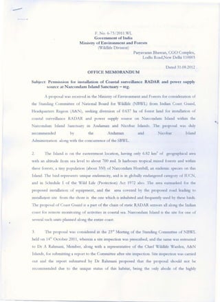
1. -
F. No. 6-73!2011.X/L
Government of India
Minis try of Environment and Forests
(WiJdl.J fe Division)
Paryavaran Bhawan, eGO Complex,
Lodhl Road,New DeUu 110003
Dated 31.08.2012
OFFICE MEMORANDUM
Subject: P ermission for installation of Coastal surveillance RADAR and power supply
so urce at Narcondamlsland Sanctuary - reg.
A proposal was rccelvcd ill the Mllustry o f Envuonment and Forests for conSlderatlon of
the Stancllng Com nuttce of Naaonal Board for WlldlLfe (NBWL) from Inman Coast Guard,
Headquarters Region (A&N), seelung diversion of 0.637 ha of fore st land for mstallatton of
coastal swvwlance RA D AR and power supply source on Narcondam Island wltbm the
Narcondam Island Sanctuary 10 Andaman and Nlcobar Islands . The proposal was duly
recommended by the A ndaman and Nlcobar Island
AdnuOlstraoon along With the concuuence o f the SBWL.
2. The Island IS o n the easternmost location, havmg only 6.82 km 2 of geograplucal area
With an altitude from sea level to about 700 msl. It harbours trOpICal mixed forests and warun
these forests, a ony populaaon (about 350) o f Narcondam Hornbill, an endctnlc species on tlus
Island. The bu:d represents umque endenuclty, and is In globally endangered category of IUCN,
and U1 Schedule I o f the W ild Life (protection) Act 1972 also. The area earmarked fo r the
proposed Illstallation of eqUIpment, and the area covered by the proposed road leading to
IOstaUaaon site from the shore IS the one wluch IS inhabited and &equendy used by these bltds.
The pro posa l of Coast G uard IS a pan o f the cham of static RADAR sensors all along the Inilian
coast for remote llloOltonng o f activities in coastal sea. Na rconda m Island IS dle site for one of
several such UOltS planned along the entu·e coast.
3. The proposal was considered 10 the 23";1 Meeung of the Standmg Commitree of NBWL
held on 14th October 2011, whercm a site inspection was prescribed, and dle same was entrusted
to Dr A Rahmal11, Member, along With a representatlve o f the Cillef WLldltfe Warden, A&N
Islands, for subnuttmg a report t.o the Committee after site mspection. SIte l1lspectlon was carned
oul and the report subrrutted by Dr Rahmaru proposed that the proposal should not be
recommended due to the uruque starus of th.is habitat, bemg the o nly abode of dle lughly
I ....
2. endemic speclcs of Narcondam Hombill. The report was considered In the 25'h Meeting of the
StancLng Committee held on 13 th June 2012.
4. Subsequently, several representations were received In the Mimstry related to the
conservatlOll value of tlle Island and the unique Narcondam Hornbill also. It is understood that
the majority of the nests of the small population of thIS speCIes (less than 350 buds) are located_at
about 200 meter hetght, wruch IS generally the same area in the Island, wluch is to be used by the
project for mstallauon of RADAR. For the duration of egg-bymg and duck-reanng, tlle females
shed the flight feathers and atc incapable of fught. fn the cucumstances, even If the area to be
. used fot the project IS less than 0.7 hectares, disturbances and damage caused to the habitat due
to ClltUOg of road through the area, and because of the regular functlorung of RADAR system, IS
likely to cause IIreversible advt;rse unpact on thiS ul1Ique bird, and can even wipe out the whole
populauon o f tills bud, willch IS less than 350.
•
5. As far as the project of coastal surveillance RADAR of the Coas t Guard IS concerned, an
alternatlve analysIs 111 terms of choice of technology and other opoons for locatUlg the
surveillance system have not been elaborated in the proposal. iv1..mIStry IS of the view that the
other opuons for the purpose, lIke IIlstallauon of off-shore stmctures and several other viable
opuons ate available, which can spare tlle ul11que habitat of Narcondam lsland from disturbance.
Howcvcr, there IS no such option available for the Hornbill whose survtval may get setJously
threatened If tlle establishment of proposed R.A DAR IS allowed on tlle Narcondam Island.
6. In view of the aforesaid, the proposal for diversion of 0.637 ha of forest land fO[
lllstalla uon of Coastal Surveillance RADAR and power supply source at Narcondam Island
SanctualY can not be reconllnended. The proponents afe adVised to consU(ute a commlltce of
experts to study and explore ot.her aJternauves lIke aenal, s:1tellite, o ff shore, ship -based or land-
based surveillance systems at other islands, for ensunng the clcft'Tlce and economic secutlty of the
country. The experts m:1y reprcsel1l the disciphnes of:-
(1) Secun ty and sea water surveillance (pOSSibly DRDO)
(ll) Islands and marllle ecology
(ill) Manne structural engmcenng
(iv) Coasl Guards
3. --
.,. This Issues WIth the approval of the 1 hnlstcr of State (Indepen dent Charge) EnVLfonmcnt
and Forests, and the Chairperson of the Sta ndmg Committee for NBVL.
L,,~ ~'0L
(VQ~ Saxena)
Deputy Inspector General of Forests (VL)
1. ChlefSecrerary,Andaman and Nicobar 1 ~ l a nd s, Port Blalr
2. Pnnclpal Secretary Fo res ts a nd P CC F, Andaman and NlCobar Islands, Port Blall·
3, Prmclpal Secretary (X1 L) and Chief WLldlife Warden, A ndaman and N lcobar Islands, POrt
Blalt
~: Technlc,1 D~ecto" (N IC) fa< uplo,dmg the O.M. o n the MUll"')," webs"e.
•
I