MYSTIC SYMBOL
•Download as DOC, PDF•
4 likes•8,833 views

THE MYSTIC SYMBOL (Mark of the Michigan Mound Builders) Dr. R.M. de Jonge ©, drsrmdejonge@hotmail.com

Recommended
More Related Content
What's hot
What's hot (20)
Similar to MYSTIC SYMBOL
Similar to MYSTIC SYMBOL (20)
More from INSTITUTE OF MEGALITHIC RESEARCH
More from INSTITUTE OF MEGALITHIC RESEARCH (20)
Recently uploaded
Recently uploaded (20)
MYSTIC SYMBOL
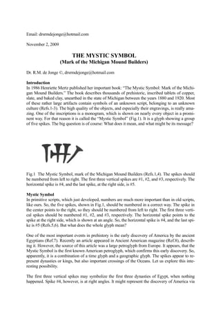
- 1. Email: drsrmdejonge@hotmail.com November 2, 2009 THE MYSTIC SYMBOL (Mark of the Michigan Mound Builders) Dr. R.M. de Jonge ©, drsrmdejonge@hotmail.com Introduction In 1986 Henriette Mertz published her important book: “The Mystic Symbol: Mark of the Michi- gan Mound Builders.” The book describes thousands of prehistoric, inscribed tablets of copper, slate, and baked clay, unearthed in the state of Michigan between the years 1880 and 1920. Most of these rather large artifacts contain symbols of an unknown script, belonging to an unknown culture (Refs.1-3). The high quality of the objects, and especially their engravings, is really ama- zing. One of the inscriptions is a monogram, which is shown on nearly every object in a promi- nent way. For that reason it is called the “Mystic Symbol” (Fig.1). It is a glyph showing a group of five spikes. The big question is of course: What does it mean, and what might be its message? Fig.1 The Mystic Symbol, mark of the Michigan Mound Builders (Refs.1,4). The spikes should be numbered from left to right. The first three vertical spikes are #1, #2, and #3, respectively. The horizontal spike is #4, and the last spike, at the right side, is #5. Mystic Symbol In primitive scripts, which just developed, numbers are much more important than in old scripts, like ours. So, the five spikes, shown in Fig.1, should be numbered in a correct way. The spike in the center points to the right, so they should be numbered from left to right. The first three verti- cal spikes should be numbered #1, #2, and #3, respectively. The horizontal spike points to the spike at the right side, which is shown at an angle. So, the horizontal spike is #4, and the last spi- ke is #5 (Refs.5,6). But what does the whole glyph mean? One of the most important events in prehistory is the early discovery of America by the ancient Egyptians (Ref.7). Recently an article appeared in Ancient American magazine (Ref.8), describ- ing it. However, the source of this article was a large petroglyph from Europe. It appears, that the Mystic Symbol is the first known American petroglyph, which confirms this early discovery. So, apparently, it is a combination of a time glyph and a geographic glyph. The spikes appear to re- present dynasties or kings, but also important crossings of the Oceans. Let us explore this inte- resting possibility. The first three vertical spikes may symbolize the first three dynasties of Egypt, when nothing happened. Spike #4, however, is at right angles. It might represent the discovery of America via
- 2. the southern Aleutian Islands (spike #2), and slightly later via the Bering Strait (spike #3), in the Fourth Dynasty (spike #4, c.2570 BC). So, the surface area of the center of the glyph seems to represent the Bering Sea, with left of it the northern Pacific. Special spike #5, at the right side, may represent the 5th king Menkaure (Mycerinos), who is credited for these discoveries (Ref.8). In antiquity, the Sumerian civilization in Mesopotamia was the eastern civilization, which used these spikes in their cuneiform script. So, the Egyptian discovery of America happened via the mouth of the Euphrates-Tigris river system. The sequence of numbering the spikes, from left to right, is in agreement with this discovery, from west to east. However, the wide tops of the spikes may also represent the East Coast of America, which was reached in the Fifth Dynasty (special spike #5). So, now the surface area of the glyph represents the North Atlantic Ocean, viewed from east to west. The first spike, at the left side, symbolizes the Southern Crossing from Africa to Brazil (#1), and the second spike represents the Return Route from Newfoundland to the Azores (#2), both with the wind and the current (Refs.9,10). These two vertical spikes symbolize the discovery of these two Crossings (c.2505 BC), each with a sailing distance of 2 Egyptian Moiras, or 20°, by the 2nd king Sahura (spike #2). The two free standing spikes, #5 and #1, strongly confirm it. The third spike (#3) represents the Northern Crossing, from the Shetland Islands, via the south point of Greenland, to Cape Chidley, Canada (Refs.11-13). The crossing via these three land- points happened at the complementary latitude of the Nile Delta, at 90-30= 60°N. This third crossing (spike #3) was discovered (c.2490 BC) by the 3rd king Nefererkare (spike #3). The cen- tral group of three joined spikes strongly confirms it. This group, and the three vertical spikes, both confirm, that the three kings, mentioned so far, were descended from the Nile Delta of Egypt, at 30°N. The horizontal spike #4 suggests that there is a fourth Crossing of the Atlantic, which is correct. It is the Return Route from Abaco Island, via Bermuda, to the Azores, with the wind and the cur- rent (Refs.8-13). The central part of the glyph contains 3+2x2= 7 small pieces of line. Together with the outer spikes, #1 and #5, these form together 7+2= 9 pieces of line, confirming the island of Bermuda, 9° above the Tropic of Cancer, at 23+9= 32°N. The Tropic of Cancer is a holy line in the Sun religion (Refs.7,16). The 9 lines celebrate the discovery of the Return Route via Ber- muda to the 9 islands of the Azores (c.2385 BC), by the 9th, and last, king Unas. The special spi- ke #5 indicates it was a king of the Fifth Dynasty (Ref.8).
- 3. Fig.2 Michigan slate tablet from the Soper-Salvage collection (Ref.4). The Mystic Symbol is shown in the center of the lowest row. The script contains many Egyptian hieroglyphs (2500-1400 BC). Message The Mystic Symbol describes the Egyptian discovery of America during the Old Kingdom. We understand its meaning, but what might be its message? Well, this might be complicated, too. It appears, that originally, Michigan was a full colony of Egypt. The people recognized the Egyp- tian king as their own leader, and, apparently, they adopted the Egyptian Sun religion as their faith. It means, that they did not feel any affection with the time period before this discovery, nor with any possible (important) development after it. It was the basis of their culture, and their script must be strongly related to Egyptian hieroglyphics (which is confirmed, indeed; see Fig.2). Archaeologists call this people “Mound Builders”, and it should be realized, that the Mound was the earliest form of a king’s grave.
- 4. The Mystic Symbol has two vertical spikes in the center, which are joined. It might correspond with the latitude-line at 20°N. Together with the other three spikes it encodes the holy Tropic of Cancer, at 20+3= 23°N. At midsummer day the Sun is there at right angles above. The slow nor- therly movement of the Sun turns into a southerly movement. So, one believes in the Egyptian SunGod Ra. It also corresponds with the place where the Tropic of Cancer crosses the River Ni- le. It is the center of the Sun religion, as well as the Southern Egyptian Empire (Refs.7,14). The first three vertical spikes correspond with the Nile Delta, at 30°N, the center of the Northern Egyptian Empire, but it also encodes the Mississippi Delta, of course. It is located almost due south of Michigan. However, there is more. The Mystic Symbol appears to show the borders of their Country. The horizontal spike #4 corresponded with the 4th Dynasty. It also encodes the southern border at the latitude-line of 40°N, at the level of the present city of Indianapolis. The last spike #5 corres- ponded with the 5th king. It also encodes the northern border of the Country at the latitude-line of 50°N, halfway between Lake Superior and James Bay. The center of the glyph consists of spikes #2, #3, and #4. These may correspond to degrees of latitude above 40°N. It probably means, that the heartland of ancient Michigan was located around the latitudes of 42°N, 43°N, and 44°N. Horizontal spike #4 points to last spike #5. It corresponded with the 5th king of the 4th Dynasty of Egypt. It means that the latitude of 45°N was important in a religious sense. Monuments and petroglyphs related to this culture might exist around this special latitude (Ref.7). So, in ancient Michigan the magical latitude-line at 45°N, halfway their own Country, and half- way between the equator and the North Pole, appears to be important. The Mystic Symbol now provides valuable information about the northern half of their territory. The vertical spikes #2 and #3 in the center, which are joined, encode the copper mines of Keweenaw Peninsula, at 45+2= 47°N, and Isle Royale, at 45+3= 48°N, respectively. Below the horizontal spike is a square between these lines, resembling a copper ingot. All spikes are even fabricated of copper! So, the Mystic Symbol appears to show, that Michigan was the heartland of the ancient Copper Culture. The square, with its four sides, also confirms the discovery of America in the 4th Dy- nasty. It was the start of the copper trade (Refs.14-16)! The three vertical spikes indicate, that 3/5 (or 60%) of the ingots were shipped to the south, to the Mississippi Delta, at 30°N. The other two spikes show, that 2/5 (or 40%) of the ingots were transported to the east, to the mouth of the Saint Lawrence River, at 30+20= 50°N (Refs.6,17-21). Tin Trade: The Untold Story Horizontal spike #4 describes the discovery of America in the 4th Dynasty (see above). It hits two other spikes, #2 and #3, also symbolizing the discovery of two continents, North America and South America. The areas between both spikes represent their approximate surface area and shape. This discovery happened in the Bronze Age. Spike #2 represents Keweenaw Peninsula, at 47°N (see above). It is located 17° above the Mis- sissippi Delta, at 30°N, and it might be considered as the center of copper mining. However, in antiquity bronze was made by alloying the copper with 10% tin. So, tin mining was also impor- tant. When spike #2 represents the copper, spike #3 might represent the tin (and spike #4 may symbolize the bronze). So, spike #3 might also represent the present town of Oruro, Bolivia, 18° below the equator, at 18°S (see above). It might be considered as the center of tin mining of the Andes civilization (Refs.17-20).
- 5. The tin ingots were transported along the coast to the north, and from the Pacific to the Atlantic. The whole glyph contains 9 pieces of line (see above). So, these were carried across the isthmus of Panama, at 9°N. The spikes in the center consist of 7 pieces of line. So, the ingots were ship- ped to the culture along the north coast of Honduras, at 9+7= 16°N. The two outer spikes show the tin was even brought to the center of civilization around the south point of the Gulf of Cam- peche, at 16+2= 18°N. This is the famous Land of Punt (Refs.7,16). It is represented by spike #4, which symbolizes the bronze (see above). The Mystic Symbol is the mark of the Michigan Mound Builders. The five copper nails symbo- lized their yearly copper production, which was hugh. Note, that spike #4, representing the 4th Dynasty, cuts spike #3 in half. The lower half of this nail represents the yearly tin production from South America. Spike #5 points to this part, confirming the five nails just mentioned. So, right from the start the tin export from Bolivia was 1/10, or 10%, of the copper production from North America (Refs.17-20). Date Sometimes, the Mystic Symbol is shown on artifacts without other written messages (Refs.4,22-24). However, in general this is not the case. It is surprising though, that the other messages are never written in the same type of cuneiform script, resembling that of the Sumerian civilization. However, the Symbol occurs on objects covered with different types of script, as illustrated be-low (Refs.25,26). Fig.2 was an example, where the Symbol is accompanied by a script contai-ning many Egyptian hieroglyphs, in the upper part even in vertical columns. This tablet may be very old. It contains at least one image of a chicken. Berry Fell notes (Ref.25): “Use of the spiral sign in place of the chicken … points to a date later than about 1400 BC, ….” The Mystic Sym-bol itself refers to the discovery of America, c.2500 BC. So, this tablet may date between 2500 and 1400 BC. Fig.3 is an example, which contains some traditional Egyptian hieroglyphs, but to a much lesser extend. It contains many other signs of a different type, not ocurring in the previous figure. Fig.2 showed people from the side, in the typical ancient, Egyptian way. However, the tablet of Fig.3 shows three frontal faces. So, this last tablet appears to be of later date.- Figs.4 and 5 contain different scripts, but hardly any Egyptian symbols at all. Our conclusion is these date from a later time period.- Fig.6 even shows Christian symbolism, and, again, it contains a new script. Its date is undoubtedly (much) later. So, our conclusion is that the Mystic Symbol was used during a long period of time. Artifacts containing this Symbol may date from 2500 BC to about 1000 AD. Discussion The primary meaning of the Mystic Symbol deals with the Egyptian discovery of America, c. 2500 BC. It is well-known, that the intercontinental, copper trade started at the very same date. The Copper Culture flourished till the end of the 19th Dynasty, c.1200 BC, which is a time period of thirteen centuries (1,300 years). The Mystic Symbol is the mark of the Michigan Mound Builders, because the ancient Copper Culture was the basis of their identity. During this time period America was a colony of Egypt, and the people in North America accepted the Egyptian kings as their leader. The Mound is the earliest form of a king’s grave. It appears, that the people of Michigan continued to honour their kings also after c.1200 BC. They probably did so well into the first millennium of the Christian Era, maybe even beyond. References 1. Mertz, H., The Mystic Symbol: Mark of the Michigan Mound Builders, Global Books, Gaith- ersburg, MD (1986).
- 6. 2. Etzenhouser, R., Engravings of Prehistoric Specimens from Michigan, USA, John Bornman & Sons, Detroit, MI, 1910, reprinted by ISAC Press, Columbus, GA, 1993. 3. Deal, D.A., “The Mystic Symbol De-mystified”, Ancient American, Vol.1, No.5, pgs.16-23 (1994); Midwestern Epigraphic Soc., 16 (2), 24-32 (2002). 4. Deal, D.A., “Michigan Artifacts Fakes or History, Ancient American”, Vol.9, No.55, pgs.23-29. 5. De Jonge, R.M., Website: www.slideshare.net/rmdejonge/ 6. De Jonge, R.M., “Wheeler’s Petroglyph (Copper Country, Michigan, 2500-1200 BC)”, Ref.5, to be published. 7. De Jonge, R.M., and Wakefield, J.S., How the Sungod Reached America, c.2500 BC, A Guide to Megalithic Sites, MCS Inc., 2002 (ISBN 0-917054-19-9). Available: MCS Inc., Box 3392, Kirkland, Wa 98083-3392, also on CD. Website: www.howthesungod.com. 8. De Jonge, R.M., “The Discovery of Three Continents (Santo Stefano, North Sardinia, Italy, c.2300 BC)”, Ancient American, Vol.12, No.76, pgs.28-29 (2007), Ref.5. 9. Casson, L., Ships and Seafaring in Ancient Times, British Museum Press, 1994 (ISBN 0-7141-1735-8). 10. Wachsmann, S., Seagoing Ships and Seamanship in the Bronze Age Levant, College Station, Texas, 1998. 11. De Jonge, R.M., and Wakefield, J.S., “The Discovery of the Atlantic Islands”, Ancient American, Vol.13, No.81, pgs.18-25 (2008). 12. De Jonge, R.M., and Wakefield, J.S., “Greenland, Bridge between the Old and New World, c.2500 BC”, Ancient American, Vol.11, No.67, pgs.12-20 (2006). 13. De Jonge, R.M., and Wakefield, J.S., “A Nautical Center for Crossing the Ocean, America’s Stonehenge, New Hampshire, c.2200 BC”, Migration & Diffusion, Vol.4, No.15, pgs.60-100 (2003). 14. Drier, R.W., and Du Temple, O.J., Prehistoric Copper Mining in the Lake Superior Region, A Collection of Reference Articles, published privately, 1961, and reprinted in 2005. 15. Rydholm, C.F., Michigan Copper, The Untold Story, Winter Cabin Books, Marquette, 2006 (ISBN 0-9744679-2-8). 16. Wakefield, J.S., and De Jonge, R.M., Rocks & Rows, Sailing Routes across the Atlantic and the Copper Trade, MCS Inc, 2010 (ISBN 0-917054-20-2). Available: MCS Inc, Box 3392, Kirkland, Wa USA 98033. 17. De Jonge, R.M., “Petroglyph of a Sailing Boat (Copper Harbor, Upper Michigan, c.1640 BC)”, Ref.5, to be published. 18. De Jonge, R.M., The Phaistos Disc Decoded, New Testimony of a Lost Civilization, Mid- western Epigraphic Journal, Vol.20, 111-115 (2006), and Vol.21, 74-80 (2007), to be published 19. De Jonge, R.M., “Copper Trade with the Old World (Poverty Point, NE Louisiana)”, Ref.5, to be published. 20. De Jonge, R.M., “The Battersea Shield (River Thames, London, c.190 BC)”, Ref.5, to be published. 21. De Jonge, R.M., and Wakefield, J.S., “The Embden Dragon Petroglyph, A Copper Trading Route of the Bronze Age (Kennebec River, Embden, Maine, c.1500 BC)”, Midwestern Epigra- phic Journal, Vol.18/9, pgs. 56-82, 2004-5 (ISSN 1932-5703). 22. White, J.J., and Moseley, B.H., “A Mystic Symbol Ship Artifact from Burrows Cave”, An- cient American, Vol.13, No.81, pg.4. 23. Hunter, M.R., “Michigan’s Forgotten Mound Builders”, Ancient American, Vol.13, No.82, pgs.2,3,10-14. 24. White, J.J., “Discussion of the Mystic Symbol Colonies”, Midwestern Epigraphic Journal, Vol.21, pgs.58-61 (2007).
- 7. 25. Merz, H., “The Lost Gods and Tablet of Prehistoric Michigan”, Ancient American, Vol.11, No.71, pgs.18,19. 26. Deal, D.A., Necrology, Ancient American, Vol.13, No.82, pg.4. Fig.3 Michigan slate tablet (Ref.4). The Mystic Symbol is shown seven times. The script contains less Egyptian hieroglyphs (2500-1400 BC).
- 8. Fig.4 Michigan slate tablet (Ref.23). The Mystic Symbol is shown three times. The script con- tains hardly any Egyptian hieroglyphs (1200-400 BC).
- 9. Fig.5 Michigan baked clay artifact (Ref.23). The Mystic Symbol is shown once. The script is completely different from the others (1200 BC-100 AD). Fig.6 Inscribed stone from Burrows Cave, southern Illinois (Ref.24, drawing by B.H. Moseley). The Mystic Symbol is shown once. Again, the script is completely different, and the illustration shows Christian symbolism (100 BC-1000 AD).