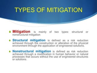
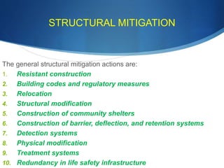
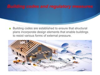
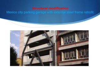
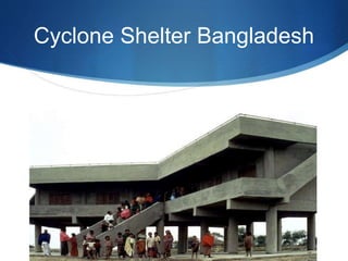
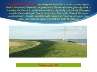
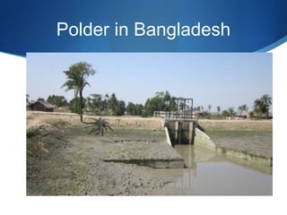
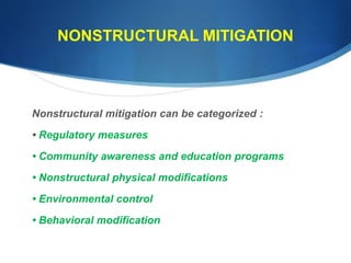
The document discusses modern disaster management approaches and focuses on mitigation and disaster risk reduction. It describes the four phases of disaster management as mitigation, preparedness, response, and recovery. Mitigation, also called disaster risk reduction, aims to reduce the impacts of hazards before they occur through both structural measures like building codes and non-structural measures like education programs. The document then provides details on different types of mitigation strategies used in Bangladesh to reduce risks from floods and cyclones, including embankments, cyclone shelters, and coastal afforestation. It also discusses challenges with solely relying on structural measures and the importance of combining both structural and non-structural approaches.
2. MODERN DISASTER MANAGEMENT – A FOUR-PHASE
APPROACH
Comprehensive disaster management is based upon four distinct components:
mitigation, preparedness, response, and recovery.
1. Mitigation. Also called Disaster Risk Reduction (DRR), mitigation involves reducing or
eliminating the likelihood or the consequences of a hazard, or both.
2. Preparedness. This involves equipping people who may be impacted by a disaster or who
may be able to help those impacted with the tools to increase their chances of survival and to
minimize their financial and other losses.
3. Response. This involves taking action to reduce or eliminate the impact of disasters that
have occurred or are currently occurring, in order to prevent further suffering, financial loss, or
a combination of both.
4. Recovery. This involves returning victims’ lives back to a normal state following the impact of
disaster consequences.
3. WHAT IS MITIGATION?
S Mitigation, also called Prevention or Disaster risk reduction, is considered the
“Cornerstone of disaster management”
S Mitigation includes any action or sustained effort undertaken to reduce a hazard
risk through the reduction of the likelihood and/or the consequence component of
that hazard’s risk.
S In other words, mitigation seeks to either make a hazard less
likely to occur or reduce the negative effects if it were to
occur.
S Unlike other components of disaster risk management , mitigation measures seek to
reduce the likelihood or consequences of hazard risk before a disaster ever occurs.
4. TYPES OF MITIGATION
S Mitigation is mainly of two types: structural or
nonstructural mitigation
S Structural mitigation is defined as a risk reduction
achieved through the construction or alteration of the physical
environment through the application of engineered solutions.
S Nonstructural mitigation is defined as risk reduction
achieved through a modification in human behavior or natural
processes that occurs without the use of engineered structures
or solutions.
5. STRUCTURAL MITIGATION
The general structural mitigation actions are:
1. Resistant construction
2. Building codes and regulatory measures
3. Relocation
4. Structural modification
5. Construction of community shelters
6. Construction of barrier, deflection, and retention systems
7. Detection systems
8. Physical modification
9. Treatment systems
10. Redundancy in life safety infrastructure
6. The best way to maximize a structure’s ability to resist a
hazard’s forces is to ensure that its design and materials are
selected with these threats in mind prior to construction
Resistance construction :House Built above flood level, Ecuador
7. Building codes and regulatory measures
S Building codes are established to ensure that structural
plans incorporate design elements that enable buildings
to resist various forms of external pressure.
8. Relocation
S After building of Aswan Dam in Nile , Abu Simbel Temple
of Egypt was relocated 90 miters from the original place
for preserving historical heritage.
11. Barriers are designed to stop a physical force dead in its tracks. Their job
is to absorb the impact of whatever force is being exerted.( for example,
Seawalls (cyclonic storm surges, tsunamis, high waves, rough seas, and
coastal erosion; Floodwalls, dikes, berms (floods, flash floods; Mass
movement protection walls (landslides, mudslides, rockslides, avalanches)
Sea Wal
12. Deflection systems are designed to divert the physical force of a hazard,
allowing it to change course so that a structure situated in its original path escapes
harm. Avalanche bridges (snow avalanches) Chutes (landslides, mudflows, lahars,
rockslides) Lava flow channels (volcanic lava)
Lava channel
13. Retention systems are designed to contain a hazard, preventing its
destructive forces from ever being released. These structures generally seek to
increase the threshold to which hazards are physically maintained. Examples
include: Dams (drought, floods) Levees and flood walls (floods) Slit dams
(sedimentation, floods) Landslide walls made from masonry, concrete, rock
cage, crib walls, bin walls, and buttress walls landslides)
Embankment, UK
16. NONSTRUCTURAL MITIGATION
Nonstructural mitigation can be categorized :
• Regulatory measures
• Community awareness and education programs
• Nonstructural physical modifications
• Environmental control
• Behavioral modification
17. Regulatory Measures
Regulatory measures limit hazard risk by legally dictating human actions. Regulations can
be applied to several facets of societal and individual life, and are used when it is determined
that such action is required for the common good of the society.
Examples of regulatory mitigation measures include:
S Land use management (zoning).
S Open space preservation (green spaces).
S Protective resource preservation
S Denial of services to high-risk areas.
S Density control
S Safety standards and regulations
S Environmental protection regulations.
18. Community Awareness and
Education Programs
S Public education programs are considered both mitigation
and preparedness measures.
S An informed public that applies appropriate measures to
reduce their risk before a disaster occurs has performed
mitigation.
S Warning systems inform the public that a hazard risk has
reached a threshold requiring certain protective actions.
20. Environmental Control
These nonstructural mechanisms tend to be highly hazard specific, and
include:
• Explosive detonation to relieve seismic pressure (earthquakes)
• Launched or placed explosives to release stored snow cover (avalanches)
• Cloud seeding (hail, hurricanes, drought, snow)
• Chemical surface treatment (ice and snowstorms)
• Controlled burns (wildfires)
• Bombing of volcano flows (volcanic eruption)
• Dune and beach restoration or preservation (storm surges, tsunamis, erosion)
• Forest and vegetation management (landslides, mudflows, flooding, erosion)
• Riverine and reservoir sediment and erosion control (flooding)
21. Behavioral Modification
S Through collective action, a community can alter the behavior
of individuals, resulting in some common risk reduction benefit.
Examples of mitigation measures:
S Rationing
S Environmental conservation.
S Tax incentives, subsidies, and other financial rewards for safe
practices
S Strengthening of social ties.
22. OBSTACLES TO MITIGATION
S The first and primary obstacle is cost. Mitigation projects can be very expensive. Although
governments often have the resources to carry out even very costly mitigation projects, they may
instead choose to fund non-disaster programs perceived to be more pressing.
S The second obstacle is low levels of political support or “buy-in.” It is important for political
leaders to maintain a positive image among constituents.
S The third obstacle is a lack of capacity. Disaster risk reduction efforts require technical expertise
as well as an ability to gather or formulate risk information.
S Sociocultural issues are a fourth potential obstacle. Mitigation measures almost always result in
a change of some sort, whether to a place (location), a practice, or a physical structure. People and
cultures may tie meaning to these factors and resist any project that involves an alteration they find
undesirable.
S Risk perception can present another major obstacle to mitigation.
24. Disaster Risk Reduction(DRR):We need to
manage risks, not just disasters!
S Disaster risk reduction is the concept and practice of reducing disaster risks
through systematic efforts to analyze and reduce the causal factors of
disasters.
S Reducing exposure to hazards, lessening vulnerability of people and
property, wise management of land and the environment, and improving
preparedness for adverse events are all examples of disaster risk reduction.
S Historically, dealing with disasters focused on emergency response, but
towards the end of the 20th century it was increasingly recognized that
disasters are not natural (even if the associated hazard is) and that it is only
by reducing and managing conditions of hazard, exposure and vulnerability
that we can prevent losses and alleviate the impacts of disasters.
25. Disaster risk reduction is everyone's business.
S Disaster risk reduction includes disciplines like disaster
management, disaster mitigation and disaster preparedness, but
DRR is also part of sustainable development.
S The goal of DRR is to reduce vulnerabilities and disaster risks
through prevention , mitigation, and preparedness
S In order for development activities to be sustainable they must also
reduce disaster risk. On the other hand, unsound development
policies will increase disaster risk - and disaster losses. Thus, DRR
involves every part of society, every part of government, and every
part of the professional and private sector.
27. DRR Measures taken by Government of Bangladesh
(GOB)
S GOB has given equal importance to both structural as well as non-structural
mitigation measures
S As part of structural measures, the GOB with its own and external resources has so
far constructed 1,841 cyclone shelters and 200 flood shelters for evacuation of
people exposed to impending cyclone as well as floods.
S In addition, during the last four decades 482 small, medium and large water and
flood control projects have been implemented. Of these, more than 400 projects
were implemented after the war of liberation in 1971.
S Through these projects, about 8,200 km long flood protection embankment,
drainage channels of 3,400 km total length and 9,000 sluice gates and regulators on
different rivers and canals as safety measures against inundation by tidal waves,
storm-surges and flooding have been constructed.
28. FLOOD RISK REDUCTION MEASURES
S Due to high vulnerability to floods, flood management in Bangladesh
is considered to be crucial to poverty reduction initiatives in the
country
S The Flood Action Plan (FAP) came into action following major
floods in 1987 and 1988 with a long-term focus on sustainable
solution to flooding problem in Bangladesh.
S The main objectives of the FAP are to: safeguard lives and
livelihoods, minimize potential flood damage, improve agro-
ecological conditions for enhanced crop production, meet the
needs of fisheries, navigation, communications and public
health, promote commerce and industry, and create flood-free
29. Structural and Nonstructural flood control Measures
Flood control measures in Bangladesh are mainly limited to building of
earthen embankments, polders, and drainage.
Strategies adapted by both public and individuals can be anyway
classified into two groups as :
Measure which adjust damages from floods to people (structures
such as embankments);
Measures where people adjust to floods (“non-structural”
measures including flood proofing of buildings and settlements,
flood warnings, land use restrictions, and adjusting crop
calendars).
30. Dams and Embankments
S Since 1960s, Bangladesh government is involved in large scale
flood control projects and by 1993 over 8,000 km of embankments
and other structures had been built at a cost of over US$5 billion.
S Loop embankments or polders have been built to protect major
urban centers and coastal agricultural land while submersible
embankments have been constructed for crop production and
protection against flash floods in certain areas
S Bangladesh has 123 polders, of which 49 are sea-facing. These
were constructed in the 1960s to protect the coast from tidal
flooding and reduce salinity incursion .
31. Dams and Embankment can pose risk
S Although certain measures like embankments and polders have
been able to reduce floodplain storage capacity during floods,
leading to an increase in water levels and discharges in many
rivers, embankments tend to create a false sense of security
among residence living within embanked areas .
S For example, there are several reported incidences on
embankments breaching and erosion in Bangladesh such as
breaching of Gumti embankment at Etbarpur during 1999 flood
which caused substantial damage to the environment and
property .
S Moreover, earthen embankments can also be easily breach and
can be damaged by riverbank erosion These are evident of
ineffectiveness of embankments as flood controlling measures.
32. Ineffectiveness is the
challenge
S These are evident of ineffectiveness of embankments as flood controlling measures. On
top of that, adverse impact of construction of embankments is broadened to obstruction
of fish migration routes and spawning grounds, and deterioration of floodplain
ecosystem.
S Improving gravity drainage is another measure which adjusts flood extent to people.
This is done through excavation and re-excavation of canals and dredging of rivers
.Pumped drainage infrastructures have been constructed where gravity drainage is
inadequate .
S Although pumped drainage infrastructure in urban loop embankments has been effective
for mitigation of storm water flooding, it has not been cost-effective and resulted in
channel sedimentation and adverse environmental impacts in rural flood control projects .
S Further to that, encroachment of storm water retention areas, obstruction of drainage
routes and unplanned urban development usually weaken the effectiveness of pumped
drainage infrastructure in urban areas .
S Construction of storm sewer and pump station is another measure adapted by the Dhaka
Water Supply and Sewerage Authority to alleviate the internal drainage problems of
33. Flood forecasting and warning
S Non-structural measures were considered as a means for mitigating flood
damages. The Flood Forecasting and Warning Center (FFWC) of
Bangladesh Water Development Board (BWDB) established in 1972, is
responsible for making flood forecasts and flood warning during the flood
seasons.
S The monitoring of floods and issue of flood forecasts are carried out in
relation to Danger Levels (above which the flood is likely to cause
damage to crops and homesteads) specified for each river gauging
stations. The FFWC collects real-time data of water level (3 hourly)
from 55 observation stations and rainfall from 56 observation
stations. Currently a hydrodynamic mathematical model is used to
forecast water levels.
S At present, the FFWC issues river stages forecast for 50 stations in the
flood prone areas, formulated for lead time of 24 h and 48 h. The
forecasts in the form of daily water level bulletins are transmitted to
national radio, television, news agencies, newspapers, concerned
ministries and government offices and field wireless stations.
34. Rural People’s Strategy
S While Bangladesh government is mostly involved in taking actions to control floods, rural
people are mostly keen on putting in measures to adjust to floods.
S In USA, flood proofing measure are significantly implemented through building codes as
part of a set of floodplain management measures linked with floodplain zoning and
compulsory flood insurance .
S In Bangladesh, flood proofing measures include building homesteads on high grounds
above the flood level, modifications to existing flood prone houses (retrofitting) through
measure such as raising floors of homes , minor structural and non-structural measures,
public or community measures such as providing flood shelters, designing roads to be
above flood level, ensuring planning takes account of flood risks, and any measures to
reduce the economic vulnerability of households to flood losses .
S While traditional flood proofing measures such as raising of house floors and
adjustments to flooding are widely used in rural Bangladesh, there has been limited
official interest in flood proofing, except development of cyclone shelters in the coastal
regions, and a few flood shelters in or adjacent to the char areas i.e. active floodplains .
35. CYCLONE RISK REDUCTION MEASURES
S Engineering measures such as cyclone shelter is one of the key cyclone
mitigation measure adapted in Bangladesh. For effective employment and
management of cyclone shelters, multipurpose versions have been built in
carefully selected locations, identifying uses for both normal and disaster
periods.
S In 1972, the Bangladesh government began constructing public cyclone
shelters in coastal areas to help save lives of coastal residents from
cyclones and associated storm surges. These shelters are multi-storied
reinforced concrete buildings, raised above ground level (to resist
storm surges) and can accommodate 1500–2500 people.
S Coastal embankments are another mitigation measure implemented in
Bangladesh to reduce or prevent damage from cyclones and associated
storm surges. The height of these embankments ranges from 17 to 20 feet
(5–6 m) and they have marine and land-side slopes of 1:7 and 1:3,
36. Multipurpose Cyclone Shelter
S After an extensive study, the Multipurpose Cyclone Shelter
Program(MCSP) estimated the need of a total of 2,500 cyclone shelters in
the High Risk Area (HRA) along the coast considering the demand in the
year 2002 for a projected population of 4.7 million. Out of the 2,500
shelters, 60 % were proposed to be located in existing primary school
sites and the rest in new primary schools, madrasas and secondary
schools.
S At the time MCSP was being carried out, the Government of Bangladesh
had enacted a legislation to make attendance in primary schools compulsory
which required more than 3,000 primary schools to be constructed in the
HRA. This requirement of educational facilities matched very well with the
requirement of additional shelters (2,500) . Thus the “multipurpose” notion of
37. Coastal Afforestation
S Mangrove forests act as a shield against cyclone by lowering wind speed
as well as reducing the surge impacts; realizing this, coastal afforestation
with mangrove species was initiated along the Bangladesh coastal belt in
the 1960s.
S The benefit of coastal afforestation programs then extended to a number
of development agenda including protection of agricultural land against
salt intrusion, conservation of coastal ecosystem and environment,
protection of aquatic resources and wildlife and enhancing land
accretion, inter alia.
S Over the last four decades the Department of Forest has brought about
148,000 ha of land under mangrove plantations scattered over on- and
offshore areas mostly along the central part of the coast
38. DROUGHT RISK REDUCTION MEASURES
In the event of drought, the government of Bangladesh has undertaken irrigation project
through installing deep tube well to increase agricultural productivity particularly in the
northern region.
Records show that the irrigation coverage was less than 2 million ha in the early 1980s
and took almost two decades to reach about 5 million ha. It also reveals that the growth
rate was a bit higher in the last decade (starting from 1994) than the earlier decade
(starting from 1982).
Several governmental agencies like BMDA (Barind Multipurpose Development
Authority), BADC (Bangladesh Agricultural Development Corporation) and RDA
(Rural Development Academy) has undertaken irrigation project in drought affected
areas. Among them, BMDA plays the key role and has successfully expanded their
executing area through construction of cross dams and water control structures; re-
excavation of canals and ponds; installation of DTWs; afforestation; improve surface water
augmentation; construction of irrigation canals and roads; electric connection for the DTWs;
drinking water supply through the over head tank and production of fine and aromatic rice
etc.
Bangladesh has established institutions at the national level such as the Space Research
and Remote Sensing Organization (SPARRSO), the Bangladesh Meteorological
39. EARTHQUAKE RISK REDUCTION MEASURES
S Since in the last 100 years, there was no damaging earthquake in the country, the preparedness
and awareness level of the concerns are not within the scale of mapping.
S Considering the potential risks, the Government has taken initiatives through Comprehensive
Disaster Management Programme (CDMP) to assess the seismic risk following the deterministic
and probabilistic procedures mainly to address the scenario based earthquake risk management in
the country.
S Following the estimated scenarios, spatial emergency risk management plan in the name of
contingency plan developed for the main cities, viz., Dhaka. Chittagong and Sylhet as well as other
ten major responding agencies.
S Numbers of simulation exercises were conducted to implement the contingency plan. In order to
rightly address the earthquake risk reduction, government has taken number of initiatives onwards
2006 under the umbrella of CDMP.
S These are development of 62,000 Urban Community Volunteer mainly in the earthquake prone
cities, training for masons and bar binders as well as engineers, preparation of risk sensitive land
use planning, building awareness to the public representatives and city dwellers, increasing the
research activities in the government agencies and academic institutions as well as gradual
procurement of search and rescue equipments.
40. Food for Brain Storming ?!?
S What should be the goals of disaster mitigation in Bangladesh?
S What are the structural and nonstructural mitigation efforts in
case of Bangladesh?
S What are the obstacles of disaster mitigation in Bangladesh?