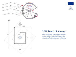
The F-35 Cockpit: Enabling the Pilot as a Tactical Decision Maker
Dr. Michael L. Skaff created this briefing. Skaff described his background in a recent interview as follows:
I was an F-16 pilot out of the Air Force Academy. I was prior enlisted, and I’ve been with Lockheed Martin for about 23 years working on the F-35 cockpit since ’95. I flew out of MacDill, Shaw, and Luke during the Cold War.
For a full discussion with Skaff regarding the baseline F-35 please see
http://www.sldinfo.com/understanding-the-basic-f-35-what-is-in-the-baseline-aircraft/
ADS-B: A pilot's guide to understanding the system and avionicsSporty's Pilot Shop
Join Sporty's John Zimmerman for a detailed look at Automatic Dependent Surveillance - Broadcast, the technology that's changing how pilots fly. From the basics of the system to portable ADS-B receivers to panel-mount ADS-B transmitters, you'll learn what ADS-B really means and how to fly with it.
Presented at the 2016 EAA AirVenture Oshkosh.
Cours sur le vol en VFR de nuit, réalisé dans le cadre de cours PPL(A).
Attention, ce support de formation peut contenir des erreurs éventuelles. Je vous recommande de vous rapprocher de votre FI attitré pour vos cours théoriques.
Certaines images et photographies sont issues de captures écrans depuis Google.
un indicador ambiental es un parámetro o valor derivado de parámetros que proporciona información para describir el estado de un fenómeno, ambiente o área, con un significado que va más allá del directamente asociado con el valor del parámetro en sí mismo.
Los Indicadores ambientales1 (no confundir con bioindicadores) son parámetros empleados para la evaluación del estado de un sistema ambiental complejo (como el clima, un paisaje o un ecosistema) que de otro modo resultarían difíciles de medir o evaluar. Los indicadores ambientales ayudan a seguir los avances en el logro de objetivos ambientales (por ejemplo, de los objetivos del desarrollo sostenible incluidos en los Objetivos del Milenio para el Desarrollo), su uso facilita la vigilancia y la toma de decisiones.
Según la Organización para la Cooperación y el Desarrollo Económico, la OCDE, un indicador es "un parámetro, o el valor resultante de un conjunto de parámetros, que ofrece información sobre un fenómeno, y que posee un significado más amplio que el estrictamente asociado a la configuración del parámetro".2
Support de cours pour la formation à la variante EFIS (Electronic Flight Instruments System) pour Glass Cockpit Garmin G1000.
Attention, ce support de formation peut contenir des erreurs éventuelles. Je vous recommande de vous rapprocher de votre FI attitré pour vos cours théoriques.
Certaines images et photographies sont issues de captures écrans depuis Google. Certains contenus sont issus de la documentation officielle de Garmin.
John Deere Tractors are one of the Best Farm Tractors in the World.
Their Tractors come in different size specifications.
www.tractoragriculture.com/john-deere-tractors/
Site: www.tractoragriculture.com/
Find the List of Best Farm Tractors in the World at Tractor Agriculture. We are single point destination for all your Tractor Research related tasks.
http://www.tractoragriculture.com/best-farm-tractors-in-the-world/
If you need to find particular information regarding a specific Tractor Brand, then you can get all the related information here.
http://www.tractoragriculture.com/
Operation and management of primary and secondary tillageagriyouthnepal
Er. Uttam Raj Timilsina(MSc.Engineering,IIT Roorkee)
Professor of Agricultural Engineering,Agriculture and Forestry University (AFU), Rampur, Chitwan, Nepal
uttamrajtimilsina@gmail.com
*All Right Reserved**
Uploaded and Shared by AgriYouthNepal
Term Paper Submitted in partial fulfillment of the requirements for the award of the degree of Bachelor of Technology In Aerospace Engineering.
AMITY UNIVERSITY DUBAI
The May/June 2014 issue of FAA Safety Briefing is all about Airworthiness Certification and Standards. In this issue we look at the hidden dangers of layering supplemental type certificates (STC), who to go to when your plane has an issue, and how to take care of an aging aircraft. In addition, you can learn more about the airworthiness directive process and how to apply for an STC.
According to the International Air Transport Association (IATA), some 3.6 billion passengers are expected to fly on commercial aircraft in 2016. That’s 800 million more than just five years ago. And these numbers continue to grow by more than five percent per year. We can build the airplanes but what about airports? The issue of expanding current airports and developing new ones is critical to the growth of the aviation industry.
We invite you to join us for “21st Century Airport Planning, Design, and Development,” a two-part webinar series presented by leading aviation experts from Embry-Riddle.
This is part--Part 1--Drs. Patti Clark and Katherine Moran will cover “Airport Sustainability, Safety, and Certification.”
This is a presentation by Dada Robert in a Your Skill Boost masterclass organised by the Excellence Foundation for South Sudan (EFSS) on Saturday, the 25th and Sunday, the 26th of May 2024.
He discussed the concept of quality improvement, emphasizing its applicability to various aspects of life, including personal, project, and program improvements. He defined quality as doing the right thing at the right time in the right way to achieve the best possible results and discussed the concept of the "gap" between what we know and what we do, and how this gap represents the areas we need to improve. He explained the scientific approach to quality improvement, which involves systematic performance analysis, testing and learning, and implementing change ideas. He also highlighted the importance of client focus and a team approach to quality improvement.
Read| The latest issue of The Challenger is here! We are thrilled to announce that our school paper has qualified for the NATIONAL SCHOOLS PRESS CONFERENCE (NSPC) 2024. Thank you for your unwavering support and trust. Dive into the stories that made us stand out!
How to Split Bills in the Odoo 17 POS ModuleCeline George
Bills have a main role in point of sale procedure. It will help to track sales, handling payments and giving receipts to customers. Bill splitting also has an important role in POS. For example, If some friends come together for dinner and if they want to divide the bill then it is possible by POS bill splitting. This slide will show how to split bills in odoo 17 POS.
How to Create Map Views in the Odoo 17 ERPCeline George
The map views are useful for providing a geographical representation of data. They allow users to visualize and analyze the data in a more intuitive manner.
Instructions for Submissions thorugh G- Classroom.pptxJheel Barad
This presentation provides a briefing on how to upload submissions and documents in Google Classroom. It was prepared as part of an orientation for new Sainik School in-service teacher trainees. As a training officer, my goal is to ensure that you are comfortable and proficient with this essential tool for managing assignments and fostering student engagement.
Ethnobotany and Ethnopharmacology:
Ethnobotany in herbal drug evaluation,
Impact of Ethnobotany in traditional medicine,
New development in herbals,
Bio-prospecting tools for drug discovery,
Role of Ethnopharmacology in drug evaluation,
Reverse Pharmacology.
Welcome to TechSoup New Member Orientation and Q&A (May 2024).pdfTechSoup
In this webinar you will learn how your organization can access TechSoup's wide variety of product discount and donation programs. From hardware to software, we'll give you a tour of the tools available to help your nonprofit with productivity, collaboration, financial management, donor tracking, security, and more.
1. Sugar Valley Comp Sq
Civil Air Patrol
Matthew T. Phillips, Maj, CAP
Professional Development Officer, MER-NC-082
Mission Pilot and SET-qualified Mission
Observer
Observer
Training
2. The SQTR Process
Every CAP Emergency Services qualification is awarded
following the completion of training objectives in a “Specialty
Qualification Training Record” (“SQTR,” pronounced ‘skeeter’)
Prerequisites
Familiarization and Preparatory Training
Advanced Training
Exercise Participation
The tasks involved at each level are tracked in “OpsQuals,”
which is available in eServices (http://www.capnhq.gov/).
Members frequently keep track of their training on paper
equivalents to the online system.
YOU own your training.
3. Prerequisites
General Emergency Services (Level 1 and CAPT 116)
Mission Scanner
Age Eligibility: 18 years
Commander Approval
Mission Observer
4. Familiarization and Preparatory Training
Use In-Flight Services (O-2010)
Plot a Route on a Sectional Chart (O-2013)
Prepare for a Trip to a Remote Mission Base (O-2107)
Discuss Mission Observer Duties and Responsibilities (P-2007)
Discuss the Dangers of Icing (P-2008)
Discuss the Dangers of Reduced Visibility Conditions (P-2009)
Discuss the Dangers of Wind and Thunderstorms (P-2010)
Discuss the Effects of Density Altitude on Aircraft Performance
(P-2011)
Identify Controlled and Special Use Airspace on a Sectional (P-
2012)
Mission Observer
5. Advanced Training
IS100 (FEMA Course; see http://bit.ly/capescourses)
IS700 (FEMA Course)
Aicraft Ground Handling
O-2002: Operate the Aircraft Radios
O-2011: Operate the VOR and DME
O-2012: Operate the GPS
O-2108: Assist in ELT Searches
O-2109: Assist in Planning and Performing a Route Search
O-2110: Assist in Planning and Performing a Parallel Search
O-2112: Assist in Planning and Performing Point Based Searches
O-2115: Assist in Planning and Performing a Creeping Line Search
Mission Observer
6. Observer Resources
National Emergency Services Academy / Mission Aircrew
School
http://nesa.cap.gov/mas-curriculum-2
Mission Aircrew Reference Text: Volume II – Mission
Pilot/Mission Observer
http://bit.ly/mo-reference
Operational Mission Inflight Guide
http://bit.ly/inflight-guide
Links updated 13 June 2014
7. Emergency Services Training and
Mission Participation
You need to be safe.
CAPF 161 (Emergency
contact information) with
copy for supervisor/mission
base.
Proper uniform.
Confidence and experience
in your assigned role.
You need to be qualified.
CAPF 101 with proper
qualifications shown.
New qualifications only from
qualified instructors.
9. Observer Duties and
Responsibilities
Report in “I’M SAFE” condition and ready
to conduct effective visual searches.
Appropriate uniform, gear, and
credentials.
Assist in planning; may be mission
commander.
Check necessary equipment on board
(especially checklists and references)
Assist in avoiding obstacles during
taxiing / airport operations.
Assist in radio operation.
Assist in navigation equipment operation
as directed.
Maintain situational awareness.
Assist in monitoring fuel status (and
other safety-of-flight issues).
10. Mission Planning
Plot a Route on a Sectional Chart (O-2013)
Prepare for a Trip to a Remote Mission Base (O-
2107)
Identify Controlled and Special Use Airspace on
a Sectional (P-2012)
11. Plot a Route on a Sectional Chart
Determine distance, heading, and approximate time to search
area.
Observe any obstacles, terrain issues, airspace classifications.
Observe search route issues (e.g. will standard search patterns
take you into controlled airspace?)
Note which visual cues you will use to aid the pilot in
navigating.
18. Prepare for Trip to Remote Base
Try to always have in a mission-ready bag:
Uniform (incl. change of t-shirts, etc.)
Credentials (PIC must certify to IC/FRO): FAA, Medical, CAPF 101,
CAPF 161, Driver License (state and CAP), SQTRs.
Planning supplies (sectionals, plotter, pens/pencils/highlighters,
extra paper, log forms, CAPF 104)
Personal equipment: headset, snacks, water, money
Cell phone (turned off in flight!)
Charts for mission areas
Road maps for mission areas
Back up the pilot: pre-flight inspections, weight-and-balance,
ORM analysis.
19. Weather and Hazards to Flight
Discuss the Dangers of Icing (P-2008)
Discuss the Dangers of Reduced Visibility Conditions (P-2009)
Discuss the Dangers of Wind and Thunderstorms (P-2010)
Discuss the Effects of Density Altitude on Aircraft Performance (P-2011)
Use In-Flight Services (O-2010)
20. Dangers of Icing
Types of Icing
Carburetor icing
Pitot icing
Airframe icing
Instrument effects
Incorrect readings
Airframe effects
Decreased lift
Increased drag
Decreased control effect
You could get cold.
21. Reduced Visibility and Turbulence
Reduced visibility makes it harder to see directly and indirectly.
Items outside the aircraft are obscured.
Looking into reduced visibility conditions tends to cause accelerated
eye fatigue.
Identifying hazards to flight is more difficult.
Turbulence is a disturbance in air patterns. Except in extreme
conditions, it is not unsafe…
UNLESS it makes aircrew uncomfortable or nauseous,
compromising effectiveness.
Do not try to be a hero.
Any adverse weather requires heightened vigilance by all
aircrew.
22. Dangers of Wind and
Thunderstorms
Control of aircraft, especially by crosswinds (particular danger
during takeoff and landing).
Compromised airspeed (rapid wind changes around the aircraft
can cause loss of control or stall).
Downdrafts can cause aircraft to lose altitude (see
development of thunderstorms on next slide).
25. Density Altitude
Atmospheric conditions (particularly temperature) can reduce
the airplane’s performance.
Airplane control performance is always reduced at higher
altitudes.
When it is particularly hot, the density altitude on the ground
may be several thousand feet more than the actual measured
elevation.
That means that on the ground, at 1000 feet MSL, the plane
will perform like it is at 3000 ft MSL, so it will climb slower, etc.
26. In-Flight Services
Flight Service Stations (also
called for briefing before flight).
Flight Watch (tune 122.0 and
call “Flight Watch”).
Automatic Terminal Information
Service (ATIS).
Hazardous In-Flight Weather
Advisory Service (HIWAS).
Pilot Reports (PIREP).
27. What to Expect from Inflight Training
Advanced training tasks are the practical information you’ll need to perform
as a Mission Observer.
28. CAP Search Patterns
Search patterns may seem complex,
but the goal is to simplify search to
increase effectiveness and efficiency.
30. Incident Command System
FEMA’s Incident Command
System ensures that
professionals and volunteers
from a wide range of training
backgrounds are able to work
together.
We frequently coordinate with
NC Emergency Management,
NC Highway Patrol, other CAP
wings, NC Air National Guard,
etc.
Mission Observer qualification
requires ICS-100 and ICS-700.