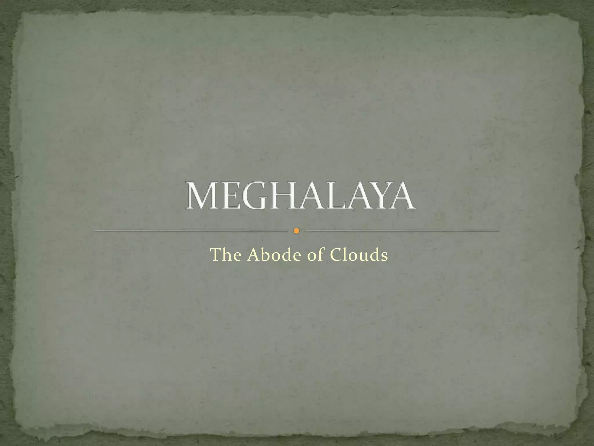
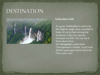
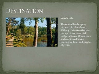
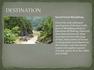
The Abode of Clouds
Meghalaya is a hilly state in northeastern India.
The name means "the abode of clouds" in Sanskrit.
Separating the Assam valley from the plains of
Bangladesh, hilly Meghalaya is a cool, pine-fresh
mountain state set on dramatic horseshoes of
rocky cliffs. Cherrapunjee and Mawsynram are
among the wettest places on Earth; most of the
rain falls between June and September, creating
very impressive waterfalls and carving out some of
Asia’s longest caves.
 The capital of Meghalaya is Shillong. During
the British rule of India, the British imperial
authorities nicknamed it the "Scotland of the East".
 Meghalaya was previously part of Assam, but on 21
January 1972, the districts of Khasi, Garo and Jaintia
hills became the new state of Meghalaya.
 Meghalaya has historically followed
a matrilineal system where the lineage and inheritance
are traced through women.
 English is the official language of Meghalaya.
Meghalaya currently has 11 districts.
Jaintia Hills
West Jaintia Hills (Jowai)
East Jaintia Hills (Khliehriat)
Khasi Hills Division
East Khasi Hills (Shillong)
West Khasi Hills (Nongstoin)
South West Khasi Hills (Mawkyrwat)
Ri-Bhoi (Nongpoh)
Garo Hills Division
North Garo Hills (Resubelpara)
East Garo Hills (Williamnagar)
South Garo Hills (Baghmara)
West Garo Hills (Tura)
South West Garo Hills (Ampati)
 TOURISM MINISTER: Shri. Metbah Lyngdoh
 Commissioner & Secretary, Tourism Department:
Dr. Vijay Kumar D, IAS
 Director of Tourism: Shri. C. V. D. Diengdoh, IAS
 Deputy Secretary, Tourism Department:
Smt. R C Sohkhlet, IAS
Nongriat Root Bridges
The most fascinating sights around
Cherrapunjee are the incredible
living bridges – formed from rubber-
fig roots that ingenious Khasi
villagers have, over decades, trained
across streams as natural pathways.
Over 40 of these are said to be
scattered around the Meghalaya hills
and several of them (including an
amazing ‘double-decker’) are near
the jungle valley hamlet
of Nongriat – a steep hike down
2600 steps (and up 500) from Tyrna
village, 12km southwest of
Cherrapunjee.
Nohkalikai Falls
At 340m, Nohkalikai is said to be
the highest single-drop waterfall in
India. It's at its best during the
monsoon, when its capacity
increases 20-fold. You can see it
from above from
the viewpoint 4.4km from
Cherrapunjee's market. Local taxis
shuttle passengers back and forth
(₹150 each way).
Balpakram National Park
Hilly Balpakram is traditionally
considered by the Garo to be
the ‘abode of souls’, where
people temporarily go after they
die, and is full of mythological
associations. The 220-sq-km
park is thick with wildflowers
and butterflies in spring, and
has some elephants and
Hoolock gibbons, but is chiefly
of interest to birdwatchers. A
jeep road runs about 12km to a
plateau, with some walking
trails leading off it. Get permits
from the forest office in
Baghmara, about 45km west.
Mawsmai Cave
This 150m-long limestone
cavern, with its low passages, is
the most impressive of the area's
easily accessible caves and very
popular with domestic tourists.
Mawsmai’s old monoliths,
commemorating heroes and clan
members, is at the turn-off 600m
before the cave (6km south of
Cherrapunjee's market). It's just
as interesting but doesn’t receive
the same attention.
Nokrek National Park
East of Tura, the forested hills
rise to Nokrek Peak (1412m),
the highest point in the Garo
Hills. The summit is part of the
48-sq-km Nokrek National
Park, which occupies the
highest parts of the larger
Nokrek Biosphere Reserve. The
area is home to hoolock
gibbons, elephants and a few
species of macaque. To visit,
hire a vehicle (around ₹2000) in
Tura for the day.
Nartiang Monoliths
The Jaintia Hills are home to
Nartiang village, 63km east of
Shillong, where you can visit
an intriguing complex of stone
monoliths erected by different
clans between the 16th and
19th centuries – the largest
concentration of many
monolith groups in
Meghalaya.
Also at Nartiang is an ancient
Durga temple, formerly used
for human sacrifices.
Ward’s Lake
The central landscaping
element of colonial-era
Shillong, this attractive lake
has a pretty ornamental
bridge, adjacent flower beds
and manicured lawns,
boating facilities and gaggles
of geese.
Sacred Forest Mawphlang
One of the most celebrated
sacred-groves of the State is the
grove at Mawphlang about 25
kilometres off Shillong. Preserved
since time immemorial, these
sacred groves have wide range
of flora, thick cushion of humus
on the grounds accumulated over
the centuries, and trees heavily
loaded with epiphytic growth
of aroids, pipers, ferns, fern-allies
and orchids.
Khasis
Dance is central to the culture of
Khasi life, and a part of the rites of
passage. Dances are performed
in Shnong (village), a Raid (group
of villages), and
a Hima (conglomeration of Raids).
Some festivals includes Ka Shad
Suk Mynsiem, Ka Pom-Blang
Nongkrem etc.
Jaintias
Festivals of the Jaintia Hills, like others, is integral to the culture of people of Jaintia
Hills. It celebrates nature, balance and solidarity among its people. Festivals of
Jaintias includes Sowing Ritual Ceremony etc.
 Garos
For Garos, festivals sustain their cultural heritage. They were
often dedicated to religious events, nature and seasons as well as
community events such as stages of jhum cultivation. The main
festivals of Garos are Den Bilsia, Wangala, Rongchu gala.
 Hajongs
Hajongs celebrate both traditional festivals and Hindu festivals.
The entire plain belt of Garo Hills is inhabited by the Hajongs,
they are an agrarian tribe. Major traditional festivals
include 'Pusne’, Biswe', Kati Gasa.
 Biates
The Biates have many kinds of festivals; The Nûlding Kût
("renewal of life") festival is observed every January, with singing,
dancing, and traditional games—after the Priest (Thiampu) pray
to Chung Pathian to bless them in every sphere of life.
Jodoh Nakham Bitchi Dohkhlieh (Pork Salad)
Pumaloi
(Steamed Rice)
Bamboo Shoots Momo

Meghalaya Tourism

  • 1.
  • 2.
    Meghalaya is ahilly state in northeastern India. The name means "the abode of clouds" in Sanskrit. Separating the Assam valley from the plains of Bangladesh, hilly Meghalaya is a cool, pine-fresh mountain state set on dramatic horseshoes of rocky cliffs. Cherrapunjee and Mawsynram are among the wettest places on Earth; most of the rain falls between June and September, creating very impressive waterfalls and carving out some of Asia’s longest caves.
  • 3.
     The capitalof Meghalaya is Shillong. During the British rule of India, the British imperial authorities nicknamed it the "Scotland of the East".  Meghalaya was previously part of Assam, but on 21 January 1972, the districts of Khasi, Garo and Jaintia hills became the new state of Meghalaya.  Meghalaya has historically followed a matrilineal system where the lineage and inheritance are traced through women.  English is the official language of Meghalaya.
  • 4.
    Meghalaya currently has11 districts. Jaintia Hills West Jaintia Hills (Jowai) East Jaintia Hills (Khliehriat) Khasi Hills Division East Khasi Hills (Shillong) West Khasi Hills (Nongstoin) South West Khasi Hills (Mawkyrwat) Ri-Bhoi (Nongpoh) Garo Hills Division North Garo Hills (Resubelpara) East Garo Hills (Williamnagar) South Garo Hills (Baghmara) West Garo Hills (Tura) South West Garo Hills (Ampati)
  • 5.
     TOURISM MINISTER:Shri. Metbah Lyngdoh  Commissioner & Secretary, Tourism Department: Dr. Vijay Kumar D, IAS  Director of Tourism: Shri. C. V. D. Diengdoh, IAS  Deputy Secretary, Tourism Department: Smt. R C Sohkhlet, IAS
  • 6.
    Nongriat Root Bridges Themost fascinating sights around Cherrapunjee are the incredible living bridges – formed from rubber- fig roots that ingenious Khasi villagers have, over decades, trained across streams as natural pathways. Over 40 of these are said to be scattered around the Meghalaya hills and several of them (including an amazing ‘double-decker’) are near the jungle valley hamlet of Nongriat – a steep hike down 2600 steps (and up 500) from Tyrna village, 12km southwest of Cherrapunjee.
  • 7.
    Nohkalikai Falls At 340m,Nohkalikai is said to be the highest single-drop waterfall in India. It's at its best during the monsoon, when its capacity increases 20-fold. You can see it from above from the viewpoint 4.4km from Cherrapunjee's market. Local taxis shuttle passengers back and forth (₹150 each way).
  • 8.
    Balpakram National Park HillyBalpakram is traditionally considered by the Garo to be the ‘abode of souls’, where people temporarily go after they die, and is full of mythological associations. The 220-sq-km park is thick with wildflowers and butterflies in spring, and has some elephants and Hoolock gibbons, but is chiefly of interest to birdwatchers. A jeep road runs about 12km to a plateau, with some walking trails leading off it. Get permits from the forest office in Baghmara, about 45km west.
  • 9.
    Mawsmai Cave This 150m-longlimestone cavern, with its low passages, is the most impressive of the area's easily accessible caves and very popular with domestic tourists. Mawsmai’s old monoliths, commemorating heroes and clan members, is at the turn-off 600m before the cave (6km south of Cherrapunjee's market). It's just as interesting but doesn’t receive the same attention.
  • 10.
    Nokrek National Park Eastof Tura, the forested hills rise to Nokrek Peak (1412m), the highest point in the Garo Hills. The summit is part of the 48-sq-km Nokrek National Park, which occupies the highest parts of the larger Nokrek Biosphere Reserve. The area is home to hoolock gibbons, elephants and a few species of macaque. To visit, hire a vehicle (around ₹2000) in Tura for the day.
  • 11.
    Nartiang Monoliths The JaintiaHills are home to Nartiang village, 63km east of Shillong, where you can visit an intriguing complex of stone monoliths erected by different clans between the 16th and 19th centuries – the largest concentration of many monolith groups in Meghalaya. Also at Nartiang is an ancient Durga temple, formerly used for human sacrifices.
  • 12.
    Ward’s Lake The centrallandscaping element of colonial-era Shillong, this attractive lake has a pretty ornamental bridge, adjacent flower beds and manicured lawns, boating facilities and gaggles of geese.
  • 13.
    Sacred Forest Mawphlang Oneof the most celebrated sacred-groves of the State is the grove at Mawphlang about 25 kilometres off Shillong. Preserved since time immemorial, these sacred groves have wide range of flora, thick cushion of humus on the grounds accumulated over the centuries, and trees heavily loaded with epiphytic growth of aroids, pipers, ferns, fern-allies and orchids.
  • 14.
    Khasis Dance is centralto the culture of Khasi life, and a part of the rites of passage. Dances are performed in Shnong (village), a Raid (group of villages), and a Hima (conglomeration of Raids). Some festivals includes Ka Shad Suk Mynsiem, Ka Pom-Blang Nongkrem etc. Jaintias Festivals of the Jaintia Hills, like others, is integral to the culture of people of Jaintia Hills. It celebrates nature, balance and solidarity among its people. Festivals of Jaintias includes Sowing Ritual Ceremony etc.
  • 15.
     Garos For Garos,festivals sustain their cultural heritage. They were often dedicated to religious events, nature and seasons as well as community events such as stages of jhum cultivation. The main festivals of Garos are Den Bilsia, Wangala, Rongchu gala.  Hajongs Hajongs celebrate both traditional festivals and Hindu festivals. The entire plain belt of Garo Hills is inhabited by the Hajongs, they are an agrarian tribe. Major traditional festivals include 'Pusne’, Biswe', Kati Gasa.  Biates The Biates have many kinds of festivals; The Nûlding Kût ("renewal of life") festival is observed every January, with singing, dancing, and traditional games—after the Priest (Thiampu) pray to Chung Pathian to bless them in every sphere of life.
  • 16.
    Jodoh Nakham BitchiDohkhlieh (Pork Salad) Pumaloi (Steamed Rice) Bamboo Shoots Momo