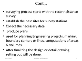
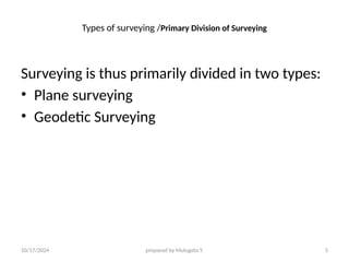
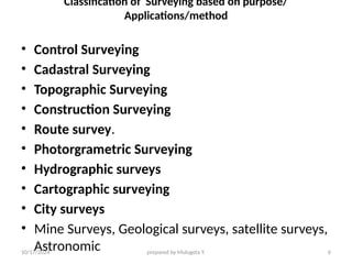
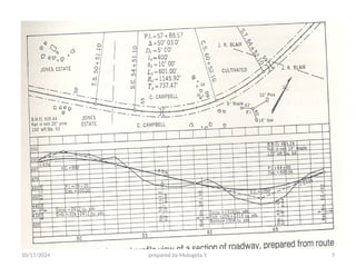
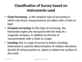
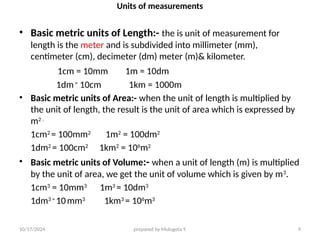
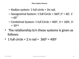
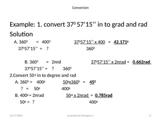
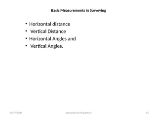
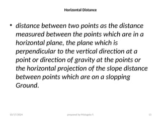
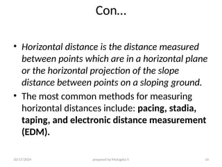
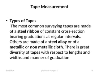
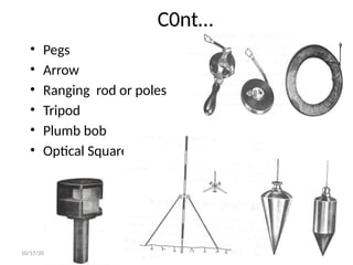
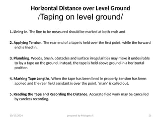
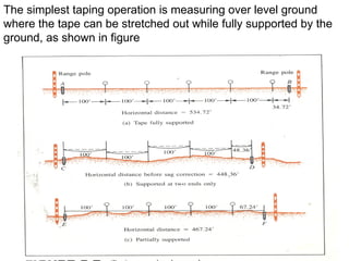
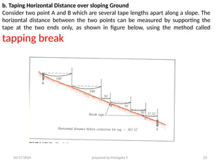
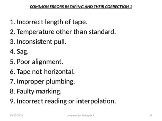
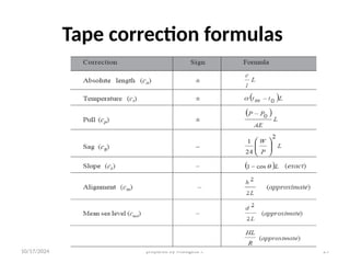
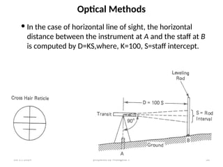
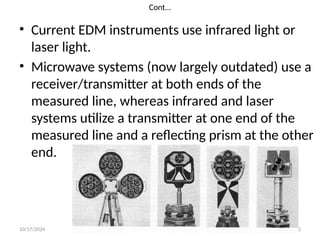
10/17/2024 prepared by Mulugeta Y. 1
Distance measurement
Definitions
• Surveying may be simply defined as the art of
making measurements. Surveying involves the
measurements of Distances, angles and
elevations.
• It also involves staking out the lines and grades
needed for the construction of buildings, roads,
dams, and other engineering structures.
• In addition to the field measurements, surveying
includes the computation of areas, volumes, and
the preparation of necessary maps and diagrams.
10/17/2024 prepared by Mulugeta Y. 2
Cont…
• More precisely, Surveying can be defined as the art and
Science of determining the relative positions of various
points on, above or below the surface of the earth.
• When we say the relative positions of points it means
that determining the relative positions of points in
reference to another point or reference point/station.
For example, Adama City is found at about 100
kilometers East of Addis Ababa . In this example, it is
obvious that the (relative position) location of Adama
city is described in reference to Addis Ababa and that of
Adama University is in reference to Adama City.
•
10/17/2024 prepared by Mulugeta Y. 3
Importance of Surveying
• Surveying plays an essential role in the
planning, design, layout and construction of
our physical environment and infrastructure.
• Roads, Bridges, Buildings, water supply
sewerage, drainage systems and many other
essential public works, projects could never be
built without surveying technology.
• in construction and land-use projects
10/17/2024 prepared by Mulugeta Y. 4
Cont…
• surveying process starts with the reconnaissance
survey
• establish the best sites for survey stations
• Collect the necessary data
• produce plans
• used for planning Engineering projects, marking
boundary corners or lines, computations of areas
& volumes
• After finalizing the design or detail drawing,
setting out will be done.
10/17/2024 prepared by Mulugeta Y. 5
Types of surveying /Primary Division of Surveying
Surveying is thus primarily divided in two types:
• Plane surveying
• Geodetic Surveying
10/17/2024 prepared by Mulugeta Y. 6
Classification of Surveying based on purpose/
Applications/method
• Control Surveying
• Cadastral Surveying
• Topographic Surveying
• Construction Surveying
• Route survey.
• Photorgrametric Surveying
• Hydrographic surveys
• Cartographic surveying
• City surveys
• Mine Surveys, Geological surveys, satellite surveys,
Astronomic
10/17/2024 prepared by Mulugeta Y. 7
10/17/2024 prepared by Mulugeta Y. 8
Classification of Survey based on
Instruments used
• Chain Surveying : is the simplest type of surveying in
which only linear measurements are taken with a chain or
tape
• Compass surveying: In this type of surveying, the
horizontal angles are measured with the help of a
magnetic compass, in addition to the line or
measurements with a chain or a tape.
• Leveling: this is a type of survey in which a leveling
Instrument is used for determination of relative elevations
(levels) of various points on, above or below the surface of
the earth
10/17/2024 prepared by Mulugeta Y. 9
Units of measurements
• Basic metric units of Length:- the is unit of measurement for
length is the meter and is subdivided into millimeter (mm),
centimeter (cm), decimeter (dm) meter (m)& kilometer.
1cm = 10mm 1m = 10dm
1dm=
10cm 1km = 1000m
• Basic metric units of Area:- when the unit of length is multiplied by
the unit of length, the result is the unit of area which is expressed by
m2 .
1cm2
= 100mm2
1m2
= 100dm2
1dm2
= 100cm2
1km2
= 106
m2
• Basic metric units of Volume:- when a unit of length (m) is multiplied
by the unit of area, we get the unit of volume which is given by m3
.
1cm3
= 10mm3
1m3
= 10dm3
1dm3 =
10mm3
1km3
= 106
m3
10/17/2024 prepared by Mulugeta Y. 10
Plane Angular Measure
– Radian system: 1 full circle = 2π rad.
– Sexagesimal System: 1 full Circle = 3600
,10
= 60’, 1’
= 60’’
– Centisimal System: 1 full Circle = 4000
, 1g
= 100g
, 1g
= 10mg
• The relationship b/n these systems is given as
follows:
• 1 full circle = 2 π rad = 3600
= 4000
10/17/2024 prepared by Mulugeta Y. 11
Conversion
Example: 1. convert 370
57’15’’ in to grad and rad
Solution
A. 3600
= 4000
370
57’15’’ x 400 = 42.171g
370
57’15’’ = ? 3600
B. 3600
= 2πrd 370
57’15’’ x 2πrad = 0.662rad.
370
57’15’’ = ? 3600
2.Convert 50g
in to degree and rad
A. 3600
= 400g
50g
x3600
= 450
? = 50g
400g
B. 400g
= 2πrad 50g
x 2πrad = 0.785rad
50g
= ? 400g
10/17/2024 prepared by Mulugeta Y. 12
Basic Measurements in Surveying
• Horizontal distance
• Vertical Distance
• Horizontal Angles and
• Vertical Angles.
10/17/2024 prepared by Mulugeta Y. 13
Horizontal Distance
• distance between two points as the distance
measured between the points which are in a
horizontal plane, the plane which is
perpendicular to the vertical direction at a
point or direction of gravity at the points or
the horizontal projection of the slope distance
between points which are on a slopping
Ground.
10/17/2024 prepared by Mulugeta Y. 14
Con…
• Horizontal distance is the distance measured
between points which are in a horizontal plane
or the horizontal projection of the slope
distance between points on a sloping ground.
• The most common methods for measuring
horizontal distances include: pacing, stadia,
taping, and electronic distance measurement
(EDM).
10/17/2024 prepared by Mulugeta Y. 15
Tape Measurement
• Types of Tapes
The most common surveying tapes are made
of a steel ribbon of constant cross-section
bearing graduations at regular intervals.
Others are made of a steel alloy or of a
metallic or non metallic cloth. There is great
diversity of tapes with respect to lengths and
widths and manner of graduation
10/17/2024 prepared by Mulugeta Y. 16
Con…
• steel alloy tapes, known as Invar or Lovar,
have a coefficient of thermal expansion about
one thirtieth that of steel and are used when
the taping specification prescribe a high order
of accuracy.
10/17/2024 prepared by Mulugeta Y. 17
Instruments &Taping Accessories
1. TAPE:- a tape is an instrument, mostly graduated in meter,
decimeter and centimeter, used for measuring accurate
lengths. Measuring tapes can be classified depending up on
the material in their man facture.
Eg. Linen tape, steel tape, invar tape, synthetic tape…
2. ARROWS (Chain pins):- they are used to mark the position of
the ends of the tape on the ground.
3. PEGS :- Wooden pegs are used to mark the position of the
survey station or the end points of the survey line.
4. RANGING RODS: - the process of locating a number of points
on a long survey is called ranging. Ranging rods are used to
locate intermediate points such that these points lie on the
straight line joining the end stations.
10/17/2024 prepared by Mulugeta Y. 18
Cont…
5. PLUMB BOBS:- They are made up of metal
used for fixing range poles vertically, centering
surveying instruments, and transferring pts
from tape to ground station while measuring
distance over sloping ground.
6. OPTICAL SQUARE: - it is a useful instrument
often used in combination with tape surveys
for producing rectangular angles (100gon or
900
).
10/17/2024 prepared by Mulugeta Y. 19
Taping Accessories
10/17/2024 prepared by Mulugeta Y. 20
C0nt…
• Pegs
• Arrow
• Ranging rod or poles
• Tripod
• Plumb bob
• Optical Square
10/17/2024 prepared by Mulugeta Y. 21
Horizontal Distance over Level Ground
/Taping on level ground/
1. Lining In. The line to be measured should be marked at both ends and
2. Applying Tension. The rear end of a tape is held over the first point, while the forward
end is lined in.
3. Plumbing. Weeds, brush, obstacles and surface irregularities may make it undesirable
to lay a tape on the ground. Instead, the tape is held above ground in a horizontal
position.
4. Marking Tape Lengths. When the tape has been lined in properly, tension has been
applied and the rear field assistant is over the point, 'mark' is called out.
5. Reading the Tape and Recording the Distance. Accurate field work may be cancelled
by careless recording.
10/17/2024 prepared by Mulugeta Y. 22
The simplest taping operation is measuring over level ground
where the tape can be stretched out while fully supported by the
ground, as shown in figure
10/17/2024 prepared by Mulugeta Y. 23
b. Taping Horizontal Distance over sloping Ground
Consider two point A and B which are several tape lengths apart along a slope. The
horizontal distance between the two points can be measured by supporting the
tape at the two ends only, as shown in figure below, using the method called
tapping break
.
10/17/2024 prepared by Mulugeta Y. 24
Taping Slope Distance
2
2
h
s
d 


Where d is the horizontal distance, s is the slope
distance, and is h the difference in height
between the two end points .
.
S h
d
10/17/2024 prepared by Mulugeta Y. 25
C0nt…
• Note that the accuracy of the computed horizontal
distance d depends on the accuracy of measured slope
distances & on the accuracy of the height difference h.
10/17/2024 prepared by Mulugeta Y. 26
Horizontal measurement on uneven ground
10/17/2024 prepared by Mulugeta Y. 27
Errors in Linear measurements and their corrections
• Errors of measurements are of three kinds:
• 1. MISTKES- mistakes are errors that arise from inattention,
inexperience, carelessness and poor judgment or confusion in the mind
of the observer.
• 2. SYSTEMATIC ERRORS- they always follow some definite mathematical
or physical law, and a correction can be determined and applied.
• Eg. The error in the length of the steel tape due to change in
temperature is a systematic error.
• RANDOM (ACCIDENTAL) ERRORS:- are those which remain after
mistakes and systematic errors have been eliminated and are caused by
a combination of errors.
• represent the limit of precision in the determination of a value, i.e., due
to lack of perfection in the human eye.
• E.g. In measuring a distance with a scale tape marked in centimeters,
one has to estimate a distance of 5mm as 6mm or 4mm because the eye
cannot judge the exact division.
10/17/2024 prepared by Mulugeta Y. 28
COMMON ERRORS IN TAPING AND THEIR CORRECTION 1
1. Incorrect length of tape.
2. Temperature other than standard.
3. Inconsistent pull.
4. Sag.
5. Poor alignment.
6. Tape not horizontal.
7. Improper plumbing.
8. Faulty marking.
9. Incorrect reading or interpolation.
10/17/2024 prepared by Mulugeta Y. 29
Tape correction formulas
10/17/2024 prepared by Mulugeta Y. 30
Optical Methods
 In the case of horizontal line of sight, the horizontal
distance between the instrument at A and the staff at B
is computed by D=KS,where, K=100, S=staff intercept.
10/17/2024 prepared by Mulugeta Y. 31
Electronic Distance Measurement
• Electronic distance measurement (EDM),
introduced in the 1950s
• The EDM equipments which are commonly used
are mainly electronic or microwave systems and
electro-optical instruments.
• EDM instruments are manufactured for use with
theodolites and as integral or modular
components of total station instruments.
10/17/2024 prepared by Mulugeta Y. 32
Cont…
• Current EDM instruments use infrared light or
laser light.
• Microwave systems (now largely outdated) use a
receiver/transmitter at both ends of the
measured line, whereas infrared and laser
systems utilize a transmitter at one end of the
measured line and a reflecting prism at the other
end.

linear measurement introduction(part1) Arc.pptx

  • 1.
    10/17/2024 prepared byMulugeta Y. 1 Distance measurement Definitions • Surveying may be simply defined as the art of making measurements. Surveying involves the measurements of Distances, angles and elevations. • It also involves staking out the lines and grades needed for the construction of buildings, roads, dams, and other engineering structures. • In addition to the field measurements, surveying includes the computation of areas, volumes, and the preparation of necessary maps and diagrams.
  • 2.
    10/17/2024 prepared byMulugeta Y. 2 Cont… • More precisely, Surveying can be defined as the art and Science of determining the relative positions of various points on, above or below the surface of the earth. • When we say the relative positions of points it means that determining the relative positions of points in reference to another point or reference point/station. For example, Adama City is found at about 100 kilometers East of Addis Ababa . In this example, it is obvious that the (relative position) location of Adama city is described in reference to Addis Ababa and that of Adama University is in reference to Adama City. •
  • 3.
    10/17/2024 prepared byMulugeta Y. 3 Importance of Surveying • Surveying plays an essential role in the planning, design, layout and construction of our physical environment and infrastructure. • Roads, Bridges, Buildings, water supply sewerage, drainage systems and many other essential public works, projects could never be built without surveying technology. • in construction and land-use projects
  • 4.
    10/17/2024 prepared byMulugeta Y. 4 Cont… • surveying process starts with the reconnaissance survey • establish the best sites for survey stations • Collect the necessary data • produce plans • used for planning Engineering projects, marking boundary corners or lines, computations of areas & volumes • After finalizing the design or detail drawing, setting out will be done.
  • 5.
    10/17/2024 prepared byMulugeta Y. 5 Types of surveying /Primary Division of Surveying Surveying is thus primarily divided in two types: • Plane surveying • Geodetic Surveying
  • 6.
    10/17/2024 prepared byMulugeta Y. 6 Classification of Surveying based on purpose/ Applications/method • Control Surveying • Cadastral Surveying • Topographic Surveying • Construction Surveying • Route survey. • Photorgrametric Surveying • Hydrographic surveys • Cartographic surveying • City surveys • Mine Surveys, Geological surveys, satellite surveys, Astronomic
  • 7.
  • 8.
    10/17/2024 prepared byMulugeta Y. 8 Classification of Survey based on Instruments used • Chain Surveying : is the simplest type of surveying in which only linear measurements are taken with a chain or tape • Compass surveying: In this type of surveying, the horizontal angles are measured with the help of a magnetic compass, in addition to the line or measurements with a chain or a tape. • Leveling: this is a type of survey in which a leveling Instrument is used for determination of relative elevations (levels) of various points on, above or below the surface of the earth
  • 9.
    10/17/2024 prepared byMulugeta Y. 9 Units of measurements • Basic metric units of Length:- the is unit of measurement for length is the meter and is subdivided into millimeter (mm), centimeter (cm), decimeter (dm) meter (m)& kilometer. 1cm = 10mm 1m = 10dm 1dm= 10cm 1km = 1000m • Basic metric units of Area:- when the unit of length is multiplied by the unit of length, the result is the unit of area which is expressed by m2 . 1cm2 = 100mm2 1m2 = 100dm2 1dm2 = 100cm2 1km2 = 106 m2 • Basic metric units of Volume:- when a unit of length (m) is multiplied by the unit of area, we get the unit of volume which is given by m3 . 1cm3 = 10mm3 1m3 = 10dm3 1dm3 = 10mm3 1km3 = 106 m3
  • 10.
    10/17/2024 prepared byMulugeta Y. 10 Plane Angular Measure – Radian system: 1 full circle = 2π rad. – Sexagesimal System: 1 full Circle = 3600 ,10 = 60’, 1’ = 60’’ – Centisimal System: 1 full Circle = 4000 , 1g = 100g , 1g = 10mg • The relationship b/n these systems is given as follows: • 1 full circle = 2 π rad = 3600 = 4000
  • 11.
    10/17/2024 prepared byMulugeta Y. 11 Conversion Example: 1. convert 370 57’15’’ in to grad and rad Solution A. 3600 = 4000 370 57’15’’ x 400 = 42.171g 370 57’15’’ = ? 3600 B. 3600 = 2πrd 370 57’15’’ x 2πrad = 0.662rad. 370 57’15’’ = ? 3600 2.Convert 50g in to degree and rad A. 3600 = 400g 50g x3600 = 450 ? = 50g 400g B. 400g = 2πrad 50g x 2πrad = 0.785rad 50g = ? 400g
  • 12.
    10/17/2024 prepared byMulugeta Y. 12 Basic Measurements in Surveying • Horizontal distance • Vertical Distance • Horizontal Angles and • Vertical Angles.
  • 13.
    10/17/2024 prepared byMulugeta Y. 13 Horizontal Distance • distance between two points as the distance measured between the points which are in a horizontal plane, the plane which is perpendicular to the vertical direction at a point or direction of gravity at the points or the horizontal projection of the slope distance between points which are on a slopping Ground.
  • 14.
    10/17/2024 prepared byMulugeta Y. 14 Con… • Horizontal distance is the distance measured between points which are in a horizontal plane or the horizontal projection of the slope distance between points on a sloping ground. • The most common methods for measuring horizontal distances include: pacing, stadia, taping, and electronic distance measurement (EDM).
  • 15.
    10/17/2024 prepared byMulugeta Y. 15 Tape Measurement • Types of Tapes The most common surveying tapes are made of a steel ribbon of constant cross-section bearing graduations at regular intervals. Others are made of a steel alloy or of a metallic or non metallic cloth. There is great diversity of tapes with respect to lengths and widths and manner of graduation
  • 16.
    10/17/2024 prepared byMulugeta Y. 16 Con… • steel alloy tapes, known as Invar or Lovar, have a coefficient of thermal expansion about one thirtieth that of steel and are used when the taping specification prescribe a high order of accuracy.
  • 17.
    10/17/2024 prepared byMulugeta Y. 17 Instruments &Taping Accessories 1. TAPE:- a tape is an instrument, mostly graduated in meter, decimeter and centimeter, used for measuring accurate lengths. Measuring tapes can be classified depending up on the material in their man facture. Eg. Linen tape, steel tape, invar tape, synthetic tape… 2. ARROWS (Chain pins):- they are used to mark the position of the ends of the tape on the ground. 3. PEGS :- Wooden pegs are used to mark the position of the survey station or the end points of the survey line. 4. RANGING RODS: - the process of locating a number of points on a long survey is called ranging. Ranging rods are used to locate intermediate points such that these points lie on the straight line joining the end stations.
  • 18.
    10/17/2024 prepared byMulugeta Y. 18 Cont… 5. PLUMB BOBS:- They are made up of metal used for fixing range poles vertically, centering surveying instruments, and transferring pts from tape to ground station while measuring distance over sloping ground. 6. OPTICAL SQUARE: - it is a useful instrument often used in combination with tape surveys for producing rectangular angles (100gon or 900 ).
  • 19.
    10/17/2024 prepared byMulugeta Y. 19 Taping Accessories
  • 20.
    10/17/2024 prepared byMulugeta Y. 20 C0nt… • Pegs • Arrow • Ranging rod or poles • Tripod • Plumb bob • Optical Square
  • 21.
    10/17/2024 prepared byMulugeta Y. 21 Horizontal Distance over Level Ground /Taping on level ground/ 1. Lining In. The line to be measured should be marked at both ends and 2. Applying Tension. The rear end of a tape is held over the first point, while the forward end is lined in. 3. Plumbing. Weeds, brush, obstacles and surface irregularities may make it undesirable to lay a tape on the ground. Instead, the tape is held above ground in a horizontal position. 4. Marking Tape Lengths. When the tape has been lined in properly, tension has been applied and the rear field assistant is over the point, 'mark' is called out. 5. Reading the Tape and Recording the Distance. Accurate field work may be cancelled by careless recording.
  • 22.
    10/17/2024 prepared byMulugeta Y. 22 The simplest taping operation is measuring over level ground where the tape can be stretched out while fully supported by the ground, as shown in figure
  • 23.
    10/17/2024 prepared byMulugeta Y. 23 b. Taping Horizontal Distance over sloping Ground Consider two point A and B which are several tape lengths apart along a slope. The horizontal distance between the two points can be measured by supporting the tape at the two ends only, as shown in figure below, using the method called tapping break .
  • 24.
    10/17/2024 prepared byMulugeta Y. 24 Taping Slope Distance 2 2 h s d    Where d is the horizontal distance, s is the slope distance, and is h the difference in height between the two end points . . S h d
  • 25.
    10/17/2024 prepared byMulugeta Y. 25 C0nt… • Note that the accuracy of the computed horizontal distance d depends on the accuracy of measured slope distances & on the accuracy of the height difference h.
  • 26.
    10/17/2024 prepared byMulugeta Y. 26 Horizontal measurement on uneven ground
  • 27.
    10/17/2024 prepared byMulugeta Y. 27 Errors in Linear measurements and their corrections • Errors of measurements are of three kinds: • 1. MISTKES- mistakes are errors that arise from inattention, inexperience, carelessness and poor judgment or confusion in the mind of the observer. • 2. SYSTEMATIC ERRORS- they always follow some definite mathematical or physical law, and a correction can be determined and applied. • Eg. The error in the length of the steel tape due to change in temperature is a systematic error. • RANDOM (ACCIDENTAL) ERRORS:- are those which remain after mistakes and systematic errors have been eliminated and are caused by a combination of errors. • represent the limit of precision in the determination of a value, i.e., due to lack of perfection in the human eye. • E.g. In measuring a distance with a scale tape marked in centimeters, one has to estimate a distance of 5mm as 6mm or 4mm because the eye cannot judge the exact division.
  • 28.
    10/17/2024 prepared byMulugeta Y. 28 COMMON ERRORS IN TAPING AND THEIR CORRECTION 1 1. Incorrect length of tape. 2. Temperature other than standard. 3. Inconsistent pull. 4. Sag. 5. Poor alignment. 6. Tape not horizontal. 7. Improper plumbing. 8. Faulty marking. 9. Incorrect reading or interpolation.
  • 29.
    10/17/2024 prepared byMulugeta Y. 29 Tape correction formulas
  • 30.
    10/17/2024 prepared byMulugeta Y. 30 Optical Methods  In the case of horizontal line of sight, the horizontal distance between the instrument at A and the staff at B is computed by D=KS,where, K=100, S=staff intercept.
  • 31.
    10/17/2024 prepared byMulugeta Y. 31 Electronic Distance Measurement • Electronic distance measurement (EDM), introduced in the 1950s • The EDM equipments which are commonly used are mainly electronic or microwave systems and electro-optical instruments. • EDM instruments are manufactured for use with theodolites and as integral or modular components of total station instruments.
  • 32.
    10/17/2024 prepared byMulugeta Y. 32 Cont… • Current EDM instruments use infrared light or laser light. • Microwave systems (now largely outdated) use a receiver/transmitter at both ends of the measured line, whereas infrared and laser systems utilize a transmitter at one end of the measured line and a reflecting prism at the other end.