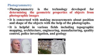
SlideShare a Scribd company logo
1 of 17
Geo-informatics- definition, concepts, tools
and techniques and their use in Precision
Agriculture.
Dr. H.A. Archana
Assistant Professor
Definition:
• Geoinformatics is the technology and science of developing
information infrastructure to address the challenges that face
geography, geosciences, and cartography, among other related
branches of science and engineering.
• It deals primarily with the character and structure of spatial
information, and its classification, qualification, storage,
processing, and dissemination.
• Geoinformatics is one of the powerful technologies to support
basic scientific inquiry as well as address the complex social
and environmental challenges through data analysis.
Concepts:
• It collects and organize the data and then analyse it
through computation and geo-visualization.
• The realm of Geoinformatics is very broad because it
comprises of subjects like Remote sensing, GPS, GIS,
cartography, hydrology, climatology, Aerial photography,
photogrammetry etc.
Tools and Techniques
i. Computer science
ii. Geodesy
iii. Cartography
iv. Photogrammetry
v. Remote Sensing
vi. Global positioning system
vii.Geographical Information System
Computer science
• Informatics, as discipline, comprises of both the computer
technologies, i.e. hardware and software
• Necessity to manage more and more numerous data in
every field including agriculture
• The knowledge of computer science is a pre- requisite to
represent and process applicable information through the
development of hardware and software
• Computer science- contributing in improvement of our
activities and research
Geodesy
• Geodesy is the discipline deals with measurement and
representation of the earth
• It is defined as the science concerned with the study of
shape, dimension, gravity and area of the earth
• Branches- Gravimetry and positioning astronomy
Cartography
• It is the art and science of designing, constructing and
producing maps
• It includes almost every operation from original field
work to final printing and marketing of maps
Photogrammetry
• Photogrammetry is the technology developed for
determining the geometric properties of objects from
photographic images
• It is concerned with making measurements about position
and shape of the objects with the help of the photographs.
• It is helpful in various fields including topographic
mapping, architecture, engineering, manufacturing, quality
control, police investigation, and geology
Remote sensing
• Remote sensing is the collection of data about an object from
a distance
• It is used to measure and monitor the Earths lithosphere,
biosphere, hydrosphere, and atmosphere.
• Humans and many other types of animals accomplish this
task with aid of eye or by the sense of smell or hearing.
• Remote sensing is usually done with the help of mechanical
device known as remote sensor.
• This device as greatly improved ability to receive and record
information about an object without having any physical
contact with them by using electromagnetic energy radiation
Global positioning system
• GPS enables positional accuracy in the location of terrain
features
• It receives signals and positioning information from a
series of satellites in space
• GPS gives the accurate location of soil sample points
within a field.
• It also required to establish the accurate location of yield
data collected.
• Real world application – Location, Navigation, Tracking,
Mapping, etc.,
Geographic information system
• GIS – It is a system for capturing, storing, checking,
manipulating, analyzing, and displaying data, which are
spatially referenced to the earth.
• GIS as been used for emergency panning, logistics and
transportation related analysis, crime analysis, business
and service planning, government and public services,
analysis of genome sequences on DNA.
• Components of GIS- Hardware, spatial database,
software, procedure, Expertise
Applications of Geoinformatics
1. It is used for urban planning and land use management.
2. It is used for car navigation.
3. It is used for creating virtual globes.
4. It is used for environmental modelling and analysis.
5. It is used in agriculture, meteorology and to study the climate
change.
6. It is used for oceanography and atmosphere modelling.
7. It is used in telecommunications, criminology and crime
simulation.
8. It is used in aviation, biodiversity conservation and maritime
transport.
9. It is used in disaster risk management.
Use of Geoinformatics in precision agriculture
• Precision Farming, basically, is characterized by reduced cost of
cultivation (through optimization of inputs), improved control and
increased resource use efficiency, through appropriate
applications of Management Information System (MIS).
• While the reduced cost of cultivation is achieved through
optimization of agricultural inputs taking into account economic
push and environmental pull related factors, the control
mechanisms are introduced by the help of Geo Informatics
Application of Geoinformatics in precision Agriculture
• Gathering of information on agricultural activities, including land
use, soil condition, weather condition, etc., that are essential for
site characterization and consequent site selection for farming.
• Capability of recording date in visible as well as invisible
(including UV, IR, MW) parts of the spectrum, it enables us to see
beyond the capability of the human eye eg. Disease and pest attack
• It is useful in the determination of the spatial distribution of plant
status and expected yield by measuring the greenness of the field.
• Detection, identification, measurement and monitoring of
agricultural phenomena are predicted on the assumption that
agricultural landscape features (such as crops, livestock, crop
infestation, and soil anomalies) have consistently identifiable
signatures on the type of remote sensing data.
• These identifiable signatures are a reflection of crop type, state of
maturity, crop density, crop geometry, crop vigour, crop moisture,
crop temperature, and soil moisture as well as soil temperature
• Agricultural survey- Crop Survey, Range survey, Livestock survey
Lec 3.pptx

More Related Content

Similar to Lec 3.pptx

Geographic information system (GIS) and its application in precision farming
Geographic information system (GIS) and its application in precision farmingGeographic information system (GIS) and its application in precision farming
Geographic information system (GIS) and its application in precision farmingDr. M. Kumaresan Hort.
 
Geoinformatics
GeoinformaticsGeoinformatics
Geoinformaticsgeovino
 
Introduction to Geoinformatics
Introduction to GeoinformaticsIntroduction to Geoinformatics
Introduction to GeoinformaticsKU Leuven
 
Remote sensing and tunneling.pptx
Remote sensing and tunneling.pptxRemote sensing and tunneling.pptx
Remote sensing and tunneling.pptxpandieswarim1
 
Application of Geo-informatics in Environmental Management
Application of Geo-informatics in Environmental ManagementApplication of Geo-informatics in Environmental Management
Application of Geo-informatics in Environmental ManagementMahaMadhu2
 
GIS & RS in Forest Mapping
GIS & RS in Forest MappingGIS & RS in Forest Mapping
GIS & RS in Forest MappingKamlesh Kumar
 
Thematic maps, spatial variability, mobile mapping systems and its applicatio...
Thematic maps, spatial variability, mobile mapping systems and its applicatio...Thematic maps, spatial variability, mobile mapping systems and its applicatio...
Thematic maps, spatial variability, mobile mapping systems and its applicatio...Dr. M. Kumaresan Hort.
 
GIS and GPS - applications in civil engg
GIS and GPS - applications  in civil enggGIS and GPS - applications  in civil engg
GIS and GPS - applications in civil enggPundlik Rathod
 
Remote Sensing and GIS techniques.pptx
Remote Sensing and GIS techniques.pptxRemote Sensing and GIS techniques.pptx
Remote Sensing and GIS techniques.pptxDebashisSatapathy2
 
Introduction of GIS & Remote Sensing (RS)
Introduction of GIS & Remote Sensing (RS)Introduction of GIS & Remote Sensing (RS)
Introduction of GIS & Remote Sensing (RS)Subtain Hussain Syed
 
Remote sensing and gis ppt
Remote sensing and gis pptRemote sensing and gis ppt
Remote sensing and gis pptpreeti patil
 
RS_GIS_Crop_monitoring-converted.pptx
RS_GIS_Crop_monitoring-converted.pptxRS_GIS_Crop_monitoring-converted.pptx
RS_GIS_Crop_monitoring-converted.pptxSouvikPal60
 
remote sensing and (GIS)
remote sensing and (GIS) remote sensing and (GIS)
remote sensing and (GIS) Anshul Phaugat
 
Geographic Information System for Bachelor in Agriculture Engineering
Geographic Information System for Bachelor in Agriculture EngineeringGeographic Information System for Bachelor in Agriculture Engineering
Geographic Information System for Bachelor in Agriculture EngineeringDinesh Bishwakarma
 

Similar to Lec 3.pptx (20)

Geographic information system (GIS) and its application in precision farming
Geographic information system (GIS) and its application in precision farmingGeographic information system (GIS) and its application in precision farming
Geographic information system (GIS) and its application in precision farming
 
GIS and Remote Sensing
GIS and Remote SensingGIS and Remote Sensing
GIS and Remote Sensing
 
Remote sensing
Remote sensingRemote sensing
Remote sensing
 
Geoinformatics
GeoinformaticsGeoinformatics
Geoinformatics
 
Introduction to Geoinformatics
Introduction to GeoinformaticsIntroduction to Geoinformatics
Introduction to Geoinformatics
 
Precision Farming by Dr. Pooja Goswami
Precision Farming by Dr. Pooja GoswamiPrecision Farming by Dr. Pooja Goswami
Precision Farming by Dr. Pooja Goswami
 
Remote sensing and tunneling.pptx
Remote sensing and tunneling.pptxRemote sensing and tunneling.pptx
Remote sensing and tunneling.pptx
 
Application of Geo-informatics in Environmental Management
Application of Geo-informatics in Environmental ManagementApplication of Geo-informatics in Environmental Management
Application of Geo-informatics in Environmental Management
 
geoststistics
geoststisticsgeoststistics
geoststistics
 
GIS & RS in Forest Mapping
GIS & RS in Forest MappingGIS & RS in Forest Mapping
GIS & RS in Forest Mapping
 
gis-unit1_2.pdf
gis-unit1_2.pdfgis-unit1_2.pdf
gis-unit1_2.pdf
 
GIS in Health
GIS in HealthGIS in Health
GIS in Health
 
Thematic maps, spatial variability, mobile mapping systems and its applicatio...
Thematic maps, spatial variability, mobile mapping systems and its applicatio...Thematic maps, spatial variability, mobile mapping systems and its applicatio...
Thematic maps, spatial variability, mobile mapping systems and its applicatio...
 
GIS and GPS - applications in civil engg
GIS and GPS - applications  in civil enggGIS and GPS - applications  in civil engg
GIS and GPS - applications in civil engg
 
Remote Sensing and GIS techniques.pptx
Remote Sensing and GIS techniques.pptxRemote Sensing and GIS techniques.pptx
Remote Sensing and GIS techniques.pptx
 
Introduction of GIS & Remote Sensing (RS)
Introduction of GIS & Remote Sensing (RS)Introduction of GIS & Remote Sensing (RS)
Introduction of GIS & Remote Sensing (RS)
 
Remote sensing and gis ppt
Remote sensing and gis pptRemote sensing and gis ppt
Remote sensing and gis ppt
 
RS_GIS_Crop_monitoring-converted.pptx
RS_GIS_Crop_monitoring-converted.pptxRS_GIS_Crop_monitoring-converted.pptx
RS_GIS_Crop_monitoring-converted.pptx
 
remote sensing and (GIS)
remote sensing and (GIS) remote sensing and (GIS)
remote sensing and (GIS)
 
Geographic Information System for Bachelor in Agriculture Engineering
Geographic Information System for Bachelor in Agriculture EngineeringGeographic Information System for Bachelor in Agriculture Engineering
Geographic Information System for Bachelor in Agriculture Engineering
 

Recently uploaded

Call Girls in Dwarka Mor Delhi Contact Us 9654467111
Call Girls in Dwarka Mor Delhi Contact Us 9654467111Call Girls in Dwarka Mor Delhi Contact Us 9654467111
Call Girls in Dwarka Mor Delhi Contact Us 9654467111Sapana Sha
 
A Critique of the Proposed National Education Policy Reform
A Critique of the Proposed National Education Policy ReformA Critique of the Proposed National Education Policy Reform
A Critique of the Proposed National Education Policy ReformChameera Dedduwage
 
Introduction to Nonprofit Accounting: The Basics
Introduction to Nonprofit Accounting: The BasicsIntroduction to Nonprofit Accounting: The Basics
Introduction to Nonprofit Accounting: The BasicsTechSoup
 
Ecosystem Interactions Class Discussion Presentation in Blue Green Lined Styl...
Ecosystem Interactions Class Discussion Presentation in Blue Green Lined Styl...Ecosystem Interactions Class Discussion Presentation in Blue Green Lined Styl...
Ecosystem Interactions Class Discussion Presentation in Blue Green Lined Styl...fonyou31
 
The basics of sentences session 2pptx copy.pptx
The basics of sentences session 2pptx copy.pptxThe basics of sentences session 2pptx copy.pptx
The basics of sentences session 2pptx copy.pptxheathfieldcps1
 
Russian Call Girls in Andheri Airport Mumbai WhatsApp 9167673311 💞 Full Nigh...
Russian Call Girls in Andheri Airport Mumbai WhatsApp  9167673311 💞 Full Nigh...Russian Call Girls in Andheri Airport Mumbai WhatsApp  9167673311 💞 Full Nigh...
Russian Call Girls in Andheri Airport Mumbai WhatsApp 9167673311 💞 Full Nigh...Pooja Nehwal
 
Interactive Powerpoint_How to Master effective communication
Interactive Powerpoint_How to Master effective communicationInteractive Powerpoint_How to Master effective communication
Interactive Powerpoint_How to Master effective communicationnomboosow
 
Grant Readiness 101 TechSoup and Remy Consulting
Grant Readiness 101 TechSoup and Remy ConsultingGrant Readiness 101 TechSoup and Remy Consulting
Grant Readiness 101 TechSoup and Remy ConsultingTechSoup
 
Arihant handbook biology for class 11 .pdf
Arihant handbook biology for class 11 .pdfArihant handbook biology for class 11 .pdf
Arihant handbook biology for class 11 .pdfchloefrazer622
 
SOCIAL AND HISTORICAL CONTEXT - LFTVD.pptx
SOCIAL AND HISTORICAL CONTEXT - LFTVD.pptxSOCIAL AND HISTORICAL CONTEXT - LFTVD.pptx
SOCIAL AND HISTORICAL CONTEXT - LFTVD.pptxiammrhaywood
 
1029-Danh muc Sach Giao Khoa khoi 6.pdf
1029-Danh muc Sach Giao Khoa khoi  6.pdf1029-Danh muc Sach Giao Khoa khoi  6.pdf
1029-Danh muc Sach Giao Khoa khoi 6.pdfQucHHunhnh
 
Paris 2024 Olympic Geographies - an activity
Paris 2024 Olympic Geographies - an activityParis 2024 Olympic Geographies - an activity
Paris 2024 Olympic Geographies - an activityGeoBlogs
 
CARE OF CHILD IN INCUBATOR..........pptx
CARE OF CHILD IN INCUBATOR..........pptxCARE OF CHILD IN INCUBATOR..........pptx
CARE OF CHILD IN INCUBATOR..........pptxGaneshChakor2
 
APM Welcome, APM North West Network Conference, Synergies Across Sectors
APM Welcome, APM North West Network Conference, Synergies Across SectorsAPM Welcome, APM North West Network Conference, Synergies Across Sectors
APM Welcome, APM North West Network Conference, Synergies Across SectorsAssociation for Project Management
 
Measures of Dispersion and Variability: Range, QD, AD and SD
Measures of Dispersion and Variability: Range, QD, AD and SDMeasures of Dispersion and Variability: Range, QD, AD and SD
Measures of Dispersion and Variability: Range, QD, AD and SDThiyagu K
 
POINT- BIOCHEMISTRY SEM 2 ENZYMES UNIT 5.pptx
POINT- BIOCHEMISTRY SEM 2 ENZYMES UNIT 5.pptxPOINT- BIOCHEMISTRY SEM 2 ENZYMES UNIT 5.pptx
POINT- BIOCHEMISTRY SEM 2 ENZYMES UNIT 5.pptxSayali Powar
 
social pharmacy d-pharm 1st year by Pragati K. Mahajan
social pharmacy d-pharm 1st year by Pragati K. Mahajansocial pharmacy d-pharm 1st year by Pragati K. Mahajan
social pharmacy d-pharm 1st year by Pragati K. Mahajanpragatimahajan3
 

Recently uploaded (20)

Call Girls in Dwarka Mor Delhi Contact Us 9654467111
Call Girls in Dwarka Mor Delhi Contact Us 9654467111Call Girls in Dwarka Mor Delhi Contact Us 9654467111
Call Girls in Dwarka Mor Delhi Contact Us 9654467111
 
A Critique of the Proposed National Education Policy Reform
A Critique of the Proposed National Education Policy ReformA Critique of the Proposed National Education Policy Reform
A Critique of the Proposed National Education Policy Reform
 
Introduction to Nonprofit Accounting: The Basics
Introduction to Nonprofit Accounting: The BasicsIntroduction to Nonprofit Accounting: The Basics
Introduction to Nonprofit Accounting: The Basics
 
Ecosystem Interactions Class Discussion Presentation in Blue Green Lined Styl...
Ecosystem Interactions Class Discussion Presentation in Blue Green Lined Styl...Ecosystem Interactions Class Discussion Presentation in Blue Green Lined Styl...
Ecosystem Interactions Class Discussion Presentation in Blue Green Lined Styl...
 
The basics of sentences session 2pptx copy.pptx
The basics of sentences session 2pptx copy.pptxThe basics of sentences session 2pptx copy.pptx
The basics of sentences session 2pptx copy.pptx
 
Mattingly "AI & Prompt Design: Structured Data, Assistants, & RAG"
Mattingly "AI & Prompt Design: Structured Data, Assistants, & RAG"Mattingly "AI & Prompt Design: Structured Data, Assistants, & RAG"
Mattingly "AI & Prompt Design: Structured Data, Assistants, & RAG"
 
Russian Call Girls in Andheri Airport Mumbai WhatsApp 9167673311 💞 Full Nigh...
Russian Call Girls in Andheri Airport Mumbai WhatsApp  9167673311 💞 Full Nigh...Russian Call Girls in Andheri Airport Mumbai WhatsApp  9167673311 💞 Full Nigh...
Russian Call Girls in Andheri Airport Mumbai WhatsApp 9167673311 💞 Full Nigh...
 
Interactive Powerpoint_How to Master effective communication
Interactive Powerpoint_How to Master effective communicationInteractive Powerpoint_How to Master effective communication
Interactive Powerpoint_How to Master effective communication
 
Grant Readiness 101 TechSoup and Remy Consulting
Grant Readiness 101 TechSoup and Remy ConsultingGrant Readiness 101 TechSoup and Remy Consulting
Grant Readiness 101 TechSoup and Remy Consulting
 
Arihant handbook biology for class 11 .pdf
Arihant handbook biology for class 11 .pdfArihant handbook biology for class 11 .pdf
Arihant handbook biology for class 11 .pdf
 
SOCIAL AND HISTORICAL CONTEXT - LFTVD.pptx
SOCIAL AND HISTORICAL CONTEXT - LFTVD.pptxSOCIAL AND HISTORICAL CONTEXT - LFTVD.pptx
SOCIAL AND HISTORICAL CONTEXT - LFTVD.pptx
 
Advance Mobile Application Development class 07
Advance Mobile Application Development class 07Advance Mobile Application Development class 07
Advance Mobile Application Development class 07
 
1029-Danh muc Sach Giao Khoa khoi 6.pdf
1029-Danh muc Sach Giao Khoa khoi  6.pdf1029-Danh muc Sach Giao Khoa khoi  6.pdf
1029-Danh muc Sach Giao Khoa khoi 6.pdf
 
Paris 2024 Olympic Geographies - an activity
Paris 2024 Olympic Geographies - an activityParis 2024 Olympic Geographies - an activity
Paris 2024 Olympic Geographies - an activity
 
Código Creativo y Arte de Software | Unidad 1
Código Creativo y Arte de Software | Unidad 1Código Creativo y Arte de Software | Unidad 1
Código Creativo y Arte de Software | Unidad 1
 
CARE OF CHILD IN INCUBATOR..........pptx
CARE OF CHILD IN INCUBATOR..........pptxCARE OF CHILD IN INCUBATOR..........pptx
CARE OF CHILD IN INCUBATOR..........pptx
 
APM Welcome, APM North West Network Conference, Synergies Across Sectors
APM Welcome, APM North West Network Conference, Synergies Across SectorsAPM Welcome, APM North West Network Conference, Synergies Across Sectors
APM Welcome, APM North West Network Conference, Synergies Across Sectors
 
Measures of Dispersion and Variability: Range, QD, AD and SD
Measures of Dispersion and Variability: Range, QD, AD and SDMeasures of Dispersion and Variability: Range, QD, AD and SD
Measures of Dispersion and Variability: Range, QD, AD and SD
 
POINT- BIOCHEMISTRY SEM 2 ENZYMES UNIT 5.pptx
POINT- BIOCHEMISTRY SEM 2 ENZYMES UNIT 5.pptxPOINT- BIOCHEMISTRY SEM 2 ENZYMES UNIT 5.pptx
POINT- BIOCHEMISTRY SEM 2 ENZYMES UNIT 5.pptx
 
social pharmacy d-pharm 1st year by Pragati K. Mahajan
social pharmacy d-pharm 1st year by Pragati K. Mahajansocial pharmacy d-pharm 1st year by Pragati K. Mahajan
social pharmacy d-pharm 1st year by Pragati K. Mahajan
 

Lec 3.pptx

  • 1. Geo-informatics- definition, concepts, tools and techniques and their use in Precision Agriculture. Dr. H.A. Archana Assistant Professor
  • 2. Definition: • Geoinformatics is the technology and science of developing information infrastructure to address the challenges that face geography, geosciences, and cartography, among other related branches of science and engineering. • It deals primarily with the character and structure of spatial information, and its classification, qualification, storage, processing, and dissemination. • Geoinformatics is one of the powerful technologies to support basic scientific inquiry as well as address the complex social and environmental challenges through data analysis.
  • 3. Concepts: • It collects and organize the data and then analyse it through computation and geo-visualization. • The realm of Geoinformatics is very broad because it comprises of subjects like Remote sensing, GPS, GIS, cartography, hydrology, climatology, Aerial photography, photogrammetry etc.
  • 4. Tools and Techniques i. Computer science ii. Geodesy iii. Cartography iv. Photogrammetry v. Remote Sensing vi. Global positioning system vii.Geographical Information System
  • 5. Computer science • Informatics, as discipline, comprises of both the computer technologies, i.e. hardware and software • Necessity to manage more and more numerous data in every field including agriculture • The knowledge of computer science is a pre- requisite to represent and process applicable information through the development of hardware and software • Computer science- contributing in improvement of our activities and research
  • 6. Geodesy • Geodesy is the discipline deals with measurement and representation of the earth • It is defined as the science concerned with the study of shape, dimension, gravity and area of the earth • Branches- Gravimetry and positioning astronomy
  • 7. Cartography • It is the art and science of designing, constructing and producing maps • It includes almost every operation from original field work to final printing and marketing of maps
  • 8. Photogrammetry • Photogrammetry is the technology developed for determining the geometric properties of objects from photographic images • It is concerned with making measurements about position and shape of the objects with the help of the photographs. • It is helpful in various fields including topographic mapping, architecture, engineering, manufacturing, quality control, police investigation, and geology
  • 9. Remote sensing • Remote sensing is the collection of data about an object from a distance • It is used to measure and monitor the Earths lithosphere, biosphere, hydrosphere, and atmosphere. • Humans and many other types of animals accomplish this task with aid of eye or by the sense of smell or hearing. • Remote sensing is usually done with the help of mechanical device known as remote sensor. • This device as greatly improved ability to receive and record information about an object without having any physical contact with them by using electromagnetic energy radiation
  • 10. Global positioning system • GPS enables positional accuracy in the location of terrain features • It receives signals and positioning information from a series of satellites in space • GPS gives the accurate location of soil sample points within a field. • It also required to establish the accurate location of yield data collected. • Real world application – Location, Navigation, Tracking, Mapping, etc.,
  • 11. Geographic information system • GIS – It is a system for capturing, storing, checking, manipulating, analyzing, and displaying data, which are spatially referenced to the earth. • GIS as been used for emergency panning, logistics and transportation related analysis, crime analysis, business and service planning, government and public services, analysis of genome sequences on DNA. • Components of GIS- Hardware, spatial database, software, procedure, Expertise
  • 12.
  • 13. Applications of Geoinformatics 1. It is used for urban planning and land use management. 2. It is used for car navigation. 3. It is used for creating virtual globes. 4. It is used for environmental modelling and analysis. 5. It is used in agriculture, meteorology and to study the climate change. 6. It is used for oceanography and atmosphere modelling. 7. It is used in telecommunications, criminology and crime simulation. 8. It is used in aviation, biodiversity conservation and maritime transport. 9. It is used in disaster risk management.
  • 14. Use of Geoinformatics in precision agriculture • Precision Farming, basically, is characterized by reduced cost of cultivation (through optimization of inputs), improved control and increased resource use efficiency, through appropriate applications of Management Information System (MIS). • While the reduced cost of cultivation is achieved through optimization of agricultural inputs taking into account economic push and environmental pull related factors, the control mechanisms are introduced by the help of Geo Informatics
  • 15. Application of Geoinformatics in precision Agriculture • Gathering of information on agricultural activities, including land use, soil condition, weather condition, etc., that are essential for site characterization and consequent site selection for farming. • Capability of recording date in visible as well as invisible (including UV, IR, MW) parts of the spectrum, it enables us to see beyond the capability of the human eye eg. Disease and pest attack • It is useful in the determination of the spatial distribution of plant status and expected yield by measuring the greenness of the field.
  • 16. • Detection, identification, measurement and monitoring of agricultural phenomena are predicted on the assumption that agricultural landscape features (such as crops, livestock, crop infestation, and soil anomalies) have consistently identifiable signatures on the type of remote sensing data. • These identifiable signatures are a reflection of crop type, state of maturity, crop density, crop geometry, crop vigour, crop moisture, crop temperature, and soil moisture as well as soil temperature • Agricultural survey- Crop Survey, Range survey, Livestock survey