The Sundarban region spans about 10,200 square kilometers across India and Bangladesh and contains a unique mangrove forest ecosystem. It is home to diverse plant and animal species, including the Bengal tiger. The Sundarban landscape is shaped by the complex interaction of tides, rivers, and sediment deposition. However, increasing salinity and reduced freshwater flow due to human activities are negatively impacting the ecosystem. While conservation efforts focus on wildlife, the Sundarban also provides livelihoods for many economically vulnerable people living nearby. Developing a collaborative management plan that considers both ecological protection and human needs across the international border could help preserve this shared natural resource.
The Sundarbans, located in the delta region of the Ganges, Brahmaputra, and Meghna rivers in Bangladesh and India, is the largest mangrove forest in the world and a UNESCO World Heritage Site. Its unique ecology is shaped by the interaction of land and water, resulting in a dynamic ecosystem that supports a rich diversity of flora and fauna.
The Sundarbans is renowned for its dense mangrove forests, which act as a buffer against cyclones and tidal surges, protecting the inland areas from natural disasters. The mangrove trees, particularly the sundari (Heritiera fomes) and gewa (Excoecaria agallocha), have adapted to the saline conditions of the region, forming intricate root systems that stabilize the soil and provide habitat for numerous species.
The Sundarbans is home to various endangered species, including the Bengal tiger, estuarine crocodile, and Irrawaddy dolphin. It also hosts a plethora of bird species, such as kingfishers, herons, and egrets, making it a paradise for birdwatchers.
The ecosystem of the Sundarbans is highly sensitive to climate change, with rising sea levels and changing rainfall patterns threatening its stability. Human activities, such as deforestation, overfishing, and pollution, further exacerbate these challenges, putting the delicate balance of the ecosystem at risk.
Efforts are underway to conserve and sustainably manage the Sundarbans, including community-based conservation initiatives, research on climate resilience, and eco-tourism development. However, addressing the complex issues facing the Sundarbans requires coordinated efforts at local, national, and international levels to ensure the long-term health and integrity of this vital ecosystem.
Pritam Bhattacharjee, Dr. Pralay Ganguly
Sundarban is world famous for its mangrove vegetation and is approximately of 10,000 sq km in area in the northern Bay of Bengal, which is also designated as world heritage site by UNESCO in the year 1987. It is the home of several animals and plant species, specially the mangrove trees (Sundari) and Royal Bengal tiger of this forest is world famous. Mangroves functions as a buffer against frequently occurring cyclones and helps to protect South Bengal specially Kolkata and southern part of Bangladesh. But now a day due to the climate change and repetitive cyclone occurring every year, Sundarban faces lots of challenges, with rising sea level- island are disappearing, salinity of water increasing day by day in addition of that there have been a major disturbances to hydrological parameters, changing fishing patterns are resulting disastrous consequences for the fisher man. Frequent cyclones and erratic monsoon damaging ecology, humidity, livelihood as well as ecotourism. The objective of this research is to focus the area of Sundarban and its potentials, challenges and probable solution to overcome the situation as well as the impact of mangrove degradation on local people and tourism. Here we use some data and statistics to understand the situation better. In this process researcher collected data from 130 respondents in the study area and further analysis has been taken through percentage method, statistical tools like t test with the help of software like SPSS, MS excel etc to conclude. Study findings suggest that significance difference exists on profile base of residents due to environmental degradation and minimize the negative impacts on same could bring a prosperous livelihood for residents
Natural calamities and diseases of sundarbans mangrove forestihn FreeStyle Corp.
Bangladesh with an area of 147,570 square km is bordered by India to the northeast and west, Myanmar to the southeast, and the Bay of Bengal to the south. Bangladesh is one of the most densely populated countries in the world and its population is still growing by over 2 million people per year. The Sundarbans mangrove forest has a history of scientific management since 1879. The Sundarbans are the world's largest halophytic mangrove forests and one of the most biologically productive of all natural ecosystems. The forest is an essential buffer for inland areas against the ravages of frequent cyclones from the Bay of Bengal. For outstanding natural value, the World Heritage committee of UNESCO inscribed the Sundarban of Bangladesh in the 798th World Heritage list in 1997 and accordingly the Government of the People’s Republic of Bangladesh declared the Sundarban as World Heritage Site in 1999. The Sundarbans is the largest remaining habitat in the world for the Royal-Bengal Tiger. According to Ramsar convention, the wetland of Sundarban area in very complex and it is recognized as one of the most organic productive area in the world. The livelihood survival of the Sundarban community is linked with the forest resources of the Sundarbans, aquatic resources of the saline and fresh water wetlands.
Nestled in the delta of the Ganges, Brahmaputra, and Meghna rivers, the Sundarbans stand as a mesmerizing natural wonder, captivating travelers with its rich biodiversity, unique ecosystem, and breathtaking landscapes. As one of the largest mangrove forests in the world, this UNESCO World Heritage Site encompasses a diverse array of flora and fauna, offering a sanctuary for rare species and a haven for nature enthusiasts. In this blog post, we embark on an immersive journey through the Sundarbans, unraveling its ecological significance, cultural heritage, and the enchanting experiences it offers to intrepid explorers.
An Overview of the Sundarbans Ecosystem:
The Sundarbans' unique ecosystem comprises a labyrinth of interconnected waterways, tidal mudflats, and dense mangrove forests, fostering a rich and diverse habitat for a myriad of plant and animal species. From the iconic Royal Bengal Tiger and estuarine crocodiles to rare avian species and vibrant marine life, the Sundarbans represent a thriving sanctuary for some of the most elusive and endangered creatures on the planet.
Biodiversity and Conservation Efforts:
The Sundarbans' rich biodiversity has attracted the attention of conservationists and researchers worldwide, who tirelessly work to preserve its delicate ecological balance. Efforts to protect the iconic Royal Bengal Tiger, conserve endangered species of birds and reptiles, and promote sustainable fishing practices have contributed to the Sundarbans' recognition as a vital ecological hotspot and a symbol of the region's commitment to environmental conservation and sustainable development.
Cultural Significance and Local Communities:
The Sundarbans' cultural heritage is intricately intertwined with the lives and traditions of the local communities residing along its fringes. The unique lifestyles, traditional practices, and folklore of the indigenous communities reflect a deep connection with the mangrove forests, underscoring the region's cultural vibrancy and the profound influence of nature on the daily lives and customs of its inhabitants.
Experiential Exploration and Eco-Tourism:
The Sundarbans offer a plethora of immersive experiences for nature enthusiasts and eco-tourists seeking to unravel the mysteries of this enchanting wilderness. From thrilling boat safaris along the intricate network of waterways to birdwatching excursions, village tours, and immersive nature trails, the Sundarbans present an array of opportunities to connect with nature, witness its raw beauty, and foster a deeper appreciation for the delicate balance of the natural world.
Preservation and Sustainable Development:
Amidst the burgeoning interest in eco-tourism and the preservation of natural ecosystems, the Sundarbans serve as a poignant reminder of the importance of responsible and sustainable development practices. Balancing the region's economic growth with environmental conservation remains paramount, emphasizing the need for collaborative
In this presentation, I discuss Location, Tourist spot, Eco-system, Trees, Seasons, Contribution in economy, Diversity of the bird's species, and Overall brief idea about Sundarban.
this is my 10th standard project wherein i have compiled information from various sources. it is a short project with useful content. hope it proves to be of good use.
Degradation of Wetland Environment: A Case Study of Dora Beel of Kamrup Distr...iosrjce
Wetland’ a relatively new term occupies a significant position as natural resources in our state. The
importance of wetland has been increasing day by day due to its role on environment and economy of a region.
But the growing pressure of human interference has been degrading the wetland environment constantly and it
has posed a serious threat to the biodiversity of the wetland. An attempt has been made in this paper to know the
status of wetland and analyze its environmental degradation. The study tries to put forth some eco-friendly
measures of conservation and management for sustainable development of the wetland habitats and the people
around the wetland. The study is based on both primary and secondary data.
Sundarbans-an introduction by Dibash debDibash Deb
The Sundarbans mangrove forest, one of the largest such forests in the world (140,000 ha), lies on the delta of the Ganges, Brahmaputra and Meghna rivers on the Bay of Bengal. The area is known for its wide range of fauna, including 260 bird species, the Bengal tiger and other threatened species such as the estuarine crocodile and the Indian python.
Mangrove forest and Sustainability of Sundarban deltaAbhilashaGanguly2
Sundarban is a mangrove area and formed by the confluence of the Ganges, Brahmaputra and Meghna Rivers in Bay of Bengal. The Sundarbans mangrove forest is one of the largest such forests in the world, occupying about 40,000km area in India. India. While this mangrove forest supports biodiversity, ecosystems services and sustainable development, the Sundarban delta is an ecologically fragile and climatically vulnerable regions. The most abundant tree species of this forest are Sundri, Gewa, Byne, Garjan, Goran. The soil stratum of the delta is in dynamic construction by the characteristic root systems of mangroves. The main cable root system of the mangrove trees, comprising of aerial pneumatophores and underground anchoring roots ,slow down the movement of tidal waters that results in the sediments to settle and build up the muddy bottom. Mangroves are known as natural carbon sinks as it takes carbon dioxide out of the atmosphere and store as blue carbon. Thus, it contributes heavily to reduce the warming of the earth and other ill effects of climate change. Sunderbans forest is one of the richest biodiversity hotspots in India containing about 453 faunal wildlife, including 290 bird, 120 fish, 42 mammal, 35 reptile,8 amphibian species and home for many rare and globally threatened wildlife species like the Royal Bengal tiger, Gangetic dolphin, Olive ridley turtle etc. The lives and livelihood of over 4.5 million people at Sundarban delta depend on the mangrove forest ranging from collection of honey, timber, leaves and herbs as food, fuel, hut/boat and ayurvedic medicines. Mangrove forest provide coastal protection through surge and wind suppression during tropical cyclones and often recover with time and continue to provide numerous societal benefits in the wake of storm events. The mangrove forest is very sensitive to pollution and declining at the rate of 1 percent per year due to climate change . Therefore, the sustainability of Sundarban delta requires a long-term vision that integrate climate adaptation and strategies for conservation of mangrove forest and its biodiversity.
Destruction and mitigation.. BY DR. ABHIJIT MITRAAbhijit Mitra
Dr. Abhijit Mitra, Associate Professor and former Head, Dept. of Marine Science, University of Calcutta (INDIA) has been active in the sphere of Oceanography since 1985. He obtained his Ph.D as NET qualified scholar in 1994. Since then he joined Calcutta Port Trust and WWF (World Wide Fund), in various capacities to carry out research programmes on environmental science, biodiversity conservation, climate change and carbon sequestration. Presently Dr. Mitra is serving as the advisor of Oceanography Division of Techno India University, Kolkata. He has to his credit about 388 scientific publications in various National and International journals, and 34 books of postgraduate standards. Dr. Mitra has successfully completed about 16 projects on biodiversity loss in fishery sector, coastal pollution, alternative livelihood, climate change and carbon sequestration. Dr. Mitra also visited as faculty member and invited speakers in several foreign Universities of Singapore, Kenya, Oman and USA. In 2008, Dr. Mitra was invited as visiting fellow at University of Massachusetts at Dartmouth, USA to deliver a series of lecture on Climate Change. Dr. Mitra also successfully guided 29 Ph.D students. Presently his domain of expertise includes environmental science, mangrove ecology, sustainable aquaculture, alternative livelihood, climate change and carbon sequestration.
Abstract
Grazing of livestock is the most widespread land-use practice in Northern part of Nigeria,
occupying about 60% of the land surface. These activities are usually carried out along
river channels and therefore, impact to a considerable extent on the riparian ecosystem.
This study assesses the effects of livestock grazing on riparian ecosystem along Gongola
River at Dadin Kowa, Yamaltu Deba LGA, Gombe State, Nigeria. Water samples and
laboratory test, field measurements and observation of vegetation species were employed
in the study. Descriptive and inferential statistics i.e. T-test was used to analyze the data.
The findings revealed that, shrubs are the dominant plant species with 23.17%, followed
by neem (Azadiractha indica) 18.30%, Herbs dominating 17.07%, and Mango (magnifera
indica) 13.41%. A t-test analysis reveals that there is significant difference in the height
and diameter of trees with t-value of 9.087. Plant species that are palatable to animals
have witnessed degradation through looping and trampling hence their survivals are at
risks. While the largest livestock composition are mainly cows constituting about
52.72%, followed by sheep 40%. Apart from polluting the water, the livestock routes and
riparian corridors are characterized by erosion thereby increasing to the
siltation/sedimentation of the Gongola River valley. Also, result of water quality analysis
revealed an uneven distribution in all the selected parameters. Mean pH value obtained
was 8.22, while calcium, magnesium, chloride, turbidity, Biochemical Oxygen Demand
were 10.88 mg/L, 0.23 mg/L, 21.26 mg/L, 564.00NTU and 11.29mg/L, respectively. This
implies that the water quality is not safe for human consumption and to a larger extent the
livestock. The study, therefore, recommends the need for creation of ranches in the area
by the Federal or State Government to preserve the natural environment from biodiversity
lost.
Mangroves offer a diverse array of ecosystem services encompassing coastal safeguarding, provisioning of food, regulation of environmental parameters, cultural significance, and promotion of biodiversity. These services play a critical role in sustaining the livelihoods of coastal populations, as well as in mitigating the effects of climate change and environmental disturbances. The awareness of these ecosystem services within local households holds significance in their involvement in conservation endeavors and sustainable management approaches. However, the ecosystem services provided by mangroves are under threat from activities such as deforestation and coastal development, underscoring the necessity of comprehending and communicating the advantages of mangrove ecosystems for their preservation.
brackish water and mangrove environment in BangladeshMD. ZANE ALAM
Brackish water or briny water is water that has more salinity than fresh water, but not as much as seawater. It may result from mixing of seawater with fresh water, as in estuaries, or it may occur in brackish fossil aquifers. The word comes from the Middle Dutch root "brak". Certain human activities can produce brackish water, in particular civil engineering projects such as dikes and the flooding of coastal marshland to produce brackish water pools for freshwater prawn farming. Brackish water is also the primary waste product of the salinity gradient power process. Because brackish water is hostile to the growth of most terrestrial plant species, without appropriate management it is damaging to the environment.
Human impacts on pristine environment in the knuckles mountain fore...Nimashi Herath
The Knuckles Mountain Range lies in central Sri Lanka, in the Districts of Matale and Kandy. The range takes its name from a series of recumbent folds and peaks in the west of the massif which resemble the knuckles of clenched fist when viewed from certain locations in the Kandy District.
Sundarbans Beautiful Forest is the Natural Habitat of the world..pdfDurbar Bagerhat
The Sundarbans has been classified as a moist tropical forest demonstrating a whole mosaic of seers, comprising primary colonization on new accretions to more mature beach forests. Historically vegetation types have been recognized in broad correlation with varying degrees of water salinity, freshwater flushing and physiography.
Sundarban Beautiful Forest is the Natural Habitat of the world..pdfDurbar Bagerhat
he Sundarbans has been classified as a moist tropical forest demonstrating a whole mosaic of seres, comprising primary colonization on new accretions to more mature beach forests. Historically vegetation types have been recognised in broad correlation with varying degrees of water salinity, freshwater flushing and physiography. The generally accepted explanation, however, is its derivation from the sundari tree, the most common tree in these forests. The tract of the Sundarbans is of recent origin, raised by the deposition of sediments formed due to soil erosion in the Himalayas. The process has been accelerated by tides from the sea face.
How to Make a Field invisible in Odoo 17Celine George
It is possible to hide or invisible some fields in odoo. Commonly using “invisible” attribute in the field definition to invisible the fields. This slide will show how to make a field invisible in odoo 17.
Read| The latest issue of The Challenger is here! We are thrilled to announce that our school paper has qualified for the NATIONAL SCHOOLS PRESS CONFERENCE (NSPC) 2024. Thank you for your unwavering support and trust. Dive into the stories that made us stand out!
The Indian economy is classified into different sectors to simplify the analysis and understanding of economic activities. For Class 10, it's essential to grasp the sectors of the Indian economy, understand their characteristics, and recognize their importance. This guide will provide detailed notes on the Sectors of the Indian Economy Class 10, using specific long-tail keywords to enhance comprehension.
For more information, visit-www.vavaclasses.com
How to Create Map Views in the Odoo 17 ERPCeline George
The map views are useful for providing a geographical representation of data. They allow users to visualize and analyze the data in a more intuitive manner.
Palestine last event orientationfvgnh .pptxRaedMohamed3
An EFL lesson about the current events in Palestine. It is intended to be for intermediate students who wish to increase their listening skills through a short lesson in power point.
Unit 8 - Information and Communication Technology (Paper I).pdfThiyagu K
This slides describes the basic concepts of ICT, basics of Email, Emerging Technology and Digital Initiatives in Education. This presentations aligns with the UGC Paper I syllabus.
The Roman Empire A Historical Colossus.pdfkaushalkr1407
The Roman Empire, a vast and enduring power, stands as one of history's most remarkable civilizations, leaving an indelible imprint on the world. It emerged from the Roman Republic, transitioning into an imperial powerhouse under the leadership of Augustus Caesar in 27 BCE. This transformation marked the beginning of an era defined by unprecedented territorial expansion, architectural marvels, and profound cultural influence.
The empire's roots lie in the city of Rome, founded, according to legend, by Romulus in 753 BCE. Over centuries, Rome evolved from a small settlement to a formidable republic, characterized by a complex political system with elected officials and checks on power. However, internal strife, class conflicts, and military ambitions paved the way for the end of the Republic. Julius Caesar’s dictatorship and subsequent assassination in 44 BCE created a power vacuum, leading to a civil war. Octavian, later Augustus, emerged victorious, heralding the Roman Empire’s birth.
Under Augustus, the empire experienced the Pax Romana, a 200-year period of relative peace and stability. Augustus reformed the military, established efficient administrative systems, and initiated grand construction projects. The empire's borders expanded, encompassing territories from Britain to Egypt and from Spain to the Euphrates. Roman legions, renowned for their discipline and engineering prowess, secured and maintained these vast territories, building roads, fortifications, and cities that facilitated control and integration.
The Roman Empire’s society was hierarchical, with a rigid class system. At the top were the patricians, wealthy elites who held significant political power. Below them were the plebeians, free citizens with limited political influence, and the vast numbers of slaves who formed the backbone of the economy. The family unit was central, governed by the paterfamilias, the male head who held absolute authority.
Culturally, the Romans were eclectic, absorbing and adapting elements from the civilizations they encountered, particularly the Greeks. Roman art, literature, and philosophy reflected this synthesis, creating a rich cultural tapestry. Latin, the Roman language, became the lingua franca of the Western world, influencing numerous modern languages.
Roman architecture and engineering achievements were monumental. They perfected the arch, vault, and dome, constructing enduring structures like the Colosseum, Pantheon, and aqueducts. These engineering marvels not only showcased Roman ingenuity but also served practical purposes, from public entertainment to water supply.
Synthetic Fiber Construction in lab .pptxPavel ( NSTU)
Synthetic fiber production is a fascinating and complex field that blends chemistry, engineering, and environmental science. By understanding these aspects, students can gain a comprehensive view of synthetic fiber production, its impact on society and the environment, and the potential for future innovations. Synthetic fibers play a crucial role in modern society, impacting various aspects of daily life, industry, and the environment. ynthetic fibers are integral to modern life, offering a range of benefits from cost-effectiveness and versatility to innovative applications and performance characteristics. While they pose environmental challenges, ongoing research and development aim to create more sustainable and eco-friendly alternatives. Understanding the importance of synthetic fibers helps in appreciating their role in the economy, industry, and daily life, while also emphasizing the need for sustainable practices and innovation.
Welcome to TechSoup New Member Orientation and Q&A (May 2024).pdfTechSoup
In this webinar you will learn how your organization can access TechSoup's wide variety of product discount and donation programs. From hardware to software, we'll give you a tour of the tools available to help your nonprofit with productivity, collaboration, financial management, donor tracking, security, and more.
We all have good and bad thoughts from time to time and situation to situation. We are bombarded daily with spiraling thoughts(both negative and positive) creating all-consuming feel , making us difficult to manage with associated suffering. Good thoughts are like our Mob Signal (Positive thought) amidst noise(negative thought) in the atmosphere. Negative thoughts like noise outweigh positive thoughts. These thoughts often create unwanted confusion, trouble, stress and frustration in our mind as well as chaos in our physical world. Negative thoughts are also known as “distorted thinking”.
1. 1
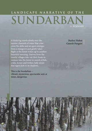
L A N D S C A P E N A R R A T I V E O F T H E
SUNDARBAN
A SUMMARY
Bushra Nishat
Ganesh Pangare
A thick fog crawls slowly over the
narrow channels of water that criss-
cross the delta and an egret emerges
from a mangrove and gently takes
flight as the forest wakes up to another
beautiful morning. Natives from the
nearby villages take out their boats to
venture into the forest in search of fish,
crabs, honey and timber, fully aware
that tigers lurk in its shadows.
This is the Sundarban –
vibrant, mysterious, spectacular and, at
times, dangerous.
Photo credit: Ganesh Pangare
2. 2
Famous for being one of the last
remaining natural habitats of
the majestic Bengal tiger and the
eponymous sundari tree (a dominant
mangrove species in the region),
the Sundarban spreads over an
area of about 10,200 km2
shared
between India and Bangladesh. It is
a unique ecosystem that supports a
huge assortment of plant and animal
species and is sustained by a complex
interaction between multifarious
geographical and ecological factors.
Apart from its rich biodiversity, the
Sundarban is significant also because it
provides livelihood to some of the most
economically vulnerable people in the
world, constituting nearly 0.1 per cent
of the global population.
The shared Sundarban region is
considered to be one of the seven
most globally important wetlands
of the world (WWF, 2017). The
Sundarban National Park in India
and the Sundarban Reserve Forest in
Bangladesh have been declared World
Heritage Sites by UNESCO has also
beenlistedasaWetlandofInternational
Importance in the Ramsar Convention.
The Sundarban, geographically contiguous,
but administratively split into two
regions because of the international
boundary, has been seen as two
separate ecosystems instead of one
since 1947. However, this shared
region offers India and Bangladesh a
great opportunity for collaborative
planning and action.
At present, there is very little attempt
to understand the Sundarban in its
entirety, as one landscape or one
region, and available literature focuses
on only one side of the Sundarban
(Dipu and Ahmed, 2013; Sarker,
2010). This narrative, for the first time,
tries to bridge the knowledge gap by
collating data from both countries in
order to facilitate the development
of a collaborative action plan for the
Sundarban region. This narrative
defines the Sundarban region as the
Sundarban Reserve Forest (SRF)
and the Ecologically Critical Area
(ECA) adjacent to the Sundarban in
Bangladesh and Sundarban Biosphere
Reserve (SBR) in West Bengal,
India. Thus defined, the Sundarban
represents not only the uninhabited
mangrove forests but also the bordering
areas that are home to people who are
directly dependent on the forest for
their lives and livelihood.
Why this narrative?
To bridge the
knowledge gap by
collating data from
both countries in
order to facilitate
the development
of a collaborative
action plan for the
Sundarban.
The objectives of this narrative are to:
g Create a multilayered and holistic
understanding of the Sundarban
to initiate planning activities that
transcend political boundaries and
multiple scales.
g Align and analyse information of
ecological, socio-economic and
cultural variables of the Sundarban
from different sources and records
to support joint understanding of
the Sundarban.
g Synthesize current literature to
identify effective management
approaches and practices of the past.
g Identify the gaps in learning,
knowledge, data and information on
the Sundarban.
3. 3
The Sundarban landscape is dominated by deltaic
formations that include a network of water channels
(where freshwater rivers and canals mix with tidal
seawater channels), salt marshes, tidal sandbars and
islands. The tides play an important role in sculpting
the physical features of the land and the landscape
keeps changing from high to low tide. However, the
Sundarban landscape is not shaped by one factor alone
but by the complex interaction of the coastal system
that includes tides, currents, sediments and organic
matter. The Sundarban is ever-changing and keeps
evolving through the bio-tidal processes of accretion
and erosion. The natural resources management of the
Sundarban in both countries focuses on protection
of plants and wildlife rather than conservation of
the habitat and overlooks the spatial progressions
and interlinkages of the entire ecosystem. These
interlinkages between a wide variety of factors that
affect the ecosystem and each other, some of which
exist outside the physical boundary of the forest,
hinder accurate analysis and as such result in slow
or insignificant progress in planning and resources
management. Thus, the management of the Sundarban
will need to expand its spatial as well as subject-matter
boundaries if it is to capture such interrelationships.
Most of the present-day Sundarban region was formed
during the last 5000 years by bio-tidal processes and
marine and atmospheric agencies. Erosion of estuary
margins and changes in the sea face happens
simultaneously with deposition of silt and rise of
riverbeds. This shapes the land masses (like beaches,
dunes, swamps and so on) in the area and causes water
channels to change their courses from time to time.
These changes can be sped up by land-reclamation
efforts and sea level rise due to climate change. Planning
for this region needs to account for man-made as
well as natural changes and strike a balance between
conservation of nature and the needs of the people.
Around 30 percent of the Sundarban is covered
by water and the unique ecosystem of this mangrove
forest is shaped by rivers, canals and tidal flows. The
rivers in the region are fed by the distributaries of
the Ganga river system. The freshwater inflow from
these rivers helps mitigate the salinity brought in by
the tidal seawater of the Bay of Bengal. However, in
recent decades the salinity has been rising in the area
and moving further inland due to reduced flow of
fresh water because of man-made diversions and dams
as well as rise in sea levels.
The fragile ecosystem of the Sundarban and the
communities living in and around the Sundarban are
vulnerable to tropical cyclones, storm surges, erosion,
flood, drought, frequent inundation by high tide
causing loss and disruption to lives and livelihood and
often irreparable or long-term damage to the ecosystem.
However, studies show that mangroves have the ability
to cope with such hazards and, in most cases, recover
from the impacts in due course (Spalding et.al. 2014).
The Physical Landscape
The Sundarban is ever- changing and keeps evolving through the bio-
tidal processes of accretion and erosion.
4. 4
Mangroves thrive in tropical estuarine
regions where mud-rich land meets
sea. Their specialized root systems
help them survive high water stress
and fluctuations in temperature and
salinity. The delicate balance of fresh
water and seawater in the Sundarban
has helped create a unique ecosystem
that is suitable for mangroves.
However, increasing salinity in the
region is bringing about changes in
vegetation –for example, trees like the
tall sundari mangrove and golpata/nipa
palm, which were abundant fifty years
ago, are now on the decline (Islam et
al., 2014). Salinity increase has affected
the species combination and regular
succession patterns and dwarf species
are gradually replacing the taller trees.
The full impact of this on wildlife has,
however, not been assessed.
The Sundarban is home to a number
of mangrove species like sundari
(Heritiera fomes), gewa (Excoecaria
agallocha), goran (Ceriops decandra)
and keora (Sonneratia apetala). Sir
David Prain (1903) recorded a total of
334 species of plants in the Sundarban
and surrounding areas. However,
recent studies have revealed a decline
in diversity. In the Sundarban, three
distinct vegetation types have been
documented in relation to varying
degrees of water salinity and freshwater
flow, and the vegetation consists of
recurrent patches of these vegetation
types. The pattern of vegetation
succession in the Sundarban depends
on the freshwater rivers that deposit
silt, build land, and determine the
salinity level.
The diverse array of plants,
invertebrates and types of habitat in
the Sundarban support an abundant
wildlife, both terrestrial and aquatic.
The wildlife of the Sundarban has
adapted to the freshwater and saline-
waterenvironmentandtheebbandflow
of tides. These wetlands also sustain
billions of protozoans, cnidarians,
barnacles (Amphibalanus spp.), oysters
(Crassostrea spp.), lichen and other
invertebrates. These organisms support
juvenile fish, crabs, prawns, shrimps
and molluscs, which seek refuge in
the shallow intertidal reaches that
characterize the mangrove wetlands;
these in turn are food to wading
migratory and local birds, pelicans
and the endangered crocodile. As
many as 447 species of vertebrate
wildlife (amphibians, reptiles, birds
and mammals) including the Gangetic
and Irrawaddy dolphins, and the olive
ridley turtles have also been reported.
Importantly, the Sundarban is one
of the few places in the world where
the Bengal tigers still live in the wild.
The tigers are vulnerable to poaching
and revenge killing. In the villages
around the Sundarban, prevention or
resolution of tiger-human conflicts is a
major part of tiger - conservation
efforts.
The Biological Landscape
The Sundarban
serves as a breeding
and nursing
habitat for diverse
marine organisms.
Importantly, the
Sundarban is one
of the few places in
the world where the
Bengal tigers still live in
the wild.
5. 5
The conservation and management
efforts in the Sundarban are primarily
focused on protection of biodiversity
and habitat of animals and plants. Till
now, planning and strategy, in both
India and Bangladesh, do not reflect
the economic importance of the
forest for the people who live nearby.
These people are amongst the poorest
in the region and face similar poverty-
related issues on both sides of the
border. The forest is their main source
of livelihood as well as fuel, food,
medicine and building materials. For
example, in Bangladesh, the Sundarban
provides employment for over 350,000
people working as jaleys (fishermen),
bawalis (woodcutters), mouals (honey
gatherers) and shrimp fry, crab, nipa-
leaf and thatching- grass collectors
(Tamang, 1993). In India, the livelihood
of nearly 2 million people is linked with
the Sundarban, which mainly includes
fishing, crab, collection, honey and
beeswax collection and allied activities
(Singh et al. 2010).
With the moratorium on harvesting
of timber in both countries, agriculture
and fishing and shrimp fry, crab
and honey collection are the most
common ways of earning a living in
the Sundarban. In recent decades
modern livelihood opportunities like
tourism and brackish water shrimp
farming have also gained popularity.
The population, in the Sundarban
Biosphere Reserve in India has
shown a steady increase over the last
decade, while it has gone down in
the areas surrounding the Sundarban
Reserve Forest in Bangladesh. The
threat of natural hazards coupled with
the unpredictability of land and water
is a constant source of anxiety and
vulnerability for the settlers around
the Sundarban. The fragile ecology of
the region, threat of natural disasters,
environmental degradation, drinking
water scarcity due to increased
salinity and inadequate infrastructure
development in the peripheral areas
limiting livelihood options are the
main reason for this out migration.
Management and Conservation
Practices Living in close contact
with raw nature, the people of
the Sundarban region have great
respect for it, and their traditional
practices, religious beliefs, rituals,
folklore and arts and crafts promote
conservation and living in harmony
with nature. Scientific management of
the Sundarban mangrove forest was
initiated during the British era when
the first call to preserve the forests
was made in 1862 ( Choudhury and
Ahmed, 1994). Faced with dwindling
forest produce, the colonial rulers
declared some parts of the Sundarban
as reserved forest in 1875–76 under
the Forest Act (1855), and resource
exploitation was brought under
government control with a system of
permits. Despite this, by 1930s, the
standing stocks of other trees were on
the decline due to unregulated felling
and, thus, the Curtis plan, which was
based on detailed scientific inventory,
came into force in 1931. The Curtis
plan remains the last coordinated
assessment of the entire Sundarban
as one forest. Thereafter the relevant
laws, policies and management plans
have been Sundarban, focused only on
their side of the timber in both forest.
Issues and Shared Challenges The
Sundarban symbolizes a world of
human earning a living in the poverty
and vulnerability surrounded by
natural
The Socio-Economic
Landscape
With the moratorium
on harvesting of
timber in both
countries, agriculture
and fishing are the
most common ways of
earning a living in the
Sundarban region.
6. 6
richness.In Bangladesh and India–despite
national and international concern,
political support and significant resource
flows – a combination of exposure to
disasters and natural stresses, increasing
population pressure, unregulated drives
towards commercialization of natural
products and insufficient institutional
coordination and capacity has led
to inadequate management of the
Sundarban and continuous degradation
of forest resources. While both countries
face similar challenges with regard to
sustainable resource management in the
shared region, political and administrative
boundaries have impacted their
effectiveness in dealing with these issues.
Around 7.5 million1
people are directly
dependent on the Sundarban and suffer
from several and similar dimensions of
poverty in the two countries. The average
per capita income in the Indian part is about
USD 0.5 per day while the corresponding
figure for the Bangladesh part is about USD
0.9 per day. Common factors highlighting
this extreme poverty include poor health
conditions, relatively low education
levels, limited employment opportunities,
inadequate infrastructure and very high
risk of persistent cyclones, floods and
embankment failures.
The Sundarban is an active delta region and
the numerous islands are still being formed
and reformed by natural processes. While
mangroves help in soil conservation, sea
level rise and tidal hydraulics have caused
erosion in many of the islands. Hence,
it needs to be included in planning and
management of the region. Both countries
are also vulnerable to the effects of climate
change like cyclones, fluctuations in water
salinity and flooding. Climate change and
sea level rise also affect agriculture and can
be devastating for the fragile Sundarban
ecosystem.
The management policies in both the
countries reflect their individual priorities,
and the political borders create the
perception that the two sides of the
Sundarban are two separate regions. In
Bangladesh, the Sundarban Reserve Forest
(SRF) is managed by the Forest Department.
Their primary focus is conservation of
biodiversity. As per the provisions of
Environmental Conservation Act, 1995,
the 10-km wide band surrounding the
northern and eastern boundaries of the
SRF, was declared ecologically critical area
(ECA) with the main objective of providing
protection to the SRF and conservation of
its biodiversity. However, other than a few
uncoordinated activities by government
and non-government agencies, no real
initiative has been taken to manage and
develop the ECA area so far. In India, the
degree of protection across the Sundarban
Biosphere Reserve varies greatly. While
the Project Tiger is federally managed, the
national park and the wildlife sanctuaries
are under the forest department of the state
of West Bengal, who have varying degrees
of control in different parts. The presence of
numerous governmental organizations with
overlapping authorities and responsibilities
gives rise to duplication of efforts, especially
in terms of socioeconomic development,
and monitoring of outcomes is limited.
As regards data collection, three types
of data are crucially required – forest
inventory, wildlife census and survey,
and hydro-meteorological data. While
the government agencies in India and
Bangladesh periodically collect these and
other data, they lack a coordinated approach
that can lead to a holistic understanding
for better management of the Sundarban.
Non-governmental actors, like researchers,
scientists and journalists, add to the
information database through their studies
but their efforts are temporary and limited.
After 1930 there has been no attempt to
scientifically assess the Sundarban as a
whole.
This joint landscape narrative attempts to
address these issues by combining data
from a wide range of sources in order to
support the development of a coordinated
action plan.
In Bangladesh
and India,
around 7.5
million people
are directly
dependent on
the Sundarban.
They suffer
from many
poverty- related
problems like
poor health, low
education, limited
employment
opportunities
and poor access
to drinking water,
sanitation and
electricity.
1. Nearly 5 million in West Bengal, India, live in the buffer zone of Sundarban Biosphere Reserve and analyses from different studies (Hussain, 2014), show that
the population, which according to BBS (2010) is 2.5 million, residing in a 20 km wide radius surrounding the periphery is directly dependent on the Sundarban
in Bangladesh.
7. 7
In 2011, India and Bangladesh signed
a memorandum of understanding for
bilateral cooperation on conservation
of the Sundarban and a protocol on
the protection of tigers. Under these
two mutual agreements a number of
strategic actions have been proposed to
be undertaken in collaboration, such as
joint research and monitoring, sharing
of relevant information and technical
knowledge (e.g., on tiger–human
conflict) between the concerned officials
of the two countries and execution of
patrolling along the borders to prevent
poachingandillegaltrade.However,there
is scope for more collaborative activities
that the two countries can focus on and
many areas in which the two countries
can cooperate. By recognizing common
grounds and differences, specific needs
and priorities can be identified.
India and Bangladesh can work together
on natural resources management to
improve biodiversity conservation
outcomes. Restoration and recovery
programmes and better recognition of
the full value of forests can help increase
profitability, which could become an
incentive for investment in the forests.
Preventing or resolving human–wildlife
conflicts and providing incentives to
forest officials and communities can help
in protecting wildlife. Both countries
can start community forestry that seeks
to ensure both social interests and
sustainable management of the forests
and offers an integrated package of
benefits. Sharing relevant data on plant
and animal life and enhancing current
knowledge base will also be helpful. In
this, developments in technology can
play a significant role. Cultural and
media exchanges are also important for
improving bilateral relations as well as
attracting new ideas and perspectives.
India and Bangladesh can also work
togethertoimprovedisastermanagement
through technical cooperation, capacity
development and development of
regional mechanisms and capacities
for early warning among other things.
Stronger economic growth and poverty
reduction are critical to sustainable
management of the Sundarban. All
plans with regard to conservation and
management of the Sundarban must
include the people of the region as part
of the solution. Both countries recognize
the potential of green economy to boost
economic growth and meet conservation
goals simultaneously. They can work
together on this. Public services also
need to be strengthened, and joint
planning with a unifying agenda
underpinned by goals and targets, and
exchange of experiences can be the mode
of cooperation.
Fisheries and aquaculture can be
improved by measures such as joint fish
stock assessment, helping local fishermen
improve productivity and profitability,
identifying more fish sanctuaries and
fostering backyard hatcheries to reduce
dependence on wild shrimp fry.
The two countries also need to focus
more on marine resource conservation
through ocean research and marine
protected areas. Integrating mangroves
conservation in the marine resources
conservation can be an important
approach for both countries. Joint
courses and curriculum development
focusing on applied /advance researches
such as marine bio- technology, marine
fertilization and habitat modelling can be
introduced.
India and Bangladesh have agreed
to work together on climate change
adaptation and mitigation. Additional
activities they can focus on are, among
other things, conducting medium- and
long-range planning that incorporates
climate change and variability, creating
clear and integrated regional guidelines
for REDD+ (Reducing emissions from
deforestation and forest degradation
and the role of conservation, sustainable
management of forests and enhancement
of forest carbon stocks in developing
countries) community forestry, and
studying the capacity of mangroves to act
as carbon sinks.
There is scope for
more collaborative
activities that the
two countries can
focus on and many
areas in which
the two countries
can co-operate.
By recognizing
common grounds
and differences,
specific needs and
priorities can be
identified.
Emerging Opportunities
for Coordinated and
Concurrent Activities
8. 8
The Way Forward
While it is obvious that the Sundarban has to be considered
as one ecosystem, the issue really is how to make this
collaborative action workable. Bangladesh and India are
separate countries and, therefore, any interaction between
them needs the involvement of and clearance from their
respective governments. However, it is the state government
of West Bengal which is directly concerned with the
Sundarban, so its involvement is crucial. Finally, the policies
of governance and the problems are different on the two sides
of the border. This makes it more complex.
Regional platforms need to be established and developed to
work alongside other regional platforms across sectors and
with the drivers of change in different rivers and basins. With
multiple treaties signed between the two nations, the shared
Sundarban region has a possibility where it is developed
sustainably and managed as one ecosystem. In recent years,
several joint bodies have been set up of the governments of
India and Bangladesh for the protection of the Sundarban.
The current level of cooperation is not enough to keep up
with the dynamics of climate change and emerging socio-
economic needs of the people.
Consensus building in joint ecology management and
conservation efforts starts with national interests, including
economic development, security and concerns and needs of
the local population. Hence, it requires trust and political
will, platforms for dialogue and transparency, knowledge
and information, capacity and tools for integration of
competing demands and identification of mutual benefits.
Successful management of the Sundarban will require
crafting of effective institutions at multiple levels in order to
provide incentives and disincentives. More importantly, the
institutions need to be truly representative, processes that
support interaction with stakeholders must also be included.
Agreements will work on the ground only if they involve
stakeholders and have their support and take into account
local politics. In order to catalyse and mobilize regional
platforms, it is necessary to include them in national agendas
and international dialogues.
Successful management of the Sundarban will require crafting of effective
institutions at multiple levels in order to provide incentives and disincentives.
g Dipu, S., and Ahmed, F. 2013. Sundarban: Rediscovering Sundarban; The Mangrove Beauty of Bangladesh. Edited by Reza Khan. Dhaka:
Nymphea Publication.
g Choudhury, R.A., and Ahmed, I. 1994. “History of Forest Management”. In Bangladesh, vol. 2 of Mangroves of the Sundarbans, edited by Z.
Husain and G. Acharya, 155–179. Bangkok: International Union for Conservation of Nature.
g Islam S, Rahman M and Chakma S (2014). Plant Diversity and Forest Structure of the Three Protected Areas (Wildlife Sanctuaries) of Bangladesh
Sundarbans: Current Status and Management Strategies. In: Mangrove Ecosystems of Asia, Faridah-Hanum et al. (eds.) Springer, New York, 127-
152.
g Prain, D. 1903. Bengal Plants. Volume 2. Calcutta: West, Newman. https://archive.org/details/in.ernet.dli.2015.47849.
g Sarkar, S.C. 2010. The Sundarbans: Folk Deities, Monsters and Mortals. New Delhi: Social Science Press.
g Singh, A., Bhattacharya, P., Vyas, P. and Roy, P. 2010. Contribution of NTFPs in the livelihoods of mangrove forest dwellers of Sundarban. Journal
of Human Ecology 29(3); 191-200.
g Spalding, M., McIvor, A., Tonneijck, F.H., Tol, S., and van Eijk, P. 2014. Mangroves for Coastal Defence: Guidelines for Coastal Managers and
Policy Makers. Wageningen, Netherlands: Wetlands International; Arlington, VA, USA: The Nature Conservancy.
g Tamang, K.M. 1993. Wildlife Management Plan for the Sundarbans Reserved Forest. Report of the Food and Agriculture Organization of the
United Nations and the United Nations Development Programme project entitled Integrated Resource Development of the Sundarbans Reserved
Forest, Dhaka, Bangladesh.
g Verma, M. 2018. Benefits of Cooperation: Focus on the Sundarban. Identification and Assessment. Discussion draft for Bangladesh-India
Sundarban Region Cooperation Initiative (BISRCI) . Available at https://www.sundarbansonline.org/wp-content/uploads/2019/05/Summary_
Economic-benefits-of-cooperation_FinalReport_2019.pdf
g WWF (World Wide Fund for Nature). 2017. “Major Wetlands of the World”. World Wide Fund for Nature. http://wwf.panda.org/our_work/
water/intro/majorwetlands/.