Land cover map of Nepal.pdf
•
4 likes•149 views
This document provides information about a land cover map of Nepal created by Shishir Mahatara Chhetri. It summarizes that the map covers Nepal's 147,516 square kilometers and divides it into seven federal states and 77 districts. It then describes the main land cover types in Nepal, including different forest types, croplands, shrublands, grasslands, and bare lands. The document proceeds to define land cover and land use, and provides descriptions of nine land use categories classified in the map, such as water, trees, crops, built areas, and bare ground. It concludes by listing several applications of land cover mapping, such as for planning, disaster management, and policy development.
Report
Share
Report
Share
Download to read offline

Recommended
Sst project
The document discusses different types of natural vegetation and land use in India. It describes six main types of natural vegetation: tropical evergreen forests, tropical deciduous or monsoon forests, tropical thorn and shrub forests, desert vegetation, mangrove forests, and Himalayan vegetation. It provides details on the climate, rainfall levels, and prominent plant species found in each vegetation type. Land use involves agriculture, forestry, human settlements, and other activities.
DESERT PLANNING
This presentation offers a comprehensive overview of conservation and sustainable development in arid regions. It covers the unique characteristics of arid environments, conservation efforts in desert ecosystems, and challenges like desertification. Key topics include guidelines for planning desert areas, the impact of desertification on climate change, and models for ecological planning. Initiatives like the Desert Development Programme (DDP) and the establishment of Desert Development and Climate Resilience (DDCR) zones are discussed. The presentation emphasizes the importance of balancing economic development with environmental preservation and calls for collaborative efforts among stakeholders and policymakers.
Land,soil,water class- VIII social science
This document provides information about a social studies lesson plan for Class VIII on the topic of geography, land, soil, water, natural vegetation, and wildlife. It includes 4 learning periods that cover different objectives and activities. The objectives focus on understanding land use and distribution of population, causes of landslides and methods of soil conservation, availability and uses of water and methods of water conservation, and natural vegetation, wildlife, and their conservation.
Land, soil, water, natural vegetation
Land, soil, water, natural vegetation, and wildlife are important natural resources. Land covers 29% of the Earth's surface and is unevenly distributed worldwide due to differences in characteristics and climate. Soil is formed through weathering and influenced by parent rock and climate factors. It is degraded through processes like erosion, but conservation methods like contour farming and shelter belts can help protect it. Water is essential for life but most is saline or locked in ice sheets; only 1% is accessible as freshwater in rivers, lakes, and groundwater. Natural vegetation and wildlife exist within ecosystems and depend on each other for survival.
Ldb Permacultura_Kent dryland strategies 2
The document discusses dryland strategies for establishing vegetation in arid environments. It focuses on reducing evaporation through techniques like planting windbreaks and adding mulch to increase soil moisture and plant growth. Key strategies include establishing deep-rooted pioneer trees with irrigation, directing runoff to infiltrate soils, and harvesting water in swales and dams. The document also provides guidelines for desert housing and settlements, emphasizing passive cooling methods and water conservation.
Ldb Permacultura_Kent dryland strategies
Dryland strategies focus on reducing evaporation through increasing soil life and plant cycles. This decreases evaporation via shade, wind buffering, and mulch additions. This improves water cycling efficiency for plant establishment. Techniques include reducing wastewater, managing flood flows, and runoff. Pioneer trees need mulch and drip irrigation for wind buffering and mulch production. Summer is a slow period with heat and water stress, so fertilizers are added in winter. Desert housing requires cooling in summer and warmth in winter through features like courtyards, evaporation, and ventilation strategies.
Desert biome
This slide gives concise information about the geomorphology of deserts, the topography of desert, species interaction and desert fauna and flora
Lmy10 p geu7a.3 manage may11pp
This document discusses various methods for managing desertification and soil erosion in different regions. It describes how farmers in the Sahel region of Africa have successfully reduced desertification by planting trees that stabilize soil and increase moisture retention. It also provides examples from the US and Australia of using controlled livestock grazing to mimic the effects of historical large herbivores in reducing unwanted vegetation and increasing soil organic matter. Afforestation efforts in Niger have enabled farming to resume on lands that had become barren due to overgrazing and deforestation. Managing irrigation and installing check dams in Australian orchards has reduced erosion and improved soil quality and production.
Wasteland classification
Wastelands refer to degraded lands that are currently underutilized, and are deteriorating for lack of appropriate soil & water management or on account of natural causes.
Wastelands develop naturally or due to influence of environment, chemical and physical properties of the soil or management constraints.
The classification scheme adopted for monitoring of wasteland on 1:50,000 scale.
On the other hand, the Wasteland Development Board and some other institutions have considered all those categories of land as wastelands which are not under the use of forest pasture and cultivation.
From the utilization point of view, wastelands are classified as forest wasteland and non-forest wasteland, cultivated wasteland and non-cultivated wasteland .
In the wasteland classification scheme followed by Department of Land Resources, Ministry of Rural Development and National Remote Sensing Centre, Indian Space Research Organization, Department of Space, Govt. of India during 2003 for Wastelands Atlas of India 2005, 28 categories of wastelands were identified which have been now brought down to 23 categories in the wasteland classification scheme followed in 2006 for the preparation of Wastelands Atlas of India 2010.
Following thirteen categories of lands were classified under wastelands in India.
Gullied and/or ravenous land
Upland with or without scrub.
Water logged and marshy land.
Land affected by salinity/alkalinity-coastal /inland.
Shifting cultivation area.
Underutilized /degraded notified forest land.
Degraded pastures/grazing land.
Sands-deserted/coastal
Mining-industrial wastelands.
Barren rocky/stony waste/ sheet rocky area.
Steep sloping areas.
Snow covered land/or glacial area.
Degraded land under plantation crops
desertification (1).pdf
Desertification is caused by both human and environmental factors and is a significant problem globally. The document discusses several types and causes of desertification including drought, overgrazing, overcultivation, and removal of trees. It also outlines various countermeasures that can be taken to address desertification such as reforestation, soil fixation, contour trenching, and managed grazing. However, large-scale afforestation efforts in China have failed to solve desertification due to the arid climate not being suitable for tree growth and survival with low rainfall under 500mm annually.
DESERTIFICATION
Three main points:
1. Desertification is a type of land degradation where dry regions become more arid, losing vegetation and wildlife. It is caused by factors like drought, overgrazing, overcultivation, and removal of trees.
2. Categories of desertification range from light to very severe based on damage to vegetation and soil. Countermeasures include reforestation, soil fixation, contour trenching, and managed grazing.
3. Large-scale afforestation efforts in China have failed to solve desertification due to unsuitable climate with low rainfall, as the natural vegetation is grassland or desert in semiarid and arid regions with 50-500mm of rain. Previous attempts at aff
Ch 2 Land, Soil, Water, Natural Vegetation and Wildlife Resources 1.pptx
This document is a lesson plan on land, soil, water, natural vegetation, and wildlife resources for an 8th grade geography class. It covers key topics like the different types of land and soil, factors that influence soil formation, conservation of land and soil resources, water as a vital resource and issues with its availability, and the importance of natural vegetation and threats to wildlife. The teacher provides definitions, facts, and activities for students to help them understand these important natural resources and environmental concepts.
Major types of ecosystem
This document discusses the major types of ecosystems. It defines terrestrial ecosystems as land ecosystems like grasslands, deserts, and forests. Aquatic ecosystems are divided into freshwater ecosystems found in lakes, rivers, and wetlands, and marine ecosystems found in oceans. Some key points made are:
- Terrestrial ecosystems are differentiated based on dominant plant life and climate factors. Examples given are deserts, grasslands, and forests.
- Aquatic ecosystems include freshwater habitats like lakes and rivers, as well as marine habitats like coral reefs and coastal wetlands.
- Ecosystems maintain a balance and ecological succession between living and non-living elements. Human activities can disrupt this balance, threatening wildlife conservation
Unit - II - Eco Systems.ppt
An ecosystem is a biological community of interacting organisms and their physical environment. This document discusses different types of ecosystems including terrestrial and aquatic ecosystems. It provides details about forest ecosystems, describing their key components such as producers, consumers, decomposers and abiotic factors. It also discusses grassland ecosystems and their characteristics.
Afforestation on sand dunes manoj ranabhat
This document is a term paper on afforestation of sand dunes presented by Manoj Ranabhat. It discusses the concept of afforestation and characteristics of sand dunes. Some key points include that afforestation aims to establish forests in areas without vegetation through artificial means. Sand dunes are classified by size and shift due to wind and lack of vegetation. Successful afforestation of sand dunes requires selecting drought-resistant tree species that can stabilize the dunes, conserve moisture, and regenerate naturally. Common species planted include Acacia tortilis and Prosopis chilensis. The paper also discusses techniques for planting, maintenance, and protection of afforested areas.
Desertification 2
Desertification is a significant global problem caused by both human and environmental factors. It involves dry land regions becoming increasingly arid and losing vegetation and wildlife. There are various types and causes of desertification including drought, overgrazing, overcultivation, and removal of trees. Countermeasures aim to prevent further desertification through reforestation, soil fixation, contour trenching, farmer-managed natural regeneration, and managed grazing. Past large-scale afforestation efforts in China's dry northwest have failed due to unsuitable climate conditions of low rainfall, though some localized successes have occurred near available water sources.
Land, soil, water, natural vegetation and wildlife resources
Land, soil, water, natural vegetation and wildlife resourcesKendriya Vidyalaya No. 1, Bikaner, Rajasthan
This is a PowerPoint Presentation based on Chapter-2, NCERT Geography book (Resources and Development) of Class 8. It consists of descriptions, importance and many characteristics related to land, landslides, soil, weathering, methods of soil conservation, water, natural vegetation, wildlife, ecosystem and much more.Distribution of wasteland and problem soils
This ppt is about the distribution of wasteland and problem soils. Those lands are wastelands which are ecologically unstable,
whose topsoil has nearly been completely lost, and
which have developed toxicity in the root zones or growth of most plants, both annual crops and trees”.
Naturalvegetation
1. Land, soil, water, natural vegetation, and wildlife are important natural resources. Soil provides nutrients for plants but is vulnerable to erosion from deforestation, overgrazing, and weathering.
2. Water is necessary for life but human activities like agriculture, industry, and urbanization are straining water supplies. Conservation methods like rainwater harvesting and drip irrigation can help manage water resources.
3. Natural vegetation and wildlife exist in delicate ecosystems and are threatened by habitat loss, pollution, and hunting. Protected areas and awareness programs aim to preserve biodiversity.
national vegetation
This document discusses different types of natural vegetation regions around the world. It describes forests, grasslands, tundra, deserts and ice sheets as the main vegetation regions. Each region is characterized by distinct plant communities that are determined by climate factors like temperature and precipitation. The document provides examples of different forest and tundra types. It also explains how lack of precipitation defines deserts and how ice sheets have no vegetation. Latitude and altitude are described as influencing regional climates and associated vegetation distribution.
MAJOR VEGETATION TYPES OF THE WORLD.pptx
Major types of vegetation all over the world includes common vegetation like forest vegetation and its types, desert vegetation, aquatic vegetation and grassland vegetaton with their respectives types. It is explained with the help of world so that it will clear the reader's concept and easy to understand. A comparision between major four types of vegetation like natural and artificial vegetation, primary and secondary vegetation also discussed here. It mainly discussed the vegetation of tropical region, temperate region and boreal region of the Earth.
The Status of Soils resources, Needs and Priorities for sustainable managemen...
http://www.fao.org/globalsoilpartnership
This presentation was made during the regional conference on the West and Central Africa soil partnership that took place in Agra, Ghana 4-6 April 2013. This presentation was made by Isaurinda Baptista, and it presents the priorities and needs for SSM in Cape Verde.
©FAO: http://www.fao.org
Effect of Precipatation on Distribution of Plants.pptx
Useful for the students who wants to study this topic & enhances the knowledge for a specific topic.
PRECIPITATION:
is any product of the condensation of atmospheric water that falls under gravity from clouds.
The main forms of precipitation include drizzle, rain, sleet, snow, ice pellets, graupel and hail. Precipitation occurs when a portion of the atmosphere becomes saturated with water vapor (reaching 100% relative humidity), so that the water condenses and "precipitates". Thus, fog and mist are not precipitation but suspensions, because the water vapor does not condense sufficiently to precipitate.
Two processes, possibly acting together, can lead to air becoming saturated: cooling the air or adding water vapor to the air.
REASON FOR CHANGE IN PRECIPITATION:
There are many reasons for changes in precipitation. The leading cause is a change in temperature. Many scientists believe an increase in temperature could lead to a more intense water cycle. The rates of evaporation from soils and water, as well as transpiration from plants, could increase. The amount of precipitation could also increase.
Predicted changes in the water cycle differ according to the region of the planet being examined. Many scientists believe rates of evaporation will be greater than precipitation in the middle latitudes such as the United States. This could result in drier summers in these regions.
Of course, predicted changes in the water cycle also differ according to the climate.
EFFECT OF PRECIPITATION ON PLANTS:
Precipitation, especially rain, has a dramatic effect on plants distribution. All plants need at least some water to survive, therefore rain (being the most effective means of watering) is important to agriculture. While a regular rain pattern is usually vital to healthy plants, too much or too little rainfall can be harmful, even devastating to crops. Drought can kill crops and increase erosion, while overly wet weather can cause harmful fungus growth. Plants need varying amounts of rainfall to survive. For example, certain cacti require small amounts of water, while tropical plants may need up to hundreds of inches of rain per year to survive.
In areas with wet and dry seasons, soil nutrients diminish and erosion increases during the wet season.
DISTRIBUTION OF PLANTS IN DIFFERENT BIOMES:
The geographical distribution (and productivity) of the plants in the various biomes is controlled primarily by the climatic variables precipitation and temperature.
There are 8 major terrestrial biomes
>Tropical Rain Forest
>Tropical Savanna
> Deserts
>Grass Lands
> Chaparral
> Temperate Deciduous Forests
> Temperate Boreal Forests
> Artic And Alpine Tundra
Each biome plants have different adaptation to survive in that environment.
Tundra means marshy plain. The geographical distribution of the tundra biome is largely poleward of 60° North latitude.
The tundra biome is characterized by an absence of trees, the presence of dwarf plants
8th Std 2. Land,Soil, Water, Natural Vegetation and Wildlife Resources.
8th Std Social Science - Geography- Chapter 2. Land,Soil, Water, Natural Vegetation and Wildlife Resources.
Land is among the most important natural resources.
It covers only about thirty per cent of the total area of the earth’s surface and all parts of this small percentage are not habitable.
The uneven distribution of population in different parts of the world is mainly due to varied characteristics of land and climate.
The rugged topography, steep slopes of the mountains, low-lying areas susceptible to water logging, desert areas, thick forested areas are normally sparsely populated or uninhabited. Plains and river valleys offer suitable land for agriculture. Hence, these are the densely populated areas of the world.
State of hydrogeological risks in north western rwanda
This document summarizes a study on hydrogeological risks in northwestern Rwanda. The researchers conducted field studies and interviews in five districts to identify factors contributing to landslides and flooding. They found that steep slopes, unstable soils, heavy rainfall, deforestation, and dense population all increase risks. Specific at-risk sites discussed include landslides in Busengo and Gatokoro caused by soil saturation and slope instability, as well as frequent flooding in Bigogwe and Mugogo due to heavy runoff in clay soils and deforested areas. The researchers conclude that sustainable land use practices including afforestation, terracing, and controlled settlement are needed to reduce hydrogeological risks in the region.
hoarec_somalia_vision_v6
The document outlines a landscape vision and strategic plan for the Maroodi Jeex Landscape in Somaliland. It describes the opportunities and challenges identified through a participatory workshop with community members and stakeholders. The vision is for high agriculture and livestock production with sustainable natural resource use. Key opportunities include natural resource management, food security, and alternative energy. The plan recommends land use and "3R" (recharge, retention, reuse) water conservation measures tailored to different zones. Implementing these interventions could help address water scarcity and erosion while generating income and improving livelihoods.
Landuse in India
Land is a basic natural resource, significantly contributing to a nation’s economy. Balances the Ecological and environmental factors to sustain all life. Economic resource-has a value as property. Most of the human activities are on lands. Land supports agriculture, transport, urbanization, etc. Encompasses all other natural resources, like water, oil, rocks, plants, animals and minerals. Land is a valuable natural resource utilized for cultivation of crops, settlements of population, creation of Dams and reservoirs, development of industries and maintaining forests and the Wildlife. India has divers range of landforms. They vary from the rainforest of Kerala in the south to the alpine pastures of Ladakh hills in the north, from the deserts of Rajasthan in the west to the evergreen forests in the north-east. Any kind of permanent or cyclic intervention of a land is called as landuse. It is the surface utilization of a vacant land or a developed land for a clear purpose, at a given time.
9th forestry and natural resources
This document discusses natural resources and their management. It defines natural resources as things that can be used to perform useful functions, categorizing them as non-exhaustible, renewable, or exhaustible. Soil and water are identified as exhaustible resources that are foundations of life. The document outlines best practices for soil and water conservation, including mulching, no-till farming, and terracing. It also discusses the importance of forestry for providing wood, habitat, air/water filtration, recreation, and more. Major wildlife species in Arkansas and recreational uses of natural resources are listed.
一比一原版美国贝翰文大学毕业证(BU学位证)如何办理
原件一模一样【微信:WP101A】【美国贝翰文大学毕业证(BU学位证)成绩单】【微信:WP101A】(留信学历认证永久存档查询)采用学校原版纸张、特殊工艺完全按照原版一比一制作(包括:隐形水印,阴影底纹,钢印LOGO烫金烫银,LOGO烫金烫银复合重叠,文字图案浮雕,激光镭射,紫外荧光,温感,复印防伪)行业标杆!精益求精,诚心合作,真诚制作!多年品质 ,按需精细制作,24小时接单,全套进口原装设备,十五年致力于帮助留学生解决难题,业务范围有加拿大、英国、澳洲、韩国、美国、新加坡,新西兰等学历材料,包您满意。
【业务选择办理准则】
一、工作未确定,回国需先给父母、亲戚朋友看下文凭的情况,办理一份就读学校的毕业证【微信:WP101A】文凭即可
二、回国进私企、外企、自己做生意的情况,这些单位是不查询毕业证真伪的,而且国内没有渠道去查询国外文凭的真假,也不需要提供真实教育部认证。鉴于此,办理一份毕业证【微信:WP101A】即可
三、进国企,银行,事业单位,考公务员等等,这些单位是必需要提供真实教育部认证的,办理教育部认证所需资料众多且烦琐,所有材料您都必须提供原件,我们凭借丰富的经验,快捷的绿色通道帮您快速整合材料,让您少走弯路。
留信网认证的作用:
1:该专业认证可证明留学生真实身份【微信:WP101A】
2:同时对留学生所学专业登记给予评定
3:国家专业人才认证中心颁发入库证书
4:这个认证书并且可以归档倒地方
5:凡事获得留信网入网的信息将会逐步更新到个人身份内,将在公安局网内查询个人身份证信息后,同步读取人才网入库信息
6:个人职称评审加20分
7:个人信誉贷款加10分
8:在国家人才网主办的国家网络招聘大会中纳入资料,供国家高端企业选择人才
→ 【关于价格问题(保证一手价格)
我们所定的价格是非常合理的,而且我们现在做得单子大多数都是代理和回头客户介绍的所以一般现在有新的单子 我给客户的都是第一手的代理价格,因为我想坦诚对待大家 不想跟大家在价格方面浪费时间
对于老客户或者被老客户介绍过来的朋友,我们都会适当给一些优惠。
选择实体注册公司办理,更放心,更安全!我们的承诺:可来公司面谈,可签订合同,会陪同客户一起到教育部认证窗口递交认证材料,客户在教育部官方认证查询网站查询到认证通过结果后付款,不成功不收费!
办理美国贝翰文大学毕业证(BU学位证)学位证【微信:WP101A 】外观非常精致,由特殊纸质材料制成,上面印有校徽、校名、毕业生姓名、专业等信息。
办理美国贝翰文大学毕业证(BU学位证)学位证【微信:WP101A 】格式相对统一,各专业都有相应的模板。通常包括以下部分:
校徽:象征着学校的荣誉和传承。
校名:学校英文全称
授予学位:本部分将注明获得的具体学位名称。
毕业生姓名:这是最重要的信息之一,标志着该证书是由特定人员获得的。
颁发日期:这是毕业正式生效的时间,也代表着毕业生学业的结束。
其他信息:根据不同的专业和学位,可能会有一些特定的信息或章节。
办理美国贝翰文大学毕业证(BU学位证)学位证【微信:WP101A 】价值很高,需要妥善保管。一般来说,应放置在安全、干燥、防潮的地方,避免长时间暴露在阳光下。如需使用,最好使用复印件而不是原件,以免丢失。
综上所述,办理美国贝翰文大学毕业证(BU学位证)学位证【微信:WP101A 】是证明身份和学历的高价值文件。外观简单庄重,格式统一,包括重要的个人信息和发布日期。对持有人来说,妥善保管是非常重要的。
More Related Content
Similar to Land cover map of Nepal.pdf
Wasteland classification
Wastelands refer to degraded lands that are currently underutilized, and are deteriorating for lack of appropriate soil & water management or on account of natural causes.
Wastelands develop naturally or due to influence of environment, chemical and physical properties of the soil or management constraints.
The classification scheme adopted for monitoring of wasteland on 1:50,000 scale.
On the other hand, the Wasteland Development Board and some other institutions have considered all those categories of land as wastelands which are not under the use of forest pasture and cultivation.
From the utilization point of view, wastelands are classified as forest wasteland and non-forest wasteland, cultivated wasteland and non-cultivated wasteland .
In the wasteland classification scheme followed by Department of Land Resources, Ministry of Rural Development and National Remote Sensing Centre, Indian Space Research Organization, Department of Space, Govt. of India during 2003 for Wastelands Atlas of India 2005, 28 categories of wastelands were identified which have been now brought down to 23 categories in the wasteland classification scheme followed in 2006 for the preparation of Wastelands Atlas of India 2010.
Following thirteen categories of lands were classified under wastelands in India.
Gullied and/or ravenous land
Upland with or without scrub.
Water logged and marshy land.
Land affected by salinity/alkalinity-coastal /inland.
Shifting cultivation area.
Underutilized /degraded notified forest land.
Degraded pastures/grazing land.
Sands-deserted/coastal
Mining-industrial wastelands.
Barren rocky/stony waste/ sheet rocky area.
Steep sloping areas.
Snow covered land/or glacial area.
Degraded land under plantation crops
desertification (1).pdf
Desertification is caused by both human and environmental factors and is a significant problem globally. The document discusses several types and causes of desertification including drought, overgrazing, overcultivation, and removal of trees. It also outlines various countermeasures that can be taken to address desertification such as reforestation, soil fixation, contour trenching, and managed grazing. However, large-scale afforestation efforts in China have failed to solve desertification due to the arid climate not being suitable for tree growth and survival with low rainfall under 500mm annually.
DESERTIFICATION
Three main points:
1. Desertification is a type of land degradation where dry regions become more arid, losing vegetation and wildlife. It is caused by factors like drought, overgrazing, overcultivation, and removal of trees.
2. Categories of desertification range from light to very severe based on damage to vegetation and soil. Countermeasures include reforestation, soil fixation, contour trenching, and managed grazing.
3. Large-scale afforestation efforts in China have failed to solve desertification due to unsuitable climate with low rainfall, as the natural vegetation is grassland or desert in semiarid and arid regions with 50-500mm of rain. Previous attempts at aff
Ch 2 Land, Soil, Water, Natural Vegetation and Wildlife Resources 1.pptx
This document is a lesson plan on land, soil, water, natural vegetation, and wildlife resources for an 8th grade geography class. It covers key topics like the different types of land and soil, factors that influence soil formation, conservation of land and soil resources, water as a vital resource and issues with its availability, and the importance of natural vegetation and threats to wildlife. The teacher provides definitions, facts, and activities for students to help them understand these important natural resources and environmental concepts.
Major types of ecosystem
This document discusses the major types of ecosystems. It defines terrestrial ecosystems as land ecosystems like grasslands, deserts, and forests. Aquatic ecosystems are divided into freshwater ecosystems found in lakes, rivers, and wetlands, and marine ecosystems found in oceans. Some key points made are:
- Terrestrial ecosystems are differentiated based on dominant plant life and climate factors. Examples given are deserts, grasslands, and forests.
- Aquatic ecosystems include freshwater habitats like lakes and rivers, as well as marine habitats like coral reefs and coastal wetlands.
- Ecosystems maintain a balance and ecological succession between living and non-living elements. Human activities can disrupt this balance, threatening wildlife conservation
Unit - II - Eco Systems.ppt
An ecosystem is a biological community of interacting organisms and their physical environment. This document discusses different types of ecosystems including terrestrial and aquatic ecosystems. It provides details about forest ecosystems, describing their key components such as producers, consumers, decomposers and abiotic factors. It also discusses grassland ecosystems and their characteristics.
Afforestation on sand dunes manoj ranabhat
This document is a term paper on afforestation of sand dunes presented by Manoj Ranabhat. It discusses the concept of afforestation and characteristics of sand dunes. Some key points include that afforestation aims to establish forests in areas without vegetation through artificial means. Sand dunes are classified by size and shift due to wind and lack of vegetation. Successful afforestation of sand dunes requires selecting drought-resistant tree species that can stabilize the dunes, conserve moisture, and regenerate naturally. Common species planted include Acacia tortilis and Prosopis chilensis. The paper also discusses techniques for planting, maintenance, and protection of afforested areas.
Desertification 2
Desertification is a significant global problem caused by both human and environmental factors. It involves dry land regions becoming increasingly arid and losing vegetation and wildlife. There are various types and causes of desertification including drought, overgrazing, overcultivation, and removal of trees. Countermeasures aim to prevent further desertification through reforestation, soil fixation, contour trenching, farmer-managed natural regeneration, and managed grazing. Past large-scale afforestation efforts in China's dry northwest have failed due to unsuitable climate conditions of low rainfall, though some localized successes have occurred near available water sources.
Land, soil, water, natural vegetation and wildlife resources
Land, soil, water, natural vegetation and wildlife resourcesKendriya Vidyalaya No. 1, Bikaner, Rajasthan
This is a PowerPoint Presentation based on Chapter-2, NCERT Geography book (Resources and Development) of Class 8. It consists of descriptions, importance and many characteristics related to land, landslides, soil, weathering, methods of soil conservation, water, natural vegetation, wildlife, ecosystem and much more.Distribution of wasteland and problem soils
This ppt is about the distribution of wasteland and problem soils. Those lands are wastelands which are ecologically unstable,
whose topsoil has nearly been completely lost, and
which have developed toxicity in the root zones or growth of most plants, both annual crops and trees”.
Naturalvegetation
1. Land, soil, water, natural vegetation, and wildlife are important natural resources. Soil provides nutrients for plants but is vulnerable to erosion from deforestation, overgrazing, and weathering.
2. Water is necessary for life but human activities like agriculture, industry, and urbanization are straining water supplies. Conservation methods like rainwater harvesting and drip irrigation can help manage water resources.
3. Natural vegetation and wildlife exist in delicate ecosystems and are threatened by habitat loss, pollution, and hunting. Protected areas and awareness programs aim to preserve biodiversity.
national vegetation
This document discusses different types of natural vegetation regions around the world. It describes forests, grasslands, tundra, deserts and ice sheets as the main vegetation regions. Each region is characterized by distinct plant communities that are determined by climate factors like temperature and precipitation. The document provides examples of different forest and tundra types. It also explains how lack of precipitation defines deserts and how ice sheets have no vegetation. Latitude and altitude are described as influencing regional climates and associated vegetation distribution.
MAJOR VEGETATION TYPES OF THE WORLD.pptx
Major types of vegetation all over the world includes common vegetation like forest vegetation and its types, desert vegetation, aquatic vegetation and grassland vegetaton with their respectives types. It is explained with the help of world so that it will clear the reader's concept and easy to understand. A comparision between major four types of vegetation like natural and artificial vegetation, primary and secondary vegetation also discussed here. It mainly discussed the vegetation of tropical region, temperate region and boreal region of the Earth.
The Status of Soils resources, Needs and Priorities for sustainable managemen...
http://www.fao.org/globalsoilpartnership
This presentation was made during the regional conference on the West and Central Africa soil partnership that took place in Agra, Ghana 4-6 April 2013. This presentation was made by Isaurinda Baptista, and it presents the priorities and needs for SSM in Cape Verde.
©FAO: http://www.fao.org
Effect of Precipatation on Distribution of Plants.pptx
Useful for the students who wants to study this topic & enhances the knowledge for a specific topic.
PRECIPITATION:
is any product of the condensation of atmospheric water that falls under gravity from clouds.
The main forms of precipitation include drizzle, rain, sleet, snow, ice pellets, graupel and hail. Precipitation occurs when a portion of the atmosphere becomes saturated with water vapor (reaching 100% relative humidity), so that the water condenses and "precipitates". Thus, fog and mist are not precipitation but suspensions, because the water vapor does not condense sufficiently to precipitate.
Two processes, possibly acting together, can lead to air becoming saturated: cooling the air or adding water vapor to the air.
REASON FOR CHANGE IN PRECIPITATION:
There are many reasons for changes in precipitation. The leading cause is a change in temperature. Many scientists believe an increase in temperature could lead to a more intense water cycle. The rates of evaporation from soils and water, as well as transpiration from plants, could increase. The amount of precipitation could also increase.
Predicted changes in the water cycle differ according to the region of the planet being examined. Many scientists believe rates of evaporation will be greater than precipitation in the middle latitudes such as the United States. This could result in drier summers in these regions.
Of course, predicted changes in the water cycle also differ according to the climate.
EFFECT OF PRECIPITATION ON PLANTS:
Precipitation, especially rain, has a dramatic effect on plants distribution. All plants need at least some water to survive, therefore rain (being the most effective means of watering) is important to agriculture. While a regular rain pattern is usually vital to healthy plants, too much or too little rainfall can be harmful, even devastating to crops. Drought can kill crops and increase erosion, while overly wet weather can cause harmful fungus growth. Plants need varying amounts of rainfall to survive. For example, certain cacti require small amounts of water, while tropical plants may need up to hundreds of inches of rain per year to survive.
In areas with wet and dry seasons, soil nutrients diminish and erosion increases during the wet season.
DISTRIBUTION OF PLANTS IN DIFFERENT BIOMES:
The geographical distribution (and productivity) of the plants in the various biomes is controlled primarily by the climatic variables precipitation and temperature.
There are 8 major terrestrial biomes
>Tropical Rain Forest
>Tropical Savanna
> Deserts
>Grass Lands
> Chaparral
> Temperate Deciduous Forests
> Temperate Boreal Forests
> Artic And Alpine Tundra
Each biome plants have different adaptation to survive in that environment.
Tundra means marshy plain. The geographical distribution of the tundra biome is largely poleward of 60° North latitude.
The tundra biome is characterized by an absence of trees, the presence of dwarf plants
8th Std 2. Land,Soil, Water, Natural Vegetation and Wildlife Resources.
8th Std Social Science - Geography- Chapter 2. Land,Soil, Water, Natural Vegetation and Wildlife Resources.
Land is among the most important natural resources.
It covers only about thirty per cent of the total area of the earth’s surface and all parts of this small percentage are not habitable.
The uneven distribution of population in different parts of the world is mainly due to varied characteristics of land and climate.
The rugged topography, steep slopes of the mountains, low-lying areas susceptible to water logging, desert areas, thick forested areas are normally sparsely populated or uninhabited. Plains and river valleys offer suitable land for agriculture. Hence, these are the densely populated areas of the world.
State of hydrogeological risks in north western rwanda
This document summarizes a study on hydrogeological risks in northwestern Rwanda. The researchers conducted field studies and interviews in five districts to identify factors contributing to landslides and flooding. They found that steep slopes, unstable soils, heavy rainfall, deforestation, and dense population all increase risks. Specific at-risk sites discussed include landslides in Busengo and Gatokoro caused by soil saturation and slope instability, as well as frequent flooding in Bigogwe and Mugogo due to heavy runoff in clay soils and deforested areas. The researchers conclude that sustainable land use practices including afforestation, terracing, and controlled settlement are needed to reduce hydrogeological risks in the region.
hoarec_somalia_vision_v6
The document outlines a landscape vision and strategic plan for the Maroodi Jeex Landscape in Somaliland. It describes the opportunities and challenges identified through a participatory workshop with community members and stakeholders. The vision is for high agriculture and livestock production with sustainable natural resource use. Key opportunities include natural resource management, food security, and alternative energy. The plan recommends land use and "3R" (recharge, retention, reuse) water conservation measures tailored to different zones. Implementing these interventions could help address water scarcity and erosion while generating income and improving livelihoods.
Landuse in India
Land is a basic natural resource, significantly contributing to a nation’s economy. Balances the Ecological and environmental factors to sustain all life. Economic resource-has a value as property. Most of the human activities are on lands. Land supports agriculture, transport, urbanization, etc. Encompasses all other natural resources, like water, oil, rocks, plants, animals and minerals. Land is a valuable natural resource utilized for cultivation of crops, settlements of population, creation of Dams and reservoirs, development of industries and maintaining forests and the Wildlife. India has divers range of landforms. They vary from the rainforest of Kerala in the south to the alpine pastures of Ladakh hills in the north, from the deserts of Rajasthan in the west to the evergreen forests in the north-east. Any kind of permanent or cyclic intervention of a land is called as landuse. It is the surface utilization of a vacant land or a developed land for a clear purpose, at a given time.
9th forestry and natural resources
This document discusses natural resources and their management. It defines natural resources as things that can be used to perform useful functions, categorizing them as non-exhaustible, renewable, or exhaustible. Soil and water are identified as exhaustible resources that are foundations of life. The document outlines best practices for soil and water conservation, including mulching, no-till farming, and terracing. It also discusses the importance of forestry for providing wood, habitat, air/water filtration, recreation, and more. Major wildlife species in Arkansas and recreational uses of natural resources are listed.
Similar to Land cover map of Nepal.pdf (20)
Ch 2 Land, Soil, Water, Natural Vegetation and Wildlife Resources 1.pptx
Ch 2 Land, Soil, Water, Natural Vegetation and Wildlife Resources 1.pptx
Land, soil, water, natural vegetation and wildlife resources
Land, soil, water, natural vegetation and wildlife resources
The Status of Soils resources, Needs and Priorities for sustainable managemen...
The Status of Soils resources, Needs and Priorities for sustainable managemen...
Effect of Precipatation on Distribution of Plants.pptx
Effect of Precipatation on Distribution of Plants.pptx
8th Std 2. Land,Soil, Water, Natural Vegetation and Wildlife Resources.
8th Std 2. Land,Soil, Water, Natural Vegetation and Wildlife Resources.
State of hydrogeological risks in north western rwanda
State of hydrogeological risks in north western rwanda
Recently uploaded
一比一原版美国贝翰文大学毕业证(BU学位证)如何办理
原件一模一样【微信:WP101A】【美国贝翰文大学毕业证(BU学位证)成绩单】【微信:WP101A】(留信学历认证永久存档查询)采用学校原版纸张、特殊工艺完全按照原版一比一制作(包括:隐形水印,阴影底纹,钢印LOGO烫金烫银,LOGO烫金烫银复合重叠,文字图案浮雕,激光镭射,紫外荧光,温感,复印防伪)行业标杆!精益求精,诚心合作,真诚制作!多年品质 ,按需精细制作,24小时接单,全套进口原装设备,十五年致力于帮助留学生解决难题,业务范围有加拿大、英国、澳洲、韩国、美国、新加坡,新西兰等学历材料,包您满意。
【业务选择办理准则】
一、工作未确定,回国需先给父母、亲戚朋友看下文凭的情况,办理一份就读学校的毕业证【微信:WP101A】文凭即可
二、回国进私企、外企、自己做生意的情况,这些单位是不查询毕业证真伪的,而且国内没有渠道去查询国外文凭的真假,也不需要提供真实教育部认证。鉴于此,办理一份毕业证【微信:WP101A】即可
三、进国企,银行,事业单位,考公务员等等,这些单位是必需要提供真实教育部认证的,办理教育部认证所需资料众多且烦琐,所有材料您都必须提供原件,我们凭借丰富的经验,快捷的绿色通道帮您快速整合材料,让您少走弯路。
留信网认证的作用:
1:该专业认证可证明留学生真实身份【微信:WP101A】
2:同时对留学生所学专业登记给予评定
3:国家专业人才认证中心颁发入库证书
4:这个认证书并且可以归档倒地方
5:凡事获得留信网入网的信息将会逐步更新到个人身份内,将在公安局网内查询个人身份证信息后,同步读取人才网入库信息
6:个人职称评审加20分
7:个人信誉贷款加10分
8:在国家人才网主办的国家网络招聘大会中纳入资料,供国家高端企业选择人才
→ 【关于价格问题(保证一手价格)
我们所定的价格是非常合理的,而且我们现在做得单子大多数都是代理和回头客户介绍的所以一般现在有新的单子 我给客户的都是第一手的代理价格,因为我想坦诚对待大家 不想跟大家在价格方面浪费时间
对于老客户或者被老客户介绍过来的朋友,我们都会适当给一些优惠。
选择实体注册公司办理,更放心,更安全!我们的承诺:可来公司面谈,可签订合同,会陪同客户一起到教育部认证窗口递交认证材料,客户在教育部官方认证查询网站查询到认证通过结果后付款,不成功不收费!
办理美国贝翰文大学毕业证(BU学位证)学位证【微信:WP101A 】外观非常精致,由特殊纸质材料制成,上面印有校徽、校名、毕业生姓名、专业等信息。
办理美国贝翰文大学毕业证(BU学位证)学位证【微信:WP101A 】格式相对统一,各专业都有相应的模板。通常包括以下部分:
校徽:象征着学校的荣誉和传承。
校名:学校英文全称
授予学位:本部分将注明获得的具体学位名称。
毕业生姓名:这是最重要的信息之一,标志着该证书是由特定人员获得的。
颁发日期:这是毕业正式生效的时间,也代表着毕业生学业的结束。
其他信息:根据不同的专业和学位,可能会有一些特定的信息或章节。
办理美国贝翰文大学毕业证(BU学位证)学位证【微信:WP101A 】价值很高,需要妥善保管。一般来说,应放置在安全、干燥、防潮的地方,避免长时间暴露在阳光下。如需使用,最好使用复印件而不是原件,以免丢失。
综上所述,办理美国贝翰文大学毕业证(BU学位证)学位证【微信:WP101A 】是证明身份和学历的高价值文件。外观简单庄重,格式统一,包括重要的个人信息和发布日期。对持有人来说,妥善保管是非常重要的。
一比一原版西澳大学毕业证学历证书如何办理
原版定制【微信:741003700】《西澳大学毕业证学位证成绩单》【微信:741003700】成绩单 、雅思、外壳、留信学历认证永久存档查询,采用学校原版纸张、特殊工艺完全按照原版一比一制作(包括:隐形水印,阴影底纹,钢印LOGO烫金烫银,LOGO烫金烫银复合重叠,文字图案浮雕,激光镭射,紫外荧光,温感,复印防伪)行业标杆!精益求精,诚心合作,真诚制作!多年品质 ,按需精细制作,24小时接单,全套进口原装设备,十五年致力于帮助留学生解决难题,业务范围有加拿大、英国、澳洲、韩国、美国、新加坡,新西兰等学历材料,包您满意。
【业务选择办理准则】
一、工作未确定,回国需先给父母、亲戚朋友看下文凭的情况,办理一份毕业证【Q微信741003700】文凭即可
二、回国进私企、外企、自己做生意的情况,这些单位是不查询毕业证真伪的,而且国内没有渠道去查询国外文凭的真假,也不需要提供真实教育部认证。鉴于此,办理一份毕业证【Q微信741003700】即可
三、进国企,银行,事业单位,考公务员等等,这些单位是必需要提供真实教育部认证的,办理教育部认证所需资料众多且烦琐,所有材料您都必须提供原件,我们凭借丰富的经验,快捷的绿色通道帮您快速整合材料,让您少走弯路。
留信网认证的作用:
1:该专业认证可证明留学生真实身份
2:同时对留学生所学专业登记给予评定
3:国家专业人才认证中心颁发入库证书
4:这个认证书并且可以归档倒地方
5:凡事获得留信网入网的信息将会逐步更新到个人身份内,将在公安局网内查询个人身份证信息后,同步读取人才网入库信息
6:个人职称评审加20分
7:个人信誉贷款加10分
8:在国家人才网主办的国家网络招聘大会中纳入资料,供国家高端企业选择人才
【关于价格问题(保证一手价格)】
我们所定的价格是非常合理的,而且我们现在做得单子大多数都是代理和回头客户介绍的所以一般现在有新的单子 我给客户的都是第一手的代理价格,因为我想坦诚对待大家 不想跟大家在价格方面浪费时间
对于老客户或者被老客户介绍过来的朋友,我们都会适当给一些优惠。
Monitor indicators of genetic diversity from space using Earth Observation data
Genetic diversity within and among populations is essential for species persistence. While targets and indicators for genetic diversity are captured in the Kunming-Montreal Global Biodiversity Framework, assessing genetic diversity across many species at national and regional scales remains challenging. Parties to the Convention on Biological Diversity (CBD) need accessible tools for reliable and efficient monitoring at relevant scales. Here, we describe how Earth Observation satellites (EO) make essential contributions to enable, accelerate, and improve genetic diversity monitoring and preservation. Specifically, we introduce a workflow integrating EO into existing genetic diversity monitoring strategies and present a set of examples where EO data is or can be integrated to improve assessment, monitoring, and conservation. We describe how available EO data can be integrated in innovative ways to support calculation of the genetic diversity indicators of the GBF monitoring framework and to inform management and monitoring decisions, especially in areas with limited research infrastructure or access. We also describe novel, integrative approaches to improve the indicators that can be implemented with the coming generation of EO data, and new capabilities that will provide unprecedented detail to characterize the changes to Earth’s surface and their implications for biodiversity, on a global scale.
Lessons from operationalizing integrated landscape approaches
Presented by James Reed at "9th Landscape Sustainability Science Forum" on 11 May 2024
REPORT-PRESENTATION BY CHIEF SECRETARY, ANDAMAN NICOBAR ADMINISTRATION IN OA ...
Green Tribunal Andaman
按照学校原版(UAL文凭证书)伦敦艺术大学毕业证快速办理
挂科购买【(UAL毕业证书)伦敦艺术大学毕业证】【176555708微信号】留学假毕业证成绩单、外壳、offer、留信学历认证(永久存档真实可查)采用学校原版纸张、特殊工艺完全按照原版一比一制作(包括:隐形水印,阴影底纹,钢印LOGO烫金烫银,LOGO烫金烫银复合重叠,文字图案浮雕,激光镭射,紫外荧光,温感,复印防伪)行业标杆!精益求精,诚心合作,真诚制作!多年品质 ,按需精细制作,24小时接单,全套进口原装设备,十五年致力于帮助留学生解决难题,业务范围有加拿大、英国、澳洲、韩国、美国、新加坡,新西兰等学历材料,包您满意。
【我们承诺采用的是学校原版纸张(纸质、底色、纹路),我们拥有全套进口原装设备,特殊工艺都是采用不同机器制作,仿真度基本可以达到100%,所有工艺效果都可提前给客户展示,不满意可以根据客户要求进行调整,直到满意为止!】
【业务选择办理准则】
一、工作未确定,回国需先给父母、亲戚朋友看下文凭的情况,办理一份就读学校的毕业证【微信176555708】文凭即可
二、回国进私企、外企、自己做生意的情况,这些单位是不查询毕业证真伪的,而且国内没有渠道去查询国外文凭的真假,也不需要提供真实教育部认证。鉴于此,办理一份毕业证【微信176555708】即可
三、进国企,银行,事业单位,考公务员等等,这些单位是必需要提供真实教育部认证的,办理教育部认证所需资料众多且烦琐,所有材料您都必须提供原件,我们凭借丰富的经验,快捷的绿色通道帮您快速整合材料,让您少走弯路。
留信网认证的作用:
1:该专业认证可证明留学生真实身份
2:同时对留学生所学专业登记给予评定
3:国家专业人才认证中心颁发入库证书
4:这个认证书并且可以归档倒地方
5:凡事获得留信网入网的信息将会逐步更新到个人身份内,将在公安局网内查询个人身份证信息后,同步读取人才网入库信息
6:个人职称评审加20分
7:个人信誉贷款加10分
8:在国家人才网主办的国家网络招聘大会中纳入资料,供国家高端企业选择人才
留信网服务项目:
1、留学生专业人才库服务(留信分析)
2、国(境)学习人员提供就业推荐信服务
3、留学人员区块链存储服务
→ 【关于价格问题(保证一手价格)】
我们所定的价格是非常合理的,而且我们现在做得单子大多数都是代理和回头客户介绍的所以一般现在有新的单子 我给客户的都是第一手的代理价格,因为我想坦诚对待大家 不想跟大家在价格方面浪费时间
对于老客户或者被老客户介绍过来的朋友,我们都会适当给一些优惠。
选择实体注册公司办理,更放心,更安全!我们的承诺:客户在留信官方认证查询网站查询到认证通过结果后付款,不成功不收费!
学校原版(unuk学位证书)英国牛津布鲁克斯大学毕业证硕士文凭原版一模一样
原版定制【微信:bwp0011】《(unuk学位证书)英国牛津布鲁克斯大学毕业证硕士文凭》【微信:bwp0011】成绩单 、雅思、外壳、留信学历认证永久存档查询,采用学校原版纸张、特殊工艺完全按照原版一比一制作(包括:隐形水印,阴影底纹,钢印LOGO烫金烫银,LOGO烫金烫银复合重叠,文字图案浮雕,激光镭射,紫外荧光,温感,复印防伪)行业标杆!精益求精,诚心合作,真诚制作!多年品质 ,按需精细制作,24小时接单,全套进口原装设备,十五年致力于帮助留学生解决难题,业务范围有加拿大、英国、澳洲、韩国、美国、新加坡,新西兰等学历材料,包您满意。
【业务选择办理准则】
一、工作未确定,回国需先给父母、亲戚朋友看下文凭的情况,办理一份就读学校的毕业证【微信bwp0011】文凭即可
二、回国进私企、外企、自己做生意的情况,这些单位是不查询毕业证真伪的,而且国内没有渠道去查询国外文凭的真假,也不需要提供真实教育部认证。鉴于此,办理一份毕业证【微信bwp0011】即可
三、进国企,银行,事业单位,考公务员等等,这些单位是必需要提供真实教育部认证的,办理教育部认证所需资料众多且烦琐,所有材料您都必须提供原件,我们凭借丰富的经验,快捷的绿色通道帮您快速整合材料,让您少走弯路。
留信网认证的作用:
1:该专业认证可证明留学生真实身份
2:同时对留学生所学专业登记给予评定
3:国家专业人才认证中心颁发入库证书
4:这个认证书并且可以归档倒地方
5:凡事获得留信网入网的信息将会逐步更新到个人身份内,将在公安局网内查询个人身份证信息后,同步读取人才网入库信息
6:个人职称评审加20分
7:个人信誉贷款加10分
8:在国家人才网主办的国家网络招聘大会中纳入资料,供国家高端企业选择人才
【关于价格问题(保证一手价格)】
我们所定的价格是非常合理的,而且我们现在做得单子大多数都是代理和回头客户介绍的所以一般现在有新的单子 我给客户的都是第一手的代理价格,因为我想坦诚对待大家 不想跟大家在价格方面浪费时间
对于老客户或者被老客户介绍过来的朋友,我们都会适当给一些优惠。
Formulation of aramang baked products enriched with malunggay
The modification of an existing product or the formulation of a new product to fill a newly identified market niche or customer need are both examples of product development. This study generally developed and conducted the formulation of aramang baked products enriched with malunggay conducted by the researchers. Specifically, it answered the acceptability level in terms of taste, texture, flavor, odor, and color also the overall acceptability of enriched aramang baked products. The study used the frequency distribution for evaluators to determine the acceptability of enriched aramang baked products enriched with malunggay. As per sensory evaluation conducted by the researchers, it was proven that aramang baked products enriched with malunggay was acceptable in terms of Odor, Taste, Flavor, Color, and Texture. Based on the results of sensory evaluation of enriched aramang baked products proven that three (3) treatments were all highly acceptable in terms of variable Odor, Taste, Flavor, Color and Textures conducted by the researchers.
一比一原版(unuk毕业证书)英国诺丁汉大学毕业证如何办理
原版一模一样【微信:741003700 】【(unuk毕业证书)英国诺丁汉大学毕业证成绩单】【微信:741003700 】学位证,留信认证(真实可查,永久存档)原件一模一样纸张工艺/offer、雅思、外壳等材料/诚信可靠,可直接看成品样本,帮您解决无法毕业带来的各种难题!外壳,原版制作,诚信可靠,可直接看成品样本。行业标杆!精益求精,诚心合作,真诚制作!多年品质 ,按需精细制作,24小时接单,全套进口原装设备。十五年致力于帮助留学生解决难题,包您满意。
本公司拥有海外各大学样板无数,能完美还原。
1:1完美还原海外各大学毕业材料上的工艺:水印,阴影底纹,钢印LOGO烫金烫银,LOGO烫金烫银复合重叠。文字图案浮雕、激光镭射、紫外荧光、温感、复印防伪等防伪工艺。材料咨询办理、认证咨询办理请加学历顾问Q/微741003700
【主营项目】
一.毕业证【q微741003700】成绩单、使馆认证、教育部认证、雅思托福成绩单、学生卡等!
二.真实使馆公证(即留学回国人员证明,不成功不收费)
三.真实教育部学历学位认证(教育部存档!教育部留服网站永久可查)
四.办理各国各大学文凭(一对一专业服务,可全程监控跟踪进度)
如果您处于以下几种情况:
◇在校期间,因各种原因未能顺利毕业……拿不到官方毕业证【q/微741003700】
◇面对父母的压力,希望尽快拿到;
◇不清楚认证流程以及材料该如何准备;
◇回国时间很长,忘记办理;
◇回国马上就要找工作,办给用人单位看;
◇企事业单位必须要求办理的
◇需要报考公务员、购买免税车、落转户口
◇申请留学生创业基金
留信网认证的作用:
1:该专业认证可证明留学生真实身份
2:同时对留学生所学专业登记给予评定
3:国家专业人才认证中心颁发入库证书
4:这个认证书并且可以归档倒地方
5:凡事获得留信网入网的信息将会逐步更新到个人身份内,将在公安局网内查询个人身份证信息后,同步读取人才网入库信息
6:个人职称评审加20分
7:个人信誉贷款加10分
8:在国家人才网主办的国家网络招聘大会中纳入资料,供国家高端企业选择人才
办理(unuk毕业证书)英国诺丁汉大学毕业证【微信:741003700 】外观非常简单,由纸质材料制成,上面印有校徽、校名、毕业生姓名、专业等信息。
办理(unuk毕业证书)英国诺丁汉大学毕业证【微信:741003700 】格式相对统一,各专业都有相应的模板。通常包括以下部分:
校徽:象征着学校的荣誉和传承。
校名:学校英文全称
授予学位:本部分将注明获得的具体学位名称。
毕业生姓名:这是最重要的信息之一,标志着该证书是由特定人员获得的。
颁发日期:这是毕业正式生效的时间,也代表着毕业生学业的结束。
其他信息:根据不同的专业和学位,可能会有一些特定的信息或章节。
办理(unuk毕业证书)英国诺丁汉大学毕业证【微信:741003700 】价值很高,需要妥善保管。一般来说,应放置在安全、干燥、防潮的地方,避免长时间暴露在阳光下。如需使用,最好使用复印件而不是原件,以免丢失。
综上所述,办理(unuk毕业证书)英国诺丁汉大学毕业证【微信:741003700 】是证明身份和学历的高价值文件。外观简单庄重,格式统一,包括重要的个人信息和发布日期。对持有人来说,妥善保管是非常重要的。
Download the Latest OSHA 10 Answers PDF : oyetrade.com
Latest OSHA 10 Test Question and Answers PDF for Construction and General Industry Exam.
Download the full set of 390 MCQ type question and answers - https://www.oyetrade.com/OSHA-10-Answers-2021.php
To Help OSHA 10 trainees to pass their pre-test and post-test we have prepared set of 390 question and answers called OSHA 10 Answers in downloadable PDF format. The OSHA 10 Answers question bank is prepared by our in-house highly experienced safety professionals and trainers. The OSHA 10 Answers document consists of 390 MCQ type question and answers updated for year 2024 exams.
Emerging Earth Observation methods for monitoring sustainable food production
Presented by Daniela Requena Suarez, Helmholtz GeoResearch Center Potsdam (GFZ) at "Side event 60th sessions of the UNFCCC Subsidiary Bodies - Sustainable Bites: Innovating Low Emission Food Systems One Country at a Time" on 13 June 2024
Call Girls Dehradun +91-8094342248 Vip Call Girls Dehradun
Call Girls Dehradun +91-8094342248 Vip Call Girls Dehradun
Republic of Ethiopia EPA (2003) Ambient Environment Standards for Ethiopia.pdf
Republic of Ethiopia EPA (2003) Ambient Environment Standards for Ethiopia.pdf
Recently uploaded (20)
BASIC CONCEPT OF ENVIRONMENT AND DIFFERENT CONSTITUTENET OF ENVIRONMENT
BASIC CONCEPT OF ENVIRONMENT AND DIFFERENT CONSTITUTENET OF ENVIRONMENT
Monitor indicators of genetic diversity from space using Earth Observation data
Monitor indicators of genetic diversity from space using Earth Observation data
Lessons from operationalizing integrated landscape approaches
Lessons from operationalizing integrated landscape approaches
REPORT-PRESENTATION BY CHIEF SECRETARY, ANDAMAN NICOBAR ADMINISTRATION IN OA ...
REPORT-PRESENTATION BY CHIEF SECRETARY, ANDAMAN NICOBAR ADMINISTRATION IN OA ...
Green Wealth Management - UBS A world of access and opportunuty
Green Wealth Management - UBS A world of access and opportunuty
Formulation of aramang baked products enriched with malunggay
Formulation of aramang baked products enriched with malunggay
Download the Latest OSHA 10 Answers PDF : oyetrade.com
Download the Latest OSHA 10 Answers PDF : oyetrade.com
Emerging Earth Observation methods for monitoring sustainable food production
Emerging Earth Observation methods for monitoring sustainable food production
Call Girls Dehradun +91-8094342248 Vip Call Girls Dehradun
Call Girls Dehradun +91-8094342248 Vip Call Girls Dehradun
Republic of Ethiopia EPA (2003) Ambient Environment Standards for Ethiopia.pdf
Republic of Ethiopia EPA (2003) Ambient Environment Standards for Ethiopia.pdf
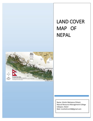
Land cover map of Nepal.pdf
- 1. LAND COVER MAP OF NEPAL Name: Shishir Mahatara Chhetri Natural Resource Management College Udaypur, Katari Mail: mcshishirsm58@gmail.com
- 2. Study area This study covered the whole territory of Nepal which is located between latitudes 26°22'–30°27′N and longitudes 80°04'–88°12′E, with an area of 147,516 km2 . Politically the country is divided into seven federal states and 77 districts. The land cover in Nepal mainly includes different types of forests (broadleaf, needle leaf, mixed), croplands, shrub lands, grasslands, bare lands, Built Area, Clouds as well as permanent ice/snow (Wang, 2004; Uddin et. al., 2015). Nepal has five climatic zones, Tropical zone lie below 1000m, Subtropical zone 1000- 2000m), Temperate zone (2000-3000m), Subalpine zone (3000-4000m), Alpine zone (4000-5000m).
- 3. Land cover Map Land cover is the physical material at the surface of Earth. Land covers include Grassland, Trees, Bare ground, Water, flooded vegetation, Agricultural Crops, Built Area etc. Land use is the term used to describe the human use of land. It represents the economic and cultural activities (e.g., agricultural, residential, industrial, mining, and recreational uses) that are practiced at a given place. Land use differs from land cover in that some uses are not always physically obvious (e.g., land used for producing timber but not harvested for many years and forested land designated as wilderness will both appear as forest-covered, but they have different uses). Land use changes occur constantly and at many scales, and can have specific and cumulative effects on air and water quality, watershed function, generation of waste, extent and quality of wildlife habitat, climate, and human health.
- 4. Types of land Use categories and Description 1. Water Areas where water was predominantly present throughout the year; may not cover areas with sporadic or ephemeral water; contains little to no sparse vegetation, no rock outcrop nor built up features like docks; examples: rivers, ponds, lakes, oceans, flooded salt plains. 2. Trees Any significant clustering of tall (~15 feet or higher) dense vegetation, typically with a closed or dense canopy; examples: wooded vegetation, clusters of dense tall vegetation within savannas, plantations, swamp or mangroves (dense/tall vegetation with ephemeral water or canopy too thick to detect water underneath). 3. Flooded vegetation Areas of any type of vegetation with obvious intermixing of water throughout a majority of the year; seasonally flooded area that is a mix of grass/shrub/trees/bare ground; examples: flooded mangroves, emergent vegetation, rice paddies and other heavily irrigated and inundated agriculture. 4. Crops Human planted/plotted cereals, grasses, and crops not at tree height; examples: corn, wheat, soy, fallow plots of structured land. 5. Built Area Human made structures; major road and rail networks; large homogenous impervious surfaces including parking structures, office buildings and residential housing; examples: houses, dense villages / towns / cities, paved roads, asphalt. 6. Bare ground Areas of rock or soil with very sparse to no vegetation for the entire year; large areas of sand and deserts with no to little vegetation; examples: exposed rock or soil, desert and sand dunes, dry salt flats/pans, dried lake beds, mines. 7. Snow/Ice Large homogenous areas of permanent snow or ice, typically only in mountain areas or highest latitudes; examples: glaciers, permanent snowpack, snow fields. 8. Clouds No land cover information due to persistent cloud cover. 9. Rangeland Open areas covered in homogenous grasses with little to no taller vegetation; wild cereals and grasses with no obvious human plotting (i.e., not a plotted field examples: moderate to sparse cover of bushes, shrubs and tufts of grass, savannas with very sparse grasses, trees or other plants.
- 5. Application of land cover mapping Local and regional planning Disaster management Vulnerability and Risk Assessments Ecological management Monitoring the effects of climate change Wildlife management. Alternative landscape futures and conservation Environmental forecasting Environmental impact assessment Policy development Reference forest and land cover analysis. (2019). forest research and traning center. (Wang, 2004; Uddin et. al., 2015) http://nfgrcnepal.blogspot.com/2007/07/grassland-resources-in-nepal-by.html http://www.esri.com